Agro climatic zone of India by ICAR 05-Nov-2022.pdf
•
0 likes•817 views

Agro climatic zones of India divided by 15 zone on the basis of water surplus,water deficit and cropping systems, how to create graph, average annual rainfall,pass through river, State, soil , growth period, through map

Recommended
More Related Content
What's hot
What's hot (20)
Similar to Agro climatic zone of India by ICAR 05-Nov-2022.pdf
Similar to Agro climatic zone of India by ICAR 05-Nov-2022.pdf (20)
More from Ravi Yadav
More from Ravi Yadav (19)
Recently uploaded
Recently uploaded (20)
Agro climatic zone of India by ICAR 05-Nov-2022.pdf
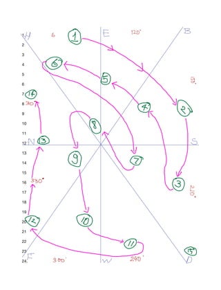
- 1. 1. 2 3 4 5 6 7 8 9 10 11 12 ' 13 14 15 16 17 18 19 20 21 22 23 24. H 6 E 120 4 it X I y
- 2. Zone 1 – Western Himalayan Region: Jammu and Kashmir, Uttar Pradesh • The region has perennial streams due to high rainfall and snow-covered mountain peaks of • Ganga, Yamuna, Jhelum, Satluj and Beas,The amount of average annual rainfall is 150 - 200 cm/ 1500-2000 mm.Maize, wheat, potato, barley are important crops Zone 2 – Eastern Himalayan Region: Assam, Sikkim, West Bengal and all North-Eastern states It • is characterised by rugged topography, thick forest cover and sub-humid climate (rainfall over 200 cm; temperature July 25°C-33°C, January 11°C-24°C.Rice, potato, maize, tea and fruits (orange,
- 3. pineapple, lime, litchi etc.) are the main crops Zone 3 – Lower Gangetic Plains Region: Bihar, West Bengal and Assam valley. Here the average • amount of annual rainfall lies between 100 cm-200 cm. Temperature for July month varies from 26°C-41°C and for January month 9°C-240C .The problem of waterlogging and marshy lands is acute in some parts of the region.Rice is the main crop. Zone 4 – Middle Gangetic Plains Region: It eastern Uttar Pradesh and Bihar (except the • Chotanagpur plateau). Ganga River , annual rainfall between 1211 and 1470mm Zone 5 – Upper Gangetic Plains Region: Uttar Pradesh,average annual rainfall 721 to 979 mm,The • soil is sandy loam. It has 131 per cent irrigation intensity and 144 per cent cropping intensity Zone 6 – Trans-Gangetic Plains Region: Punjab, Haryana, Delhi and Rajasthan • Zone 7 – Eastern Plateau and Hills Region: Maharashtra, Uttar Pradesh, Orissa and West Bengal , • Chotanagpur plateau, Rajmahal Hills, Chhattisgarh plains and Dandakaranya. 1271-1436 mm of annual rainfall. • Soils are red and yellow with occasional patches of laterites and alluviums. • Rainfed agriculture is practised growing crops like rice, millets, maize, oilseeds, ragi, gram and • potato. Zone 8 – Central Plateau and Hills Region: MP, Rajasthan, Uttar Pradesh.average annual rainfall • from 400-1550 mm Zone 9 – Western Plateau and Hills Region: Maharashtra, Madhya Pradesh and Rajasthan. • average annual rainfall from 602- 1040mm,Net sown areas are 65 % and forests occupy only 11 %. Only 12.4 % of the area is irrigated. Zone 10 – Southern Plateau and Hills Region: Andhra Pradesh, Karnataka, Tamil Nadu. only 50 % • area cultivated, 81 % dryland farming, and low cropping intensity of 111 %. Co ee, tea, cardamom and spices are grown along the hilly slopes of the Karnataka plateau. •
- 4. Zone 11 – East Coast Plains and Hills Region: Orissa, Andhra Pradesh, Tamil Nadu and • Pondicherry Zone 12 – West Coast Plains and Ghat Region: Tamil Nadu, Kerala, Goa, Karnataka, Maharashtra • Zone 13 – Gujarat Plains and Hills Region: Gujarat • Zone 14 – Western Dry Region: Rajasthan • Zone 15 – The Islands Region: Andaman and Nicobar, Lakshadweep •