2. GNSS – Global
Navigation Satellite
System- A
constellation of
satellites providing
signals from space to
facilitate autonomous
positioning,
navigation, & timing
on a global scale.
GPS
(Global Positioning
System) - USA
GLONASS
(Glogalnaya
Navigationnaya
Sputnikovaya Sistema) –
Russian Federation
Galileo European Union
BDS
(BeiDou Navigation
Satellite System) –
Chinese
IRNSS
(Indian Regional
Navigation Satellite
System)
QZSS
(Quasi-Zenith
Satellite System) -
Japanese
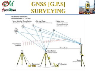
3. GPS techniques are similar to trilateration (measurements of distances to
fixed positions) principles.
Ranges – GPS distances
Ranges are measured to satellites orbiting above the earth
20,000 km – orbital altitude
GPS receivers – Passive systems, gather signals from satellites (position
information packets)
4. Time measurements
• Assist in range determination
GPS satellite signals travel
one way to the receivers.
Signal encodes – departure
(satellite) & arrival
(receiver) time.
Using the Signal speed and
time taken, range
computations are possible.
5. Satellites are the GPS
control points
Components on GPS
signals
•Time on the satellite
•Instantaneous position of
the satellite
•Atmospheric corrections
information
•Satellite identification
information
GPS satellites
communicates by
codes using Carrier
waves by phase
modulation
(information
encoding).
At least 4 GPS
satellites required for
new point definition
6. GPS codes- are binary, zeroes and ones.
Legacy codes:
• Precise or P(Y) - carries raw data
• Coarse/Adjustment (C/A) – carries raw data
• Navigation (Nav) – carries ephemeris (GPS satellite
position) & data for time conversion, clock corrections.
New codes:
• M
• L1C
• L2C (note L for L-band EM spectrum)
Carrier wave characteristics must allow modulation – phase, amplitude or frequency