SlideShare a Scribd company logo
1 of 67
Download to read offline
№39/2020
Norwegian Journal of development of the International Science
ISSN 3453-9875
VOL.3
It was established in November 2016 with support from the Norwegian Academy of Science.
DESCRIPTION
The Scientific journal “Norwegian Journal of development of the International Science” is issued 12 times a year
and is a scientific publication on topical problems of science.
Editor in chief – Karin Kristiansen (University of Oslo, Norway)
The assistant of theeditor in chief – Olof Hansen
 James Smith (University of Birmingham, UK)
 Kristian Nilsen (University Centre in Svalbard, Norway)
 Arne Jensen (Norwegian University of Science and Technology, Norway)
 Sander Svein (University of Tromsø, Norway)
 Lena Meyer (University of Gothenburg, Sweden)
 Hans Rasmussen (University of Southern Denmark, Denmark)
 Chantal Girard (ESC Rennes School of Business, France)
 Ann Claes (University of Groningen, Netherlands)
 Ingrid Karlsen (University of Oslo, Norway)
 Terje Gruterson (Norwegian Institute of Public Health, Norway)
 Sander Langfjord (University Hospital, Norway)
 Fredrik Mardosas (Oslo and Akershus University College, Norway)
 Emil Berger (Ministry of Agriculture and Food, Norway)
 Sofie Olsen (BioFokus, Norway)
 Rolf Ulrich Becker (University of Duisburg-Essen, Germany)
 Lutz Jäncke (University of Zürich, Switzerland)
 Elizabeth Davies (University of Glasgow, UK)
 Chan Jiang(Peking University, China)
and other independent experts
1000 copies
Norwegian Journal of development of the International Science
Iduns gate 4A, 0178, Oslo, Norway
email: publish@njd-iscience.com
site: http://www.njd-iscience.com
CONTENT
EARTH SCIENCES
Ayapbekova A., Auezova Z.,
Zhunussova A., Baimoldaeva A., Nurmat A.
REGULARITIES OF REFLECTION OF NATURAL
CONDITIONS IN TOPONYMS OF KAZAKHSTAN ...........3
Kyselov Iu., Shutak K.
SHAPING SCIENTIFIC FUNDAMENTALS OF RESEARCH
ON SETTLEMENT HYDROECOSYSTEMS .......................9
Sopov D., Sopova N.
ZONING OF THE TERRITORY OF THE NOTHERN PART
OF LUHANSK REGION (UKRAINE) BY THE SIGNS OF
ECOLOGIAL MODE OF LAND USING ..........................12
ECONOMIC SCIENCES
Blokhin P.
MAIN CHARACTERISTICS OF THE PEACEBUILDING
FUNCTION ECONOMIC SECURITY..............................16
Omirbayeva B., Zagidullina G., Gaitova K.
ANALYSIS OF HEALTHCARE COSTS IN KAZAKHSTAN
FOR EFFECTIVE PLANNING........................................21
Prokofiev E., Savchenko T.
INFLUENCE OF UKRAINE'S INTEGRATION IN THE
EUROPEAN UNION ON THE INSURANCE
CONTRIBUTION SYSTEM OF NATURAL PERSONS......26
Chernopyatov A.
ANALYSIS OF THE DEVELOPMENT AND PROBLEMS OF
ENTREPRENEURSHIP IN THE RUSSIAN FEDERATION.31
Skulskaya L., Shirokova T.
PROBLEMS AND PROSPECTS OF VEGETABLE
GROWING OF THE CLOSED SOIL................................35
HISTORICAL SCIENCES
Nurmamatov J.Q.
SOME INFORMATION REGARDING THE HISTORY OF
THE VILLAGES AND TOWNS OF THE
KHOREZMSHAKHS’ PERIOD
(XII- THE BEGINNING OF XIII CENTURIES)..................40
Bespalov A.
1710 - BATTLE FOR SPAIN .........................................42
JURISPRUDENCE
Yermekova A.
LEGAL ASPECTS OF INTERNATIONAL COOPERATION
OF STATES IN THE FIELD OF ROBOTICS AND
ARTIFICIAL INTELLIGENCE .........................................55
Dyrdin M., Hrytsiuk I., Tyshchenko K.
JUSTICE JUDICIALS: PROBLEMS OF THEORY AND
PRACTICE...................................................................57
Gudima K.
INSTITUTE OF CRIME IN TRANSDNIESTRIA, CRITICAL
PROVISIONS AND WAYS OF THEIR IMPROVEMENT..61
Zhumagulova Sh., Orazbekov R.,
Abu N., Ashirkhan G.
ENTITLED TO A LIFE AND THE CAPITAL
PUNISHMENT ............................................................64
Norwegian Journal of development of the International Science No 39/2020 3
EARTH SCIENCES
REGULARITIES OF REFLECTION OF NATURAL CONDITIONS IN TOPONYMS OF
KAZAKHSTAN
Ayapbekova A.,
candidate of geographical sciences, Turan-Astana University, Nur-Sultan, Kazakhstan
Auezova Z.,
candidate of geographical sciences, Professor, Turan-Astana University, Nur-Sultan, Kazakhstan
Zhunussova A.,
Doctor of profile, University of Turan-Astana, Nur-Sultan, Kazakhstan
Baimoldaeva A.,
candidate of geographical sciences, Turan-Astana University, Nur-Sultan, Kazakhstan
Nurmat A.
master, lecturer, University of Turan-Astana, Nur-Sultan, Kazakhstan
Abstract
In the case of the name of the Republic of Kazakhstan, the history of the analysis of the geographical location,
the principle of systematic systematization is analyzed.
Keywords: geographical names, toponyms, geosystem, landscape, macrotoponyms, microtoponyms, geo-
graphical environment
Currently, scientific research is most dynamically
and fruitfully developing at the junction of several areas
of knowledge. Such is toponymy - the science of geo-
graphical names. As a branch of knowledge, it has been
actively developing for a long time, but interest in it
from both scientists and ordinary people is not decreas-
ing but is constantly increasing. Geographic names or
place names are an essential component of geography
and tourism. They are a kind of connecting link be-
tween a person and a geographic object, not only indi-
cating his place on the surface of the planet but also
providing interesting and often very important scien-
tific information.
Geographical names are an expression of the men-
tality of people, their attitude, culture, way of life, cus-
toms, psychological state. They are an integral part of
modern civilization and represent a unique toponymic
environment, without which the existence of humanity
is impossible.
Geosystem as a material system is an integrated
set of natural components that complement each other
and develop in the close relationship between space and
time.
Geosystem (in Greek, the word geo means land
and system) is the geomorphological (landscape) and
geochemical basis of ecosystems [1]. Geosystem and
ecosystem are related concepts. However, in compari-
son with ecosystems, geosystems include complexes of
production regions and regions of concentration of pro-
duction enterprises. In the structure of the development
of the geosystem, there are mainly 3 levels: planetary,
regional and local (local).
On the surface of the earth, the planetary level is
represented by one instance - the geographic envelope,
which means “outer shell of the earth”, is used as the
term “epigeosphere” [2].
Geosystems at the regional level contain the larg-
est, as well as in terms of structure, complex parts -
landscape zones, sectors, regions.
The systems of the local (local) level include set-
tlements.
Geosystems of regional and local level are the
main form of landscape searches. A geosystem based
on spatial differentiation is considered in two direc-
tions: direct and indirect. Each individual set of incom-
ing actions along vertical chains is subdivided into
other components, and according to horizontal connec-
tions, it branches into neighboring geosystems. As a re-
sult of this, not only the structure and development of
the geosystem subjected to direct influence change,
changes also occur in geosystems located at a certain
distance from it.
At the present stage of development, Kazakhstan
faces important tasks of solving environmental and
economic problems, a comprehensive study of the rela-
tionship between society and nature. In this regard, the
science of geography is faced with the task of forming
the scientific basis for protecting the geosystem and the
efficient use of its resources.
The variety of parameters of Spatio-temporal fac-
tors that cause landscape changes, the variety of species
of individual components of the “degree of stability”
requires the use of scientific geographical techniques
and methods in the process of landscape restoration.
According to the rules of geographical forecasts, in the
process of studying the history of development, assim-
ilation, and change of landscapes, along with other sec-
tions of geography, toponymy is of great importance.
Toponymic information can also be included in the data
"testifying" about landscape changes. The geographical
and toponymic aspects of the study of the complex re-
lationships between society and the geosystem are most
clearly represented by the example of the toponymy of
geographical landscapes.
Kazakhstan’s land is rich in geographical names,
if on average 1 name per 1 km2 is one name, then in
our country, it is estimated that there are about 2.5-3
million geographical names. The abundance of these
4 Norwegian Journal of development of the International Science No 39/2020
names was greatly influenced by life, the ecological
culture of previously nomadic, semi-nomadic and set-
tled civilizations that inhabited our country. As the
French enlightener, Charles Louis Montesquieu (1689-
1755) noted, "The human face of the people is closely
related to local weather conditions, climate, and land
area." Following the researcher, we believe that topon-
ymy also has a significant impact on it [3]. The
worldview of the people is formed and developed in the
framework of the development of the nature of the en-
vironment, the fishing of ancestors and lifestyle. Geo-
graphical names formed in the framework of the no-
madic way of life in the verbal era (in the absence of
writing), having gone through various historical tests,
have come down to us as invaluable wealth left in the
popular memory from the well-known biys and zhyrau.
For the world of nomads who were able to adapt
the seasonal conditions of the steppe expanses as
sources of life, geographical names were of particular
importance. Features of the use of nature by the Kazakh
people enriched the substantial load of the system of
toponymy. According to the famous orientalist, scien-
tist, academician V.V. Bartoldt "... the toponyms of the
Turkic peoples surprise with their simplicity and histo-
ricity."
As far as the living conditions of mankind de-
pended on the earth, so deeply did people know and ap-
preciate the features of this land [4]. If heaven was con-
sidered a God, the earth was a mother. Since, their
whole life, joys, interests, living conditions were asso-
ciated only with their native land.
What a profound meaning, what a pithy content,
what a high poetic feeling is contained in the words of
the people's guardian, philosopher Asan Kaiga! Re-
searcher A. Seidimbekov, relying on historical, geo-
graphical, archaeological, ethnographic data, that we
have no right not to consider geographical names as a
kind of folk art. Geographical names reflect not only
the attitude of the people to the environment, under-
standing, perception of that environment, you can also
find clues to the secrets of the pedigree of each individ-
ual person, whole clan, tribe, people. That has taken
place earlier in the expanses of our native land and has
reached the continuity of generations, their criteria for
perception of the world, love for the diversity of the
beauties of nature, all this is so clearly reflected in geo-
graphical names.
The Kazakh people have always attracted re-
searchers with the richness of their language, and con-
sidered it a historical phenomenon to become the basis
for the formation of a scientific Kazakh language.
About this fact, the author of the book “Taurikh
Hamsa” K. Khalid, published in 1910 in the Chagatai
language, says the following: “It surprises me when
they say that the Kazakh people are unenlightened. But
is it possible, without studying the foundations of sci-
ences, to know the special foundations of geography,
astronomy, to distinguish between symbols, signs of the
earth and speak, choosing the exact names for them. "
For example, they say "Uyryk sauyry Quesin, Arқa
gandy, surun zhailau, sary bel." "Surun" in Persian
means "yellow." The yellow steppe, therefore, was
called so. "Zhon" (elevation), a higher elevation is
called "belge", less is called "whitish." Atyғaisorkeseң
iscalledasmall, lowelevation.
The selection in Kazakhstan of local geographical
names, the features of their appearance are closely re-
lated to natural conditions, the history of the people and
the history of linguistics. From history, we know that in
the 14th-16th centuries, due to the widespread develop-
ment of a settled lifestyle, large cities, winters and other
settlements began to be built at the mouth of the Zhayyk
River. The above historical stages, the main stages of
the socio-political life of the Kazakh people in the So-
viet era - all this leaves its mark on popular place
names. Researcher B. Tleuberdiev, who studied the
names of the southern region, identifies the following
factors that influenced the formation of the features of
toponyms:
Geographical factor;
Ethnographic factor;
Socially historical factor.
From ancient times, our people, choosing the
names of geographical objects, took as a basis one of
these factors:
if the formation of one group was influenced by
geographical symbols (features of the earth, peace ani-
mals, flora);
for the formation of another group of names, the
direct influence was exerted by the peculiarities of life
and the vital activity of our people;
the third group of names was associated with the
consequences of historical, socio-political events.
Toponyms of the Kazakh language were formed
directly under the influence of the three above factors.
Therefore, a scientific description of place names, from
their appearance to the present day, consideration of the
morphological composition of place names in connec-
tion with their linguistic patterns, their analysis from
the position of geographical names and international
geographical terms, are possible provided that the na-
ture of geographical names is correctly understood, the
reasons for their formation and their social significance.
It should be noted that the formation of place
names is closely related to the description of local nat-
ural conditions and the economic needs of the people.
Toponyms of the Republic of Kazakhstan are di-
vided into two large groups. One of them is the name
of large geographical objects, the second is the name of
small objects. These two groups are called onomastic
scientific terms "macrotoponym" and "microtoponym."
Macrotoponyms (it is translated from Greek.
"Macro" - "large") - the names of large physical, geo-
graphical objects that have become official are widely
used by the people. Macrotoponyms are related to the
features and richness of the nature of the region, its
landscape, the economy of the local population. Profes-
sor A.M.Selishchev on toponyms related to the land-
scape said the following: "... the features of the earth's
surface, which is reflected in individual natural regional
complexes, can only be seen thanks to the toponyms" -
the name Aktobe (white roof) is often found in Kazakh-
stan , the name of Karaganda (the name of the plant is
Karaganda), the name of Eginzhal (sowing field), the
name of Zhartas (rock), the name of Apan (depression),
the name of Bidayyқ (bidayyk grass that grows on the
Norwegian Journal of development of the International Science No 39/2020 5
pasture), etc. Thus, the natural features of the land de-
termine Delyan geographical names.
And microtoponyms (translated from the Greek
language - “small”) are the names of small physical ge-
ographical objects characteristic of the region, that is,
the names of rivers and lakes, keys and sources, wells
and streams, ravines, ridges, hills, hills, meadows and
grasslands, wintering grounds and pastures. Macrotop-
onyms and microtoponyms in linguistics were first
used by researchers A.V. Superanskaya and E.M. Mur-
zaev.
Among the most numerous toponyms of
Kazakhstan, microtoponyms can be distinguished.
Their multiplicity is due to a natural reason. The natural
conditions of the regions of Kazakhstan are
characterized by diversity. Each region is distinguished
only by its characteristic natural conditions and
numerous natural landscapes. Formed in the
evolutionary system, each natural zone has a specific
climate, features of the regime of water and heat,
different soil and vegetation, features of the animal
world. 90% of the land surface of the territory of
Kazakhstan - plains and sown areas. The natural
diversity of most desert sand landscapes serves human
economic needs.
In the process of historical research of historical
and geographical conditions for the formation of
toponyms of Kazakhstan, it is necessary to consider not
a single era, but in the relationship, starting from
ancient times. Violation of ecological harmony in the
geosystem, the appearance of landscape changes, we
can explain thanks to ancient toponyms. Carrying out
toponymic studies within the framework of the above
problems of the geosystem provides an opportunity to
consider the formation of the economy and culture as a
holistic legal system.
Fruitful toponymic research can be developed us-
ing the methods and achievements of linguistic, histor-
ical and geographical sciences:
geographer - supplies and comments on the geo-
graphical conditions for the emergence of a toponym;
linguist - analyzes and explains the origin, content
and grammar;
historian - explains the ethnographic origin of the
name.
Toponymic methods:
- Linguistic analysis
- Comparative analysis
- Historical method
- Etymological analysis - the origin of the name
Geographical - the specifics of names in different
places: with a homogeneous ethnic group - the name
along the entire river - the Dnieper, Danube, Morava,
Syrdaria, etc. In areas with a diverse ethnic composition
- the local synonymous nomenclature Volga - Ra
(Mord.) - Itil (Turk) - Yul (Mari). Different peoples
have different toponymic patterns: Before - east (Turk),
south (hulk-Mongols and Chinese).
If you neglect one of the sides of the study, you
can get various incidents - "kunges" - quiet. But the
Tekes River flows nearby. Such a pair is named accord-
ing to the orientation of the current: current in the sun -
kunges, current north - tekes (Kungey and Terskey
Alatau).
Geographical names are spatially linked and often
reflect the nature of the landscape, talk about the nature
of human settlement of the territory, about the natural
wealth and other geographical and historical features of
the territory. Often the name is due to the nature of the
geographical object itself, so many popular folk geo-
graphical names have turned into terms: taiga, ustyurt,
zhtylt, steppe, etc.
When orienting, there is a synonymy of concepts -
south and front (ovor). North and back (ar), east and left
(dzun), light and right (barun)
In the Azerbaijani language, cardinal points are in-
dicated by colors - ag –white – east; gara - black, dark-
ness - west.
Toponymic studies of Central Asia were carried
out by many famous scientists, starting from V. Radolw
and B Barthold, but in their studies, these topics were
not main, but related. A systematic study of the topon-
ymy of Kazakhstan began in the 50s of the twentieth
century. It should be noted the pioneer of Kazakh to-
ponymy G. K. Konkashpayev (Dictionary of Kazakh
geographical names. Alma-Ata, 1963), A.A. Abdrakh-
manova (the dissertation "Some questions of toponymy
of Kazakhstan), E. Koichubaeva (A Brief Explanatory
Dictionary of Toponymy of Kazakhstan. Alma-Ata,
1974), E. M. Murzaeva (Dictionary of Popular Geo-
graphic Terms. - M., 1984).
Turkestan has an ancient culture. Some names are
known from ancient sources of two to three thousand
years ago (Samarkand, Khorezm, Paropamiz).
The most ancient of the toponymic strata is Ira-
nian. The largest share of them is in Central Asia, espe-
cially in Tajikistan: about - water, river (Surkhob, Ya-
gnob, Obihingou), kuhi- mountain (Kuhistan), Daria -
big river (Syr-Daria), Balkan, Zeravshan, Lyangar, etc.
Arabic place names are associated with the spread
of Islam. Examples include Arslanbob, Jebel, the Gis-
sar Range, a valley, a rabad fortress or city suburbs, a
Mazar grave, a tomb, a mahalla - a city quarter.
Turkic place names are found almost everywhere,
dating from the century, most widely from the 10th cen-
tury.
Some features of the toponymy of Central Asia
and Kazakhstan:
Frequent variability of the names of the same
river. The river is called differently, taking a large trib-
utary, changing the direction of the valley or relief. (Ka-
rakol + R. Suek = Kochkor + R. Juvanaryk + Chu;
Surkhob - Vakhsh + Pyanj + Amu Darya).
The rivers flowing from one ridge, saddle or top in
different directions have the same name (because the
name is given from the name of the pass or mountain
passage) - 6 rivers under the name Koysu flow from
Kungei-Alatoo, have prefixes, 2 - ortho-; Karakol
Chuisky and Karakol Susamyr, etc.
In the Tien Shan and the Pamirs, mountains are
called by the river flowing down from them (Kokshaal-
Tau, Dzhumgaltau, ridge Muzkol, Zeravshansky,
Alaysky, Talas ridge.
Many names of mountain ranges arose as artificial
formations. It is based on local geographical terms,
6 Norwegian Journal of development of the International Science No 39/2020
which subsequently spread to larger objects or intro-
duced by researchers of these places (Tien Shan,
Zeravshan ridge, Zailiysky Alatau, Gissar ridge).
Large rivers get their names from ancient large cit-
ies (Amu Darya, Khojentdarya, Talas, Tedzhen, etc.)
Detailed specialization of elements related to hu-
man production activities (in deserts and in the Tien
Shan mountains a large number of names are associated
with the characteristics of pastures, forms of valleys
and passes; in Central Asia - with irrigation facilities -
aryk, arna, kyariz, bent).
From the first days of his existence, a person re-
ceives everything necessary from the geographical en-
vironment that protects human society, and nature is a
necessary stable condition for the material life of a so-
ciety. In a geographical environment, the meanings of
the two concepts “nature” and “man” are closely inter-
connected [6]. In connection with the appearance of
man, the formation of society, a new type of relation-
ship is being built: man - society - nature. Humanity
from century to century, from era to era, has gradually
risen to the level of assimilation of the natural laws of
the geographical environment, has reached the level
when united in groups, they began to master the wealth
of nature. In Kazakhstan, one can find traces of the cen-
turies-old evolution of mankind. Academician V.V.
Bartold and orientalist, archaeologist P.S.Savelyev
write about the variety of different buildings, about the
fact that in the Middle Paleolithic era, 30-40 millennia
before that, the ancient first camps of the communities,
the stone industry, ancient metallurgical products, a car-
avan –Sheds and military fortresses, ancient buildings.
The Mangystau region was at one time an important
point of communication between Khorezm and Itil, the
researcher writes that ancient monuments, stone for-
tresses, and palaces have been preserved in the vicinity
of Mangystau [7].
It should be noted that the assimilation of the laws
of the geographical environment is the first condition
for the existence of human society, their use in order to
ensure the material and spiritual needs of man. If we
talk about thinking as a means of knowing nature, then
the expression of thinking occurs through language.
Because language and thinking are closely intercon-
nected. This is also familiar to us from the teachings of
the famous scientist I.P. Pavlov about the two-signal
system. I.P. Pavlov revealed that animals have no
speech, therefore there is no thinking, animals have a
one-signal system, and a person has a two-signal sys-
tem and it is the physiological basis of thinking. The
scientist showed that "the word, being a signal of the
first signals, formed the second system of real life, a
system of signals characteristic of us." These principles
are the same for speech and writing, but they have their
own characteristics. From this position, it is safe to say
that the Kazakh people through the mother tongue got
the opportunity to spiritually learn and master the na-
ture of the geographical environment. The Kazakh peo-
ple expanded their thoughts on the geosystem of the ge-
ographical environment in the minds of certain con-
cepts and in the form of abstractions. Since the vital
activity of the Kazakh people was closely related to na-
ture. Thus, the geographic environment is the surround-
ing geosystem, which creates vital conditions for the
life of the country. As society develops, natural phe-
nomena expand and change. For millennia, our people
have existed due to the nature of the geographical envi-
ronment, paid attention to its many secrets and came to
certain conclusions about it.
The oral nature of the spiritual culture served as
the basis for the nomadic society to pay special atten-
tion to the word. It should be noted that the ethnos of
the Kazakh people have well-developed features such
as abstract thinking, the use of figuratively expressive
means, the preservation of the information heard. This
was proved by the opinion of a nineteenth-century re-
searcher N. Zelendt: “The Kyrgyz (Kazakhs) in pre-
serving in memory the location of environmental ob-
jects, people and land will leave cultural people far be-
hind.” In the conditions of a nomadic way of life, these
properties made the heritage of spiritual culture vital,
had a special impact on the data section of the dispersed
Kazakh society. From these positions, one can explain
the preservation of Kazakh toponyms over the centuries
and their formation by using them as a source of infor-
mation and features formed in the process of influence.
The oral nature of the traditions of creativity of the Ka-
zakh people justifies the need to transfer environmental
experience in the process of cognition and use of nature
by special methods. A proof of this is the frequent use
of metaphors in oral folklore and place names.
Fertile land, convenient parking as a symbol of
spiritual condition Zhidelbaysyn is found in the Kazakh
epos Alpamys, Kazyland, Er Targyn and other epics of
folklore. In the fifteenth century, the people's guardian,
the sage Asan Kaigy, sat on a horse, traveled all the
lands, mountains, rivers and lakes of our country, de-
voting his life to the people. In the places where he vis-
ited he gave an assessment: good or bad settlement. The
critical assessment of the sage has a deep meaning, a
multifaceted geographical study, an extraordinary un-
derstanding:
The author characterizes the surroundings of
Zhaia and Zhem, as places free of charge for animal
husbandry, favorable for human habitation, and the fish
living in these waters give off the taste of oil.
Nomads went through a socio-historical for-
mation, the longest formation in the history of mankind.
Steppe clans and tribes, who lived long before our reck-
oning, who managed to form a nomadic way of life with
this way of life, came to the twentieth century. “From
the 11th century to the 18th century BC, only one pro-
duction method was known in the Eurasian steppes, this
is nomadic animal husbandry,” notes L.N. Gumilev [8].
Both the positive and negative sides of this method are
known for the world of nomads. Negative: countries of
Asia, Eastern Europe, North Africa went through vari-
ous stages of historical development. All this has a sig-
nificant impact on the development of society at the
stage of the socio-economic stage in a new quality,
along with this on the ideological thinking, aesthetic
perception of entire nations.
And when we talk about the benefits of a nomadic
way of life that has lasted for millennia, it should be
noted that "being a nomad, socio-economic life strove
Norwegian Journal of development of the International Science No 39/2020 7
for spiritual unity, did not stop its qualitative improve-
ment." The culture of nomads over their 3000-year his-
tory, compared with the Gerort Sea and the countries of
the Far East, survived a creative evolution ” [9]. They
not only improved the methods of animal husbandry
but also developed everything, from objects and means
of daily consumption to moral and ethical standards of
perception, starting from ancient folk songs and cues to
language. We were attracted by the following thoughts
of the scientist L.N. Gumilyov: “I am a historian by ed-
ucation, and if necessary, I am an ethnologist. It is im-
possible to explore in the traditional way describing
events the history of not only the disappeared peoples
but also the peoples living on the earth now [10]. After
that, in order to gain experience, to take as a basis, I was
forced to turn to the geographical cycle. In my under-
standing, ethnology is a special science that draws in-
formation from materials from history, geography, and
ethnopsychology. ”
The role of the geographical environment in the
development of society has previously attracted the at-
tention of thinkers. The Arab sociologist Ibn Khaldun,
the French thinkers J. Boden, Sh. L. Montesquieu, the
English historian G. Bockle, the Russian scientist L.I.
Mechnikov, the French geographer E. Reclus and oth-
ers consider the influence of the geographical environ-
ment as a determining factor in social development. Ac-
cording to the theory of L.I. Mechnikov, the main factor
in the achievement of every nation of civilization, cul-
ture is the wealth of water resources. In the history of
mankind, the so-called "river" civilizations appeared in
the lower reaches of the rivers Nile, Tiger, Efrat, Gan-
ges, Yellow River, Yangtze [11]. It is known that after
these civilizations of the Greeks and Romans appeared
in the vicinity of the Gherort Sea, and in connection
with the era of the discovery of America, the civiliza-
tion of the "ocean" appeared.
If we turn to Kazakhstan, we will see that life, pic-
tures from everyday life, customs, traditions, clashes
described in the dastans occurred on the banks of the
Volga and Yaik, Syrdaria and Irtysh, Ayakoz and Yesil
rivers, the Caspian, Aral and Balkhash seas, the Lake
Zaysan. Rivers and lakes for the nomadic people of Ka-
zakhstan were a place that they could not leave for a
long time, even if they were nomadic people. Because,
in the spring, thanks to the floodwaters, small rivers ap-
peared in the ravines. It is known that in such places
there are many spring waters. Such fertile lands have
long been favorable for grazing, livestock farming, as
well as for human habitation.
From time immemorial, the Kazakh people have
highly appreciated the rich and generous nature of their
habitat. The traditional culture of our people is charac-
terized by praise of nature, rather than turning to reli-
gion, people sought to comprehend the secrets of na-
ture, to learn the language of nature. The Kazakhs did
not try to subjugate, change nature, but urged the
younger generation to find a common language with
nature, to always live in harmony, in harmony with it.
Although they lacked special knowledge, they sought
to understand the relationship, the harmony of the geo-
graphical environment and other hidden patterns of na-
ture. Thus, the nomads who lived in Asia began to as-
similate the mysteries of the geographic environment
from the 9th-10th centuries to our calendar. Such great
thinkers as al-Farabi, Ibn-Sina, Ulykbek made a signif-
icant contribution to the science of astronomy. They in
their works revealed some secrets of nature and brought
them on a scientific basis.
The secrets of nature are well known to our great-
grandfathers. Our great-grandfathers determined by the
stars, by the location of the bird's path, by the rise of
Venus, what the weather will be like next year, how the
months will begin and end, how the sunrise and sunset
will go. And also, the lambing of four species of ani-
mals, their return from the pasture, the making of
sounds by them helped make weather forecasts for the
next day.
The opinions of our people about nature were con-
sonant with the phenomena of nature, the laws of its
development. The Kazakh people consider themselves
to be an integral part of nature, its integral element.
Therefore, since ancient times people understood the
necessity of existence in unity, in harmony with nature.
According to the harsh conditions of nature, various
changes taking place in nature, in connection with the
nomadic way of life, people knew the price of the nat-
ural geographical biosphere of the simple world.
The pride of our people Sh. Ualikhanov attached
great importance to the sacramental: “Nature and man!
Tell yourself, what is more, wonderful and mysterious
on earth than them? - [12]. Native places in nature,
some species of birds and animals, essentials for no-
madic life were considered sacramental. It was believed
that worship, worship of the above bring people wealth,
happiness and prosperity. In the perception of the com-
mon people, the word "nature" means the sacred land.
Along with this, the people mined minerals, cultivated
the land, tamed animals, used various types of plants,
studied the features of the land landscape, the geomor-
phological structure of mountains, the volume, fresh-
ness and salinity of rivers and lakes, determining the
course of all these phenomena, the people came up with
their names and this process search and enrichment of
human experience is reflected in the language picture.
A.Abdrakhmanov considers the history of the evo-
lutionary development and formation of the Kazakh
language, dividing them into Altai (Turkic-Mongolian
unity), Old Turkic, Old Kazakh, modern Kazakh stages.
From this position, it should be noted that the concept
of “Kazakh place names” was taken conditionally [13].
The scientist considers the history of the emergence of
toponyms of Kazakhstan, dividing it into stages, and
not studying a single century, taking into account the
formation of Kazakhs as a people in the 15th-16th cen-
turies, investigated the features of the formation of top-
onyms that are characteristic of all Turkic peoples.
The toponymic geosystem of Kazakhstan is based
on geographical names that demonstrate the physical
and geographical properties of the environment. In their
formation, patterns are observed that are relevant to the
reflection of the properties of one particular landscape.
One group of toponyms was formed by a combination
of geographical terms (common words) and defining
words: Aydin, aғash, Apan, arka, aыыa, Bauyr, bastau,
8 Norwegian Journal of development of the International Science No 39/2020
bұlak, Bidayyk, kөbіk, kөl, kүtіr, kala, kara, kamy,
korys, kұdyk, kұlak, kұm, kystau, both, oh, өzen, өзек,
сai, Sor, su, Suat, Tal, tas, Terek, toғay, tөbe, tүbek, tұz,
shat, shaғyl, Shegen, shyғanak and others.
Kazakhstan's regional geographical terms or ap-
peals were used to designate natural objects and were
formed as a basis demonstrating the features of the
landscape in the process of the formation of geograph-
ical names. Toponyms of Kazakhstan are in harmony
with the conservative landscapes of the region and its
components and are also characterized by a modern,
well-established structure. A striking example of this is
the names of salt licks and salt places of Kazakhstan.
These names are the main indicator of the lithological
structure (precipitation and sedimentary phenomena
that appeared from the systematic origin of the moun-
tains) of the strata of the terrain, climatic conditions,
and terrain.
In the toponymic system of the geosystem of Ka-
zakhstan, a special place is occupied by names inform-
ing about the nature of a particular area. In the selection
of the names of physical and geographical objects, the
people firstly chose a criterion for the significance of
natural conditions for farming. Based on this, the main
indicators of the natural conditions of the region of the
Republic, the reflection of geographical names are de-
termined by the significance of these indicators for
farming. Among the geographers who studied the rela-
tionship of toponyms with the natural environment are
V.P. Semenova, E.M. Murzaev, B.A. Budagova, H.L.
Khanmagomedov, G. Konkashbaev, A. B. Birmagam-
betov, S. Orynbaev, Zh.D. Dostaya, E. Kerimbaeva, A.
Margulan, S. A. Abdrakhmanov, K. B. Bazarbaev, S. R.
Satimbekova, N. Bayandina, M. Serikbaev, K. Zh. Zhy-
lybaeva, V.P. Maksakovsky, S. B. Bakirova, A. I.
Popova, E. M. Pospelova, D. Zhunusova, T. R. Oma-
rova. The breadth of the region of the Republic of Ka-
zakhstan, the abundance of Kazakh place names re-
quires a thorough study of this problem. Since, in the
process of reflecting in Kazakh place names the ancient
way of farming, understanding the natural conditions
from the standpoint of the needs of life, a rich cognitive
and practical knowledge fund has been collected.
We present to your attention the patterns of the im-
age of geosystem toponyms and the specific features of
natural conditions in the form of several concepts
(groups):
names reflecting the geological structure and to-
pography of the land of Kazakhstan;
reflection in toponyms of climatic catches and in-
land waters;
reflection in geographical names of vegetation and
wildlife;
toponymyofgeographicallandscapes.
REFERENCES:
1. Abdrakhmanov S.A. Toponymic policy as a
mirror of the revival of statehood in Kazakhstan. //
Sayasat, 1996. No. 12. - S. 19-26.
2. Seydimbekov A. Poyushchiye kupola -
Almaty, 1981. -240 b.
3. Hamid Kurbangali. Tauerich Hamsa (Five
Stories). - Almaty, 1992.- 296 p.
4. Murzaev E.M. Dictionary of popular
geographic terms. -– М., 1974. - 287 b.
5. Ayapbekova A.E. Toponyms are components
of geosystems: Tutorial. - Nur-Sultan: Turan-Astana,
2020. - 103 p.
6. Zhylygybaev K.Zh. Kneh tarikh kulary.-
Almaty, 1976 .-- 56.
7. Margulan A.Kh. Witnesses of an ancient
culture. Almaty, 1996 .- 177 p.
8. Gumilev L.N. Ethnogenesis and biosphere of
the earth. Volume I-III. - L., 1979.
9. Maksakovsky V.P. Geographical culture. - M.,
1998 .- 414 p.
10. Kazybekov N. Dala нrnekterі: ethnography k
sipattamalar. -Almaty, 1994 .-128 b.
11. Popov A.I. Geographical names. Introduction
to place names. - M., -L., 1965 .- 170 s.
12. Pospelov E.M. Toponymy and cartography. -
M., 1971.-124 p.
13. From History of the Kazakhs. Chronicles,
mennies, - razrabotan; N. Kulmukhambetova. - Almaty,
- 2004. - 464 s.
Norwegian Journal of development of the International Science No 39/2020 9
SHAPING SCIENTIFIC FUNDAMENTALS OF RESEARCH ON SETTLEMENT
HYDROECOSYSTEMS
Kyselov Iu.,
Doctor of Geographical Science, Professor,
Head of Department of Geodesy, Cartography and Cadastre
Uman National University of Horticulture
Uman, Ukraine
Shutak K.
Post-graduate student,
Department of Ecology and Life Safety
Uman National University of Horticulture
Uman, Ukraine
ФОРМУВАННЯ НАУКОВИХ ЗАСАД ДОСЛІДЖЕНЬ ПОСЕЛЕНСЬКИХ ГІДРОЕКОСИСТЕМ
Кисельов Ю.О.,
доктор географічних наук, професор,
завідувач кафедри геодезії, картографії і кадастру
Уманський національний університет садівництва
Умань, Україна
Шутак К.В.
аспірантка кафедри екології та безпеки життєдіяльності
Уманський національний університет садівництва
Умань, Україна
Abstract
One of the most important lines of the modern stage of development of a human civilization is essential
aggravating of hydroecological problems. Deterioration of ecological state of water objects in settled places where
the influence of anthropogenic factors that make pollution of water environment is concentrated, has an outstand-
ing social significance. Water objects in the settled places and their peripheries with the territory and the complex
of hydrotechnical buildings are shaping specifically composed objects named settlement hydroecosystems. Re-
search on those should become the content for a distinct scientific discipline named settlement hydroecology that
is shaping on the boundary of some sciences such as geography, hydrology of dry land, equistics, ecology,
noospherology, and systemology. The investigations of settlement hydroecosystems just now are quite numerous
and different at that time that shaping fundamentals of settlement hydroecology as a special discipline is yet an
acute scientific issue.
Анотація
Однією з важливих рис сучасного етапу розвитку людської цивілізації є істотне загострення гідрое-
кологічних проблем. Особливе суспільне значення має погіршення екологічного стану водних об’єктів у
населених пунктах, де сконцентрована дія антропогенних чинників, що забруднюють водне середовище.
Гідрооб’єкти в межах населених пунктів і їхніх околиць разом із територією та комплексом гідротехнічних
споруд утворюють специфічні складні об’єкти – поселенські гідроекосистеми. Їх дослідження має стати
змістом окремої наукової дисципліни – поселенської гідроекології, що формується на стику кількох наук
– географії, гідрології суходолу, екістики, екології, ноосферології, системології. Дослідження поселенсь-
ких гідроекосистем уже тепер є досить численними та різноманітними, хоча формування засад поселенсь-
кої гідроекології як спеціальної дисципліни ще є актуальним науковим завданням.
Keywords: ecological problems, water objects, settled places, settlement hydroecosystems, settlement hy-
droecology, scientific fundamentals.
Ключові слова: екологічні проблеми, водні об’єкти, населені пункти, поселенські гідроекосистеми,
поселенська гідроекологія, наукові засади.
Постановка проблеми та її актуальність.
Однією з істотних рис сьогодення є погіршення
екологічного стану всіх складників ландшафтної
оболонки планети. Не становить винятку гідрос-
фера, яка через підземні води, водяну пару, воду у
складі живих організмів пронизує інші компоненти.
Численні екологічні проблеми, що нині охопили во-
дну оболонку Землі, поширился, зокрема, на внут-
рішньоконтинентальні води, в тому числі річки та
інші водотоки й водоймища в межах населених пу-
нктів. В умовах освоєної території з наявними на
ній різноманітними джерелами забруднення вод-
ного середовища зазначені проблеми набувають
специфічних особливостей, що наводить на думку
щодо поєднаності всіх вод населених пунктів разом
із самою їхньою територією та гідротехнічними
спорудами в єдину систему. Тому, на наш погляд,
вивчення екологічних проблем гідрооб’єктів насе-
10 Norwegian Journal of development of the International Science No 39/2020
лених місць із позицій системного підходу та по-
шук шляхів їх розв’язання є вельми актуальним на-
прямом гідроекологічних досліджень.
Аналіз попередніх досліджень. Значний вне-
сок у розроблення теоретичних засад гідроекології
та гідроекологічні дослідження України здійснили
В.К. Хільчевський [1; 6; 7], І.П. Ковальчук [3; 4; 9],
А.В. Яцик, В.Я. Шевчук [8] та інші науковці, які ро-
зглядали питання екологічного стану водних
об’єктів як у цілому, так і щодо басейнів окремих
річок України, трактуючи їх разом з оточуючим
геоморфологічним середовищем як флювіальні ба-
сейнові системи. В одній із наших попередніх пуб-
лікацій наведено визначення урбогідроекосистеми
як особливої гідроекосистеми міського населеного
пункту та здійснено спробу обґрунтування науко-
вих засад урбогідроекології [2]. Водночас, за на-
шими даними, досі не сформульоване й не одер-
жало застосування поняття «поселенська гідроеко-
система», під якою треба розуміти систему водних
об’єктів разом із територією та гідротехнічними
спорудами в межах певного населеного пункту і
його околиць, та не окреслені засади поселенської
гідроекології як спеціальної наукової дисципліни.
Метою статті є формування поняття поселен-
ської гідроекосистеми як особливого складного си-
стемного утворення, пов’язаного з функціонуван-
ням води в умовах населеного пункту.
Завдання статті:
- висвітлення особливостей функціонування
водних об’єктів в умовах населених пунктів і їхніх
околиць;
- обґрунтування реальності поселенських гід-
роекосистем як поєднання всіх взаємопов’язаних
водних об’єктів у межах даного населеного пункту
разом із його територією й гідротехнічними спору-
дами;
- окреслення наукових засад поселенської гід-
роекології як наукової дисципліни, що досліджує
поселенські гідроекосистеми;
- аналіз досліджень, фактична суть яких поля-
гає у вивченні поселенських гідроекосистем.
Результати дослідження. Поряд з іншими
компонентами довкілля вагомих антропогенних
змін чимдалі більше зазнають природні води сухо-
долу – як поверхневі, так і підземні. Як правило, в
населених пунктах екологічний стан гідрооб’єктів є
менш задовільним порівняно з незаселеною терито-
рією. Причому, вода в річках може бути чистішою
не лише вище, а й нижче за течією від населеного
пункту, що можна пояснити зниженням концентра-
ції забруднюючих речовин внаслідок впадіння при-
токи з більш чистою водою.
Варто зауважити, що забруднення природних
вод може бути як прямим (надходження полютан-
тів безпосередньо у воду через діяльність промис-
лових підприємств, ферм тощо), так і опосередко-
ваним (вторинне забруднення водних об’єктів че-
рез потрапляння токсичних речовин із ґрунту).
Крім того, саме в межах населених пунктів або
безпосередньо біля них чи не найчастіше зазнають
трансформації самі гідрооб’єкти. З метою водопо-
стачання, іноді – в рекреаційних цілях, на річках
споруджуються водосховища та ставки, що, крім
фізичного збільшення площ, зайнятих водою, ви-
кликає також докорінні зміни річкового стоку й во-
дного режиму річок взагалі. Здійснюючи функції
водопостачання промислових підприємств, штучні
водоймища самі зазнають їхнього негативного
впливу через різні викиди. Отже, вони фактично
стають відстійниками шкідливих для живих органі-
змів речовин.
Неодмінною умовою функціонування населе-
ного пункту є водопостачання (централізоване або
децентралізоване), яке передбачає побудову низки
гідротехнічних споруд (водопроводи, дамби, коло-
дязі, свердловини тощо). Наявність системної орга-
нізованості сукупності об’єктів, що включає приро-
дні води в межах населеного пункту і його околиць,
а також територію та гідротехнічні споруди, наво-
дить нас на думку про існування поселенських гід-
роекосистем, які, разом з іншими чинниками, за-
безпечують функціонування міста чи села як певної
цілості.
Окреслені вище екологічні проблеми водних
об’єктів у межах населених пунктів та потреба в їх
водопостачанні переконують нас у необхідності
формулювання засад особливої наукової дисцип-
ліни – поселенської гідроекології. Її об’єктом ми
вважаємо поселенські гідроекосистеми, а предме-
том – генезу, структуру, функціонування, динаміку
та розвиток поселенських гідроекосистем.
Методологічною основою поселенської гідро-
екології є теоретичні побудови сучасної екології та
ноосферології, в тому числі концепція сталого роз-
витку, істотне місце в якій належить проблемі збе-
реження водних ресурсів для наступних поколінь
[8], а також розроблена С.П. Соньком [5] концепція
ноосферних екосистем, важливою складовою яких
є гідрооб’єкти. Іншим компонентом методологіч-
них засад поселенської гідроекології є фундамента-
льні положення гідрології суходолу та флювіальної
геоморфології, представлені у працях М.І. Мак-
кавєєва, А.Н. Стралера, В.П. Філософова, Р.С. Ча-
лова, І.П. Ковальчука, О.Г. Ободовського,
В.К. Хільчевського та інших дослідників. Ще од-
нією складовою методологічної основи поселенсь-
кої гідроекології є положення екістики, які дослі-
джують поселенські територіальні системи в
усьому поєднанні їхніх структурних складових.
Поселенська гідроекологія застосовує складне
поєднання філософських, загальнонаукових, між-
дисциплінарних і спеціальних методів дослі-
дження. Зокрема, до філософських методів нале-
жать діалектика (яка використовується, в тому чи-
слі, в аспекті співвідношення природного і
штучного у структурі й функціонуванні поселенсь-
ких гідроекосистем) та системний аналіз (при розг-
ляді сукупності водних об’єктів у межах населе-
ного пункту як свого роду системи). З-поміж зага-
льнонаукових методів важливе значення мають
описовий та логічні методи пізнання (аналіз, син-
тез, порівняння, узагальнення, систематизація
тощо). Міждисциплінарні методи представлені іс-
торико-географічним (що застосовується при розг-
Norwegian Journal of development of the International Science No 39/2020 11
ляді еволюції водних об’єктів і поселенських гідро-
екосистем у цілому впродовж часу, що минув від
початку освоєння території) та математико-статис-
тичними, необхідними при визначенні кількісних
параметрів поселенських гідроекосистем. Спеціа-
льними методами, використовуваними в поселен-
ській гідроекології, є картографічний (загальний
для всієї географії як просторової науки), картоме-
тричний (використовуваний при вимірюванні на
картах морфометричних характеристик водотоків і
річкових басейнів) та районування (виділення в ме-
жах населених пунктів і прилеглих до них терито-
рій просторових структур, які характеризуються
певними особливостями будови, динаміки та ево-
люції поселенських гідроекосистем.
Практичне значення формулювання наукових
засад поселенської гідроекології полягає у тракту-
ванні освоєних територій як поселенських гідрое-
косистем, тобто поєднання всієї сукупності наяв-
них у їхніх межах гідрооб’єктів та антропогенно
зміненого ландшафтного середовища, в якому вони
перебувають, і яке впливає на них. Ми вважаємо,
що такий підхід (який в удосконаленому й заверше-
ному вигляді може претендувати на новизну) до-
зволяє глибше вивчати відносини між природними
й антропогенними факторами формування сучас-
ного й можливих майбутніх станів водних об’єктів.
Обґрунтовуючи наукові засади поселенської
гідроекології, ми свідомі того, що дослідження в
цій сфері фактично провадилися вже тривалий час
і на сьогодні є досить численними. Варто згадати
працю провідних українських учених у сфері гідро-
логії, гідрохімії та гідроекології В.К. Хільчевсь-
кого, В.І. Осадчого та С.М. Курило «Основи гідро-
хімії», де наведено, зокрема, дані щодо хімічного
складу біологічно очищених стічних вод деяких мі-
ських населених пунктів [6]. Знаковим явищем є та-
кож, по суті, монографічна публікація І.П. Коваль-
чука та Л.П. Курганевич, присвячена проблемі гід-
роекологічного моніторингу [4]. Крім того, лише за
період 2011–2015 рр. в журналі «Гідрологія, гідро-
хімія і гідроекологія» опубліковано низку статей
українських і зарубіжних авторів, безпосередньо
присвячених водним об’єктам населених пунктів,
зокрема поселенським гідроекосистемам Києва,
Луцька, Сум, Тернополя, Чернівців та інших міст
[7]. Змістом цих та інших публікацій є, в тому числі,
результати досліджень еколого-гідрологічних по-
казників озер, екологічна характеристика річки як
індикатор екостану ландшафту, особливості річко-
вого стоку в умовах освоєних територій, проблема
техногенного, зокрема термічного, забруднення рі-
чок, водоймищ і підземних вод, кисневий режим
водних об’єктів, питання змінюваності води у шту-
чних водоймищах, аналіз структури річкових ба-
сейнів в умовах антропогенного перетворення до-
вкілля, проблема якості джерел централізованого
водопостачання, горизонтальний і вертикальний
розподіл зоопланктону та низка інших питань фун-
кціонування поселенських гідроекосистем.
Беручи до уваги виняткове значення води як
унікальної речовини на Землі, практичну повсюд-
ність її поширення, визначальну роль у виникненні
й підтримуванні життя на Землі та істотну антропо-
генну перетвореність гідрооб’єктів (причому відбу-
вається обопільний вплив – промислові підприємс-
тва забруднюють річки, озера, підземні води, а сама
вода може негативно впливати на об’єкти інфра-
структури, наприклад, зумовлювати підтоплення
будівель і споруд при їх просіданні), ми переконує-
мося в реальності існування поселенських гідрое-
косистем. Тому є потреба наголосити на недостат-
ності вживання заходів щодо охорони окремо взя-
тих річок, озер тощо, оскільки всі водні об’єкти в
межах певної території взаємопов’язані. На нашу
думку, актуальним є питання про охорону вод усієї
поселенської гідроекосистеми, адже саме в такому
разі можна досягти комплексності, послідовності й
результативності у справі очищення води у приро-
дних і штучних гідрооб’єктах, відновлення динамі-
чної рівноваги у їх функціонуванні, забезпечення
водними ресурсами наступних поколінь.
Висновки та перспективи подальших дослі-
джень. Особливості функціонування гідрооб’єктів
в умовах населених пунктів пов’язані з інтенсив-
ним впливом на них антропогенного чинника – пе-
редовсім, із діяльністю промислових і сільськогос-
подарських підприємств та транспорту. Наслідком
є зміни гідрологічних і гідрохімічних характерис-
тик річок і озер, а також утворення штучних водо-
токів і водоймищ (каналів, водосховищ, ставків).
Масштаб дії зазначеного чинника зумовлює форму-
вання специфічних утворень, до яких входять самі
водні об’єкти та середовище, що впливає на них, і
які ми пропонуємо називати поселенськими гідрое-
косистемами. Дослідження їх є сферою інтересів
окремого міждисциплінарного наукового напряму
– поселенської гідроекології. Не зважаючи на те,
що на існуванні таких природно-антропогенних си-
стем у минулому не наголошувалося, а основи ок-
ремої дисципліни, що мала б спеціалізуватися на їх
вивченні, не формулювалися, фактично вже вико-
нана в цій царині наукова робота є значною за об-
сягом та різноманітною.
Можливі подальші дослідження в зазначеній
галузі пов’язані з удосконаленням наукових засад
поселенської гідроекології (зокрема, розкриттям її
структури та всебічним окресленням міждисциплі-
нарних зв’язків) і продовженням вивчення поселе-
нських гідроекосистем на реґіональному (напри-
клад, дослідження територій адміністративних об-
ластей із відносно однорідним характером
розселення) та локальному (окремо взятий населе-
ний пункт) рівнях.
СПИСОК ЛІТЕРАТУРИ:
1. Забокрицька М.Р., Хільчевський В.К., Ма-
нченко А.П. Гідроекологічний стан басейну Захід-
ного Бугу на території України. К.: Ніка-Центр,
2006. 184 с.
2. Кисельов Ю.О., Шутак К.В. До проблеми
формування наукових засад урбогідроекології Мо-
лодий вчений, №7 (71). 2019. С. 10–13.
3. Ковальчук І.П. Реґіональний еколого-гео-
морфологічний аналіз. Львів: Ін-т українознавства,
1997. 440 с.
12 Norwegian Journal of development of the International Science No 39/2020
4. Ковальчук І.П., Курганевич Л.П. Гідроеко-
логічний моніторинг. Львів: Видавничий центр
Львівського національного університету імені
Івана Франка, 2010. 315 с.
5. Сонько С.П. Просторовий розвиток соціо-
природних систем: шлях до нової парадигми. К.:
Ніка-центр, 2003. 286 с.
6. Хільчевський В.К., Осадчий В.І., Курило
С.М. Основи гідрохімії. К.: Ніка-Центр, 2012. 312 с.
7. Хільчевський В.К. Узагальнений перелік
публікацій у науковому збірнику «Гідрологія, гід-
рохімія і гідроекологія» за 2011–2015 рр. Гідроло-
гія, гідрохімія і гідро екологія, т. 4 (39). 2015. С. 72–
90.
8. Яцик А.В., Шевчук В.Я. Енциклопедія во-
дного господарства, природокористування, приро-
довідтворення, сталого розвитку. К.: Генеза,
2006. 1000 с.
9. Bogacki M., Kowalczuk I. Geomorfologia
ekologiczna systemów fluwialnych. Zagadnienia te-
oretyczne i metodyczne. Warszawa: Wyd-wo Akade-
mickie DIALOG, 2000. 122 s.
ZONING OF THE TERRITORY OF THE NOTHERN PART OF LUHANSK REGION (UKRAINE) BY
THE SIGNS OF ECOLOGIAL MODE OF LAND USING
Sopov D.,
Senior lecturer in the Department of Land Management and Cadastre
Lugansk National Agrarian Universitu
Starobilsk, Ukraine
Post-graduate student of the Department of Ecology and Life Safety
Uman National University of Horticulture
Uman, Ukraine
Sopova N.
Senior lecturer in the Department of Land Management and Cadastre
Lugansk National Agrarian Universitu
Starobilsk, Ukraine
РАЙОНУВАННЯ ТЕРИТОРІЇ ПІВНІЧНОЇ ЧАСТИНИ ЛУГАНСЬКОЇ ОБЛАСТІ (УКРАЇНА) ЗА
ОЗНАКАМИ ЕКОЛОГІЧНОСТІ ЗЕМЛЕКОРИСТУВАННЯ
Сопов Д.С.,
старший викладач кафедри землевпорядкування і кадастру
Луганський національний аграрний університет
Старобільськ, Україна
аспірант кафедри екології та безпеки життєдіяльності
Уманський національний університет садівництва
Умань, Україна
Сопова Н.В.
старший викладач кафедри землевпорядкування і кадастру
Луганський національний аграрний університет
Старобільськ, Україна
Abstract
Formulas have been developed to calculate the indicator of ecological safety of land use taking into account
its features in the northern part of Lugansk region of Ukraine. In calculating the agricultural load index, account
was taken of the ratio of the areas of different types of land, the degree of eroded land, including soil erosion.
Administrative districts with the highest and lowest ecological security of land use have been identified.
Анотація
Розроблено формули для обрахування показника екологічної безпеки землекористування з урахуван-
ням його особливостей у північній частині Луганської області України. При обчисленні індексу сільсько-
господарського навантаження бралися до уваги співвідношення площ різних видів угідь, ступінь еродова-
ності земель, у тому числі змитості ґрунтів. Виявлено адміністративні райони з найвищими та найнижчими
показниками екологічної безпеки землекористування.
Keywords: land use, agricultural land, environmental safety, agricultural load index, integrated assessment,
zoning.
Ключові слова: землекористування, сільськогосподарські угіддя, екологічна безпека, індекс сільсь-
когосподарського навантаження, інтегральна оцінка, районування.
Постановка проблеми. Територія північної
частини Луганської області, розташована на Ліво-
бережжі Сіверського Дінця, приурочена до струк-
тур Воронезького кристалічного масиву, що вхо-
дить до Східно-Європейської платформи, й пред-
ставлена південними відрогами Середньоруської
височини. Рівнинний рельєф території від самого
Norwegian Journal of development of the International Science No 39/2020 13
початку її освоєння осілим населенням – українсь-
кими селянами й козаками, які в другій половині
ХVII ст. заснували Слобожанщину, – зумовив сіль-
ськогосподарську спеціалізацію краю, що на багато
сторіч визначила особливості структури землеко-
ристування.
Аналіз останніх публікацій і досліджень.
Екологічні аспекти структури земельного фонду й,
зокрема, сільськогосподарських угідь Луганської
області, проблеми збереження її земельних ресур-
сів висвітлювалися у працях науковців Луганської
філії Українського науково-дослідного інституту
захисту ґрунтів від ерозії [1; 2], дослідженнях О. О.
Кисельової [3], наших попередніх публікаціях [4; 5;
7 та ін.].
Метою роботи є виявлення внутрішніх відмін-
ностей в екологічній безпеці землекористування в
межах північних районів Луганської області.
Результати дослідження. Оскільки єдиного
інтеграційного показника екологічного стану зе-
мель не розроблено, критеріями при визначенні рі-
вня екологічності землекористування для нас слу-
гували низка індикаційних просторових і динаміч-
них показників (сільськогосподарська освоєність,
площа ріллі, показники площинного змиву й ліній-
ного розмиву, втрати гумусу тощо).
Попри різноманіття критеріїв, методи дослі-
дження й оцінки екологічного стану земель та ком-
плекс показників для кожної території однакові (си-
стемний аналіз сучасного стану землекористу-
вання, природних умов та історії
землекористування; виділення таксонів (адмініст-
ративні райони); розроблення шкал експертної оці-
нки (бальні); проведення розрахунків щодо всіх
компонентів; проведення районування території за
екологічним станом землекористування.
При екологічній оцінці землекористування ми
спиралися на нормативи, розраховані О. Г. Топчіє-
вим [6] для задонецько-донського фізико-географі-
чного краю степової зони України.
При розрахунках для кожного адміністратив-
ного району були використані абсолютні та відно-
сні ознаки.
З абсолютних ознак були взяті площі угідь, за
відносні ознаки бралися ступінь еродованості, рі-
вень змитості ґрунтів, співвідношення стабілізую-
чих і дестабілізуючих видів угідь (екологічна стій-
кість агроландшафту) тощо.
Кожен район характеризувався кількома зна-
ченнями головних абсолютних ознак: (S, Sір, Sіп, Sіс,
Sіл…),
де і – номер району, відтак і – 1…10; S – зага-
льна площа району; Sір – загальна площа ріллі в
районі; Sіп – загальна площа пасовищ у районі; Sіс
– загальна площа сіножатей у районі; Sіл – загальна
площа лісів у районі тощо.
На основі одержаних даних за районами обчи-
слено середні значення названих ознак: Sір, Sіп та
ін.
За абсолютними ознаками обчислено індекси
сільськогосподарського навантаження на сільсь-
когосподарські землі для кожного району (й за ок-
ремими видами угідь), наприклад, для ріллі:
Іір=
S
pS1
(1)
Загальний індекс сільськогосподарського на-
вантаження і-го району знаходили шляхом підсу-
мовування за формулою:
Іі
о
=
п
ii
S
пS
Sp
pS
 (2)
Найбільшими значеннями індексу сільського-
сподарського навантаження вирізняються такі рай-
они, як Троїцький, Старобільський, Сватівський,
Марківський, Біловодський; середніми значеннями
характеризуються Білокуракинський, Міловський,
Новопсковський райони; найменші мають Кремін-
ський та Новоайдарський райони (табл. 1).
Зважаючи на те, що найважливішим показни-
ком сучасного використання земель в оцінці ефек-
тивності землекористування є розораність земель,
ми визначили індекс екологічної невідповідності:
Ін = З0/0, (3)
Таблиця 1
Сільськогосподарське навантаження на землі в розрізі районів північної частини Луганської обла-
сті (площа сільськогосподарських земель у перерахунку до загальної площі; складено автором - Д.
Сопов)
Адміністративні райони % Бали
Біловодський 86,7 3
Білокуракинський 85,9 2
Кремінський 64,0 1
Марківський 87,1 3
Міловський 84,9 2
Новоайдарський 68,4 1
Новопсковський 83,6 2
Сватівський 86,2 3
Старобільський 87,6 3
Троїцький 89,8 4
Реґіон у цілому 82,42
14 Norwegian Journal of development of the International Science No 39/2020
де Ін – індекс екологічної невідповідності існу-
ючого використання орних земель екологічно доці-
льному;
З0 – загальна (облікова) площа ріллі,
0 – площа орнопридатних земель, яка, в свою
чергу, може бути вирахувана за формулою:
0 = З0 – (Д + Н), (4)
де Д – площа деградованих і малопродуктив-
них орних земель,
Н – площа земель, схильних до деградації.
Тоді перевищення допустимої розораності (П),
або відхилення від норми, можна вирахувати за фо-
рмулою:
П – (Ін – 1)·100 (5)
Такі ж розрахунки проведено й щодо інших ви-
дів угідь, на підставі чого розроблено шкалу коефі-
цієнтів екологічної стійкості агроландшафтів (К).
Розроблені нами показники мають знаки (+) або
(–), на відміну від таких в О. Г. Топчієва, тому що, за
нашими розрахунками, в одних випадках відзнача-
лося перевищення показників, в інших – вони менші
за норму.
На основі багатовимірного аналізу стану зем-
лекористування ми провели територіальну дифере-
нціацію його структури й екологічного стану в ад-
міністративних районах досліджуваного реґіону
(рис. 1).
Загальна інтегральна екологічна оцінка земле-
користування, або екологічна стійкість агроланд-
шафту за районами реґіону, яка виражена в балах,
виглядає таким чином (табл. 2).
Рис. 1. Картограма екологічної стійкості агроландшафтів (у балах) (розроблено автором - Д. Сопов)
Norwegian Journal of development of the International Science No 39/2020 15
Таблиця 2
Загальна інтегральна екологічна оцінка землекористування за районами північної частини Луган-
ської області (розроблено автором - Д. Сопов)
Адміністративні
райони
Інтегруючі показники стану агроландшафтів
Індекс екологічної невідповідності (Ін) Екологічна стійкість агроландшафту (Кс/а)
Біловодський 20 2
Білокуракинський 24 3
Кремінський 27 4
Марківський 14 1
Міловський 22 3
Новоайдарський 20 2
Новопсковський 18 2
Сватівський 20 2
Старобільський 22 3
Троїцький 15 1
Висновки. Відповідно до одержаних нами да-
них, найбільш уразливими щодо екологічної без-
пеки землекористування в лівобережній частині
Луганської області виявляються землі Марківсь-
кого та Троїцького районів. Відносно безпечним є
Кремінський район. Загалом же в усіх районах оче-
видною є необхідність реструктуризації системи зе-
млекористування з урахуванням як природних, так
і соціально-економічних умов.
СПИСОК ЛІТЕРАУТРИ:
1. Белоліпський В.О., Бєлослудцева В.М.,
Другов О.М., Мільчевська Ж.І. Охорона і віднов-
лення родючості еродованих ґрунтів. За наук. ред.
В.О. Белоліпського. Луганськ. 2012. 116 с.
2. Екологічні і агротехнічні аспекти збере-
ження та відновлення родючості сільськогосподар-
ських земель Луганської області (методичні реко-
мендації) / Белоліпський В.О., Полулях М.М.,
Хромяк В.М., Наливайко В.В. Х.: ННЦ «ІҐА імені
О.Н. Соколовського», 2015. 22 с.
3. Кисельова О.О. Проблеми збереження зе-
мельних ресурсів Луганщини. Фізична географія
та геоморфологія: Міжвідомчий науковий збірник.
Вип. 3(60). К. 2010. С. 239-242.
4. Сопов Д.С. Структура землекористування
в Луганській області: формування, сучасний стан,
динаміка. Науковий вісник Херсонського держав-
ного університету. Серія: географічні науки. 2018.
№8. С. 212-217.
5. Сопов Д.С., Кисельов Ю.О. Особливості
структури землекористування в Луганському реґі-
оні та її екологічне значення. Тези доповідей
«GEOFORUM’2019». 24-та Міжнародна науково-
технічна конференція, присвячена професійному
святу працівників геології, геодезії і картографії
України, 10–12 квітня 2019 р., Львів–Брюховичі–
Яворів. Львів: Видавництво Львівської політехніки.
2019. С. 53-54.
6. Топчієв О.Г., Шашеро А.М. Застосування
методів аналізу великомасштабних планів землеко-
ристувань при формуванні реґіональних екомереж.
Український географічний журнал. 2012. №3. С. 51-
57.
7. Sopov Dmitry, Sopova Nadiia, Dankeyeva
Olha, Chuhaiev Serhii. Natural-historical and ecologi-
cal analysis of land resources and land use in Lugansk
region. Journal of Geology, Geography and Geoecol-
ogy. 2018. №27(2). С. 357-367.
16 Norwegian Journal of development of the International Science No 39/2020
ECONOMIC SCIENCES
MAIN CHARACTERISTICS OF THE PEACEBUILDING FUNCTION ECONOMIC SECURITY
Blokhin P.
Postgraduate student, International University of Finance, Kyiv.
0000-0002-5734-2605
ЗАСАДНИЧІ ХАРАКТЕРИСТИКИ МИРОБУДІВНОЇ ФУНКЦІЇ ЕКОНОМІЧНОЇ БЕЗПЕКИ
Блохін П.В.
аспірант, Міжнародний університет фінансів, м. Київ
0000-0002-5734-2605
Abstract
In the context of Russia's hybrid aggression against Ukraine, the prospects of post-conflict reconciliation and
the peculiarities of peace-building in the post-birth space are becoming more pressing issues than ever before. The
article generalized existing measures for the restoration of peace, the main spheres of hybrid conflicts in the na-
tional security system, investigated and listed the most probable characteristics of the state economic security, to
ensure its Economic security.
As a result, the study showed that prevention and neutralization of possible threats and economic conflicts
will lead to the restoration of the country's national economy. It’s also worth adding, the impact of conflicts on the
economic security of the country will lead to the destruction of peacekeeping makes the country in a constant state
of finding ways to resolve conflicts. We are convinced, that the negative impact of the hybrid conflict on the
economic security of the country and the country's involvement in the long-term hybrid war causes the economy
of Ukraine to change and adapt to the realities of today. As a result of the study, the authors analyzed probable
conflicts in the economy of the country as a sustained premise of ensuring economic security in post-conflict
recovery conditions. Taking into account the problems of economic security, as well as the role of state regulation
in the direction of its provision, the issues of choice of methods and instruments for the protection of the national
economy in post-conflict conditions are very urgent recovery. At the same time, systematic research and scientif-
ically justified recommendations for ensuring the country's economic security should be an important part of such
decisions.
Анотація
В умовах російської гібридної агресії проти України перспективи постконфліктного примирення та
особливості миробудівництва на постродянському просторі стають як ніколи актуальними питаннями. В
статті узагальнено існуючі заходи до відновлення миру, основні сфери виникнення гібридних конфліктів
у системі національної безпеки, досліджені та перераховані найбільш ймовірні характеристики економіч-
ної безпеки держави, для забезпечення її миробудівної фукції економічної безпеки.
В результаті дослідження встановлено, що попередження і нейтралізація можливих загроз та еконо-
мічних конфліктів приведе до відновлення національної економіки країни. Варто також додати, що вплив
конфліктів на економічну безпеку країни веде до руйнації миротворчої діяльності, змушує країну перебу-
вати в постійному стані пошуку шляхів вирішення конфліктів. Ми переконані, що негативний вплив гіб-
ридного конфлікту на економічну безпеку країни та втягування країни в довготривалу гібридну війну зу-
мовлює економіку України змінюватись та пристосовуватись до реалів сьогодення. У результаті дослі-
дження автори проаналізували ймовірні конфлікти в економіці країни, як стійкої передумови забезпечення
економічної безпеки в умовах постконфліктного відновлення. Враховуючи існуючи проблеми економічної
безпеки, а також роль державного регулювання у напрямі її забезпечення, надзвичайно актуальними зали-
шаються питання вибору методів та інструментів захисту національної економіки в умовах постконфлікт-
ного відновлення. У той же час важливою складовою таких рішень повинні стати системні дослідження та
науково-обґрунтовані рекомендації щодо забезпечення економічної безпеки країни.
Keywords: conflict, peacekeeping, peacebuilding economy, state economic security, peacebuilding complex,
national security, characteristics of peacebuilding function
Ключові слова: конфлікт, миротворчість, економіка миробудівництва, економічна безпека держави,
миробудівництво, національна безпека, характеристики миробудівної функції.
Актуальність теми полягає в постійному по-
шуку економічних ризиків впливу на економічну
безпеку країни. Нав'язаний гібридний конфлікт Ро-
сією позбавляє Україну економічного та індустріа-
льного зростання, змушує шукати нові шляхи щодо
економічної безпеки країни. Складність полягає в
тому, що дуже складно виявити засадничі характе-
ристики миробудівної функції економічної без-
пеки, тому це питання вкрай важливе для України,
яка зазнала агресії та потребує більш глибокого ви-
вчення. Відсутність в українських реаліях відповід-
ного дослідження з виявлення найбільш ймовірних
Norwegian Journal of development of the International Science №39 part 3

More Related Content

What's hot

Экология по страницам учебников
Экология по страницам учебниковЭкология по страницам учебников
Экология по страницам учебниковgubkniga
 
Водные ресурсы Беларуси
Водные ресурсы БеларусиВодные ресурсы Беларуси
Водные ресурсы Беларусиbntulibrary
 
Способы охраны биоразнообразия
Способы охраны биоразнообразияСпособы охраны биоразнообразия
Способы охраны биоразнообразияviktorovasv
 
398.экология человека социально демографические аспекты
398.экология человека социально демографические аспекты398.экология человека социально демографические аспекты
398.экология человека социально демографические аспектыivanov15548
 
7 klas geografija_pestushko_2007_ros
7 klas geografija_pestushko_2007_ros7 klas geografija_pestushko_2007_ros
7 klas geografija_pestushko_2007_rosUA7009
 
В помощь студенту экологу
В помощь студенту экологуВ помощь студенту экологу
В помощь студенту экологуWowiki
 

What's hot (19)

895
895895
895
 
Химия и экология
Химия и экологияХимия и экология
Химия и экология
 
Экология по страницам учебников
Экология по страницам учебниковЭкология по страницам учебников
Экология по страницам учебников
 
Norwegian Journal of development of the International Science №17 part 2
Norwegian Journal of development of the International Science №17 part 2Norwegian Journal of development of the International Science №17 part 2
Norwegian Journal of development of the International Science №17 part 2
 
Водные ресурсы Беларуси
Водные ресурсы БеларусиВодные ресурсы Беларуси
Водные ресурсы Беларуси
 
Труды Константинова Владимира Михайловича
Труды Константинова Владимира МихайловичаТруды Константинова Владимира Михайловича
Труды Константинова Владимира Михайловича
 
Способы охраны биоразнообразия
Способы охраны биоразнообразияСпособы охраны биоразнообразия
Способы охраны биоразнообразия
 
Международное десятилетие 2005-2015 программы Вода для жизни. Современный взг...
Международное десятилетие 2005-2015 программы Вода для жизни. Современный взг...Международное десятилетие 2005-2015 программы Вода для жизни. Современный взг...
Международное десятилетие 2005-2015 программы Вода для жизни. Современный взг...
 
398.экология человека социально демографические аспекты
398.экология человека социально демографические аспекты398.экология человека социально демографические аспекты
398.экология человека социально демографические аспекты
 
Znanstvena-misel-journal-№36-2019-Vol-2
Znanstvena-misel-journal-№36-2019-Vol-2Znanstvena-misel-journal-№36-2019-Vol-2
Znanstvena-misel-journal-№36-2019-Vol-2
 
Znanstvena misel-journal-41-2020-vol.1
Znanstvena misel-journal-41-2020-vol.1Znanstvena misel-journal-41-2020-vol.1
Znanstvena misel-journal-41-2020-vol.1
 
7 klas geografija_pestushko_2007_ros
7 klas geografija_pestushko_2007_ros7 klas geografija_pestushko_2007_ros
7 klas geografija_pestushko_2007_ros
 
VOL 1, No 44 (2019)
VOL 1, No 44 (2019)VOL 1, No 44 (2019)
VOL 1, No 44 (2019)
 
8 geog rak
8 geog rak8 geog rak
8 geog rak
 
Vol 2-no-18-18-2017
Vol 2-no-18-18-2017Vol 2-no-18-18-2017
Vol 2-no-18-18-2017
 
Njd 51 2
Njd 51 2Njd 51 2
Njd 51 2
 
Znanstvena misel journal №54 2021
Znanstvena misel journal №54 2021Znanstvena misel journal №54 2021
Znanstvena misel journal №54 2021
 
В помощь студенту экологу
В помощь студенту экологуВ помощь студенту экологу
В помощь студенту экологу
 
Norwegian Journal of development of the International Science №27 part 2
Norwegian Journal of development of the International Science №27 part 2Norwegian Journal of development of the International Science №27 part 2
Norwegian Journal of development of the International Science №27 part 2
 

Similar to Norwegian Journal of development of the International Science №39 part 3

The scientific heritage No 96 (96) (2022)
The scientific heritage No 96 (96) (2022)The scientific heritage No 96 (96) (2022)
The scientific heritage No 96 (96) (2022)The scientific heritage
 
тебе и мне нужна земля
тебе и мне нужна землятебе и мне нужна земля
тебе и мне нужна земляDryunya2095
 
Sciences of Europe No 130 (2023)
Sciences of Europe No 130 (2023)Sciences of Europe No 130 (2023)
Sciences of Europe No 130 (2023)Sciences of Europe
 
The scientific heritage No 88 (88) (2022)
The scientific heritage No 88 (88) (2022)The scientific heritage No 88 (88) (2022)
The scientific heritage No 88 (88) (2022)The scientific heritage
 
785.человек и природа на обь иртышском севере (1917-1930) исторические корни ...
785.человек и природа на обь иртышском севере (1917-1930) исторические корни ...785.человек и природа на обь иртышском севере (1917-1930) исторические корни ...
785.человек и природа на обь иртышском севере (1917-1930) исторические корни ...ivanov1566334322
 
Sciences of Europe No 113 (2023)
Sciences of Europe No 113 (2023)Sciences of Europe No 113 (2023)
Sciences of Europe No 113 (2023)Sciences of Europe
 
The scientific heritage No 84 (84) (2022) Vol 3
The scientific heritage No 84 (84) (2022) Vol 3The scientific heritage No 84 (84) (2022) Vol 3
The scientific heritage No 84 (84) (2022) Vol 3The scientific heritage
 

Similar to Norwegian Journal of development of the International Science №39 part 3 (20)

VOL 2, No 59 (2020)
VOL 2, No 59 (2020)VOL 2, No 59 (2020)
VOL 2, No 59 (2020)
 
Vol 2-№-33-33-2019
Vol 2-№-33-33-2019Vol 2-№-33-33-2019
Vol 2-№-33-33-2019
 
VOL-2-No-35-2019
VOL-2-No-35-2019VOL-2-No-35-2019
VOL-2-No-35-2019
 
Znanstvena misel journal №73 2022
Znanstvena misel journal №73 2022Znanstvena misel journal №73 2022
Znanstvena misel journal №73 2022
 
The scientific heritage No 96 (96) (2022)
The scientific heritage No 96 (96) (2022)The scientific heritage No 96 (96) (2022)
The scientific heritage No 96 (96) (2022)
 
тебе и мне нужна земля
тебе и мне нужна землятебе и мне нужна земля
тебе и мне нужна земля
 
Sciences of Europe No 130 (2023)
Sciences of Europe No 130 (2023)Sciences of Europe No 130 (2023)
Sciences of Europe No 130 (2023)
 
Vol 1-№-36-36-2019
Vol 1-№-36-36-2019Vol 1-№-36-36-2019
Vol 1-№-36-36-2019
 
Njd 60 2
Njd 60 2Njd 60 2
Njd 60 2
 
экология человека
экология человекаэкология человека
экология человека
 
соlloquium-journal №1
соlloquium-journal №1соlloquium-journal №1
соlloquium-journal №1
 
Znanstvena-misel-journal-№47-2020-Vol.1
Znanstvena-misel-journal-№47-2020-Vol.1Znanstvena-misel-journal-№47-2020-Vol.1
Znanstvena-misel-journal-№47-2020-Vol.1
 
VOL 1, No 52 (52) (2020)
VOL 1, No 52 (52) (2020)VOL 1, No 52 (52) (2020)
VOL 1, No 52 (52) (2020)
 
The scientific heritage No 88 (88) (2022)
The scientific heritage No 88 (88) (2022)The scientific heritage No 88 (88) (2022)
The scientific heritage No 88 (88) (2022)
 
785.человек и природа на обь иртышском севере (1917-1930) исторические корни ...
785.человек и природа на обь иртышском севере (1917-1930) исторические корни ...785.человек и природа на обь иртышском севере (1917-1930) исторические корни ...
785.человек и природа на обь иртышском севере (1917-1930) исторические корни ...
 
Njd 44 3
Njd 44 3Njd 44 3
Njd 44 3
 
Sciences of Europe No 113 (2023)
Sciences of Europe No 113 (2023)Sciences of Europe No 113 (2023)
Sciences of Europe No 113 (2023)
 
The scientific heritage No 84 (84) (2022) Vol 3
The scientific heritage No 84 (84) (2022) Vol 3The scientific heritage No 84 (84) (2022) Vol 3
The scientific heritage No 84 (84) (2022) Vol 3
 
Vol 2-№-39-2019
Vol 2-№-39-2019Vol 2-№-39-2019
Vol 2-№-39-2019
 
Norwegian Journal of development of the International Science №17 part 6
Norwegian Journal of development of the International Science №17 part 6Norwegian Journal of development of the International Science №17 part 6
Norwegian Journal of development of the International Science №17 part 6
 

More from Norwegian Journal of development of the International Science

More from Norwegian Journal of development of the International Science (20)

NJD_98.pdf
NJD_98.pdfNJD_98.pdf
NJD_98.pdf
 
NJD_84.pdf
NJD_84.pdfNJD_84.pdf
NJD_84.pdf
 
NJD_82.pdf
NJD_82.pdfNJD_82.pdf
NJD_82.pdf
 
NJD_94.pdf
NJD_94.pdfNJD_94.pdf
NJD_94.pdf
 
NJD_96.pdf
NJD_96.pdfNJD_96.pdf
NJD_96.pdf
 
NJD_92.pdf
NJD_92.pdfNJD_92.pdf
NJD_92.pdf
 
NJD_87.pdf
NJD_87.pdfNJD_87.pdf
NJD_87.pdf
 
NJD_76_2.pdf
NJD_76_2.pdfNJD_76_2.pdf
NJD_76_2.pdf
 
NJD_73_1.pdf
NJD_73_1.pdfNJD_73_1.pdf
NJD_73_1.pdf
 
NJD_80.pdf
NJD_80.pdfNJD_80.pdf
NJD_80.pdf
 
NJD_83.pdf
NJD_83.pdfNJD_83.pdf
NJD_83.pdf
 
NJD_78_1.pdf
NJD_78_1.pdfNJD_78_1.pdf
NJD_78_1.pdf
 
NJD_86.pdf
NJD_86.pdfNJD_86.pdf
NJD_86.pdf
 
NJD_76_1.pdf
NJD_76_1.pdfNJD_76_1.pdf
NJD_76_1.pdf
 
NJD_81.pdf
NJD_81.pdfNJD_81.pdf
NJD_81.pdf
 
NJD_85.pdf
NJD_85.pdfNJD_85.pdf
NJD_85.pdf
 
NJD_79_1.pdf
NJD_79_1.pdfNJD_79_1.pdf
NJD_79_1.pdf
 
NJD_73_2.pdf
NJD_73_2.pdfNJD_73_2.pdf
NJD_73_2.pdf
 
NJD_75_2.pdf
NJD_75_2.pdfNJD_75_2.pdf
NJD_75_2.pdf
 
NJD_77_3.pdf
NJD_77_3.pdfNJD_77_3.pdf
NJD_77_3.pdf
 

Norwegian Journal of development of the International Science №39 part 3

  • 1. №39/2020 Norwegian Journal of development of the International Science ISSN 3453-9875 VOL.3 It was established in November 2016 with support from the Norwegian Academy of Science. DESCRIPTION The Scientific journal “Norwegian Journal of development of the International Science” is issued 12 times a year and is a scientific publication on topical problems of science. Editor in chief – Karin Kristiansen (University of Oslo, Norway) The assistant of theeditor in chief – Olof Hansen  James Smith (University of Birmingham, UK)  Kristian Nilsen (University Centre in Svalbard, Norway)  Arne Jensen (Norwegian University of Science and Technology, Norway)  Sander Svein (University of Tromsø, Norway)  Lena Meyer (University of Gothenburg, Sweden)  Hans Rasmussen (University of Southern Denmark, Denmark)  Chantal Girard (ESC Rennes School of Business, France)  Ann Claes (University of Groningen, Netherlands)  Ingrid Karlsen (University of Oslo, Norway)  Terje Gruterson (Norwegian Institute of Public Health, Norway)  Sander Langfjord (University Hospital, Norway)  Fredrik Mardosas (Oslo and Akershus University College, Norway)  Emil Berger (Ministry of Agriculture and Food, Norway)  Sofie Olsen (BioFokus, Norway)  Rolf Ulrich Becker (University of Duisburg-Essen, Germany)  Lutz Jäncke (University of Zürich, Switzerland)  Elizabeth Davies (University of Glasgow, UK)  Chan Jiang(Peking University, China) and other independent experts 1000 copies Norwegian Journal of development of the International Science Iduns gate 4A, 0178, Oslo, Norway email: publish@njd-iscience.com site: http://www.njd-iscience.com
  • 2. CONTENT EARTH SCIENCES Ayapbekova A., Auezova Z., Zhunussova A., Baimoldaeva A., Nurmat A. REGULARITIES OF REFLECTION OF NATURAL CONDITIONS IN TOPONYMS OF KAZAKHSTAN ...........3 Kyselov Iu., Shutak K. SHAPING SCIENTIFIC FUNDAMENTALS OF RESEARCH ON SETTLEMENT HYDROECOSYSTEMS .......................9 Sopov D., Sopova N. ZONING OF THE TERRITORY OF THE NOTHERN PART OF LUHANSK REGION (UKRAINE) BY THE SIGNS OF ECOLOGIAL MODE OF LAND USING ..........................12 ECONOMIC SCIENCES Blokhin P. MAIN CHARACTERISTICS OF THE PEACEBUILDING FUNCTION ECONOMIC SECURITY..............................16 Omirbayeva B., Zagidullina G., Gaitova K. ANALYSIS OF HEALTHCARE COSTS IN KAZAKHSTAN FOR EFFECTIVE PLANNING........................................21 Prokofiev E., Savchenko T. INFLUENCE OF UKRAINE'S INTEGRATION IN THE EUROPEAN UNION ON THE INSURANCE CONTRIBUTION SYSTEM OF NATURAL PERSONS......26 Chernopyatov A. ANALYSIS OF THE DEVELOPMENT AND PROBLEMS OF ENTREPRENEURSHIP IN THE RUSSIAN FEDERATION.31 Skulskaya L., Shirokova T. PROBLEMS AND PROSPECTS OF VEGETABLE GROWING OF THE CLOSED SOIL................................35 HISTORICAL SCIENCES Nurmamatov J.Q. SOME INFORMATION REGARDING THE HISTORY OF THE VILLAGES AND TOWNS OF THE KHOREZMSHAKHS’ PERIOD (XII- THE BEGINNING OF XIII CENTURIES)..................40 Bespalov A. 1710 - BATTLE FOR SPAIN .........................................42 JURISPRUDENCE Yermekova A. LEGAL ASPECTS OF INTERNATIONAL COOPERATION OF STATES IN THE FIELD OF ROBOTICS AND ARTIFICIAL INTELLIGENCE .........................................55 Dyrdin M., Hrytsiuk I., Tyshchenko K. JUSTICE JUDICIALS: PROBLEMS OF THEORY AND PRACTICE...................................................................57 Gudima K. INSTITUTE OF CRIME IN TRANSDNIESTRIA, CRITICAL PROVISIONS AND WAYS OF THEIR IMPROVEMENT..61 Zhumagulova Sh., Orazbekov R., Abu N., Ashirkhan G. ENTITLED TO A LIFE AND THE CAPITAL PUNISHMENT ............................................................64
  • 3. Norwegian Journal of development of the International Science No 39/2020 3 EARTH SCIENCES REGULARITIES OF REFLECTION OF NATURAL CONDITIONS IN TOPONYMS OF KAZAKHSTAN Ayapbekova A., candidate of geographical sciences, Turan-Astana University, Nur-Sultan, Kazakhstan Auezova Z., candidate of geographical sciences, Professor, Turan-Astana University, Nur-Sultan, Kazakhstan Zhunussova A., Doctor of profile, University of Turan-Astana, Nur-Sultan, Kazakhstan Baimoldaeva A., candidate of geographical sciences, Turan-Astana University, Nur-Sultan, Kazakhstan Nurmat A. master, lecturer, University of Turan-Astana, Nur-Sultan, Kazakhstan Abstract In the case of the name of the Republic of Kazakhstan, the history of the analysis of the geographical location, the principle of systematic systematization is analyzed. Keywords: geographical names, toponyms, geosystem, landscape, macrotoponyms, microtoponyms, geo- graphical environment Currently, scientific research is most dynamically and fruitfully developing at the junction of several areas of knowledge. Such is toponymy - the science of geo- graphical names. As a branch of knowledge, it has been actively developing for a long time, but interest in it from both scientists and ordinary people is not decreas- ing but is constantly increasing. Geographic names or place names are an essential component of geography and tourism. They are a kind of connecting link be- tween a person and a geographic object, not only indi- cating his place on the surface of the planet but also providing interesting and often very important scien- tific information. Geographical names are an expression of the men- tality of people, their attitude, culture, way of life, cus- toms, psychological state. They are an integral part of modern civilization and represent a unique toponymic environment, without which the existence of humanity is impossible. Geosystem as a material system is an integrated set of natural components that complement each other and develop in the close relationship between space and time. Geosystem (in Greek, the word geo means land and system) is the geomorphological (landscape) and geochemical basis of ecosystems [1]. Geosystem and ecosystem are related concepts. However, in compari- son with ecosystems, geosystems include complexes of production regions and regions of concentration of pro- duction enterprises. In the structure of the development of the geosystem, there are mainly 3 levels: planetary, regional and local (local). On the surface of the earth, the planetary level is represented by one instance - the geographic envelope, which means “outer shell of the earth”, is used as the term “epigeosphere” [2]. Geosystems at the regional level contain the larg- est, as well as in terms of structure, complex parts - landscape zones, sectors, regions. The systems of the local (local) level include set- tlements. Geosystems of regional and local level are the main form of landscape searches. A geosystem based on spatial differentiation is considered in two direc- tions: direct and indirect. Each individual set of incom- ing actions along vertical chains is subdivided into other components, and according to horizontal connec- tions, it branches into neighboring geosystems. As a re- sult of this, not only the structure and development of the geosystem subjected to direct influence change, changes also occur in geosystems located at a certain distance from it. At the present stage of development, Kazakhstan faces important tasks of solving environmental and economic problems, a comprehensive study of the rela- tionship between society and nature. In this regard, the science of geography is faced with the task of forming the scientific basis for protecting the geosystem and the efficient use of its resources. The variety of parameters of Spatio-temporal fac- tors that cause landscape changes, the variety of species of individual components of the “degree of stability” requires the use of scientific geographical techniques and methods in the process of landscape restoration. According to the rules of geographical forecasts, in the process of studying the history of development, assim- ilation, and change of landscapes, along with other sec- tions of geography, toponymy is of great importance. Toponymic information can also be included in the data "testifying" about landscape changes. The geographical and toponymic aspects of the study of the complex re- lationships between society and the geosystem are most clearly represented by the example of the toponymy of geographical landscapes. Kazakhstan’s land is rich in geographical names, if on average 1 name per 1 km2 is one name, then in our country, it is estimated that there are about 2.5-3 million geographical names. The abundance of these
  • 4. 4 Norwegian Journal of development of the International Science No 39/2020 names was greatly influenced by life, the ecological culture of previously nomadic, semi-nomadic and set- tled civilizations that inhabited our country. As the French enlightener, Charles Louis Montesquieu (1689- 1755) noted, "The human face of the people is closely related to local weather conditions, climate, and land area." Following the researcher, we believe that topon- ymy also has a significant impact on it [3]. The worldview of the people is formed and developed in the framework of the development of the nature of the en- vironment, the fishing of ancestors and lifestyle. Geo- graphical names formed in the framework of the no- madic way of life in the verbal era (in the absence of writing), having gone through various historical tests, have come down to us as invaluable wealth left in the popular memory from the well-known biys and zhyrau. For the world of nomads who were able to adapt the seasonal conditions of the steppe expanses as sources of life, geographical names were of particular importance. Features of the use of nature by the Kazakh people enriched the substantial load of the system of toponymy. According to the famous orientalist, scien- tist, academician V.V. Bartoldt "... the toponyms of the Turkic peoples surprise with their simplicity and histo- ricity." As far as the living conditions of mankind de- pended on the earth, so deeply did people know and ap- preciate the features of this land [4]. If heaven was con- sidered a God, the earth was a mother. Since, their whole life, joys, interests, living conditions were asso- ciated only with their native land. What a profound meaning, what a pithy content, what a high poetic feeling is contained in the words of the people's guardian, philosopher Asan Kaiga! Re- searcher A. Seidimbekov, relying on historical, geo- graphical, archaeological, ethnographic data, that we have no right not to consider geographical names as a kind of folk art. Geographical names reflect not only the attitude of the people to the environment, under- standing, perception of that environment, you can also find clues to the secrets of the pedigree of each individ- ual person, whole clan, tribe, people. That has taken place earlier in the expanses of our native land and has reached the continuity of generations, their criteria for perception of the world, love for the diversity of the beauties of nature, all this is so clearly reflected in geo- graphical names. The Kazakh people have always attracted re- searchers with the richness of their language, and con- sidered it a historical phenomenon to become the basis for the formation of a scientific Kazakh language. About this fact, the author of the book “Taurikh Hamsa” K. Khalid, published in 1910 in the Chagatai language, says the following: “It surprises me when they say that the Kazakh people are unenlightened. But is it possible, without studying the foundations of sci- ences, to know the special foundations of geography, astronomy, to distinguish between symbols, signs of the earth and speak, choosing the exact names for them. " For example, they say "Uyryk sauyry Quesin, Arқa gandy, surun zhailau, sary bel." "Surun" in Persian means "yellow." The yellow steppe, therefore, was called so. "Zhon" (elevation), a higher elevation is called "belge", less is called "whitish." Atyғaisorkeseң iscalledasmall, lowelevation. The selection in Kazakhstan of local geographical names, the features of their appearance are closely re- lated to natural conditions, the history of the people and the history of linguistics. From history, we know that in the 14th-16th centuries, due to the widespread develop- ment of a settled lifestyle, large cities, winters and other settlements began to be built at the mouth of the Zhayyk River. The above historical stages, the main stages of the socio-political life of the Kazakh people in the So- viet era - all this leaves its mark on popular place names. Researcher B. Tleuberdiev, who studied the names of the southern region, identifies the following factors that influenced the formation of the features of toponyms: Geographical factor; Ethnographic factor; Socially historical factor. From ancient times, our people, choosing the names of geographical objects, took as a basis one of these factors: if the formation of one group was influenced by geographical symbols (features of the earth, peace ani- mals, flora); for the formation of another group of names, the direct influence was exerted by the peculiarities of life and the vital activity of our people; the third group of names was associated with the consequences of historical, socio-political events. Toponyms of the Kazakh language were formed directly under the influence of the three above factors. Therefore, a scientific description of place names, from their appearance to the present day, consideration of the morphological composition of place names in connec- tion with their linguistic patterns, their analysis from the position of geographical names and international geographical terms, are possible provided that the na- ture of geographical names is correctly understood, the reasons for their formation and their social significance. It should be noted that the formation of place names is closely related to the description of local nat- ural conditions and the economic needs of the people. Toponyms of the Republic of Kazakhstan are di- vided into two large groups. One of them is the name of large geographical objects, the second is the name of small objects. These two groups are called onomastic scientific terms "macrotoponym" and "microtoponym." Macrotoponyms (it is translated from Greek. "Macro" - "large") - the names of large physical, geo- graphical objects that have become official are widely used by the people. Macrotoponyms are related to the features and richness of the nature of the region, its landscape, the economy of the local population. Profes- sor A.M.Selishchev on toponyms related to the land- scape said the following: "... the features of the earth's surface, which is reflected in individual natural regional complexes, can only be seen thanks to the toponyms" - the name Aktobe (white roof) is often found in Kazakh- stan , the name of Karaganda (the name of the plant is Karaganda), the name of Eginzhal (sowing field), the name of Zhartas (rock), the name of Apan (depression), the name of Bidayyқ (bidayyk grass that grows on the
  • 5. Norwegian Journal of development of the International Science No 39/2020 5 pasture), etc. Thus, the natural features of the land de- termine Delyan geographical names. And microtoponyms (translated from the Greek language - “small”) are the names of small physical ge- ographical objects characteristic of the region, that is, the names of rivers and lakes, keys and sources, wells and streams, ravines, ridges, hills, hills, meadows and grasslands, wintering grounds and pastures. Macrotop- onyms and microtoponyms in linguistics were first used by researchers A.V. Superanskaya and E.M. Mur- zaev. Among the most numerous toponyms of Kazakhstan, microtoponyms can be distinguished. Their multiplicity is due to a natural reason. The natural conditions of the regions of Kazakhstan are characterized by diversity. Each region is distinguished only by its characteristic natural conditions and numerous natural landscapes. Formed in the evolutionary system, each natural zone has a specific climate, features of the regime of water and heat, different soil and vegetation, features of the animal world. 90% of the land surface of the territory of Kazakhstan - plains and sown areas. The natural diversity of most desert sand landscapes serves human economic needs. In the process of historical research of historical and geographical conditions for the formation of toponyms of Kazakhstan, it is necessary to consider not a single era, but in the relationship, starting from ancient times. Violation of ecological harmony in the geosystem, the appearance of landscape changes, we can explain thanks to ancient toponyms. Carrying out toponymic studies within the framework of the above problems of the geosystem provides an opportunity to consider the formation of the economy and culture as a holistic legal system. Fruitful toponymic research can be developed us- ing the methods and achievements of linguistic, histor- ical and geographical sciences: geographer - supplies and comments on the geo- graphical conditions for the emergence of a toponym; linguist - analyzes and explains the origin, content and grammar; historian - explains the ethnographic origin of the name. Toponymic methods: - Linguistic analysis - Comparative analysis - Historical method - Etymological analysis - the origin of the name Geographical - the specifics of names in different places: with a homogeneous ethnic group - the name along the entire river - the Dnieper, Danube, Morava, Syrdaria, etc. In areas with a diverse ethnic composition - the local synonymous nomenclature Volga - Ra (Mord.) - Itil (Turk) - Yul (Mari). Different peoples have different toponymic patterns: Before - east (Turk), south (hulk-Mongols and Chinese). If you neglect one of the sides of the study, you can get various incidents - "kunges" - quiet. But the Tekes River flows nearby. Such a pair is named accord- ing to the orientation of the current: current in the sun - kunges, current north - tekes (Kungey and Terskey Alatau). Geographical names are spatially linked and often reflect the nature of the landscape, talk about the nature of human settlement of the territory, about the natural wealth and other geographical and historical features of the territory. Often the name is due to the nature of the geographical object itself, so many popular folk geo- graphical names have turned into terms: taiga, ustyurt, zhtylt, steppe, etc. When orienting, there is a synonymy of concepts - south and front (ovor). North and back (ar), east and left (dzun), light and right (barun) In the Azerbaijani language, cardinal points are in- dicated by colors - ag –white – east; gara - black, dark- ness - west. Toponymic studies of Central Asia were carried out by many famous scientists, starting from V. Radolw and B Barthold, but in their studies, these topics were not main, but related. A systematic study of the topon- ymy of Kazakhstan began in the 50s of the twentieth century. It should be noted the pioneer of Kazakh to- ponymy G. K. Konkashpayev (Dictionary of Kazakh geographical names. Alma-Ata, 1963), A.A. Abdrakh- manova (the dissertation "Some questions of toponymy of Kazakhstan), E. Koichubaeva (A Brief Explanatory Dictionary of Toponymy of Kazakhstan. Alma-Ata, 1974), E. M. Murzaeva (Dictionary of Popular Geo- graphic Terms. - M., 1984). Turkestan has an ancient culture. Some names are known from ancient sources of two to three thousand years ago (Samarkand, Khorezm, Paropamiz). The most ancient of the toponymic strata is Ira- nian. The largest share of them is in Central Asia, espe- cially in Tajikistan: about - water, river (Surkhob, Ya- gnob, Obihingou), kuhi- mountain (Kuhistan), Daria - big river (Syr-Daria), Balkan, Zeravshan, Lyangar, etc. Arabic place names are associated with the spread of Islam. Examples include Arslanbob, Jebel, the Gis- sar Range, a valley, a rabad fortress or city suburbs, a Mazar grave, a tomb, a mahalla - a city quarter. Turkic place names are found almost everywhere, dating from the century, most widely from the 10th cen- tury. Some features of the toponymy of Central Asia and Kazakhstan: Frequent variability of the names of the same river. The river is called differently, taking a large trib- utary, changing the direction of the valley or relief. (Ka- rakol + R. Suek = Kochkor + R. Juvanaryk + Chu; Surkhob - Vakhsh + Pyanj + Amu Darya). The rivers flowing from one ridge, saddle or top in different directions have the same name (because the name is given from the name of the pass or mountain passage) - 6 rivers under the name Koysu flow from Kungei-Alatoo, have prefixes, 2 - ortho-; Karakol Chuisky and Karakol Susamyr, etc. In the Tien Shan and the Pamirs, mountains are called by the river flowing down from them (Kokshaal- Tau, Dzhumgaltau, ridge Muzkol, Zeravshansky, Alaysky, Talas ridge. Many names of mountain ranges arose as artificial formations. It is based on local geographical terms,
  • 6. 6 Norwegian Journal of development of the International Science No 39/2020 which subsequently spread to larger objects or intro- duced by researchers of these places (Tien Shan, Zeravshan ridge, Zailiysky Alatau, Gissar ridge). Large rivers get their names from ancient large cit- ies (Amu Darya, Khojentdarya, Talas, Tedzhen, etc.) Detailed specialization of elements related to hu- man production activities (in deserts and in the Tien Shan mountains a large number of names are associated with the characteristics of pastures, forms of valleys and passes; in Central Asia - with irrigation facilities - aryk, arna, kyariz, bent). From the first days of his existence, a person re- ceives everything necessary from the geographical en- vironment that protects human society, and nature is a necessary stable condition for the material life of a so- ciety. In a geographical environment, the meanings of the two concepts “nature” and “man” are closely inter- connected [6]. In connection with the appearance of man, the formation of society, a new type of relation- ship is being built: man - society - nature. Humanity from century to century, from era to era, has gradually risen to the level of assimilation of the natural laws of the geographical environment, has reached the level when united in groups, they began to master the wealth of nature. In Kazakhstan, one can find traces of the cen- turies-old evolution of mankind. Academician V.V. Bartold and orientalist, archaeologist P.S.Savelyev write about the variety of different buildings, about the fact that in the Middle Paleolithic era, 30-40 millennia before that, the ancient first camps of the communities, the stone industry, ancient metallurgical products, a car- avan –Sheds and military fortresses, ancient buildings. The Mangystau region was at one time an important point of communication between Khorezm and Itil, the researcher writes that ancient monuments, stone for- tresses, and palaces have been preserved in the vicinity of Mangystau [7]. It should be noted that the assimilation of the laws of the geographical environment is the first condition for the existence of human society, their use in order to ensure the material and spiritual needs of man. If we talk about thinking as a means of knowing nature, then the expression of thinking occurs through language. Because language and thinking are closely intercon- nected. This is also familiar to us from the teachings of the famous scientist I.P. Pavlov about the two-signal system. I.P. Pavlov revealed that animals have no speech, therefore there is no thinking, animals have a one-signal system, and a person has a two-signal sys- tem and it is the physiological basis of thinking. The scientist showed that "the word, being a signal of the first signals, formed the second system of real life, a system of signals characteristic of us." These principles are the same for speech and writing, but they have their own characteristics. From this position, it is safe to say that the Kazakh people through the mother tongue got the opportunity to spiritually learn and master the na- ture of the geographical environment. The Kazakh peo- ple expanded their thoughts on the geosystem of the ge- ographical environment in the minds of certain con- cepts and in the form of abstractions. Since the vital activity of the Kazakh people was closely related to na- ture. Thus, the geographic environment is the surround- ing geosystem, which creates vital conditions for the life of the country. As society develops, natural phe- nomena expand and change. For millennia, our people have existed due to the nature of the geographical envi- ronment, paid attention to its many secrets and came to certain conclusions about it. The oral nature of the spiritual culture served as the basis for the nomadic society to pay special atten- tion to the word. It should be noted that the ethnos of the Kazakh people have well-developed features such as abstract thinking, the use of figuratively expressive means, the preservation of the information heard. This was proved by the opinion of a nineteenth-century re- searcher N. Zelendt: “The Kyrgyz (Kazakhs) in pre- serving in memory the location of environmental ob- jects, people and land will leave cultural people far be- hind.” In the conditions of a nomadic way of life, these properties made the heritage of spiritual culture vital, had a special impact on the data section of the dispersed Kazakh society. From these positions, one can explain the preservation of Kazakh toponyms over the centuries and their formation by using them as a source of infor- mation and features formed in the process of influence. The oral nature of the traditions of creativity of the Ka- zakh people justifies the need to transfer environmental experience in the process of cognition and use of nature by special methods. A proof of this is the frequent use of metaphors in oral folklore and place names. Fertile land, convenient parking as a symbol of spiritual condition Zhidelbaysyn is found in the Kazakh epos Alpamys, Kazyland, Er Targyn and other epics of folklore. In the fifteenth century, the people's guardian, the sage Asan Kaigy, sat on a horse, traveled all the lands, mountains, rivers and lakes of our country, de- voting his life to the people. In the places where he vis- ited he gave an assessment: good or bad settlement. The critical assessment of the sage has a deep meaning, a multifaceted geographical study, an extraordinary un- derstanding: The author characterizes the surroundings of Zhaia and Zhem, as places free of charge for animal husbandry, favorable for human habitation, and the fish living in these waters give off the taste of oil. Nomads went through a socio-historical for- mation, the longest formation in the history of mankind. Steppe clans and tribes, who lived long before our reck- oning, who managed to form a nomadic way of life with this way of life, came to the twentieth century. “From the 11th century to the 18th century BC, only one pro- duction method was known in the Eurasian steppes, this is nomadic animal husbandry,” notes L.N. Gumilev [8]. Both the positive and negative sides of this method are known for the world of nomads. Negative: countries of Asia, Eastern Europe, North Africa went through vari- ous stages of historical development. All this has a sig- nificant impact on the development of society at the stage of the socio-economic stage in a new quality, along with this on the ideological thinking, aesthetic perception of entire nations. And when we talk about the benefits of a nomadic way of life that has lasted for millennia, it should be noted that "being a nomad, socio-economic life strove
  • 7. Norwegian Journal of development of the International Science No 39/2020 7 for spiritual unity, did not stop its qualitative improve- ment." The culture of nomads over their 3000-year his- tory, compared with the Gerort Sea and the countries of the Far East, survived a creative evolution ” [9]. They not only improved the methods of animal husbandry but also developed everything, from objects and means of daily consumption to moral and ethical standards of perception, starting from ancient folk songs and cues to language. We were attracted by the following thoughts of the scientist L.N. Gumilyov: “I am a historian by ed- ucation, and if necessary, I am an ethnologist. It is im- possible to explore in the traditional way describing events the history of not only the disappeared peoples but also the peoples living on the earth now [10]. After that, in order to gain experience, to take as a basis, I was forced to turn to the geographical cycle. In my under- standing, ethnology is a special science that draws in- formation from materials from history, geography, and ethnopsychology. ” The role of the geographical environment in the development of society has previously attracted the at- tention of thinkers. The Arab sociologist Ibn Khaldun, the French thinkers J. Boden, Sh. L. Montesquieu, the English historian G. Bockle, the Russian scientist L.I. Mechnikov, the French geographer E. Reclus and oth- ers consider the influence of the geographical environ- ment as a determining factor in social development. Ac- cording to the theory of L.I. Mechnikov, the main factor in the achievement of every nation of civilization, cul- ture is the wealth of water resources. In the history of mankind, the so-called "river" civilizations appeared in the lower reaches of the rivers Nile, Tiger, Efrat, Gan- ges, Yellow River, Yangtze [11]. It is known that after these civilizations of the Greeks and Romans appeared in the vicinity of the Gherort Sea, and in connection with the era of the discovery of America, the civiliza- tion of the "ocean" appeared. If we turn to Kazakhstan, we will see that life, pic- tures from everyday life, customs, traditions, clashes described in the dastans occurred on the banks of the Volga and Yaik, Syrdaria and Irtysh, Ayakoz and Yesil rivers, the Caspian, Aral and Balkhash seas, the Lake Zaysan. Rivers and lakes for the nomadic people of Ka- zakhstan were a place that they could not leave for a long time, even if they were nomadic people. Because, in the spring, thanks to the floodwaters, small rivers ap- peared in the ravines. It is known that in such places there are many spring waters. Such fertile lands have long been favorable for grazing, livestock farming, as well as for human habitation. From time immemorial, the Kazakh people have highly appreciated the rich and generous nature of their habitat. The traditional culture of our people is charac- terized by praise of nature, rather than turning to reli- gion, people sought to comprehend the secrets of na- ture, to learn the language of nature. The Kazakhs did not try to subjugate, change nature, but urged the younger generation to find a common language with nature, to always live in harmony, in harmony with it. Although they lacked special knowledge, they sought to understand the relationship, the harmony of the geo- graphical environment and other hidden patterns of na- ture. Thus, the nomads who lived in Asia began to as- similate the mysteries of the geographic environment from the 9th-10th centuries to our calendar. Such great thinkers as al-Farabi, Ibn-Sina, Ulykbek made a signif- icant contribution to the science of astronomy. They in their works revealed some secrets of nature and brought them on a scientific basis. The secrets of nature are well known to our great- grandfathers. Our great-grandfathers determined by the stars, by the location of the bird's path, by the rise of Venus, what the weather will be like next year, how the months will begin and end, how the sunrise and sunset will go. And also, the lambing of four species of ani- mals, their return from the pasture, the making of sounds by them helped make weather forecasts for the next day. The opinions of our people about nature were con- sonant with the phenomena of nature, the laws of its development. The Kazakh people consider themselves to be an integral part of nature, its integral element. Therefore, since ancient times people understood the necessity of existence in unity, in harmony with nature. According to the harsh conditions of nature, various changes taking place in nature, in connection with the nomadic way of life, people knew the price of the nat- ural geographical biosphere of the simple world. The pride of our people Sh. Ualikhanov attached great importance to the sacramental: “Nature and man! Tell yourself, what is more, wonderful and mysterious on earth than them? - [12]. Native places in nature, some species of birds and animals, essentials for no- madic life were considered sacramental. It was believed that worship, worship of the above bring people wealth, happiness and prosperity. In the perception of the com- mon people, the word "nature" means the sacred land. Along with this, the people mined minerals, cultivated the land, tamed animals, used various types of plants, studied the features of the land landscape, the geomor- phological structure of mountains, the volume, fresh- ness and salinity of rivers and lakes, determining the course of all these phenomena, the people came up with their names and this process search and enrichment of human experience is reflected in the language picture. A.Abdrakhmanov considers the history of the evo- lutionary development and formation of the Kazakh language, dividing them into Altai (Turkic-Mongolian unity), Old Turkic, Old Kazakh, modern Kazakh stages. From this position, it should be noted that the concept of “Kazakh place names” was taken conditionally [13]. The scientist considers the history of the emergence of toponyms of Kazakhstan, dividing it into stages, and not studying a single century, taking into account the formation of Kazakhs as a people in the 15th-16th cen- turies, investigated the features of the formation of top- onyms that are characteristic of all Turkic peoples. The toponymic geosystem of Kazakhstan is based on geographical names that demonstrate the physical and geographical properties of the environment. In their formation, patterns are observed that are relevant to the reflection of the properties of one particular landscape. One group of toponyms was formed by a combination of geographical terms (common words) and defining words: Aydin, aғash, Apan, arka, aыыa, Bauyr, bastau,
  • 8. 8 Norwegian Journal of development of the International Science No 39/2020 bұlak, Bidayyk, kөbіk, kөl, kүtіr, kala, kara, kamy, korys, kұdyk, kұlak, kұm, kystau, both, oh, өzen, өзек, сai, Sor, su, Suat, Tal, tas, Terek, toғay, tөbe, tүbek, tұz, shat, shaғyl, Shegen, shyғanak and others. Kazakhstan's regional geographical terms or ap- peals were used to designate natural objects and were formed as a basis demonstrating the features of the landscape in the process of the formation of geograph- ical names. Toponyms of Kazakhstan are in harmony with the conservative landscapes of the region and its components and are also characterized by a modern, well-established structure. A striking example of this is the names of salt licks and salt places of Kazakhstan. These names are the main indicator of the lithological structure (precipitation and sedimentary phenomena that appeared from the systematic origin of the moun- tains) of the strata of the terrain, climatic conditions, and terrain. In the toponymic system of the geosystem of Ka- zakhstan, a special place is occupied by names inform- ing about the nature of a particular area. In the selection of the names of physical and geographical objects, the people firstly chose a criterion for the significance of natural conditions for farming. Based on this, the main indicators of the natural conditions of the region of the Republic, the reflection of geographical names are de- termined by the significance of these indicators for farming. Among the geographers who studied the rela- tionship of toponyms with the natural environment are V.P. Semenova, E.M. Murzaev, B.A. Budagova, H.L. Khanmagomedov, G. Konkashbaev, A. B. Birmagam- betov, S. Orynbaev, Zh.D. Dostaya, E. Kerimbaeva, A. Margulan, S. A. Abdrakhmanov, K. B. Bazarbaev, S. R. Satimbekova, N. Bayandina, M. Serikbaev, K. Zh. Zhy- lybaeva, V.P. Maksakovsky, S. B. Bakirova, A. I. Popova, E. M. Pospelova, D. Zhunusova, T. R. Oma- rova. The breadth of the region of the Republic of Ka- zakhstan, the abundance of Kazakh place names re- quires a thorough study of this problem. Since, in the process of reflecting in Kazakh place names the ancient way of farming, understanding the natural conditions from the standpoint of the needs of life, a rich cognitive and practical knowledge fund has been collected. We present to your attention the patterns of the im- age of geosystem toponyms and the specific features of natural conditions in the form of several concepts (groups): names reflecting the geological structure and to- pography of the land of Kazakhstan; reflection in toponyms of climatic catches and in- land waters; reflection in geographical names of vegetation and wildlife; toponymyofgeographicallandscapes. REFERENCES: 1. Abdrakhmanov S.A. Toponymic policy as a mirror of the revival of statehood in Kazakhstan. // Sayasat, 1996. No. 12. - S. 19-26. 2. Seydimbekov A. Poyushchiye kupola - Almaty, 1981. -240 b. 3. Hamid Kurbangali. Tauerich Hamsa (Five Stories). - Almaty, 1992.- 296 p. 4. Murzaev E.M. Dictionary of popular geographic terms. -– М., 1974. - 287 b. 5. Ayapbekova A.E. Toponyms are components of geosystems: Tutorial. - Nur-Sultan: Turan-Astana, 2020. - 103 p. 6. Zhylygybaev K.Zh. Kneh tarikh kulary.- Almaty, 1976 .-- 56. 7. Margulan A.Kh. Witnesses of an ancient culture. Almaty, 1996 .- 177 p. 8. Gumilev L.N. Ethnogenesis and biosphere of the earth. Volume I-III. - L., 1979. 9. Maksakovsky V.P. Geographical culture. - M., 1998 .- 414 p. 10. Kazybekov N. Dala нrnekterі: ethnography k sipattamalar. -Almaty, 1994 .-128 b. 11. Popov A.I. Geographical names. Introduction to place names. - M., -L., 1965 .- 170 s. 12. Pospelov E.M. Toponymy and cartography. - M., 1971.-124 p. 13. From History of the Kazakhs. Chronicles, mennies, - razrabotan; N. Kulmukhambetova. - Almaty, - 2004. - 464 s.
  • 9. Norwegian Journal of development of the International Science No 39/2020 9 SHAPING SCIENTIFIC FUNDAMENTALS OF RESEARCH ON SETTLEMENT HYDROECOSYSTEMS Kyselov Iu., Doctor of Geographical Science, Professor, Head of Department of Geodesy, Cartography and Cadastre Uman National University of Horticulture Uman, Ukraine Shutak K. Post-graduate student, Department of Ecology and Life Safety Uman National University of Horticulture Uman, Ukraine ФОРМУВАННЯ НАУКОВИХ ЗАСАД ДОСЛІДЖЕНЬ ПОСЕЛЕНСЬКИХ ГІДРОЕКОСИСТЕМ Кисельов Ю.О., доктор географічних наук, професор, завідувач кафедри геодезії, картографії і кадастру Уманський національний університет садівництва Умань, Україна Шутак К.В. аспірантка кафедри екології та безпеки життєдіяльності Уманський національний університет садівництва Умань, Україна Abstract One of the most important lines of the modern stage of development of a human civilization is essential aggravating of hydroecological problems. Deterioration of ecological state of water objects in settled places where the influence of anthropogenic factors that make pollution of water environment is concentrated, has an outstand- ing social significance. Water objects in the settled places and their peripheries with the territory and the complex of hydrotechnical buildings are shaping specifically composed objects named settlement hydroecosystems. Re- search on those should become the content for a distinct scientific discipline named settlement hydroecology that is shaping on the boundary of some sciences such as geography, hydrology of dry land, equistics, ecology, noospherology, and systemology. The investigations of settlement hydroecosystems just now are quite numerous and different at that time that shaping fundamentals of settlement hydroecology as a special discipline is yet an acute scientific issue. Анотація Однією з важливих рис сучасного етапу розвитку людської цивілізації є істотне загострення гідрое- кологічних проблем. Особливе суспільне значення має погіршення екологічного стану водних об’єктів у населених пунктах, де сконцентрована дія антропогенних чинників, що забруднюють водне середовище. Гідрооб’єкти в межах населених пунктів і їхніх околиць разом із територією та комплексом гідротехнічних споруд утворюють специфічні складні об’єкти – поселенські гідроекосистеми. Їх дослідження має стати змістом окремої наукової дисципліни – поселенської гідроекології, що формується на стику кількох наук – географії, гідрології суходолу, екістики, екології, ноосферології, системології. Дослідження поселенсь- ких гідроекосистем уже тепер є досить численними та різноманітними, хоча формування засад поселенсь- кої гідроекології як спеціальної дисципліни ще є актуальним науковим завданням. Keywords: ecological problems, water objects, settled places, settlement hydroecosystems, settlement hy- droecology, scientific fundamentals. Ключові слова: екологічні проблеми, водні об’єкти, населені пункти, поселенські гідроекосистеми, поселенська гідроекологія, наукові засади. Постановка проблеми та її актуальність. Однією з істотних рис сьогодення є погіршення екологічного стану всіх складників ландшафтної оболонки планети. Не становить винятку гідрос- фера, яка через підземні води, водяну пару, воду у складі живих організмів пронизує інші компоненти. Численні екологічні проблеми, що нині охопили во- дну оболонку Землі, поширился, зокрема, на внут- рішньоконтинентальні води, в тому числі річки та інші водотоки й водоймища в межах населених пу- нктів. В умовах освоєної території з наявними на ній різноманітними джерелами забруднення вод- ного середовища зазначені проблеми набувають специфічних особливостей, що наводить на думку щодо поєднаності всіх вод населених пунктів разом із самою їхньою територією та гідротехнічними спорудами в єдину систему. Тому, на наш погляд, вивчення екологічних проблем гідрооб’єктів насе-
  • 10. 10 Norwegian Journal of development of the International Science No 39/2020 лених місць із позицій системного підходу та по- шук шляхів їх розв’язання є вельми актуальним на- прямом гідроекологічних досліджень. Аналіз попередніх досліджень. Значний вне- сок у розроблення теоретичних засад гідроекології та гідроекологічні дослідження України здійснили В.К. Хільчевський [1; 6; 7], І.П. Ковальчук [3; 4; 9], А.В. Яцик, В.Я. Шевчук [8] та інші науковці, які ро- зглядали питання екологічного стану водних об’єктів як у цілому, так і щодо басейнів окремих річок України, трактуючи їх разом з оточуючим геоморфологічним середовищем як флювіальні ба- сейнові системи. В одній із наших попередніх пуб- лікацій наведено визначення урбогідроекосистеми як особливої гідроекосистеми міського населеного пункту та здійснено спробу обґрунтування науко- вих засад урбогідроекології [2]. Водночас, за на- шими даними, досі не сформульоване й не одер- жало застосування поняття «поселенська гідроеко- система», під якою треба розуміти систему водних об’єктів разом із територією та гідротехнічними спорудами в межах певного населеного пункту і його околиць, та не окреслені засади поселенської гідроекології як спеціальної наукової дисципліни. Метою статті є формування поняття поселен- ської гідроекосистеми як особливого складного си- стемного утворення, пов’язаного з функціонуван- ням води в умовах населеного пункту. Завдання статті: - висвітлення особливостей функціонування водних об’єктів в умовах населених пунктів і їхніх околиць; - обґрунтування реальності поселенських гід- роекосистем як поєднання всіх взаємопов’язаних водних об’єктів у межах даного населеного пункту разом із його територією й гідротехнічними спору- дами; - окреслення наукових засад поселенської гід- роекології як наукової дисципліни, що досліджує поселенські гідроекосистеми; - аналіз досліджень, фактична суть яких поля- гає у вивченні поселенських гідроекосистем. Результати дослідження. Поряд з іншими компонентами довкілля вагомих антропогенних змін чимдалі більше зазнають природні води сухо- долу – як поверхневі, так і підземні. Як правило, в населених пунктах екологічний стан гідрооб’єктів є менш задовільним порівняно з незаселеною терито- рією. Причому, вода в річках може бути чистішою не лише вище, а й нижче за течією від населеного пункту, що можна пояснити зниженням концентра- ції забруднюючих речовин внаслідок впадіння при- токи з більш чистою водою. Варто зауважити, що забруднення природних вод може бути як прямим (надходження полютан- тів безпосередньо у воду через діяльність промис- лових підприємств, ферм тощо), так і опосередко- ваним (вторинне забруднення водних об’єктів че- рез потрапляння токсичних речовин із ґрунту). Крім того, саме в межах населених пунктів або безпосередньо біля них чи не найчастіше зазнають трансформації самі гідрооб’єкти. З метою водопо- стачання, іноді – в рекреаційних цілях, на річках споруджуються водосховища та ставки, що, крім фізичного збільшення площ, зайнятих водою, ви- кликає також докорінні зміни річкового стоку й во- дного режиму річок взагалі. Здійснюючи функції водопостачання промислових підприємств, штучні водоймища самі зазнають їхнього негативного впливу через різні викиди. Отже, вони фактично стають відстійниками шкідливих для живих органі- змів речовин. Неодмінною умовою функціонування населе- ного пункту є водопостачання (централізоване або децентралізоване), яке передбачає побудову низки гідротехнічних споруд (водопроводи, дамби, коло- дязі, свердловини тощо). Наявність системної орга- нізованості сукупності об’єктів, що включає приро- дні води в межах населеного пункту і його околиць, а також територію та гідротехнічні споруди, наво- дить нас на думку про існування поселенських гід- роекосистем, які, разом з іншими чинниками, за- безпечують функціонування міста чи села як певної цілості. Окреслені вище екологічні проблеми водних об’єктів у межах населених пунктів та потреба в їх водопостачанні переконують нас у необхідності формулювання засад особливої наукової дисцип- ліни – поселенської гідроекології. Її об’єктом ми вважаємо поселенські гідроекосистеми, а предме- том – генезу, структуру, функціонування, динаміку та розвиток поселенських гідроекосистем. Методологічною основою поселенської гідро- екології є теоретичні побудови сучасної екології та ноосферології, в тому числі концепція сталого роз- витку, істотне місце в якій належить проблемі збе- реження водних ресурсів для наступних поколінь [8], а також розроблена С.П. Соньком [5] концепція ноосферних екосистем, важливою складовою яких є гідрооб’єкти. Іншим компонентом методологіч- них засад поселенської гідроекології є фундамента- льні положення гідрології суходолу та флювіальної геоморфології, представлені у працях М.І. Мак- кавєєва, А.Н. Стралера, В.П. Філософова, Р.С. Ча- лова, І.П. Ковальчука, О.Г. Ободовського, В.К. Хільчевського та інших дослідників. Ще од- нією складовою методологічної основи поселенсь- кої гідроекології є положення екістики, які дослі- джують поселенські територіальні системи в усьому поєднанні їхніх структурних складових. Поселенська гідроекологія застосовує складне поєднання філософських, загальнонаукових, між- дисциплінарних і спеціальних методів дослі- дження. Зокрема, до філософських методів нале- жать діалектика (яка використовується, в тому чи- слі, в аспекті співвідношення природного і штучного у структурі й функціонуванні поселенсь- ких гідроекосистем) та системний аналіз (при розг- ляді сукупності водних об’єктів у межах населе- ного пункту як свого роду системи). З-поміж зага- льнонаукових методів важливе значення мають описовий та логічні методи пізнання (аналіз, син- тез, порівняння, узагальнення, систематизація тощо). Міждисциплінарні методи представлені іс- торико-географічним (що застосовується при розг-
  • 11. Norwegian Journal of development of the International Science No 39/2020 11 ляді еволюції водних об’єктів і поселенських гідро- екосистем у цілому впродовж часу, що минув від початку освоєння території) та математико-статис- тичними, необхідними при визначенні кількісних параметрів поселенських гідроекосистем. Спеціа- льними методами, використовуваними в поселен- ській гідроекології, є картографічний (загальний для всієї географії як просторової науки), картоме- тричний (використовуваний при вимірюванні на картах морфометричних характеристик водотоків і річкових басейнів) та районування (виділення в ме- жах населених пунктів і прилеглих до них терито- рій просторових структур, які характеризуються певними особливостями будови, динаміки та ево- люції поселенських гідроекосистем. Практичне значення формулювання наукових засад поселенської гідроекології полягає у тракту- ванні освоєних територій як поселенських гідрое- косистем, тобто поєднання всієї сукупності наяв- них у їхніх межах гідрооб’єктів та антропогенно зміненого ландшафтного середовища, в якому вони перебувають, і яке впливає на них. Ми вважаємо, що такий підхід (який в удосконаленому й заверше- ному вигляді може претендувати на новизну) до- зволяє глибше вивчати відносини між природними й антропогенними факторами формування сучас- ного й можливих майбутніх станів водних об’єктів. Обґрунтовуючи наукові засади поселенської гідроекології, ми свідомі того, що дослідження в цій сфері фактично провадилися вже тривалий час і на сьогодні є досить численними. Варто згадати працю провідних українських учених у сфері гідро- логії, гідрохімії та гідроекології В.К. Хільчевсь- кого, В.І. Осадчого та С.М. Курило «Основи гідро- хімії», де наведено, зокрема, дані щодо хімічного складу біологічно очищених стічних вод деяких мі- ських населених пунктів [6]. Знаковим явищем є та- кож, по суті, монографічна публікація І.П. Коваль- чука та Л.П. Курганевич, присвячена проблемі гід- роекологічного моніторингу [4]. Крім того, лише за період 2011–2015 рр. в журналі «Гідрологія, гідро- хімія і гідроекологія» опубліковано низку статей українських і зарубіжних авторів, безпосередньо присвячених водним об’єктам населених пунктів, зокрема поселенським гідроекосистемам Києва, Луцька, Сум, Тернополя, Чернівців та інших міст [7]. Змістом цих та інших публікацій є, в тому числі, результати досліджень еколого-гідрологічних по- казників озер, екологічна характеристика річки як індикатор екостану ландшафту, особливості річко- вого стоку в умовах освоєних територій, проблема техногенного, зокрема термічного, забруднення рі- чок, водоймищ і підземних вод, кисневий режим водних об’єктів, питання змінюваності води у шту- чних водоймищах, аналіз структури річкових ба- сейнів в умовах антропогенного перетворення до- вкілля, проблема якості джерел централізованого водопостачання, горизонтальний і вертикальний розподіл зоопланктону та низка інших питань фун- кціонування поселенських гідроекосистем. Беручи до уваги виняткове значення води як унікальної речовини на Землі, практичну повсюд- ність її поширення, визначальну роль у виникненні й підтримуванні життя на Землі та істотну антропо- генну перетвореність гідрооб’єктів (причому відбу- вається обопільний вплив – промислові підприємс- тва забруднюють річки, озера, підземні води, а сама вода може негативно впливати на об’єкти інфра- структури, наприклад, зумовлювати підтоплення будівель і споруд при їх просіданні), ми переконує- мося в реальності існування поселенських гідрое- косистем. Тому є потреба наголосити на недостат- ності вживання заходів щодо охорони окремо взя- тих річок, озер тощо, оскільки всі водні об’єкти в межах певної території взаємопов’язані. На нашу думку, актуальним є питання про охорону вод усієї поселенської гідроекосистеми, адже саме в такому разі можна досягти комплексності, послідовності й результативності у справі очищення води у приро- дних і штучних гідрооб’єктах, відновлення динамі- чної рівноваги у їх функціонуванні, забезпечення водними ресурсами наступних поколінь. Висновки та перспективи подальших дослі- джень. Особливості функціонування гідрооб’єктів в умовах населених пунктів пов’язані з інтенсив- ним впливом на них антропогенного чинника – пе- редовсім, із діяльністю промислових і сільськогос- подарських підприємств та транспорту. Наслідком є зміни гідрологічних і гідрохімічних характерис- тик річок і озер, а також утворення штучних водо- токів і водоймищ (каналів, водосховищ, ставків). Масштаб дії зазначеного чинника зумовлює форму- вання специфічних утворень, до яких входять самі водні об’єкти та середовище, що впливає на них, і які ми пропонуємо називати поселенськими гідрое- косистемами. Дослідження їх є сферою інтересів окремого міждисциплінарного наукового напряму – поселенської гідроекології. Не зважаючи на те, що на існуванні таких природно-антропогенних си- стем у минулому не наголошувалося, а основи ок- ремої дисципліни, що мала б спеціалізуватися на їх вивченні, не формулювалися, фактично вже вико- нана в цій царині наукова робота є значною за об- сягом та різноманітною. Можливі подальші дослідження в зазначеній галузі пов’язані з удосконаленням наукових засад поселенської гідроекології (зокрема, розкриттям її структури та всебічним окресленням міждисциплі- нарних зв’язків) і продовженням вивчення поселе- нських гідроекосистем на реґіональному (напри- клад, дослідження територій адміністративних об- ластей із відносно однорідним характером розселення) та локальному (окремо взятий населе- ний пункт) рівнях. СПИСОК ЛІТЕРАТУРИ: 1. Забокрицька М.Р., Хільчевський В.К., Ма- нченко А.П. Гідроекологічний стан басейну Захід- ного Бугу на території України. К.: Ніка-Центр, 2006. 184 с. 2. Кисельов Ю.О., Шутак К.В. До проблеми формування наукових засад урбогідроекології Мо- лодий вчений, №7 (71). 2019. С. 10–13. 3. Ковальчук І.П. Реґіональний еколого-гео- морфологічний аналіз. Львів: Ін-т українознавства, 1997. 440 с.
  • 12. 12 Norwegian Journal of development of the International Science No 39/2020 4. Ковальчук І.П., Курганевич Л.П. Гідроеко- логічний моніторинг. Львів: Видавничий центр Львівського національного університету імені Івана Франка, 2010. 315 с. 5. Сонько С.П. Просторовий розвиток соціо- природних систем: шлях до нової парадигми. К.: Ніка-центр, 2003. 286 с. 6. Хільчевський В.К., Осадчий В.І., Курило С.М. Основи гідрохімії. К.: Ніка-Центр, 2012. 312 с. 7. Хільчевський В.К. Узагальнений перелік публікацій у науковому збірнику «Гідрологія, гід- рохімія і гідроекологія» за 2011–2015 рр. Гідроло- гія, гідрохімія і гідро екологія, т. 4 (39). 2015. С. 72– 90. 8. Яцик А.В., Шевчук В.Я. Енциклопедія во- дного господарства, природокористування, приро- довідтворення, сталого розвитку. К.: Генеза, 2006. 1000 с. 9. Bogacki M., Kowalczuk I. Geomorfologia ekologiczna systemów fluwialnych. Zagadnienia te- oretyczne i metodyczne. Warszawa: Wyd-wo Akade- mickie DIALOG, 2000. 122 s. ZONING OF THE TERRITORY OF THE NOTHERN PART OF LUHANSK REGION (UKRAINE) BY THE SIGNS OF ECOLOGIAL MODE OF LAND USING Sopov D., Senior lecturer in the Department of Land Management and Cadastre Lugansk National Agrarian Universitu Starobilsk, Ukraine Post-graduate student of the Department of Ecology and Life Safety Uman National University of Horticulture Uman, Ukraine Sopova N. Senior lecturer in the Department of Land Management and Cadastre Lugansk National Agrarian Universitu Starobilsk, Ukraine РАЙОНУВАННЯ ТЕРИТОРІЇ ПІВНІЧНОЇ ЧАСТИНИ ЛУГАНСЬКОЇ ОБЛАСТІ (УКРАЇНА) ЗА ОЗНАКАМИ ЕКОЛОГІЧНОСТІ ЗЕМЛЕКОРИСТУВАННЯ Сопов Д.С., старший викладач кафедри землевпорядкування і кадастру Луганський національний аграрний університет Старобільськ, Україна аспірант кафедри екології та безпеки життєдіяльності Уманський національний університет садівництва Умань, Україна Сопова Н.В. старший викладач кафедри землевпорядкування і кадастру Луганський національний аграрний університет Старобільськ, Україна Abstract Formulas have been developed to calculate the indicator of ecological safety of land use taking into account its features in the northern part of Lugansk region of Ukraine. In calculating the agricultural load index, account was taken of the ratio of the areas of different types of land, the degree of eroded land, including soil erosion. Administrative districts with the highest and lowest ecological security of land use have been identified. Анотація Розроблено формули для обрахування показника екологічної безпеки землекористування з урахуван- ням його особливостей у північній частині Луганської області України. При обчисленні індексу сільсько- господарського навантаження бралися до уваги співвідношення площ різних видів угідь, ступінь еродова- ності земель, у тому числі змитості ґрунтів. Виявлено адміністративні райони з найвищими та найнижчими показниками екологічної безпеки землекористування. Keywords: land use, agricultural land, environmental safety, agricultural load index, integrated assessment, zoning. Ключові слова: землекористування, сільськогосподарські угіддя, екологічна безпека, індекс сільсь- когосподарського навантаження, інтегральна оцінка, районування. Постановка проблеми. Територія північної частини Луганської області, розташована на Ліво- бережжі Сіверського Дінця, приурочена до струк- тур Воронезького кристалічного масиву, що вхо- дить до Східно-Європейської платформи, й пред- ставлена південними відрогами Середньоруської височини. Рівнинний рельєф території від самого
  • 13. Norwegian Journal of development of the International Science No 39/2020 13 початку її освоєння осілим населенням – українсь- кими селянами й козаками, які в другій половині ХVII ст. заснували Слобожанщину, – зумовив сіль- ськогосподарську спеціалізацію краю, що на багато сторіч визначила особливості структури землеко- ристування. Аналіз останніх публікацій і досліджень. Екологічні аспекти структури земельного фонду й, зокрема, сільськогосподарських угідь Луганської області, проблеми збереження її земельних ресур- сів висвітлювалися у працях науковців Луганської філії Українського науково-дослідного інституту захисту ґрунтів від ерозії [1; 2], дослідженнях О. О. Кисельової [3], наших попередніх публікаціях [4; 5; 7 та ін.]. Метою роботи є виявлення внутрішніх відмін- ностей в екологічній безпеці землекористування в межах північних районів Луганської області. Результати дослідження. Оскільки єдиного інтеграційного показника екологічного стану зе- мель не розроблено, критеріями при визначенні рі- вня екологічності землекористування для нас слу- гували низка індикаційних просторових і динаміч- них показників (сільськогосподарська освоєність, площа ріллі, показники площинного змиву й ліній- ного розмиву, втрати гумусу тощо). Попри різноманіття критеріїв, методи дослі- дження й оцінки екологічного стану земель та ком- плекс показників для кожної території однакові (си- стемний аналіз сучасного стану землекористу- вання, природних умов та історії землекористування; виділення таксонів (адмініст- ративні райони); розроблення шкал експертної оці- нки (бальні); проведення розрахунків щодо всіх компонентів; проведення районування території за екологічним станом землекористування. При екологічній оцінці землекористування ми спиралися на нормативи, розраховані О. Г. Топчіє- вим [6] для задонецько-донського фізико-географі- чного краю степової зони України. При розрахунках для кожного адміністратив- ного району були використані абсолютні та відно- сні ознаки. З абсолютних ознак були взяті площі угідь, за відносні ознаки бралися ступінь еродованості, рі- вень змитості ґрунтів, співвідношення стабілізую- чих і дестабілізуючих видів угідь (екологічна стій- кість агроландшафту) тощо. Кожен район характеризувався кількома зна- ченнями головних абсолютних ознак: (S, Sір, Sіп, Sіс, Sіл…), де і – номер району, відтак і – 1…10; S – зага- льна площа району; Sір – загальна площа ріллі в районі; Sіп – загальна площа пасовищ у районі; Sіс – загальна площа сіножатей у районі; Sіл – загальна площа лісів у районі тощо. На основі одержаних даних за районами обчи- слено середні значення названих ознак: Sір, Sіп та ін. За абсолютними ознаками обчислено індекси сільськогосподарського навантаження на сільсь- когосподарські землі для кожного району (й за ок- ремими видами угідь), наприклад, для ріллі: Іір= S pS1 (1) Загальний індекс сільськогосподарського на- вантаження і-го району знаходили шляхом підсу- мовування за формулою: Іі о = п ii S пS Sp pS  (2) Найбільшими значеннями індексу сільського- сподарського навантаження вирізняються такі рай- они, як Троїцький, Старобільський, Сватівський, Марківський, Біловодський; середніми значеннями характеризуються Білокуракинський, Міловський, Новопсковський райони; найменші мають Кремін- ський та Новоайдарський райони (табл. 1). Зважаючи на те, що найважливішим показни- ком сучасного використання земель в оцінці ефек- тивності землекористування є розораність земель, ми визначили індекс екологічної невідповідності: Ін = З0/0, (3) Таблиця 1 Сільськогосподарське навантаження на землі в розрізі районів північної частини Луганської обла- сті (площа сільськогосподарських земель у перерахунку до загальної площі; складено автором - Д. Сопов) Адміністративні райони % Бали Біловодський 86,7 3 Білокуракинський 85,9 2 Кремінський 64,0 1 Марківський 87,1 3 Міловський 84,9 2 Новоайдарський 68,4 1 Новопсковський 83,6 2 Сватівський 86,2 3 Старобільський 87,6 3 Троїцький 89,8 4 Реґіон у цілому 82,42
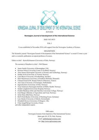
  • 14. 14 Norwegian Journal of development of the International Science No 39/2020 де Ін – індекс екологічної невідповідності існу- ючого використання орних земель екологічно доці- льному; З0 – загальна (облікова) площа ріллі, 0 – площа орнопридатних земель, яка, в свою чергу, може бути вирахувана за формулою: 0 = З0 – (Д + Н), (4) де Д – площа деградованих і малопродуктив- них орних земель, Н – площа земель, схильних до деградації. Тоді перевищення допустимої розораності (П), або відхилення від норми, можна вирахувати за фо- рмулою: П – (Ін – 1)·100 (5) Такі ж розрахунки проведено й щодо інших ви- дів угідь, на підставі чого розроблено шкалу коефі- цієнтів екологічної стійкості агроландшафтів (К). Розроблені нами показники мають знаки (+) або (–), на відміну від таких в О. Г. Топчієва, тому що, за нашими розрахунками, в одних випадках відзнача- лося перевищення показників, в інших – вони менші за норму. На основі багатовимірного аналізу стану зем- лекористування ми провели територіальну дифере- нціацію його структури й екологічного стану в ад- міністративних районах досліджуваного реґіону (рис. 1). Загальна інтегральна екологічна оцінка земле- користування, або екологічна стійкість агроланд- шафту за районами реґіону, яка виражена в балах, виглядає таким чином (табл. 2). Рис. 1. Картограма екологічної стійкості агроландшафтів (у балах) (розроблено автором - Д. Сопов)
  • 15. Norwegian Journal of development of the International Science No 39/2020 15 Таблиця 2 Загальна інтегральна екологічна оцінка землекористування за районами північної частини Луган- ської області (розроблено автором - Д. Сопов) Адміністративні райони Інтегруючі показники стану агроландшафтів Індекс екологічної невідповідності (Ін) Екологічна стійкість агроландшафту (Кс/а) Біловодський 20 2 Білокуракинський 24 3 Кремінський 27 4 Марківський 14 1 Міловський 22 3 Новоайдарський 20 2 Новопсковський 18 2 Сватівський 20 2 Старобільський 22 3 Троїцький 15 1 Висновки. Відповідно до одержаних нами да- них, найбільш уразливими щодо екологічної без- пеки землекористування в лівобережній частині Луганської області виявляються землі Марківсь- кого та Троїцького районів. Відносно безпечним є Кремінський район. Загалом же в усіх районах оче- видною є необхідність реструктуризації системи зе- млекористування з урахуванням як природних, так і соціально-економічних умов. СПИСОК ЛІТЕРАУТРИ: 1. Белоліпський В.О., Бєлослудцева В.М., Другов О.М., Мільчевська Ж.І. Охорона і віднов- лення родючості еродованих ґрунтів. За наук. ред. В.О. Белоліпського. Луганськ. 2012. 116 с. 2. Екологічні і агротехнічні аспекти збере- ження та відновлення родючості сільськогосподар- ських земель Луганської області (методичні реко- мендації) / Белоліпський В.О., Полулях М.М., Хромяк В.М., Наливайко В.В. Х.: ННЦ «ІҐА імені О.Н. Соколовського», 2015. 22 с. 3. Кисельова О.О. Проблеми збереження зе- мельних ресурсів Луганщини. Фізична географія та геоморфологія: Міжвідомчий науковий збірник. Вип. 3(60). К. 2010. С. 239-242. 4. Сопов Д.С. Структура землекористування в Луганській області: формування, сучасний стан, динаміка. Науковий вісник Херсонського держав- ного університету. Серія: географічні науки. 2018. №8. С. 212-217. 5. Сопов Д.С., Кисельов Ю.О. Особливості структури землекористування в Луганському реґі- оні та її екологічне значення. Тези доповідей «GEOFORUM’2019». 24-та Міжнародна науково- технічна конференція, присвячена професійному святу працівників геології, геодезії і картографії України, 10–12 квітня 2019 р., Львів–Брюховичі– Яворів. Львів: Видавництво Львівської політехніки. 2019. С. 53-54. 6. Топчієв О.Г., Шашеро А.М. Застосування методів аналізу великомасштабних планів землеко- ристувань при формуванні реґіональних екомереж. Український географічний журнал. 2012. №3. С. 51- 57. 7. Sopov Dmitry, Sopova Nadiia, Dankeyeva Olha, Chuhaiev Serhii. Natural-historical and ecologi- cal analysis of land resources and land use in Lugansk region. Journal of Geology, Geography and Geoecol- ogy. 2018. №27(2). С. 357-367.
  • 16. 16 Norwegian Journal of development of the International Science No 39/2020 ECONOMIC SCIENCES MAIN CHARACTERISTICS OF THE PEACEBUILDING FUNCTION ECONOMIC SECURITY Blokhin P. Postgraduate student, International University of Finance, Kyiv. 0000-0002-5734-2605 ЗАСАДНИЧІ ХАРАКТЕРИСТИКИ МИРОБУДІВНОЇ ФУНКЦІЇ ЕКОНОМІЧНОЇ БЕЗПЕКИ Блохін П.В. аспірант, Міжнародний університет фінансів, м. Київ 0000-0002-5734-2605 Abstract In the context of Russia's hybrid aggression against Ukraine, the prospects of post-conflict reconciliation and the peculiarities of peace-building in the post-birth space are becoming more pressing issues than ever before. The article generalized existing measures for the restoration of peace, the main spheres of hybrid conflicts in the na- tional security system, investigated and listed the most probable characteristics of the state economic security, to ensure its Economic security. As a result, the study showed that prevention and neutralization of possible threats and economic conflicts will lead to the restoration of the country's national economy. It’s also worth adding, the impact of conflicts on the economic security of the country will lead to the destruction of peacekeeping makes the country in a constant state of finding ways to resolve conflicts. We are convinced, that the negative impact of the hybrid conflict on the economic security of the country and the country's involvement in the long-term hybrid war causes the economy of Ukraine to change and adapt to the realities of today. As a result of the study, the authors analyzed probable conflicts in the economy of the country as a sustained premise of ensuring economic security in post-conflict recovery conditions. Taking into account the problems of economic security, as well as the role of state regulation in the direction of its provision, the issues of choice of methods and instruments for the protection of the national economy in post-conflict conditions are very urgent recovery. At the same time, systematic research and scientif- ically justified recommendations for ensuring the country's economic security should be an important part of such decisions. Анотація В умовах російської гібридної агресії проти України перспективи постконфліктного примирення та особливості миробудівництва на постродянському просторі стають як ніколи актуальними питаннями. В статті узагальнено існуючі заходи до відновлення миру, основні сфери виникнення гібридних конфліктів у системі національної безпеки, досліджені та перераховані найбільш ймовірні характеристики економіч- ної безпеки держави, для забезпечення її миробудівної фукції економічної безпеки. В результаті дослідження встановлено, що попередження і нейтралізація можливих загроз та еконо- мічних конфліктів приведе до відновлення національної економіки країни. Варто також додати, що вплив конфліктів на економічну безпеку країни веде до руйнації миротворчої діяльності, змушує країну перебу- вати в постійному стані пошуку шляхів вирішення конфліктів. Ми переконані, що негативний вплив гіб- ридного конфлікту на економічну безпеку країни та втягування країни в довготривалу гібридну війну зу- мовлює економіку України змінюватись та пристосовуватись до реалів сьогодення. У результаті дослі- дження автори проаналізували ймовірні конфлікти в економіці країни, як стійкої передумови забезпечення економічної безпеки в умовах постконфліктного відновлення. Враховуючи існуючи проблеми економічної безпеки, а також роль державного регулювання у напрямі її забезпечення, надзвичайно актуальними зали- шаються питання вибору методів та інструментів захисту національної економіки в умовах постконфлікт- ного відновлення. У той же час важливою складовою таких рішень повинні стати системні дослідження та науково-обґрунтовані рекомендації щодо забезпечення економічної безпеки країни. Keywords: conflict, peacekeeping, peacebuilding economy, state economic security, peacebuilding complex, national security, characteristics of peacebuilding function Ключові слова: конфлікт, миротворчість, економіка миробудівництва, економічна безпека держави, миробудівництво, національна безпека, характеристики миробудівної функції. Актуальність теми полягає в постійному по- шуку економічних ризиків впливу на економічну безпеку країни. Нав'язаний гібридний конфлікт Ро- сією позбавляє Україну економічного та індустріа- льного зростання, змушує шукати нові шляхи щодо економічної безпеки країни. Складність полягає в тому, що дуже складно виявити засадничі характе- ристики миробудівної функції економічної без- пеки, тому це питання вкрай важливе для України, яка зазнала агресії та потребує більш глибокого ви- вчення. Відсутність в українських реаліях відповід- ного дослідження з виявлення найбільш ймовірних