More Related Content
Similar to CDS ALTA Sample 2014 rev 09-05-14 -Interactive
Similar to CDS ALTA Sample 2014 rev 09-05-14 -Interactive (20)
CDS ALTA Sample 2014 rev 09-05-14 -Interactive
- 1. 0
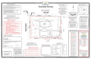
Example Survey
Telephone Number: 111-111-1111
Surveyors Name: Joe Surveyor
Address: 1217 Villa Drive
ofSheet
Approved CDS Surveyor
Thissurveycoordinated,butnotperformed,byCommercialDueDiligenceServices.Surveyobtainedfromandcertifiedtobyalandsurveyorlicensedinthestatepropertyislocated.
To
(name of insured, if known)
(name of lender, if known)
(name of insurer, if known)
(names of others as negotiated with the client):
This is to certify that this map or plat and the survey on which it is based were made in accordance with
the 2011 Minimum Standard Detail Requirements for ALTA/ACSM Land Title Surveys, jointly established
and adopted by ALTA and NSPS, and includes Items of Table A thereof.
The field work was completed on ___________.
Date of Plat or Map:_____
Surveyor's signature
printed name and seal with Registration/License Number
surveyor@firstam.com
1
MANHOLE
FIRE VALVE
UTILITY POLE
TELEPHONE BOX
ELECTRIC METER
HANDICAP PARKING
FOUND IRON ROD (I.R.)
SET IRON ROD (I.R.)
MORE OR LESS
OVERHEAD ELECTRIC LINES
CERTIFIED SURVEY MAP
RAILROAD TRACK
NOT TO SCALE
FENCE
ELECTRIC TRANSFORMER
GAS METER
CONCRETE
CENTERLINE
PROPERTY LINE
The Title Description and Schedule B items hereon are from (Insert Title Company name),
commitment #, Dated (insert date).
©
NOTES CORRESPONDING TO SCHEDULE "B":
TITLE DESCRIPTION
TITLE INFORMATION
SCHEDULE 'B' ITEMS
FLOOD INFORMATION
CEMETERY
STATEMENT OF ENCROACHMENTS
ZONING INFORMATION
SURVEYOR CERTIFICATION
BASIS OF BEARINGS
SURVEYOR'S NOTES
PARKING INFORMATION
LAND AREA
BUILDING AREA
BUILDING HEIGHT
VICINITY MAP
NORTH ARROW / SCALE
SURVEY DRAWING
1
2
3
5
6
7
8
4
10
11
12
13
14
15
16
17
19
TITLE DESCRIPTION
ZONING INFORMATION
BUILDING HEIGHT
TITLE INFORMATION
SCHEDULE 'B' ITEMS
SURVEYOR CERTIFICATION
FLOOD INFORMATION
CEMETERY
POSSIBLE ENCROACHMENTS
LEGEND
BASIS OF BEARING
SURVEYOR'S NOTES
PARKING INFORMATION
LAND AREA
BUILDING AREA
VICINITY MAP
NORTH ARROW / SCALE
CLIENT INFORMATION BOX
SURVEY DRAWING
1
2
3
4
5
6
7
8
9
10
11
12
13
14
15
16
17
18
19
ADJOINER'S ASPHALT ENCROACHES ONTO PROPERTY 3.3'
BUILDING ENCROACHES 0.7' ONTO THE 15' REAR SETBACK LINE.
BUILDING ENCROACHES 0.8' ONTO THE 15' SIDE SETBACK LINE.
METAL BUILDING ENCROACHES 14.2' ONTO THE 15' SIDE SETBACK
LINE.
PERPETUAL EASEMENT FOR RAIL SPUR AND SIDETRACK RECORDED AS
DOCUMENT NO.1143845 IN FAVOR OF VERN HUGININ AND ROSANNE HUGININ.
DOES AFFECT - AS SHOWN
EASEMENT GRANT TO SOUTHWESTERN BELL RECORDED MAY 16, 1978 AS
DOCUMENT NO. 1033562. DOES AFFECT - AS SHOWN
TRUSTEE'S DEED GRANTING LAND AND ALSO AN EASEMENT FOR RAIL SPUR
AND SIDE TRACK OVER PARCEL 1 OF SUBJECT PROPERTY. DOCUMENT
1380440 IN THE FAVOR OF HELGESON INDUSTRIAL PROPERTIES, LLC.
DOES AFFECT - AS SHOWN
AN EASEMENT FOR DRAINAGE AND INCIDENTAL PURPOSES, RECORDED JULY
26, 1967 IN BOOK 6862, PAGE 87 OF OFFICIAL RECORDS.
DOES NOT AFFECT THE SUBJECT PROPERTY.
AN EASEMENT FOR DRAINAGE AND INCIDENTAL PURPOSES, RECORDED JULY
26, 1967 IN BOOK 6862, PAGE 101 OF OFFICIAL RECORDS.
DOES NOT AFFECT THE SUBJECT PROPERTY.
COVENANTS, CONDITIONS AND RESTRICTIONS IN AN INSTRUMENT
RECORDED AUGUST 21, 1967 IN BOOK 6876, PAGE 81 OF OFFICIAL RECORDS.
AFFECTS SUBJECT PROPERTY. CANNOT BE SHOWN BECAUSE IT IS BLANKET
IN NATURE.
1. No observable evidence of earth moving work,
building construction or building additions within
recent months.
2. No observable evidence of changes in street
right of way lines completed, and available from
the controlling jurisdiction and no observable
evidence of recent street or sidewalk construction
or repairs.
3. No observable evidence of site use as a solid
waste dump, sump or sanitary landfill.
4. Property has physical access to Main Street,
a duly dedicated public right of way.
5. All statements within the certification, and other
references located elsewhere hereon, related to:
utilities, improvements, structures, buildings, party
walls, parking, easements, servitudes, and
encroachments are based solely on above ground,
visible evidence, unless another source of
information is specifically referenced hereon.
POINT OF BEGINNING
POINT OF COMMENCEMENT
ALTA/ACSM Land Title Survey
This Work Coordinated By:
Project Name:
CDS Project Number:
Drwn By:
Surveyor
Ref.No:
Aprvd By:
Scale:
Field Date:
Date:
Revision:
Client Ref. No:
Prepared For:
PROJECT ADDRESS
100 MAIN STREET, NORMAN, OK
2011 ALTA SURVEY EXAMPLE
14-01-00001
Thissurveycoordinated,butnotperformed,byCommercialDueDiligenceServices.Surveyobtainedfromandcertifiedtobyalandsurveyorlicensedinthestatepropertyislocated.Thissurveycoordinated,butnotperformed,byCommercialDueDiligenceServices.Surveyobtainedfromandcertifiedtobyalandsurveyorlicensedinthestatepropertyislocated.
This survey coordinated, but not performed, by Commercial Due Diligence Services. Survey obtained from and certified to by a land surveyor licensed in the state property is located. This survey coordinated, but not performed, by Commercial Due Diligence Services. Survey obtained from and certified to by a land surveyor licensed in the state property is located.
This survey coordinated, but not performed, by Commercial Due Diligence Services. Survey obtained from and certified to by a land surveyor licensed in the state property is located. This survey coordinated, but not performed, by Commercial Due Diligence Services. Survey obtained from and certified to by a land surveyor licensed in the state property is located.
The bearing N.89°20'40"W. being the
southerly line of Parcel 1 of Parcel Map No.
12058, Book 146 Pages 47 & 48, records of
the City of Norman, County of Cleveland,
State of Oklahoma, was used as the Basis of
Bearing for this survey. Said Southerly line of
Parcel 1, being shown on said map as
S.89°20'40"E. - 450.00'.
“Zoning Information to be provided by insurer per ALTA
Standards pursuant to Table A item 6b.”
Date:
Revision:
Date:
Revision:
Date:
Revision:
20 40 80
LEGEND9
By graphic plotting only, this property is located in
Zone "X" of the Flood Insurance Rate Map,
Community Panel No. 06071C-8630-F, which bears
an effective date of March 18, 1996 and is NOT in a
special flood hazard area. No field surveying was
performed to determine this Zone and an elevation
certificate may be needed to verify this determination
or apply for a variance from the Federal Emergency
Management Agency.
Zone "X" denotes areas outside the 500 year flood
plain.
There is no visible evidence of cemeteries on the subject property
at the time of survey.
71 Standard Spaces
4 Handicap Spaces
75 Total Parking Spaces
144,000.00 square feet or 3.31 Acres
Bldg 1: 12,918 square feet
Bldg 2: 24,636 square feet
Bldg 1: Height 17.5' feet or 1 Story
Bldg 2: Height 20.7' or 1 Story
ELECTRIC CONTROL CABINET
Key to CDS ALTA Survey
1
18
PROJECT ADDRESS20
20
email: surveyor@firstam.com
This survey prepared in accordance with the "Minimum Standard
Detail Requirements for ALTA/ASCM Land Title Surveys
(Effective February 23, 2011)
LIGHT POLE
THE LAND REFERRED TO HEREON IS SITUATED IN THE CITY OF NORMAN, COUNTY OF CLEVELAND,
STATE OF OKLAHOMA AND IS DESCRIBED AS FOLLOWS:
PARCEL 1 OF PARCEL MAP NO. 12058, IN THE CITY OF NORMAN, AS PER
PLAT RECORDED IN BOOK 146 OF PARCEL MAPS, PAGE(S) 47 AND 48, IN THE OFFICE OF THE COUNTY
RECORDER OF SAID COUNTY, AND AMENDED BY CERTIFICATE OF CORRECTION RECORDED
OCTOBER 24, 1990 AS INSTRUMENT NO. 90-425484, OFFICIAL RECORDS.
PARCEL 1 IS MORE PARTICULARLY DESCRIBED AS FOLLOWS:
COMMENCING AT THE INTERSECTION OF THE CENTERLINE OF BELOIT AVENUE AND MAIN STREET;
THENCE SOUTH 00°39'20" WEST A DISTANCE OF 35.00 FEET:
THENCE SOUTH 89°20'40" EAST A DISTANCE OF 40.00 FEET TO THE POINT OF BEGINNING;
THENCE SOUTH 89°20'40" EAST A DISTANCE OF 450.00 FEET;
THENCE SOUTH 00°39'20" WEST A DISTANCE OF 320.00 FEET;
THENCE NORTH 89°20'40" WEST A DISTANCE OF 450.00 FEET;
THENCE NORTH 00°39'20" EAST A DISTANCE OF 320.00 FEET TO THE POINT AND PLACE OF
BEGINNING, CONTAINING 144,000.00 SQUARE FEET OR 3.31 ACRES.
The land shown in this survey is the same as that described in (Insert Title Company name), Commitment #,
dated (insert date).
MEASURED CALL
RECORD CALL
FLAG POLE
LOCATION OF MEASUREDX
BHL
BUILDING HEIGHT
X
BHL
X
BHL
Toll Free: 888.457.7878
3550 W. Robinson Street, Third Floor
Office: 405.253-2416 - Fax: 405.689-5120
Norman, Oklahoma 73072