SlideShare a Scribd company logo
1 of 1
Download to read offline
The aim of this honours project was to examine the coal seam interburden at Caval Ridge Coal Mine and to determine the likely
depositional environment. This project required the detailed examination of highwalls, thickness and lithology distribution maps,
borehole geophysics, core image logs, and outcrop photos.
Highwall Interburden Sedimentary Study
Depositional Reconstruction of the Late Permian Moranbah Coal
Measures – Caval Ridge Mine, Northern Bowen Basin, Eastern Australia
By Meggie Doran Supervisor: Professor Joan Esterle
Environmental Interpretation:
Pit 20N
Pit 40N
Point of Difference:
Uncertainties in the MCM environmental interpretation centre on a singular bed form featuring large scale dipping beds which
extends from the top to the base of individual bodies. This sedimentary feature could have either been formed by deltaic style
deposition such as a lacustrine delta or subaerial crevasse splay (Flood 1985, Johnson, 1984, Flood and Brady, 1985, Galloway and
Hobday, 1996; Herbert 1997) or alternatively the deposits of laterally accreting point bars of a channel (Fielding et al, 1993 and
Fielding and Alexander 2001 ).
A crevasse splay is distinguished from a channel by a coarsening up gamma ray signature, whilst a channel will be fining up.
The toes of these deposits are also different, where a splay will be finer grained in their toes (due to flow expansion and settling of
muds further from the channel, whilst a channel point bar will have coarser grains in its toes closer to the channel where the flow
velocity of the river is fastest
Crevasse splay vs. Point Bar
Sedimentary Study Caval Ridge
Moranbah Coal Measures:
The Moranbah Coal Measures (MCM) are the oldest coal bearing interval of the non-marine Black Water Group, occurring in the north
western reaches of the Bowen Basin. The MCM are intercalated with laterally continuous coal seams that split and coalesce for some
250 km along the strike of the basin. In the north, near Collinsville, the Moranbah Coal Measures are over 537 m thick; to the
northeast at Kemmis Creek they are 760 m thick and to the south and southwest they thin to less than 20 m over the Comet Ridge and
Capella Block. (Dickens and Malone 1973)
The MCM’s lateral equivalent is the German Creek Formation, a marine unit, which represents a southerly progradation from fluvial
and upper delta plain environments to parlalic or marginal marine environments. The retreat of the palaeoshore to the south has
been attributed to uplift along the eastern margin of the Bowen Basin. As the basin filled the MCM’s environments would have
included extensive shallow lakes and swamps developed in what may have been an internal drainage system (Jensen 1975)
characterised by low velocity rivers and extensive floodplains. A process of cyclic crevasse splay accretion and periodic channel
avulsion, accompanied by synchronous differential compaction of thick underlying peats to form complex coal seam splitting patterns
(caused by thermal subsidence and foreland loading ) is thought to be the main mechanism of sediment accumulation in the MCM
(Johnson 1990).
Significant findings have shown that the massive sandstone channels show an increase in thickness and
width up-sequence. The two channels in each Pit 10N and 12N have a linear trend in this increase supporting
the interpretation of a prograding environment,
Recently, environments characterised by multiple channels radiating from an apex synchronously have been
characterised as part of a larger system known as a distributive fluvial system. These deposits now are
considered to make up a large proportion of the rock record (Weissmann et al 2010), their scale being so
large, that they are usually only identified by their prograding signature. Distributive fluvial systems (or
DFS’s) develop by repeated avulsions (Nichols and Fisher, 2007) and will experience an overall decrease in
channel width and depth downstream and an increase in the proportion of floodplain area relative to
channel area . DFS deposits have been likened to alluvial fan or ‘megafan’ deposits and are believed to form
at the entry point of rivers into sedimentary basins. Their radial form although superficially comparable to a
delta deposit (both coarsening upward sequences) will always have numerous main channels that are active
at the same time compared to the one active channel of a delta which forms lobes which get abandoned
before avulsing to new channel pathways.
Prograding massive channels up-sequence in Pit 10N and 12N
Nichols and Fisher, 2007
A DFS may have multiple types of channel forms (from meandering to braided) and depending on the main type of channels and the number of threads will determine the types of deposits
it will produce and preserve. The illustration below depicts the difference to a DFS morphology comparing highest energy braided river threads to meandering rivers. Generally all distal DFS
facies commonly consist of wetland and hydromorphic floodplain deposits that encase single channels although braided systems will have a well-drained floodplain and meandering will have
standing water bodies and abandoned channel fills. Medial deposits show larger channel belt size and relatively well-drained soils, indicating a deeper water table. Proximal deposits of DFS
display larger channel belts that are amalgamated with limited or no soil development across the apex of the DFS and can show greater channel amalgamation. Proximal deposits will extend
further in braided forms of DFS. The resulting vertical sedimentary succession from progradation will display a general coarsening-upward succession of facies.
D05 Interval
Dysart Lower
D47 Interval
Dysart Upper
H00 Interval
Harrow Creek Lower
Massive sandstone channel three
Massive sandstone channel four
Highwall Observations:
Lithology Distribution Maps - Progression Up-sequence of Interburden showing modelled facies of sandstone and mudstone that assign to a block model. Sandstone may be over-estimated.
Caval Ridge Coal Seam Schematic:
Borehole Geophysics:
Core Imagery:
A total of five facies were
identified: channels,
peatlands, floodplain,
crevasse splay, lake
deposits.
Further results are due Nov.
Modern Analog:
The Permian environment is viewed by many to have been analogous to modern day cold climate coals forming in shoestring bogs in
tundra areas of north western Siberia (Ob River) (Retallak, 1999) or the lowland river basins of Canada such as the Mackenzie River.
These environments are forming in high latitudes, similar to the Permian palaeoclimate which the Bowen Basin formed in, and are also
characterised by extensive peatmires, marsh systems, channels, floodplain and lake environments. A very low gradient, stable
floodplain is likely of the Permian Moranbah Coal Measures where it could episodically be traversed by anastomosing rivers which
drained southwards into a marine basin. Recently the Ob River Siberia, Mackenzie River Canada and Yukon River Alaska, have been
suggested to be more accurate analogues due to their high latitude and tectonically active setting, (Bowen Basin formed in an active
foreland basin margin) but studies comparing them are limited.
b. Mackenzie River Delta, North West Canada (GoogleEarth Pro.)a. Environment envisaged: low lying channels, splays, floodplain and
swamps of upper delta plain
Meggie.D, 2015
The quality and resolution of the laser scan imagery was greatly impacted by the position of sun at the time of field-work and were used in combination
with photos to assist with interpretation and overall geometries within the Pits.
It is interpreted that the environmental system analysed may in fact be part of a much larger scale system such as the DFS, which is similarly
characterised by coarsening up, prograding features where channels become wider and thicker up-sequence and the proportion of floodplain area
relative to channel area is greater down-sequence. A larger study area would be needed to support this interpretation.
a.
b.
Pit 10N
Pit 11N
Pit 12N
Location:
Caval Ridge is currently operating in two pits: Horse Pit and Heyford Pit. These
pits are accessed by a series of ramps named 10N to 50N. The two pits are
mining stratigraphically distinct coal intervals with Horse Pit mining the older
Dysart seams and Heyford Pit mining the younger Harrow Creek coal seams.
N
Geological map courtesy of BMA, 2015
c.
c. d.
a.
b.
b.
d.
b.
a.
a.
a.
a.
d.
c.
c.c.

More Related Content

What's hot

Geomorphology and its application to hydrogeology
Geomorphology and its application to hydrogeologyGeomorphology and its application to hydrogeology
Geomorphology and its application to hydrogeologysuchi4
 
Geological work of natural agencies like rivers
Geological work of natural agencies like  riversGeological work of natural agencies like  rivers
Geological work of natural agencies like riversRAMPRASAD KUMAWAT
 
Drainage basin morphometry
Drainage basin morphometry Drainage basin morphometry
Drainage basin morphometry Kamal Shahi
 
Karst topography
Karst topographyKarst topography
Karst topographyShivam Jain
 
Easc116 rivers
Easc116 riversEasc116 rivers
Easc116 riverscresnick
 
TSherman Strat Poster
TSherman Strat PosterTSherman Strat Poster
TSherman Strat PosterTrent Sherman
 
River Channel Processes & Landforms
River Channel Processes & LandformsRiver Channel Processes & Landforms
River Channel Processes & LandformsMalia Damit
 
Impact of A Paleochannel on Hydrogeochemistry of A Quaternary Aquifer: Case S...
Impact of A Paleochannel on Hydrogeochemistry of A Quaternary Aquifer: Case S...Impact of A Paleochannel on Hydrogeochemistry of A Quaternary Aquifer: Case S...
Impact of A Paleochannel on Hydrogeochemistry of A Quaternary Aquifer: Case S...QUESTJOURNAL
 
Fluvial depositional landform geomorphology
Fluvial depositional  landform geomorphologyFluvial depositional  landform geomorphology
Fluvial depositional landform geomorphologyShivam Jain
 
Drainage pattern and their significance
Drainage pattern and their significanceDrainage pattern and their significance
Drainage pattern and their significanceAvinashAvi110
 

What's hot (20)

Hydro geology slides 11 to 20
Hydro geology slides 11 to 20Hydro geology slides 11 to 20
Hydro geology slides 11 to 20
 
GSA Poster 10.26.15
GSA Poster 10.26.15GSA Poster 10.26.15
GSA Poster 10.26.15
 
Geomorphology and its application to hydrogeology
Geomorphology and its application to hydrogeologyGeomorphology and its application to hydrogeology
Geomorphology and its application to hydrogeology
 
Geological work of natural agencies like rivers
Geological work of natural agencies like  riversGeological work of natural agencies like  rivers
Geological work of natural agencies like rivers
 
Hydro geology slides 21 to 30
Hydro geology slides 21 to 30Hydro geology slides 21 to 30
Hydro geology slides 21 to 30
 
Beeville MLT_Groundwater 101_Marcus Gary
Beeville MLT_Groundwater 101_Marcus GaryBeeville MLT_Groundwater 101_Marcus Gary
Beeville MLT_Groundwater 101_Marcus Gary
 
The work of rivers
The work of riversThe work of rivers
The work of rivers
 
Drainage basin morphometry
Drainage basin morphometry Drainage basin morphometry
Drainage basin morphometry
 
Poster
PosterPoster
Poster
 
Fluvial Systems - General
Fluvial Systems - GeneralFluvial Systems - General
Fluvial Systems - General
 
Karst topography
Karst topographyKarst topography
Karst topography
 
Easc116 rivers
Easc116 riversEasc116 rivers
Easc116 rivers
 
Amarillo MLT_Hydrogeology 101_Ken Rainwater
Amarillo MLT_Hydrogeology 101_Ken RainwaterAmarillo MLT_Hydrogeology 101_Ken Rainwater
Amarillo MLT_Hydrogeology 101_Ken Rainwater
 
TSherman Strat Poster
TSherman Strat PosterTSherman Strat Poster
TSherman Strat Poster
 
Syn rift
Syn riftSyn rift
Syn rift
 
River Channel Processes & Landforms
River Channel Processes & LandformsRiver Channel Processes & Landforms
River Channel Processes & Landforms
 
Turbidity
TurbidityTurbidity
Turbidity
 
Impact of A Paleochannel on Hydrogeochemistry of A Quaternary Aquifer: Case S...
Impact of A Paleochannel on Hydrogeochemistry of A Quaternary Aquifer: Case S...Impact of A Paleochannel on Hydrogeochemistry of A Quaternary Aquifer: Case S...
Impact of A Paleochannel on Hydrogeochemistry of A Quaternary Aquifer: Case S...
 
Fluvial depositional landform geomorphology
Fluvial depositional  landform geomorphologyFluvial depositional  landform geomorphology
Fluvial depositional landform geomorphology
 
Drainage pattern and their significance
Drainage pattern and their significanceDrainage pattern and their significance
Drainage pattern and their significance
 

Viewers also liked

Arias colombo-lucero
Arias colombo-luceroArias colombo-lucero
Arias colombo-luceroMaru Arias
 
Educación y nuevas tecnologías
Educación y nuevas tecnologíasEducación y nuevas tecnologías
Educación y nuevas tecnologíasMaru Arias
 
Tang 06 assumptions with equilibrium 2
Tang 06   assumptions with equilibrium 2Tang 06   assumptions with equilibrium 2
Tang 06 assumptions with equilibrium 2mrtangextrahelp
 
Lecture 4 beam design and load combination
Lecture 4 beam design and load combinationLecture 4 beam design and load combination
Lecture 4 beam design and load combinationDr. H.M.A. Mahzuz
 
Lecture 6 steel building design considering earthquake and wind load
Lecture 6 steel building design considering earthquake and wind loadLecture 6 steel building design considering earthquake and wind load
Lecture 6 steel building design considering earthquake and wind loadDr. H.M.A. Mahzuz
 
Lecture 5 rcc building design considering earthquake and wind load
Lecture 5 rcc building design considering earthquake and wind loadLecture 5 rcc building design considering earthquake and wind load
Lecture 5 rcc building design considering earthquake and wind loadDr. H.M.A. Mahzuz
 
Diapositivas gestion ramiro priale
Diapositivas gestion ramiro prialeDiapositivas gestion ramiro priale
Diapositivas gestion ramiro prialeClub Girasoles
 
Androidオススメライブラリ紹介
Androidオススメライブラリ紹介Androidオススメライブラリ紹介
Androidオススメライブラリ紹介阪田 祐宇
 

Viewers also liked (14)

Ice2012
Ice2012Ice2012
Ice2012
 
Concord Tobaco
Concord TobacoConcord Tobaco
Concord Tobaco
 
The Formation of new concepts of scientific research in Psychology and Pedago...
The Formation of new concepts of scientific research in Psychology and Pedago...The Formation of new concepts of scientific research in Psychology and Pedago...
The Formation of new concepts of scientific research in Psychology and Pedago...
 
Bemutató1
Bemutató1Bemutató1
Bemutató1
 
Portugues
PortuguesPortugues
Portugues
 
Arias colombo-lucero
Arias colombo-luceroArias colombo-lucero
Arias colombo-lucero
 
Educación y nuevas tecnologías
Educación y nuevas tecnologíasEducación y nuevas tecnologías
Educación y nuevas tecnologías
 
Tang 06 assumptions with equilibrium 2
Tang 06   assumptions with equilibrium 2Tang 06   assumptions with equilibrium 2
Tang 06 assumptions with equilibrium 2
 
Lecture 4 beam design and load combination
Lecture 4 beam design and load combinationLecture 4 beam design and load combination
Lecture 4 beam design and load combination
 
Tang 03 ph & poh 2
Tang 03   ph & poh 2Tang 03   ph & poh 2
Tang 03 ph & poh 2
 
Lecture 6 steel building design considering earthquake and wind load
Lecture 6 steel building design considering earthquake and wind loadLecture 6 steel building design considering earthquake and wind load
Lecture 6 steel building design considering earthquake and wind load
 
Lecture 5 rcc building design considering earthquake and wind load
Lecture 5 rcc building design considering earthquake and wind loadLecture 5 rcc building design considering earthquake and wind load
Lecture 5 rcc building design considering earthquake and wind load
 
Diapositivas gestion ramiro priale
Diapositivas gestion ramiro prialeDiapositivas gestion ramiro priale
Diapositivas gestion ramiro priale
 
Androidオススメライブラリ紹介
Androidオススメライブラリ紹介Androidオススメライブラリ紹介
Androidオススメライブラリ紹介
 

Similar to thesis summary bowen basin symposium poster meggie doran

sequence characteristic.pptx
sequence characteristic.pptxsequence characteristic.pptx
sequence characteristic.pptxSaadTaman
 
Distinguishing gas bearing sandstone reservoirs within mixed siliciclastic-ca...
Distinguishing gas bearing sandstone reservoirs within mixed siliciclastic-ca...Distinguishing gas bearing sandstone reservoirs within mixed siliciclastic-ca...
Distinguishing gas bearing sandstone reservoirs within mixed siliciclastic-ca...Ahmed Hafez
 
conglomerate facies.pptx
conglomerate facies.pptxconglomerate facies.pptx
conglomerate facies.pptxSaadTaman
 
The Chilcotin Basalts: implications for mineral exploration
The Chilcotin Basalts: implications for mineral explorationThe Chilcotin Basalts: implications for mineral exploration
The Chilcotin Basalts: implications for mineral explorationGraham Andrews
 
Hadlari etal. 2006 baker lake rift basin sedimentology
Hadlari etal. 2006 baker lake rift basin sedimentologyHadlari etal. 2006 baker lake rift basin sedimentology
Hadlari etal. 2006 baker lake rift basin sedimentologyrad8
 
A seminar on basin evolution and tectonics
A seminar on basin evolution and tectonicsA seminar on basin evolution and tectonics
A seminar on basin evolution and tectonicsPramoda Raj
 
Delta Lithologic Facies Classification.pptx
Delta Lithologic Facies Classification.pptxDelta Lithologic Facies Classification.pptx
Delta Lithologic Facies Classification.pptxSaadTaman
 
Mudstone facies.pptx
Mudstone facies.pptxMudstone facies.pptx
Mudstone facies.pptxSaadTaman
 
Source-Reservoir and Delta Trap.pptx
Source-Reservoir and Delta Trap.pptxSource-Reservoir and Delta Trap.pptx
Source-Reservoir and Delta Trap.pptxSaadTaman
 
The Occurrence of Sedimentary Rock
The Occurrence of Sedimentary RockThe Occurrence of Sedimentary Rock
The Occurrence of Sedimentary RockCharles Jojo Besitan
 
Sedimentary basin classification
Sedimentary basin classificationSedimentary basin classification
Sedimentary basin classificationPaul Ajith Ajang
 
Geomorphology - irrigation on riverine plains
Geomorphology - irrigation on riverine plainsGeomorphology - irrigation on riverine plains
Geomorphology - irrigation on riverine plainsPramoda Raj
 
Advanced petrology ( tectonic and sedimetation).pptx
Advanced petrology ( tectonic and sedimetation).pptxAdvanced petrology ( tectonic and sedimetation).pptx
Advanced petrology ( tectonic and sedimetation).pptxAnnamalai University
 
Fan delta front.pptx
Fan delta front.pptxFan delta front.pptx
Fan delta front.pptxSaadTaman
 
Groundwater Exploration in Tennessee's Karst Terrane
Groundwater Exploration in Tennessee's Karst TerraneGroundwater Exploration in Tennessee's Karst Terrane
Groundwater Exploration in Tennessee's Karst TerraneThomas Ballard, PG, CHG
 
Basin margin
Basin marginBasin margin
Basin marginWajid09
 

Similar to thesis summary bowen basin symposium poster meggie doran (20)

Sedimentary basins
Sedimentary basinsSedimentary basins
Sedimentary basins
 
sequence characteristic.pptx
sequence characteristic.pptxsequence characteristic.pptx
sequence characteristic.pptx
 
Distinguishing gas bearing sandstone reservoirs within mixed siliciclastic-ca...
Distinguishing gas bearing sandstone reservoirs within mixed siliciclastic-ca...Distinguishing gas bearing sandstone reservoirs within mixed siliciclastic-ca...
Distinguishing gas bearing sandstone reservoirs within mixed siliciclastic-ca...
 
Class materials 1 (4).ppt
Class  materials 1 (4).pptClass  materials 1 (4).ppt
Class materials 1 (4).ppt
 
conglomerate facies.pptx
conglomerate facies.pptxconglomerate facies.pptx
conglomerate facies.pptx
 
The Chilcotin Basalts: implications for mineral exploration
The Chilcotin Basalts: implications for mineral explorationThe Chilcotin Basalts: implications for mineral exploration
The Chilcotin Basalts: implications for mineral exploration
 
Hadlari etal. 2006 baker lake rift basin sedimentology
Hadlari etal. 2006 baker lake rift basin sedimentologyHadlari etal. 2006 baker lake rift basin sedimentology
Hadlari etal. 2006 baker lake rift basin sedimentology
 
A seminar on basin evolution and tectonics
A seminar on basin evolution and tectonicsA seminar on basin evolution and tectonics
A seminar on basin evolution and tectonics
 
Delta Lithologic Facies Classification.pptx
Delta Lithologic Facies Classification.pptxDelta Lithologic Facies Classification.pptx
Delta Lithologic Facies Classification.pptx
 
Mudstone facies.pptx
Mudstone facies.pptxMudstone facies.pptx
Mudstone facies.pptx
 
Source-Reservoir and Delta Trap.pptx
Source-Reservoir and Delta Trap.pptxSource-Reservoir and Delta Trap.pptx
Source-Reservoir and Delta Trap.pptx
 
The Occurrence of Sedimentary Rock
The Occurrence of Sedimentary RockThe Occurrence of Sedimentary Rock
The Occurrence of Sedimentary Rock
 
Deltas by universty of sargodha,pakistan
Deltas by universty of sargodha,pakistanDeltas by universty of sargodha,pakistan
Deltas by universty of sargodha,pakistan
 
Dissertation
DissertationDissertation
Dissertation
 
Sedimentary basin classification
Sedimentary basin classificationSedimentary basin classification
Sedimentary basin classification
 
Geomorphology - irrigation on riverine plains
Geomorphology - irrigation on riverine plainsGeomorphology - irrigation on riverine plains
Geomorphology - irrigation on riverine plains
 
Advanced petrology ( tectonic and sedimetation).pptx
Advanced petrology ( tectonic and sedimetation).pptxAdvanced petrology ( tectonic and sedimetation).pptx
Advanced petrology ( tectonic and sedimetation).pptx
 
Fan delta front.pptx
Fan delta front.pptxFan delta front.pptx
Fan delta front.pptx
 
Groundwater Exploration in Tennessee's Karst Terrane
Groundwater Exploration in Tennessee's Karst TerraneGroundwater Exploration in Tennessee's Karst Terrane
Groundwater Exploration in Tennessee's Karst Terrane
 
Basin margin
Basin marginBasin margin
Basin margin
 

thesis summary bowen basin symposium poster meggie doran

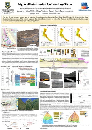
  • 1. The aim of this honours project was to examine the coal seam interburden at Caval Ridge Coal Mine and to determine the likely depositional environment. This project required the detailed examination of highwalls, thickness and lithology distribution maps, borehole geophysics, core image logs, and outcrop photos. Highwall Interburden Sedimentary Study Depositional Reconstruction of the Late Permian Moranbah Coal Measures – Caval Ridge Mine, Northern Bowen Basin, Eastern Australia By Meggie Doran Supervisor: Professor Joan Esterle Environmental Interpretation: Pit 20N Pit 40N Point of Difference: Uncertainties in the MCM environmental interpretation centre on a singular bed form featuring large scale dipping beds which extends from the top to the base of individual bodies. This sedimentary feature could have either been formed by deltaic style deposition such as a lacustrine delta or subaerial crevasse splay (Flood 1985, Johnson, 1984, Flood and Brady, 1985, Galloway and Hobday, 1996; Herbert 1997) or alternatively the deposits of laterally accreting point bars of a channel (Fielding et al, 1993 and Fielding and Alexander 2001 ). A crevasse splay is distinguished from a channel by a coarsening up gamma ray signature, whilst a channel will be fining up. The toes of these deposits are also different, where a splay will be finer grained in their toes (due to flow expansion and settling of muds further from the channel, whilst a channel point bar will have coarser grains in its toes closer to the channel where the flow velocity of the river is fastest Crevasse splay vs. Point Bar Sedimentary Study Caval Ridge Moranbah Coal Measures: The Moranbah Coal Measures (MCM) are the oldest coal bearing interval of the non-marine Black Water Group, occurring in the north western reaches of the Bowen Basin. The MCM are intercalated with laterally continuous coal seams that split and coalesce for some 250 km along the strike of the basin. In the north, near Collinsville, the Moranbah Coal Measures are over 537 m thick; to the northeast at Kemmis Creek they are 760 m thick and to the south and southwest they thin to less than 20 m over the Comet Ridge and Capella Block. (Dickens and Malone 1973) The MCM’s lateral equivalent is the German Creek Formation, a marine unit, which represents a southerly progradation from fluvial and upper delta plain environments to parlalic or marginal marine environments. The retreat of the palaeoshore to the south has been attributed to uplift along the eastern margin of the Bowen Basin. As the basin filled the MCM’s environments would have included extensive shallow lakes and swamps developed in what may have been an internal drainage system (Jensen 1975) characterised by low velocity rivers and extensive floodplains. A process of cyclic crevasse splay accretion and periodic channel avulsion, accompanied by synchronous differential compaction of thick underlying peats to form complex coal seam splitting patterns (caused by thermal subsidence and foreland loading ) is thought to be the main mechanism of sediment accumulation in the MCM (Johnson 1990). Significant findings have shown that the massive sandstone channels show an increase in thickness and width up-sequence. The two channels in each Pit 10N and 12N have a linear trend in this increase supporting the interpretation of a prograding environment, Recently, environments characterised by multiple channels radiating from an apex synchronously have been characterised as part of a larger system known as a distributive fluvial system. These deposits now are considered to make up a large proportion of the rock record (Weissmann et al 2010), their scale being so large, that they are usually only identified by their prograding signature. Distributive fluvial systems (or DFS’s) develop by repeated avulsions (Nichols and Fisher, 2007) and will experience an overall decrease in channel width and depth downstream and an increase in the proportion of floodplain area relative to channel area . DFS deposits have been likened to alluvial fan or ‘megafan’ deposits and are believed to form at the entry point of rivers into sedimentary basins. Their radial form although superficially comparable to a delta deposit (both coarsening upward sequences) will always have numerous main channels that are active at the same time compared to the one active channel of a delta which forms lobes which get abandoned before avulsing to new channel pathways. Prograding massive channels up-sequence in Pit 10N and 12N Nichols and Fisher, 2007 A DFS may have multiple types of channel forms (from meandering to braided) and depending on the main type of channels and the number of threads will determine the types of deposits it will produce and preserve. The illustration below depicts the difference to a DFS morphology comparing highest energy braided river threads to meandering rivers. Generally all distal DFS facies commonly consist of wetland and hydromorphic floodplain deposits that encase single channels although braided systems will have a well-drained floodplain and meandering will have standing water bodies and abandoned channel fills. Medial deposits show larger channel belt size and relatively well-drained soils, indicating a deeper water table. Proximal deposits of DFS display larger channel belts that are amalgamated with limited or no soil development across the apex of the DFS and can show greater channel amalgamation. Proximal deposits will extend further in braided forms of DFS. The resulting vertical sedimentary succession from progradation will display a general coarsening-upward succession of facies. D05 Interval Dysart Lower D47 Interval Dysart Upper H00 Interval Harrow Creek Lower Massive sandstone channel three Massive sandstone channel four Highwall Observations: Lithology Distribution Maps - Progression Up-sequence of Interburden showing modelled facies of sandstone and mudstone that assign to a block model. Sandstone may be over-estimated. Caval Ridge Coal Seam Schematic: Borehole Geophysics: Core Imagery: A total of five facies were identified: channels, peatlands, floodplain, crevasse splay, lake deposits. Further results are due Nov. Modern Analog: The Permian environment is viewed by many to have been analogous to modern day cold climate coals forming in shoestring bogs in tundra areas of north western Siberia (Ob River) (Retallak, 1999) or the lowland river basins of Canada such as the Mackenzie River. These environments are forming in high latitudes, similar to the Permian palaeoclimate which the Bowen Basin formed in, and are also characterised by extensive peatmires, marsh systems, channels, floodplain and lake environments. A very low gradient, stable floodplain is likely of the Permian Moranbah Coal Measures where it could episodically be traversed by anastomosing rivers which drained southwards into a marine basin. Recently the Ob River Siberia, Mackenzie River Canada and Yukon River Alaska, have been suggested to be more accurate analogues due to their high latitude and tectonically active setting, (Bowen Basin formed in an active foreland basin margin) but studies comparing them are limited. b. Mackenzie River Delta, North West Canada (GoogleEarth Pro.)a. Environment envisaged: low lying channels, splays, floodplain and swamps of upper delta plain Meggie.D, 2015 The quality and resolution of the laser scan imagery was greatly impacted by the position of sun at the time of field-work and were used in combination with photos to assist with interpretation and overall geometries within the Pits. It is interpreted that the environmental system analysed may in fact be part of a much larger scale system such as the DFS, which is similarly characterised by coarsening up, prograding features where channels become wider and thicker up-sequence and the proportion of floodplain area relative to channel area is greater down-sequence. A larger study area would be needed to support this interpretation. a. b. Pit 10N Pit 11N Pit 12N Location: Caval Ridge is currently operating in two pits: Horse Pit and Heyford Pit. These pits are accessed by a series of ramps named 10N to 50N. The two pits are mining stratigraphically distinct coal intervals with Horse Pit mining the older Dysart seams and Heyford Pit mining the younger Harrow Creek coal seams. N Geological map courtesy of BMA, 2015 c. c. d. a. b. b. d. b. a. a. a. a. d. c. c.c.