MaxSea TimeZero Sailing Range brochure in English
•
1 like•282 views

MaxSea TimeZero is an all-in-one marine navigation software that offers intuitive 3D chart display, photo fusion capabilities, worldwide chart coverage, built-in AIS/ARPA functions for collision avoidance, optional routing module, compatibility with Furuno NavNet systems, and free weather forecast access. It provides a seamless 2D to 3D chart experience with no redraw time and allows overlaying of satellite photos on charts.

Recommended
Recommended
More Related Content
Viewers also liked
Viewers also liked (13)
Similar to MaxSea TimeZero Sailing Range brochure in English
Similar to MaxSea TimeZero Sailing Range brochure in English (20)
Recently uploaded
Recently uploaded (20)
MaxSea TimeZero Sailing Range brochure in English
- 1. Strength and Features • All in one solution: software + charts + data • Fast and smooth chart engine with 3D display • Intuitive, user-friendly interface • PhotoFusion: Charts, 3D data and satellite photos are combined • A worldwide online catalogue including a huge choice of formats: *mm3d Raster *mm3d Vector by Jeppesen *mm3d Vector Datacore by • Routes & Waypoints management • Free weather forecast access and display • Built-in AIS/ARPA function • Worldwide tide database • Optional modules available: Routing, Furuno NavNet 3D compatibility, etc. • Optional data available: HR European Tidal Currents & HR Satellite Photos • Free services at My MaxSea and Active Captain access (receive advice and information, share your passion and experiences, etc.) MaxSea International - Technopole Izarbel - allée Théodore Monod - 64210 Bidart - France t/ +33 559 43 81 00 - f/ +33 559 43 81 01 - info@maxsea.fr www.maxsea.com MapMedia is a trade mark of the company MapMedia SAS. MaxSea is a trade mark of the company MaxSea International SAS. Navionics is a trade mark of the company Navionics SpA. C-MAP is a trade mark of the company JEPPESEN®. MaxSea TimeZero The most intuitive navigation software ever! MaxSeaInternational/Photos:JacquesVAPILLON-MaxSea/Noncontractualdocument/EN-MXTZ-BrochureSailing-102012 • 1h Training on a specific feature or topic • 3h Handover • Software and Chart Installation • GPS USB connection • PC Troubleshooting Our support service offers dedicated remote training/assistance sessions: Schedule a remote session now or ask for more information at support@maxsea.fr Complementary Assistance and Training MaxSea International www.maxsea.com info@maxsea.fr Today, as the world leader in marine navigation software, MaxSea is available in 13 languages, and equips 40,000 vessels worldwide; from sailing yachts to super yachts, from tugboats to tankers. ThebestprofessionalskippersintheworldsuchasMichelDesjoyeaux,SamanthaDavies, Franck Cammas, Loïck Peyron and Philippe Poupon all trust MaxSea’s expertise. Seamless and Continuous Chart Display With TimeZero technology, MaxSea software has a high-performance and innovative 2D/3D chart engine. This enhanced marine chart display allows seamless pan and zoom with no redraw time. PhotoFusion PhotoFusion is a built-in function in all MaxSea TimeZero products, and allows an amazing execution and display speed of marine chart data by fusing the satellite photo directly to your chart. With PhotoFusion, the outstanding zoom effect will give you the impression of diving right into your charts. Worldwide Chart Catalogue Through MapMedia, a subsidiary specialized in digital cartography and Raster data treatment, MaxSea offers more than 6,000 nautical charts from around the world, including Vector charts from Jeppesen and Navionics data. Full 3D Environment MaxSea TimeZero has a revolutionary user-friendly interface that allows you to easily switch from a traditional 2D display to a 3D chart in one click. TimeZero technology and its 3D environment will change the way you navigate.
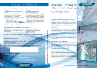
- 2. 4 2 1 3 6 5 7 Features 1/ Computers equipped with MaxSea TimeZero 2/ Instruments 3/ Furuno NavNet 4/ Sounder 5/ Radar antenna 6/ AIS Receiver 7/ GPS antenna MaxSea TimeZero’s AIS/ARPA function enhances your collisions-avoidance abilities. With the built-in AIS/ARPA functions and a connected AIS receiver, MaxSea TimeZero displays AIS targets on the chart, along with the course, speed and immediate collision risks. With MaxSea TimeZero, navigate safely with total peace of mind! The MaxSea TimeZero Routing Module enables you to calculate the optimal sailing route based on weather forecasts, currents, wind polars of your boat and your own navigation style. With this new version of MaxSea, the Routing Module goes even further, adding the following features: one click comparison between several routes, option to pass a waypoint, waves are now used for routing computation along with wind and currents. Developed with Mer Agitée, Michel Desjoyeaux’s racing team, MaxSea’s Routing is a powerful sailing performance tool for both amateurs and professionals alike. www.maxsea.com - info@maxsea.fr NavNet compatibility MaxSea TimeZero enables the download and display of weather forecast in standard grib format directly through the MaxSea Weather Wizard. This weather tool is completely free and easy to use, giving you unlimited access to worldwide weather forecast 24 hours a day. Select a geographic coverage, data type, period of time and choose how to receive the file. MaxSea TimeZero can provide up to 16 days of weather forecast! Built-in AIS/ARPA Function Routing Module Free weather forecast service Furuno Electric Company, one of the world’s leading marine electronics manufacturers, has partnered with MaxSea International to integrate TimeZero Technology with their NavNet system, allowing complete compatibility. Connect directly to any Furuno NavNet system via a simple Ethernet connection. Users can easily access and control valuable information from their NavNet network, such as Radar Overlay, Waypoints and Routes directly on their PC.