Romsdalen Valley Norway, River Dart England, Mississippi Delta USA
•Download as DOCX, PDF•
2 likes•134 views

The document summarizes information about the Romsdalen Valley in Norway. It is a 60-kilometer long V-shaped valley that runs through two counties. The Rauma River flows through the bottom of the valley and eventually empties into Romsdalsfjorden. Large debris and material regularly flow down the river, making it ideal for white water rafting. This is caused by rocks falling from the steep valley sides due to weathering and freeze-thaw cycles that cause cracking and crumbling of the cliff faces.

Recommended
More Related Content
What's hot
Similar to Romsdalen Valley Norway, River Dart England, Mississippi Delta USA
Similar to Romsdalen Valley Norway, River Dart England, Mississippi Delta USA (20)
More from The Axe Valley Community College
More from The Axe Valley Community College (20)
Recently uploaded
Recently uploaded (20)
Romsdalen Valley Norway, River Dart England, Mississippi Delta USA
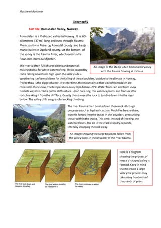
- 1. MatthewMortimer Geography Fact file: Romsdalen Valley, Norway Romsdalen is a V-shaped valley in Norway. It is 60- kilometres (37 mi) long and runs through Rauma Municipality in Møre og Romsdal county and Lesja Municipality in Oppland county. At the bottom of the valley is the Rauma River, which eventually flows into Romsdalsfjorden. The riveris oftenfull of large debrisandmaterial, makingitideal forwhite waterrafting. Thisiscausedby rocks fallingdownfromhighuponthe valleysides. Weatheringisoftentoblame forthe fallingof these boulders,butdue tothe climate inNorway, freeze thawisthe biggestfactor.Inwintertime,the mountainseitherside of Romsdalenare coveredinthicksnow.The temperature easilydipsbelow -25°C.Waterfromrain and fromsnow findsitswayintocracks on the cliff surface.Uponfreezing,thiswaterexpands,andfracturesthe rock, breakingitfromthe cliff face.Gravitythencausesthe rock to tumble downintothe river below. The valleycliffsare greatforrockingclimbing. The riverRauma thenbreaksdownthese rocksthrough processessuchas hydraulicaction.Muchlike freeze-thaw, wateris forcedintothe cracks inthe boulders,pressurising the air withinthe cracks.Thistime,insteadof freezing,the waterretreats.The air inthe cracks rapidlyexpands, litterallysnappingthe rockaway. An image of the steep sided Romsdalen Valley with the Rauma flowing at its base. An image showing the large boulders fallen from the valleysidesinthe icywaterof the river Rauma. Here is a diagram showingthe processof how a V-shapedvalleyis formed.Keepinmind that to create a large valleythe processmay take many hundredsof thousandsof years.
- 2. MatthewMortimer Area of erosion Meander meets River finds original path and cuts off Oxbow lake Fact File: River Dart Meanders The river Dart features several meanders. The ones featured here are South of Totnes in South Devon, England. The River Dart is a river in Devon, England which rises high on Dartmoor, and releases to the sea at Dartmouth. As the river erodes laterally, to the right side then the left side, it forms large bends, and then horseshoe-like loops called meanders. This is what has happened to the river dart. The river Dart is extremely popular for canoeing and also kayaking. Also, the inner curve of the meander makes for an ideal mini headland for keen anglers looking to catch the abundant river Salmon. The outside of the bendsiswhere the velocityof the wateris at its highest,causing erosionthrough processessuchas abrasion. On the inside of the curvesthe velocityisalotslower. Insteadof erosion,we see deposition.Materialscarriedin the riverby processessuchassolutionare deposited, buildinguplandascan be seeninthe image above. A meandercan erode a bendso much itbreaks throughintothe nextcurve.This redirectsthe river straight,andcan leave anOxbowlake. The piece of landon the image isthinning and isin dangerof this. One erosional processwearingawaythe riverbanks couldbe Abrasion.Thisiswhen rockscarriedalongby the riverweardownthe riverbedand banksas theyhit and travel alongthem.Thiswearingdownof the bankas statedbefore canbreakthroughto create an Oxbow lake,asshowninthe diagrambelow.
- 3. MatthewMortimer An image showingthe banksof siltdepositedasthe riverdumps itsload.Note the brown,murky water.Thisclearlyshowsthe processesof transportation,such as suspension,are takingplace. Fact File: Mississippi River Delta The Mississippi River Delta region is a 3-million-acre (12,000 km²) area of land that stretches from Vermillion Bay east to the Chandeleur Islands on the southern coast of Louisiana. It is part of the Louisiana coastal plain, one of the largest areas of coastal wetlands in the United States. It is the 7th largest delta on Earth. As the Mississippi river reaches the sea it loses its velocity, meaning it deposits the materials it was carrying. The main deposits of the Mississippi River are sand, clay and silt. These materials are carried through several processes, one of which is suspension. This is when fine light material is carried along in the water. As the river velocity reduces, it dumps its load. This builds up the large banks as shown in the river Delta. This land is very fertile as the soil is rich in minerals such as alluvium which is carried by the river down from places higher up in its course. This makes the wetlands ideal for farming. Also the Delta attracts lots of wildlife, making it a great nature reserve to see all kinds of animals and birds. A map locatingandalso showing the sheer size of the Mississippi River Delta. ThisI a veryaccurate diagramdetailinghow a Deltais builtup over time,verymuchlike the Mississippi river Delta.