Leveraging Environmental Observation Infrastructure for the Benefit of Society
FinalPosterDesign
1. 1 Texas A&M University Corpus Christi- Center of Coastal Studies, 2University of Texas-
Dallas
Kalen Rice1, May Yuan2, James Simons1
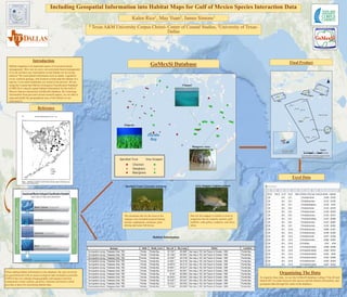
Including Geospatial Information into Habitat Maps for Gulf of Mexico Species Interaction Data
Habitat mapping is an important aspect of ecosystem-based
management. How can we carry out ecosystem-based management
if we do not have any information on the habitat we are trying
analyze? We need spatial information such as depth, vegetation
cover, surficial geology, and location to help map the habitat of a
species. Even small landmarks are useful in the process. We are
using the Coastal and Marine Ecological Classification Standard
(CMECS) to classify spatial habitat information for the Gulf of
Mexico Species Interaction (GoMexSI) database. By extracting
information from past and current research papers, we are able to
map and model the geographical area of the habitat we are
interested in.
Introduction
Reference
When adding habitat information to the database, the sites involved
are georeferenced with as much ecological data included as possible.
CMECS has two settings (biogeographic and aquatic) and four
components (water column, geoform, substrate and biotic) which
provides a basis for classifying habitat data.
Seagrass
Channel
Mangrove Area
Speckled Trout Cynoscion nebulosus
The dominant diet for the trout in the
seagrass area included penaeid shrimp,
mysids, amphipods, carideans, pink
shrimp and some fish larvae.
Habitat Information
Diet for the snapper is similar to trout in
seagrasses but ate isopods, grasses, gulf
toadfish, code gobies, seahorse, and silver
jenny.
Grey Snapper Lutjanus griseus
Final Product
Organizing The Data
To organize these data, we use the GoMexSI database coding (“Site ID and
Station ID”) to relate between fish species and the habitat information, and
geospatial data through the codes in the database.
Excel Data
GoMexSi Database