1. Bathymetry and Substrate Evaluation for an Oyster Bed Restoration Site
in Little Egg Harbor Bay, Ocean County NJ
Lauren O’Neil1, Evert, S2 and Straub, P2
Abstract
Stockton University is in the process of establishing a pilot-level oyster
restoration bed that will be used as a research site by the University. The survey
areas are part of the lower Barnegat Bay Watershed, and were mapped using
GIS software to assess the possibility of oyster restoration. Several specific areas
of interest were sampled within this survey site, in particular, Little Egg Harbor
Bay. Upon discovery of shelly bottom ground-truth data was collected, and a
potential favorable site was identified. Based on this finding, and consultation
from existing reports, a viable site in Little Egg Harbor Bay was recognized based
on promising sediment characteristics.
Background/Purpose
Stockton University investigated sediment composition of multiple parts of Little
Egg Harbor Bay as part of an effort to establish a restored oyster bed. These
potential oyster restoration sites will be used as an ongoing monitoring and
research site for Stockton University. This project will help both the environment
and society in many ways. Oysters act as natural filters by removing
phytoplankton and sediment from the water during feeding. This cleans the
water of excess particles, and keeps the environment healthy. Removal of
organic and inorganic particles results in clearer water, allowing species of
seagrass to grow easier. Oysters also provide habitat for fish, mollusks, barnacles,
mussels and other marine life, therefore enhancing potential oyster beds will
benefit other species. This keystone species will not only benefit the habitat, but
the economy as well. The oysters can be harvested for income, can supply
harvesters with jobs, and holds an educational value for Stockton University
students to maintain, replenish, and monitor the restoration site.
Methods
• Sidescan and multibeam sonar were used simultaneously to map areas of
interest aboard Stockton University’s RV Gannet in Little Egg Harbor Bay, NJ (Fig
1)
• Swath was adjusted based on depth to maximize survey potential.
• SeaBotix ROV was deployed at an area of interest for collection of ground-truth
data.
• A box sieve was used to obtain soil samples.
• EdgeTech software was used to post- process the lines of data, and make
necessary adjustments.
• Chesapeake’s Sonar Wiz was used to overlay lines of data, and crop unneeded
segments.
• Data was converted into tif, kmz, prj, and tfw files and exported to Google
Earth.
• A total of three potential sites were mapped.
Results
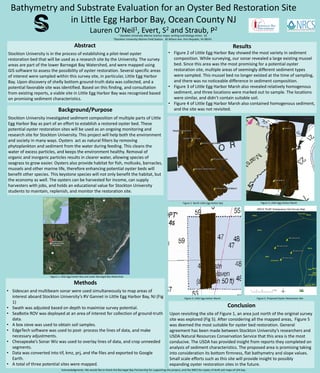
• Figure 2 of Little Egg Harbor Bay showed the most variety in sediment
composition. While surveying, our sonar revealed a large existing mussel
bed. Since this area was the most promising for a potential oyster
restoration site, multiple areas of seemingly different sediment types
were sampled. This mussel bed no longer existed at the time of sampling,
and there was no noticeable difference in sediment composition.
• Figure 3 of Little Egg Harbor Marsh also revealed relatively homogenous
sediment, and three locations were marked out to sample. The locations
were similar, and didn’t contain suitable soil.
• Figure 4 of Little Egg Harbor Marsh also contained homogenous sediment,
and the site was not revisited.
Conclusion
Upon revisiting the site of Figure 1, an area just north of the original survey
site was explored (Fig 5). After considering all the mapped areas, Figure 5
was deemed the most suitable for oyster bed restoration. General
agreement has been made between Stockton University’s researchers and
USDA Natural Resources Conservation Service that this area is the most
conducive. The USDA has provided insight from reports they completed on
analysis of sediment characteristics. The proposed area is promising taking
into consideration its bottom firmness, flat bathymetry and slope values.
Small scale efforts such as this site will provide insight to possibly
expanding oyster restoration sites in the future.
Figure 2. North Little Egg Harbor Bay Figure 3. Little Egg Harbor Marsh
Figure 4. Little Egg Harbor Marsh Figure 5. Proposed Oyster Restoration Site
Figure 1. Little Egg Harbor Bay and Lower Barnegat Bay Watershed
1 Stockton University Marine Science major, writing and biology minor, ‘16
2Stockton University Marine Field Station. 30 Wilson Ave. Port Republic, NJ 08241
Acknowledgments: We would like to thank the Barnegat Bay Partnership for supporting this project, and the NRCS for copies of draft soil maps of LEH bay