18.1 activity and rubrics
•Download as DOCX, PDF•
1 like•994 views

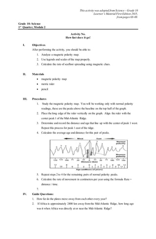
This activity analyzes a magnetic polarity map to calculate the rate of seafloor spreading. Students are instructed to measure the distance and date of normal polarity peaks on either side of the Mid-Atlantic Ridge and use the data to calculate the average rate of movement in centimeters per year. By determining the rate of seafloor spreading, students can then calculate how long ago Africa was located at the Mid-Atlantic Ridge based on its current distance. The objectives are to analyze magnetic maps, use legends and scales properly, and calculate rates of seafloor spreading using magnetic clues.

Recommended
More Related Content
Similar to 18.1 activity and rubrics
Similar to 18.1 activity and rubrics (9)
More from Heart Break Institution
More from Heart Break Institution (20)
Recently uploaded
Recently uploaded (20)
18.1 activity and rubrics
- 1. This activity was adopted from Science – Grade 10 Learner’s Material First Edition 2015, frompages 68-69. Grade 10- Science 1st Quarter, Module 2 Activity No. How fast does it go! I. Objectives After performing the activity, you should be able to: 1. Analyze a magnetic polarity map. 2. Use legends and scales of the map properly. 3. Calculate the rate of seafloor spreading using magnetic clues. II. Materials magnetic polarity map metric ruler pencil III. Procedures 1. Study the magnetic polarity map. You will be working only with normal polarity readings, these are the peaks above the baseline on the top half of the graph. 2. Place the long edge of the ruler vertically on the graph. Align the ruler with the center peak 1 of the Mid-Atlantic Ridge. 3. Determine and record the distance and age that line up with the center of peak 1 west. Repeat this process for peak 1 east of the ridge. 4. Calculate the average age and distance for this pair of peaks. 5. Repeat steps 2 to 4 for the remaining pairs of normal polarity peaks. 6. Calculate the rate of movement in centimeters per year using the formula Rate = distance / time. 7. IV. Guide Questions: 1. How far do the plates move away from each other every year? 2. If Africa is approximately 2400 km away from the Mid-Atlantic Ridge, how long ago was it when Africa was directly at or near the Mid-Atlantic Ridge?