More Related Content
Similar to Official_JaiSingh_APANO_ISS_Poster_FINAL
Similar to Official_JaiSingh_APANO_ISS_Poster_FINAL (20)
Official_JaiSingh_APANO_ISS_Poster_FINAL
- 1. Mapping for Climate Resiliency in the Jade District with the Asian Pacific American Network of Oregon (APANO):
Visualizing Methods to Increase Access to Affordable Housing, Parks, and Safe-Inclusive Transportation Infrastructure
Jai Singh (jai2@pdx.edu) – APANO/ISS Climate Resilience Intern – 2017 Candidate, Master of Urban and Regional Planning at Toulan School of Urban Studies & Planning, Portland State University
Sources: Esri, HERE, DeLorme, USGS, Intermap, increment P Corp.,
NRCAN, Esri Japan, METI, Esri China (Hong Kong), Esri (Thailand),
MapmyIndia, © OpenStreetMap contributors, and the GIS User
Community, Esri, HERE, DeLorme, MapmyIndia, © OpenStreetMap
contributors, and the GIS user community
I205
82ND
POWELL
DIVISION
I205FWY-POWELLBLVDI205
I205
I205
Esri, HERE, DeLorme, MapmyIndia, © OpenStreetMap contributors,
and the GIS user community
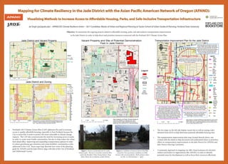
Jade District and Vacant Property
Jade District and Zoning
/
0 0.5 10.25 Miles
Legend
Jade
District
Boundary
Vacant
0 0.5 10.25 Miles
/
Maps created by Jai Singh (APANO/ISS Climate Resilience Intern)
on 4/26/16. Vacant property and zoning information obtained from
RLIS. Jade District boundary received by METRO.
Legend
Zoning Code
Jade
District
Boundary
Ma. Arteri.
Freeway
Streets
CG
CM
CN2
CO1
CO2
CS
EG2
EX
IG2
IR
OS
R1
R10
R2
R2.5
R3
R5
R7
RH
¾¾¿
¾¾¿
¾¾¿
¾¾¿
¾¾¿ ¾¾¿
¾¾¿ ¾¾¿
¾¾¿
¾¾¿
¾¾¿
¾¾¿
¾¾¿
¾¾¿
¾¾¿
¾¾¿ ¾¾¿
¾¾¿
¾¾¿
¾¾¿
¾¾¿
¾¾¿
¾¾¿
¾¾¿
¾¾¿
¾¾¿
¾¾¿
¾¾¿
¾¾¿
¾¾¿
¾¾¿¾¾¿¾¾¿¾¾¿
¾¾¿¾¾¿¾¾¿¾¾¿¾¾¿
¾¾¿¾¾¿¾¾¿
¾¾¿¾¾¿¾¾¿¾¾¿¾¾¿
¾¾¿¾¾¿¾¾¿¾¾¿¾¾¿¾¾¿¾¾¿¾¾¿
¾¾¿¾¾¿¾¾¿¾¾¿¾¾¿¾¾¿¾¾¿¾¾¿¾¾¿
82ndAvenueImplementationPlan-ODOT
Safe Routes To School
70sNeighborhoodGreenway-PBOT
Bus Rapid Tranist - TriMet, PBOT, Metro
72Bus
9 Bus
4 Bus SMALL STARTS transit project
I205
82ND
92ND
76TH
MILL
POWELL
DIVISION
96TH
75TH
79TH
78TH
77TH
CLINTON
87TH
89TH
TAYLOR
88TH
YAMHILL
86TH
84TH
MARKET
74TH
CLAY
RHINE
MADISON
90TH
TIBBETTS
80TH
85TH
81ST
STEPHENS
I205FWY-POWELLBLVD
WOODWARD
BROOKLYN
KELLY
MAIN
POWELLBLVD-DIVISIONST
94TH
83RD
LINCOLN
HARRISON
TAGGART
SALMON
MAINPARKANDRIDE
HAWTHORNE
FRANKLIN
HARRISON
84TH
77TH
75TH
87TH
76TH
80TH
81ST
CLINTON
76TH
TAYLOR
85TH
TAYLOR
77TH
94TH
74TH
79TH
84TH
86TH
I205
76TH
75TH
MILL
76TH
88TH
84TH
90TH
89TH
TAYLOR
YAMHILL
MARKET
STEPHENS
78TH
MAIN
Sources: Esri, HERE, DeLorme, USGS, Intermap, increment P
Corp., NRCAN, Esri Japan, METI, Esri China (Hong Kong), Esri
(Thailand), MapmyIndia, © OpenStreetMap contributors, and the
GIS User Community
F
0 0.25 0.50.125 Miles
Map created by Jai Singh (APANO/ISS Climate Resilience Intern) & PSU
MURP student on 4/10/16. Source obtained from RLIS. Referenced an
ODOT vicinity map for neighborhood greenway and hand drawn map by
Duncan Hwang. Basemap from ESRI.
Transportation Improvement Plan for the Jade District
The Powell-Division Transit and Development
project is a partnership among the cities of Portland
and Gresham, Multnomah County, the Oregon
Department of Transportation, Trimet and Metro.
The Bus Rapid Transit (BRT) project currently being
planned is designed to create a better experience and
faster ride for the people who board buses on Powell
Boulevard and Division Street. The partnership is counting
on dollar-for-dollar matching grants from the federal
'Small Starts' program. This project is also apart of the
Service Enhancement Plan (SEP) at TriMet.
The City of Portland is updating the Transportation
Systems Plan (TSP), the long range plan guiding
transportation investments in the City. Periodic updates
of the TSP are mandated by the State of Oregon.
Addressing safety for all people who use 82nd
Avenue whether walking, biking, taking transit
or driving. ODOT owns, operates, and maintains
82nd Avenue between the curbs. The City or
adjacent land owners own and maintain sidewalk
between the curbs and buildings/parking lots.
The City of Portland, with input from ODOT,
programs the traffic signals on 82nd Ave.
Project will create a high
quality, safe, and
comfortable north-south
walking and bicycling route
running parallel to 82nd
Ave through multiple
neighborhoods of NE and
SE Portland. The project
will include traffic calming
and way-finding elements
on local streets.Project is
comprised of three phases.
A partnership between the City of Portland, schools,
neighborhoods, community organizations and agencies,
to increase safety for students and families to bike, walk,
and to reduce congestion.
Orphan Highway Bills - aim to improve state highways
that have lost traffic volume to more popular
Interstate Highways. 82nd Ave. is expected to be
highly eligible on that list for funding.
Legend
ODOT
PBOT
Jade
District
BES
(BRT)
Tri Met,
PBOT,
METRO
PBOT
(TSP)
Schools
Streets
JAMS
(Metro,
PHB,
Sara
Archit.
& Rose)
APANO/
Jade
Office
Columbia
Land Trust,
METRO,
Parks &
Rec
PBOT
(& other
organi-
zations)
Nursery
72 Bus
9 Bus
4 Bus
¾¾¿
5
¾¾¿
¾¾¿
¾¾¿
• Portland’s 2015 Climate Action Plan (CAP) addresses the need to increase
access to quality affordable housing, especially in East Portland, because the
City is aware that it needs to protect the most vulnerable to climate change
impacts. The CAP also communicates the need for increasing access to parks
in order to create more livable communities, but also to help reduce the urban
heat island effect. Improving and expanding transportation options in order
to reduce greenhouse gas emissions and create healthier communities is also
addressed in the CAP. These maps help illustrate how some of the planning
goals for APANO and the Jade District align with that of the City of Portland
and Multnomah County.
• The two maps on the left side display vacant lots as well as zoning codes
obtained from RLIS to help determine potential affordable housing sites.
• The transportation improvement plan map, located directly above, was
created with the intent to help document and understand where to prioritize
efforts to transportation improvements in the Jade District for APANO and
Jade District Steering Committee.
• A systematic approach to mapping can offer visual assistance for decision
makers and leaders in organizations like APANO, in order to identify
potential areas for development as well as focus their resources effectively.
Figure 1. Picture of potential site for a Jade
District park. The site is currently owned by BES,
and is the Brooklyn Water Pump Station. Map
above shows site in relation to Jade District.
Figure 2. Condition of street in front of the BES
owned lot. Poor pavement conditions on 89th
Avenue with several potholes. (Both pictures taken
on Feb. 12, 2016 between 1 - 2pm).
I205
92ND
DIVISION
87TH
89TH
CLINTON
84TH
96TH
BUSH
91ST
RHINE
90TH
80TH
85TH
81ST
STEPHENS
I205FWY-POWELLBLVD
86TH
BROOKLYN
RHONE
LAFAYETTE
KELLY
97TH
88TH
DIVISIONST-POWELLBLVD
CORA
FRANCIS
TIBBETTS
BOISE
LINCOLN
HARRISON
94TH
TAGGART
83RD
POWELLBLVD-I205FWY
WOODWARD
DIVISIONST-I205FWY
CENTER
93RD
I205FWY-DIVISIONST
FRANKLIN
GLADSTONE
GRANT
POWELLBLVDPARKANDRIDE
CARUTHERS
POWELLGARAGETC
VICTOR
LAFAYETTE
90TH
CLINTON
80TH
94TH
84TH
I205
LINCOLN
94TH
84TH
HARRISON
GLADSTONE
HARRISON
DIVISIONST-I205FWY
87TH
80TH
TAGGART
83RD
85TH
BUSH
83RD
80TH
81ST
LINCOLN
89TH
94TH
90TH
RHONE
85TH
BOISE
84TH
I205
92ND
82ND
POWELL
DIVISION
POWELLBLVD-I205FWYI205
© OpenStreetMap (and) contributors, CC-BY-SA
89TH
90TH
BROOKLYN
© OpenStreetMap (and)
contributors, CC-BY-SA
F
Vacant Property and Site of Potential Demonstration
Park in Jade District
Map created by Jai Singh (Climate Resilience
Intern for APANO) on February 26, 2016.
Vacant property data obtained from RLIS.
Basemap was obtianed from OpenStreetMap.
0 0.25 0.50.125 Miles
Jade
District
Boundary
Legend
Potential
Demonstration
Park
Vacant
Objective: To summarize the ongoing projects related to affordable housing, parks, and safe inclusive transportation improvements
in the Jade District in order to help direct and prioritize resources connected with the Portland 2015 Climate Action Plan.