The geothermal reservoir and the development of a new production feld in Hellisheiði
•
1 like•79 views

Gunnar Gunnarsson, Reykjavik Energy, OR Iceland Geothermal Conference 2013 March 5-8, 2013, Harpa, Reykjavík
![Introduction
390
392
394
396
398
400
402
404
ISNETY[km]
380 382 384 386 388 390 392
ISNET X [km]
390
392
394
396
398
400
402
404
ISNETY[km]
380 382 384 386 388 390 392
ISNET X [km]
0
200
400
600
800
m y.s.
Bitra
Hverahlíð
Hellisheiði
Nesjavellir
Hengill
Reykjavík
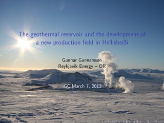
The Hengill is a central
volcano.
Two production elds are in
the area: Nesjavellir
(120 MWe) and Hellisheiði
(303 MWe).
Nesjavellir Power Plant
commissioned in 1990. First
wells drilled in 1972 last
unit commissioned in 2005.
In Hellisheiði drilling started
in 2002, rst units were
commissioned 2006 and the
last in 2011.](data:image/gif;base64,R0lGODlhAQABAIAAAAAAAP///yH5BAEAAAAALAAAAAABAAEAAAIBRAA7)
Recommended
Recommended
More Related Content
Similar to The geothermal reservoir and the development of a new production feld in Hellisheiði
Similar to The geothermal reservoir and the development of a new production feld in Hellisheiði (20)
More from Iceland Geothermal
More from Iceland Geothermal (20)
Recently uploaded
Recently uploaded (20)
The geothermal reservoir and the development of a new production feld in Hellisheiði
- 1. The geothermal reservoir and the development of a new production eld in Hellisheiði Gunnar Gunnarsson Reykjavik Energy OR IGC March 7, 2013
- 2. Introduction 390 392 394 396 398 400 402 404 ISNETY[km] 380 382 384 386 388 390 392 ISNET X [km] 390 392 394 396 398 400 402 404 ISNETY[km] 380 382 384 386 388 390 392 ISNET X [km] 0 200 400 600 800 m y.s. Bitra Hverahlíð Hellisheiði Nesjavellir Hengill Reykjavík The Hengill is a central volcano. Two production elds are in the area: Nesjavellir (120 MWe) and Hellisheiði (303 MWe). Nesjavellir Power Plant commissioned in 1990. First wells drilled in 1972 last unit commissioned in 2005. In Hellisheiði drilling started in 2002, rst units were commissioned 2006 and the last in 2011.
- 3. The Hengill Area Surface exploration 390 392 394 396 398 400 402 404 ISNETY[km] 380 382 384 386 388 390 392 ISNET X [km] 390 392 394 396 398 400 402 404 ISNETY[km] 380 382 384 386 388 390 392 ISNET X [km] 0 200 400 600 800 m y.s. Bitra Hverahlíð Hellisheiði Nesjavellir Hengill Reykjavík The Hengill Area is a central volcano Volcanic craters, hot springs and fumaroles.
- 4. The Hengill Area Surface exploration 390 392 394 396 398 400 402 404 ISNETY[km] 380 382 384 386 388 390 392 ISNET X [km] 390 392 394 396 398 400 402 404 ISNETY[km] 380 382 384 386 388 390 392 ISNET X [km] 0 200 400 600 800 m y.s. Bitra Hverahlíð Hellisheiði Nesjavellir Hengill Reykjavík The Hengill Area is a central volcano Volcanic craters, hot springs and fumaroles. Highest degree of alteration in the highest part of the Hengill Mountains.
- 5. The Hengill Area Surface exploration 390 392 394 396 398 400 402 404 ISNETY[km] 380 382 384 386 388 390 392 ISNET X [km] 390 392 394 396 398 400 402 404 ISNETY[km] 380 382 384 386 388 390 392 ISNET X [km] 0 200 400 600 800 m y.s. Bitra Hverahlíð Hellisheiði Nesjavellir Hengill Reykjavík The Hengill Area is a central volcano Volcanic craters, hot springs and fumaroles. Highest degree of alteration in the highest part of the Hengill Mountains. Resistivity measurements (TEM) show large area where high resistivity core is under low resistivity cap.
- 6. The Hengill Area Surface exploration 390 392 394 396 398 400 402 404 ISNETY[km] 380 382 384 386 388 390 392 ISNET X [km] 390 392 394 396 398 400 402 404 ISNETY[km] 380 382 384 386 388 390 392 ISNET X [km] 0 200 400 600 800 m y.s. Bitra Hverahlíð Hellisheiði Nesjavellir Hengill Reykjavík The Hengill Area is a central volcano Volcanic craters, hot springs and fumaroles. Highest degree of alteration in the highest part of the Hengill Mountains. Resistivity measurements (TEM) show large area where high resistivity core is under low resistivity cap. Power estimates based on resistivity survey.
- 7. Conceptual model of a Volcanic geothermal system
- 8. Old Conceptual model of the Hengill Area
- 9. The rst wells in Hellisheiði 390 392 394 396 398 400 402 404 ISNETY[km] 380 382 384 386 388 390 392 ISNET X [km] 390 392 394 396 398 400 402 404 ISNETY[km] 380 382 384 386 388 390 392 ISNET X [km] 0 200 400 600 800 m y.s. Bitra Hverahlíð Hellisheiði Nesjavellir Hengill Reykjavík He-04 He-07 He-03 He-06 0 500 1000 1500 2000 0 100 200 300 d[m] HE−03 T [°C] 0 500 1000 1500 2000 0 100 200 300 d[m] HE−04 T [°C] 0 500 1000 1500 2000 0 100 200 300 d[m] HE−06 T [°C] 0 500 1000 1500 2000 2500 0 100 200 300 d[m] HE−07 T [°C]
- 10. Formation temperature Hengill 388 390 392 394 396 398 400 402 404 406 ISNETY[km] 380 382 384 386 388 390 392 ISNET X [km] 120 120 160 160 160 200 200 200 200 240 240 240 240 388 390 392 394 396 398 400 402 404 406 ISNETY[km] 380 382 384 386 388 390 392 ISNET X [km] 100 150 200 250 300 T [°C] Form. temp. 500 m b.s.l. Well data formation temperature. The formation temperature unveils the thermodynamics of the geothermal system. The formation temperature in the Hengill Area is characterize by sharp structures. Hotter areas separated by cooler ones separate heat sources... ...or sharp changes in permeability.
- 11. Formation temperature Hengill 388 390 392 394 396 398 400 402 404 406 ISNETY[km] 380 382 384 386 388 390 392 ISNET X [km] 200 200 200 240 240 240240 240 240 280 280 280 388 390 392 394 396 398 400 402 404 406 ISNETY[km] 380 382 384 386 388 390 392 ISNET X [km] 100 150 200 250 300 T [°C] Form. temp. 1000 m b.s.l. 388 390 392 394 396 398 400 402 404 406 ISNETY[km] 380 382 384 386 388 390 392 ISNET X [km] 240 240 240 240 240 280 280 280 280 388 390 392 394 396 398 400 402 404 406 ISNETY[km] 380 382 384 386 388 390 392 ISNET X [km] 100 150 200 250 300 T [°C] Form. temp. 1500 m b.s.l.
- 12. Formation temperature in Hellisheiði 389 390 391 392 393 394 395 396 397 398 399 400 401 ISNETY[km] 380 381 382 383 384 385 386 387 ISNET X [km] 120 160 160 200 200 200 240 240 240 389 390 391 392 393 394 395 396 397 398 399 400 401 ISNETY[km] 380 381 382 383 384 385 386 387 ISNET X [km] 100 150 200 250 300 T [°C] Form. temp. 500 m b.s.l. 389 390 391 392 393 394 395 396 397 398 399 400 401 ISNETY[km] 380 381 382 383 384 385 386 387 ISNET X [km] 200 240 240 240 280 280 280 280 389 390 391 392 393 394 395 396 397 398 399 400 401 ISNETY[km] 380 381 382 383 384 385 386 387 ISNET X [km] 100 150 200 250 300 T [°C] Form. temp. 1500 m b.s.l.
- 13. Formation temperature in Hellisheiði 389 390 391 392 393 394 395 396 397 398 399 400 401 ISNETY[km] 380 381 382 383 384 385 386 387 ISNET X [km] 200 200 240 240 240 240 240 280 280 280 280 HE−03 HE−04 HE−06 HE−07 HE−57 HE−36 389 390 391 392 393 394 395 396 397 398 399 400 401 ISNETY[km] 380 381 382 383 384 385 386 387 ISNET X [km] 100 150 200 250 300 T [°C] Form. temp. 1000 m b.s.l. 0 500 1000 1500 2000 0 100 200 300 d[m] HE−03 T [°C] 0 500 1000 1500 2000 0 100 200 300 d[m] HE−04 T [°C] 0 500 1000 1500 2000 0 100 200 300 d[m] HE−06 T [°C] 0 500 1000 1500 2000 2500 0 100 200 300 d[m] HE−07 T [°C] 0 500 1000 1500 2000 2500 0 100 200 300 d[m] HE−36 T [°C] 0 500 1000 1500 2000 2500 3000 0 100 200 300 d[m] HE−57 T [°C]
- 14. Formation temperature in Hellisheiði 389 390 391 392 393 394 395 396 397 398 399 400 401 ISNETY[km] 380 381 382 383 384 385 386 387 ISNET X [km] 200 200 240 240 240 240 240 280 280 280 280 HE−26 Reykjafell HE−10 HE−36 HN−01 HE−21 Gráuhnúkar A A’ B B’ 389 390 391 392 393 394 395 396 397 398 399 400 401 ISNETY[km] 380 381 382 383 384 385 386 387 ISNET X [km] 100 150 200 250 300 T [°C] Berghiti 1000 m u.s. 0 20 406080100120140160 180 200 220 220 240 240 260 260 280 280 300 −3000 −2000 −1000 0 1000 Elevationa.s.l.[m] −2000 −1000 0 1000 2000 Position [m] 50 100 150 200 250 300 T °C HE−10 HE−26 Reykjafell A A’ −20 0 20 406080100120140 160 180 200 200 220 220 240 240 260 260 280 280 280 300 300 320 −3000 −2000 −1000 0 1000 Elevationa.s.l.[m] −3000 −2000 −1000 0 1000 2000 3000 Position [m] 50 100 150 200 250 300 T °C HE−21 HE−36 HN−01 Gráuhnúkar B B’
- 15. Formation temperature in the Hengill Area Localized maxima in formation temperature cooler regions in between. Sharp structures. Reversed temperature gradient on the edge of the hottest regions. Separate heat sources drive the geothermal activity. Older conceptual models that postulate a single heat source under the highest part of the Hengill Mountains that drives the geothermal elds in the Hengill Area are in contradiction with observed distribution of formation temperature. New conceptual model assume that the geothermal elds in the area are driven by individual heat sources1. 1 Here a heat sources means the hot body that interacts to the water circulation
- 16. The development of a eld and conceptual models Conceptual models do evolve during the development of a geothermal eld when new information become available. This is why it has been postulated that geothermal operation should be developed in steps. All decisions on the size of the Hellisheiði Power Plant were made before the data from the drilling operation became available. These decisions were based on limited information on the initial state of the reservoir and no production history data. Production in the Hellisheiði Field is concentrated on the hottest part of the system.
- 17. Distribution of production 392 393 394 395 396 397 398 399 400 ISNETN[km] 382 383 384 385 386 387 388 ISNET A [km] 100 100 200 200 300 300 392 393 394 395 396 397 398 399 400 ISNETN[km] 382 383 384 385 386 387 388 ISNET A [km] 392 393 394 395 396 397 398 399 400 ISNETN[km] 382 383 384 385 386 387 388 ISNET A [km] Distribution of the total mass production 0 50 100 150 200 250 300 kg/s/km2 392 393 394 395 396 397 398 399 400 ISNETN[km] 382 383 384 385 386 387 388 ISNET A [km] 50 50 100 150 150 392 393 394 395 396 397 398 399 400 ISNETN[km] 382 383 384 385 386 387 388 ISNET A [km] 392 393 394 395 396 397 398 399 400 ISNETN[km] 382 383 384 385 386 387 388 ISNET A [km] Distribution of the steam production 0 50 100 150 200 250 300 kg/s/km2
- 18. Distribution of production playing with numbers The mass production pro km2 is 300 kg/s/km2 in the center of the production eld. If no recharge drawdown in the time interval ∆T is given by: ∆d = Q A 1 ρφ ∆T If porosity is 10% and temperature 275◦C (ρ = 759 kg/m3) drawdown in a year is: ∆d = 3 × 10⁻⁴ kg/m2/s 759 kg/m3 · 0.1 3.16 × 10⁷ s ∆d = 125 m
- 19. Pressure drawdown Mass in and out Drawdown is dependent on two more important parameters. Natural recharge (Qnr ) and Reinjection (Qri ). Drawdown taking those parameters into account is given by: ∆d = Qp − Qnr − Qri Aρφ ∆T. Drawdown can be decreased by reinjecting and spreading the production.
- 20. Managing the reservoir reinjection 390 392 394 396 398 400 ISNETY[km] 376 378 380 382 384 386 388 ISNET X [km] 390 392 394 396 398 400 ISNETY[km] 376 378 380 382 384 386 388 ISNET X [km] 390 392 394 396 398 400 ISNETY[km] 376 378 380 382 384 386 388 ISNET X [km] 390 392 394 396 398 400 ISNETY[km] 376 378 380 382 384 386 388 ISNET X [km] 390 392 394 396 398 400 ISNETY[km] 376 378 380 382 384 386 388 ISNET X [km] 390 392 394 396 398 400 ISNETY[km] 376 378 380 382 384 386 388 ISNET X [km] 390 392 394 396 398 400 ISNETY[km] 376 378 380 382 384 386 388 ISNET X [km] 390 392 394 396 398 400 ISNETY[km] 376 378 380 382 384 386 388 ISNET X [km] 390 392 394 396 398 400 ISNETY[km] 376 378 380 382 384 386 388 ISNET X [km] 390 392 394 396 398 400 ISNETY[km] 376 378 380 382 384 386 388 ISNET X [km] 390 392 394 396 398 400 ISNETY[km] 376 378 380 382 384 386 388 ISNET X [km] 390 392 394 396 398 400 ISNETY[km] 376 378 380 382 384 386 388 ISNET X [km] 390 392 394 396 398 400 ISNETY[km] 376 378 380 382 384 386 388 ISNET X [km] 390 392 394 396 398 400 ISNETY[km] 376 378 380 382 384 386 388 ISNET X [km] 390 392 394 396 398 400 ISNETY[km] 376 378 380 382 384 386 388 ISNET X [km] 390 392 394 396 398 400 ISNETY[km] 376 378 380 382 384 386 388 ISNET X [km] 390 392 394 396 398 400 ISNETY[km] 376 378 380 382 384 386 388 ISNET X [km] 390 392 394 396 398 400 ISNETY[km] 376 378 380 382 384 386 388 ISNET X [km] 390 392 394 396 398 400 ISNETY[km] 376 378 380 382 384 386 388 ISNET X [km] 390 392 394 396 398 400 ISNETY[km] 376 378 380 382 384 386 388 ISNET X [km] 390 392 394 396 398 400 ISNETY[km] 376 378 380 382 384 386 388 ISNET X [km] 390 392 394 396 398 400 ISNETY[km] 376 378 380 382 384 386 388 ISNET X [km] 390 392 394 396 398 400 ISNETY[km] 376 378 380 382 384 386 388 ISNET X [km] 390 392 394 396 398 400 ISNETY[km] 376 378 380 382 384 386 388 ISNET X [km] 390 392 394 396 398 400 ISNETY[km] 376 378 380 382 384 386 388 ISNET X [km] 390 392 394 396 398 400 ISNETY[km] 376 378 380 382 384 386 388 ISNET X [km] 390 392 394 396 398 400 ISNETY[km] 376 378 380 382 384 386 388 ISNET X [km] 390 392 394 396 398 400 ISNETY[km] 376 378 380 382 384 386 388 ISNET X [km] 390 392 394 396 398 400 ISNETY[km] 376 378 380 382 384 386 388 ISNET X [km] 390 392 394 396 398 400 ISNETY[km] 376 378 380 382 384 386 388 ISNET X [km] 390 392 394 396 398 400 ISNETY[km] 376 378 380 382 384 386 388 ISNET X [km] 390 392 394 396 398 400 ISNETY[km] 376 378 380 382 384 386 388 ISNET X [km] 390 392 394 396 398 400 ISNETY[km] 376 378 380 382 384 386 388 ISNET X [km] 390 392 394 396 398 400 ISNETY[km] 376 378 380 382 384 386 388 ISNET X [km] 390 392 394 396 398 400 ISNETY[km] 376 378 380 382 384 386 388 ISNET X [km] 390 392 394 396 398 400 ISNETY[km] 376 378 380 382 384 386 388 ISNET X [km] 390 392 394 396 398 400 ISNETY[km] 376 378 380 382 384 386 388 ISNET X [km] 390 392 394 396 398 400 ISNETY[km] 376 378 380 382 384 386 388 ISNET X [km] 390 392 394 396 398 400 ISNETY[km] 376 378 380 382 384 386 388 ISNET X [km] 390 392 394 396 398 400 ISNETY[km] 376 378 380 382 384 386 388 ISNET X [km] 390 392 394 396 398 400 ISNETY[km] 376 378 380 382 384 386 388 ISNET X [km] 390 392 394 396 398 400 ISNETY[km] 376 378 380 382 384 386 388 ISNET X [km] 390 392 394 396 398 400 ISNETY[km] 376 378 380 382 384 386 388 ISNET X [km] 390 392 394 396 398 400 ISNETY[km] 376 378 380 382 384 386 388 ISNET X [km] 390 392 394 396 398 400 ISNETY[km] 376 378 380 382 384 386 388 ISNET X [km] 390 392 394 396 398 400 ISNETY[km] 376 378 380 382 384 386 388 ISNET X [km] 390 392 394 396 398 400 ISNETY[km] 376 378 380 382 384 386 388 ISNET X [km] H e l l i s h e i ð i H úsm úli G ráuhnúkar Reykjavík 20 km Reinjection zones of the Hellisheiði Power Plant. The Gráuhnúkar Reinjection Zone commissioned in 2007 High formation temperature ( 300◦C). The Húsmúli Reinjection Zone commissioned in 2011. The Gráuhnúkar Zone viewed as a possible zone for make-up wells.
- 21. Pressure Drawdown in Hellisheiði −40 −35 −30 −25 −20 −15 −10 −5 0 2000 2005 2010 2015 2020 2025 2030 2035 2040 Drawdown∆P[bar] year Pressure drawdown in well HE−04 Measured Model Reference
- 22. Future management of the Hellisheiði Field 390 391 392 393 394 395 396 397 398 399 ISNETY[km] 380 381 382 383 384 385 386 387 ISNET X [km] 200 200 240 240 240 240 280 280 280 280 390 391 392 393 394 395 396 397 398 399 ISNETY[km] 380 381 382 383 384 385 386 387 ISNET X [km] 100 150 200 250 300 T [°C] Hverahlíð H ellisheiði Gráuhnúkar Húsmúli Form. temp. 1000 m b.s.l. The Hellisheiði Field is narrow and needs to be enlarged. The Gráuhnúkar Zone viewed as a possible zone for make-up wells. Injection supports the pressure in the center of the system. Disposal of geothermal water needs to be addressed. The Hverahlíð Field a new production zone or make-up zone for Hellisheiði?
- 23. Summary and conclusion Surface exploration gives a limited information on the size and state of the of the geothermal reservoir. Direct measurements on the size of the reservoir rst become available with exploratory drilling. The development of the production eld in Hellisheiði was undertaken in a very fast pace Decisions were often based on limited information. The production in the Hellisheiði Field is concentrated in a narrow strip, where the density of production is very high. Managing the production in the Hellisheiði Field will be a challenge due to the high production rate per area. It is desirable to enlarge the production area: Possible make-up zones Gráuhnúkar and Hverahlíð.
- 24. Thank you for your attention.