Aviation Meteorology

The purpose of this paper is to highlight the general terms and definitions that falls under the ‘common set’ in the intersection of the sets Meteorology and Aerospace Engineering. It begins with the universal explanations for the meteorological phenomena under the ‘common set’ followed by the categorization of clouds and their influences on the aerial vehicles, the instrumentation used in Aeronautics to determine the required Meteorological quantities, factors affecting aviation, effects of aviation on the clouds, and the corresponding protocols involved in deciphering the ‘common set’ elements. It also talks about the relation between airport construction and Geology prior to concluding with the uses and successes of Meteorology in the field of Aerospace.

Recommended
Recommended
More Related Content
What's hot
What's hot (20)
Similar to Aviation Meteorology
Similar to Aviation Meteorology (20)
More from IJLT EMAS
More from IJLT EMAS (20)
Recently uploaded
Recently uploaded (20)
Aviation Meteorology
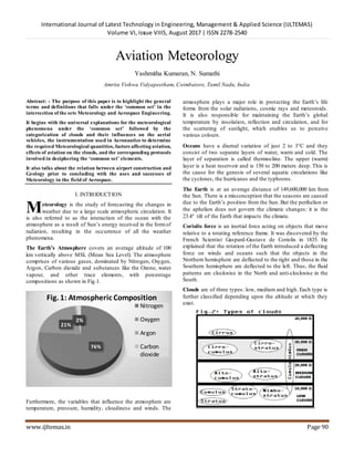
- 1. International Journal of Latest Technology in Engineering, Management & Applied Science (IJLTEMAS) Volume VI, Issue VIIIS, August 2017 | ISSN 2278-2540 www.ijltemas.in Page 90 Aviation Meteorology Yashmitha Kumaran, N. Sumathi Amrita Vishwa Vidyapeetham, Coimbatore, Tamil Nadu, India Abstract: - The purpose of this paper is to highlight the general terms and definitions that falls under the ‘common set’ in the intersection of the sets Meteorology and Aerospace Engineering. It begins with the universal explanations for the meteorological phenomena under the ‘common set’ followed by the categorization of clouds and their influences on the aerial vehicles, the instrumentation used in Aeronautics to determine the required Meteorological quantities, factors affecting aviation, effects of aviation on the clouds, and the corresponding protocols involved in deciphering the ‘common set’ elements. It also talks about the relation between airport construction and Geology prior to concluding with the uses and successes of Meteorology in the field of Aerospace. I. INTRODUCTION eteorology is the study of forecasting the changes in weather due to a large scale atmospheric circulation. It is also referred to as the interaction of the ocean with the atmosphere as a result of Sun‟s energy received in the formof radiation, resulting in the occurrence of all the weather phenomena. The Earth’s Atmosphere covers an average altitude of 100 km vertically above MSL (Mean Sea Level). The atmosphere comprises of various gases, dominated by Nitrogen, Oxygen, Argon, Carbon dioxide and substances like the Ozone, water vapour, and other trace elements, with percentage compositions as shown in Fig.1. Furthermore, the variables that influence the atmosphere are temperature, pressure, humidity, cloudiness and winds. The atmosphere plays a major role in protecting the Earth‟s life forms from the solar radiations, cosmic rays and meteoroids. It is also responsible for maintaining the Earth‟s global temperature by insolation, reflection and circulation, and for the scattering of sunlight, which enables us to perceive various colours. Oceans have a diurnal variation of just 2 to 3C and they consist of two separate layers of water, warm and cold. The layer of separation is called thermocline. The upper (warm) layer is a heat reservoir and is 150 to 200 meters deep. This is the cause for the genesis of several aquatic circulations like the cyclones, the hurricanes and the typhoons. The Earth is at an average distance of 149,600,000 km from the Sun. There is a misconception that the seasons are caused due to the Earth‟s position from the Sun. But the perihelion or the aphelion does not govern the climatic changes: it is the 23.4 tilt of the Earth that impacts the climate. Coriolis force is an inertial force acting on objects that move relative to a rotating reference frame. It was discovered by the French Scientist Gaspard-Gustave de Coriolis in 1835. He explained that the rotation of the Earth introduced a deflecting force on winds and oceans such that the objects in the Northern hemisphere are deflected to the right and those in the Southern hemisphere are deflected to the left. Thus, the fluid patterns are clockwise in the North and anti-clockwise in the South. Clouds are of three types: low, medium and high. Each type is further classified depending upon the altitude at which they exist. 76% 21% 1%0%2% Fig. 1: Atmospheric Composition Nitrogen Oxygen Argon Carbon dioxide M
- 2. International Journal of Latest Technology in Engineering, Management & Applied Science (IJLTEMAS) Volume VI, Issue VIIIS, August 2017 | ISSN 2278-2540 www.ijltemas.in Page 91 Fig. 2 summarises these classing: Cirrus clouds are thin and wispy, and are composed of ice- crystals. Cirrostratus clouds are translucent and white, and are capable of forming Halos and Corona around the Sun or the Moon during cyclones. Cirrocumulus clouds contain tiny ice crystals and form a variety of shapes in the sky. They never precipitate. Altostratus clouds that cover the whole sky, are made up of water droplets mostly and can cause continuous rains. Altocumulus clouds merely comprise of water droplets, look like cotton rolls and can indicate the onset of a storm. Nimbostratus clouds are thick swirls of dark clouds that precede a thunder cloud, with heavy showers – common in subtropical areas. Cumulonimbus clouds, or thunderclouds, are the common, but dangerous formof giant clouds. Stratocumulus, Cumulus, and Stratus clouds can give a mild rain, shower and drizzle respectively. II. THUNDERCLOUDS AND ITS HAZARDS IN AVIATION Due to the conventional movement of hot air rising and cool air sinking, the vertical growth of (Cumulus) clouds from 10,000 ft. to 40,000 ft. leads to the formation of the Cumulonimbus clouds. These thunderclouds keep growing until they hit the tropopause. The top of such clouds spread around and develop into an anvil shape.The updraft of the hot air currents at ~35 km/h cause friction between the air and the water drops. This results in the accumulation of negative charges in the cloud‟s base and an equal amount of positive charges at higher levels with temperatures around –20C. Hail and snow occurs if the water droplets at that altitude reach the triple point, while the thundercloud dissipates after a downdraft at ~85 km/h and a shower. Statistics reveal that ~40% of air accidents are due to adverse weather and ~8% of them are due to thunderstorms. The following are the most common causes: Accretion of ice during a hailstorm can affect the wing aerodynamics of a plane. Big hail stones can cause severe physical damage to the airplane body. Since an aircraft is covered by an insulator, a lightning does not affect it, by going around it‟s body; this is known as Faraday’s Cage Effect. Although, in rare cases, the flight engines have caught fire during a thunderstormvia the aviation fuel. Thunderclouds induce zones of turbulence due to erratic updrafts and downdrafts. Acute summer can create low density air pockets, causing Clear Air Turbulence, which is an unpredictable aviation hazard not connected with thunderstorm. When the downdraft begins, the surface wind exceeds 90 km/h and lasts for a few minutes; this is called as squall. Squall can delay take-offs and landings, and can potentially damage smaller aircrafts on the ground that are improperly moored. Lightning produces a spectrum of electromagnetic waves that could block radio waves from an aircraft and disrupt communication; this is known as spherics. III. METEOROLOGICAL INSTRUMENTATION Aviation extensively relies on the following instruments: i. Thermometer – to measure the temperature Mercury thermometer measures the maximum temperature of the day Alcohol thermometer measures the minimum temperature of the day ii. Barometer – to measure the atmospheric pressure Altimeter – to measure aircraft altitude using increasing or decreasing pressure iii. Anemometer – to measure the wind speed iv. Hygrometer – to measure the humidity of the surrounding air Psychrometer – to measure the relative humidity of air v. Wind Vane – to indicate the direction of the wind vi. Rain / Snow Gauge – to measure the amount of rainfall / snowfall Intensity rain gauge determines the rate at which rain occurs at a particular period vii. Lidar – measures the distance and other parameters of a distant cloud using a laser viii. Ceiling Projector – to measure the altitude of the clouds at night ix. Transmissometer – to measure the visibility range x. Weather Satellites – to measure and track large - scale air movements. Additionally, the following abet the aviation industry, as well, for safety precautions: Weather Balloon measures temperature, pressure, wind speed and wind direction simultaneously, at high altitudes Synoptic chart sums up the movement of pressure, temperature and wind patterns Wind rose diagam maps the wind speed and direction at a location, graphically METAR reports details such as current weather, cloud quantity, types and levels, visibility, etc. with a Trend Forecast, that specifies if the weather
- 3. International Journal of Latest Technology in Engineering, Management & Applied Science (IJLTEMAS) Volume VI, Issue VIIIS, August 2017 | ISSN 2278-2540 www.ijltemas.in Page 92 conditions were improving or deteriorating, for every thirty minutes to two hours. IV. VISIBILITY VERSUS AVIATION Visibility is usually defined as the distance at which an object can be seen clearly. When this reduces, it can be categorized into: Haze, when the visibility is more than just a kilometre Thick mist, when the visibility is around one kilometre Fog, when the visibility is less than one kilometre. Fog is a suspension of tiny water droplets in air. It forms if the surface wind is calm, inversion (the phenomena of air becoming colder near the surface during winter) of temperature occurs, and the surrounding air becomes saturated (holds maximum water vapor at that temperature). When moist air from the sea moves into a colder land and cools down, it forms advection fog. Smoke with fog is called smog. Sometimes, thick fog reduces the visibility to less than half a kilometre. In that case, the meteorological services involved in aviation declare the visibility as NIL, and the aircraft is diverted to a nearby airport. Advection fog dominates in coastal areas, leading to mass delays and cancellations. It can even block airports that are very close to the sea or are situated below MSL. While smog is predominant in almost all the busy countries during winter, it can affect RVR (Runway Visibility Range: horizontal visibility along the runway) requiring the airports to employ LVP (Low Visibility Procedures), especially if RVR is less than 400 metres. On the other hand, aeronautics is used to disperse warm fog or the fog emerging at temperatures above -4C: Helicopters send dry air currents to mix with the fog below; it clears small areas Jet engines hurl heat over the runway approach zone, thus, blowing away the fog. V. CONTINUOUS GUSTS Winds that vary haphazardly are called continuous gusts or stochastic gusts. Continuous gust models can represent the turbulence in the atmosphere. It is particularly useful in distinguishing Clear Air Turbulence in Summer and turbulent winds in storms. They develop from the turbulence due to frictional force, the shear force in the winds or the solar heating of the ground. They can destabilize aircrafts in a very short span of time. To deal with this flight dynamics applications, Dryden model and von Karman model is used. The aircraft equations of motion interpret the velocity components of the gust models as a wind disturbance. Both models define gusts in terms of Power Spectral Densities (Statistically, it is a variance density function that illustrates how the power of a signal is distributed across frequency). Continuous gusts can be expressed mathematically with a number of assumptions. The gust models approved by the Department of Defence and the Federal Aviation Administration (FAA) assumes the continuous gusts to be: ≈ A Gaussian process: Observations occur in a continuous domain ≈ A stationary process: Statistical probability parameters remain constant with time ≈ Homogenous: Uniformity in composition or other physical qualities is maintained ≈ Ergodic: Behaviour of a system when averaged over time and space is the same ≈ Isotropic: Independent of orientations ≈ Variation of time is constant while variation of space is not. Defining, as longitudinal linear velocity component of the gusts as turbulence intensity as turbulence scale length as spatial frequency Power spectral density of longitudinal linear velocity component, is: DRYDEN MODEL: VON KARMAN MODEL: Length scale and turbulence intensity together determine the shape of . The choice of the models depends on the altitude, i.e. if it is low (less than 1000 feet above ground level) or high (more than 2000 feet above ground level). VI. AVIATICUS CLOUDS Clouds that appear due to aircraft engines‟ exhaust are categorized as aviaticus clouds, and are called condensation trails or contrails. Contrails are line shaped clouds composed of ice crystals. Persistent contrails can make the sky cloudier and are sometimes called cirrus aviaticus. It is said that it may affect the global climate significantly. When an aircraft flies over a cloudy place, its warm engine exhaust can evaporate the water droplets in the clouds, thus, clearing a path through it and leaving a clear wake. This is called dissipation trails or distrails.
- 4. International Journal of Latest Technology in Engineering, Management & Applied Science (IJLTEMAS) Volume VI, Issue VIIIS, August 2017 | ISSN 2278-2540 www.ijltemas.in Page 93 VII. GAFOR CODES General Aviation Forecast is a system that reports weather around an airport to the pilots or Air Traffic Control (ATC). It depends on all the factors mentioned thus far. Codes: X Closed; M Marginal; D Difficult; O Open. Transmi ssion: O Oscar D Delta M Mike X X-ray. VIII. ROLE OF GEOLOGY IN RUNWAY CONSTRUCTION Runways, taxiways and aprons are the main aspects of an airport. An aircraft weighing ~90,000 kg requires a taxiway that is 12 metres wide, and a runway that is 1800 metres long and ~35 metres wide. Larger aircrafts need a length of 2500 metres or more. To endure such a heavy aircraft at very high velocities hitting the runway with extreme force, the pavement is usually rigid and is made of concrete or asphalt, or a mixture of both. It is critical to ensure that the ground is even without any humps. After fixing the runway layout, exploratory drill holes are punctured in the ground. These ~10-metre-deep drill holes are spaced between 100 metres and 150 metres along the central line of the runway. Samples are then extracted from the drill holes and tested in the laboratory to comprehend its physical and chemical properties. Maintenance of runways is of vital importance. Meteoric water may seep into the pavement through cracks or concrete joints, occasionally by capillary action. This can result in an increase in the moisture content of the original ground or subgrade materials. When the water content exceeds the plastic limit, it can deteriorate the subgrade‟s stability, which in turn can decrease the runway‟s strength to withstand maximum friction for wheel movement. This glitch is resolved by pumping out the accumulated water through drains and sub-drains. Moreover, the potential expansion of soil is retarded by using quicklime and anhydrous lime products with fly ash. IX. CASE STUDY Consider the case of Sharjah International Airport between 25th December, 2016 and 1st January, 2017. Due to winter, fog was common in almost all the airports in the United Arab Emirates. But since it was a compact airport, with an aircraft movement of more than 100,000 flights per year, the weather conditions that prevailed put the passengers and the airport authorities in a dreadful state. The following table summarises the weather recorded in the airport at 6 a.m. every day during the last week of December, along with the consequences that followed, impacting thousands of air travellers and air transportation: Date Temperature ( C) Visibility (km) Wind (mph) Gust (mph) Status of Passengers Flights 26/12/16 23 16 (clear) 5 10 Normal On time 27/12/16 21 16 (clear) 5 10 Normal On time 28/12/16 21 0 (dense fog) 3 6 Hundreds stranded Many delays Few cancelled 29/12/16 21 3 (clear) 4 7 Normal On time 30/12/16 21 2 (haze) 5 10 Almost 100stranded Very few delays None cancelled 31/12/16 22 0 (dense fog) 6 8 Almost 1000 stranded All flights delayed Many cancelled 01/01/17 21 4 (fog) 7 12 More than 100 stranded Few delays Very few cancelled It is clear from the above table that the changes in weather conditions can have drastic impacts on air transport. In this case of commercial airliner users, thousands of itinerants, especially transit passengers, were trapped in the airport for hours, or even a day. Though the airport authorities were helpless, the passengers grewfurious as the delays continued / adjourned further, causing a bewildered airport atmosphere. Despite the fact that the flights were delayed or cancelled due to natural causes, the fuming passengers blamed the airport authorities. With hundreds of passengers complaining at the
- 5. International Journal of Latest Technology in Engineering, Management & Applied Science (IJLTEMAS) Volume VI, Issue VIIIS, August 2017 | ISSN 2278-2540 www.ijltemas.in Page 94 same time and hundreds of officials working overtime to mollify the passengers, the situation both inside and outside the airport was chaos. Since this circumstance is prone to repeat every winter, certain measures can be taken by the airport authorities, rather than waiting for the fog to subside, in order to either minimize or eradicate such adversities, a few of which are listed below: As mentioned earlier, helicopters can be used to clear low-level fog in small areas; this action is known as downwash mixing. If the occurrence of fog or haze is predicted beforehand, Unmanned Aerial Vehicles (UAVs) can be launched, to eject alcoholic chemicals like Hexadecanol and Octadecanol. These long-chain fatty hydrocarbons are eco-friendly and also efficient in clearing fog through the evaporation suppression technique. Drones can be sent up with simple, weightless spray- systems that are capable of squirting saturated Calcium Chloride solution droplets. Dispersing fog in this way, called seeding, is quite expensive. Hot-air blowers can be fitted on either sides of the runway; the initial investment for this proposal might be high, but it can subsequently bring down the loss due to flight delays and the corresponding passenger- accommodation procedures. Scientists are working on increasing the feasibility of dissipating fog using charged particles; sooner there is a breakthrough in this research, faster will be the decrease in discontinuities in the air transportation systems. The above-mentioned strategies may not be plausible for application by every single airport in and across the world. But, if the busy airports with million flight movements per year can employ one or more such tactics, it can save a lot of time, money and effort for passengers as well as airport officials. X. CONCLUSION While geology is the building block of aircraft drives, meteorology is its power house. Without the former, evolution of the aviation industry would have been impossible, and without the latter, air travel would be a nightmare, devoid of necessary directions and safety. Basic example for this is take- off and landing: Wind roses assist in deciding the orientation of runways by specifying the direction of the head wind. Ascending against the surface wind in that fashion produces aerodynamic lift after lift-off, and descending with the head wind (i.e. against the surface wind) slows down the airplane after touchdown. Since air transport is risky compared to the other modes of transport that involves a large number of human lives, it is crucial that all countries work together as one entity in the skies, irrespective of the political or geographical boundaries and conflicts of the territories miles beneath it. ATC has succeeded in achieving this task by dividing the entire globe into several FIRs (Flight Information Region). Each FIR is monitored and guided by ATC every minute. The ICAO (International Civil Aviation Organization) along with WMO (World Meteorological Organization) co-ordinates all the regulations stated by the ATC and communicates the information to the concerned officers with the help of TAFOR (Terminal Airport Forecast) every six hours. On the whole, meteorology and aviation are two distinct branches of Science that, when co-existed, can establish a sense of welfare for all the air travellers. Altogether, meteorology – with its steady progress since 3000 BC – has facilitated in amending the phrase, „Sky is the limit‟ to „Sky is the lane!‟ ACKNOWLEDGMENT I would like to thank my faculty, Mrs. Sumathi, who was my lecturer for the course,“Introduction to Airport Management”, for her meticulous support in this project as a teacher, a guide and a mentor. REFERENCES [1]. Meteorology and Weather by C. Ranganathan [2]. https://en.wikipedia.org/wiki/Category:Aviation_meteorology [3]. https://www.google.co.in/ [4]. https://www.rmets.org/weather-and-climate/climate- change/google-earth-and-climate-change [5]. http://www.nwclimate.org/guides/meteorological-instrumentation/ [6]. http://www.experimentalaircraft.info/wx/weather-fog-1.php [7]. Engineering Geology by Subinoy Gangopadhyay [8]. https://www.worldweatheronline.com/ [9]. https://www.timeanddate.com/