Navigation for Indoor Location Based On QR Codes and Google Maps – A Survey

QR codes is simple and efficient tool used in smartphones to obtain accurate indoor user location. As an increasing number of geo-location services are exploiting the capabilities of smartphones, most of which incorporate GPS location. The smartphones compasses to direct the user to the destination. With the help of accelerometers, it will be possible to estimate the walking distances as an auxiliary information. An, idea in order to calculate the user position inside a building by using QR codes and Google maps. Navigation is the process or activity of accurately ascertaining one’s position, planning and following the route to goal location. Mobile phones are devices merely used to communicate. Based on new techniques like GPS and sensors, compass and accelerometers that can determine the orientation of devices, location based applications coupled with augmented reality views are possible.
![International Journal of Innovative Research in Information Security (IJIRIS) ISSN: 2349-7009(P)
Issue 05, Volume 04 (March 2017) SPECIAL ISSUE www.ijiris.com ISSN: 2349-7017(O)
__________________________________________________________________________________________________
IJIRIS: Impact Factor Value – SJIF: Innospace, Morocco (2016): 4.346
ISRAJIF (2016): 3.318 & Indexcopernicus ICV (2015):73.48
© 2014- 17, IJIRAE- All Rights Reserved Page -44
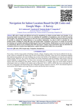
The main aim of this paper is to find accurate navigation inside the closed building using QR codes[1], which provide
user link to the map of indoor location and to provide location details to user and also to hide and provide secured
information about college campus at right place, using Android application. With the help of this application it helps the
user to scan the QR code of the college. Once the Client/User scans the QR code, college campus based on GPS location
will be shown to user in Android application. Figure 1,gives the view of System architecture which includes different
databases, servers, API’s used in navigation process. UofC LDAP is Light Weight Directory Access Protocol which is an
open, industry standards application protocol for accessing and maintaining distributed directory information service over
an Internet Protocol (IP) network. Room finder database which stores all the information about the campus locations and
rooms. Wi-Fi AP data is Wireless Access Points which is a networking hardware device that allows a Wi-Fi compliant
device to connect to a router (via a wired network) as a stand-alone device, but it can also be an integral component of the
router itself. Argis server is Geographical Information System for working with maps and geographical information. It is
used for creating and using maps, compiling geographic data analysing mapped information, sharing and discovering
geographical information, using maps and geographical information in a range of applications and managing geographical
information in a database in a server. Android client is the smartphone used by the user. JNDI is Java Naming and
Directory Interface isa Java API for a directory service that allows Java software clients to discover and look-up data and
objects via a name. Like all, Java API’s that interface with host systems, JNDI is independent of the underlying
implementation. JDBC is Java Database Connectivity is an API for programming language Java, which defines how a
client may access a database. It is a part of Java Standard Edition platform from Oracle Corporation.
SOAP is Simple Object Access Protocol which is a messaging protocol that allows programs to run on desperate OS
(such as Windows and Linux) and to communicate using HTTP (Hypertext Transfer Protocol) and Extensible Mark-up
Language(XML). REST is Representational State Transfer which is an architectural style and an approach to
communicate that is often used in the development of Web Services. The use of REST is often preferred over the more
heavy weight SOAP style because REST does not leverage as much bandwidth, which make it better fit for use over
Internet. The information stored in the directory is passed to Room finder database through JNDI API. The Wi-Fi access
points information is passed to Room finder database which is a Java program. Then, the information from Room finder
database is also passed to Room finder server through JDBC API. The mapped information from Arcgis server is also
sent to Room finder server through SOAP API. Then, all the information from Room finder server is sent to the
smartphone, which stores all the details. The information from Arcgis server can also be directly sent to Android client
through REST API also. Once all this applications are stored in the Android client, it is now ready for navigation process
and the QR code is scanned with the camera in the smartphone. Then the destination path required by the user is
displayed.
II. LITERATURE SURVEY
In [1],it is a mobile application for Android platform with QR codes with reading capability that allows the user to readily
localize, navigate, and view the map of building on their smartphones.QR codes are Two-Dimensional codes where data is
encoded in optically readable format. QR code will be used all across the building to carry information required for the
navigation system. The navigation application in mobile uses the camera to read frames continuously. The location details
from the QR code is used to provide the user his/her current location.
In [2], the indoor positioning system is based on the application of Wi-Fi access points found abundantly in smartphones
and buildings. Wi-Fi’s indoor localization system has least complexity. Thus, the methodology is partitioned into five
steps: Indoor map design, selecting implementation technology, indoor localization development, indoor navigation
integration and feedback display. Wi-Fi has been improved in terms of decreasing the power consumption and the
complexity of design while maintaining the accuracy and speed of the system.
In [3], designing of the indoor map guidance system via the use of portable mobile devices on an indoor campus
environment. It is a mobile application for Android platform with NFC and QR codes. NFC technology is used to find the
shortest path to the selected destination and QR codes are also used in order to determine the current location of the
visitors. The NFC tags and QR codes are distributed with known and readily-accessible positions within the buildings;
and the users of the system can then scan these tags to their current location and subsequently able to access the different
navigation features inside the building.
III. PROBLEM DEFINITION
There are several commercial navigation applications-such as Google maps, Yahoo maps and Map quest that provide user
with direction from one place to another place. However, this applications can search only the existing roads, but they are
not able to provide routes that on-campus path would require. A campus has multiple buildings in its infrastructure. The
people who come to the campus for the first time have a hard time to orientate themselves and find locations. Even if
there are maps at some points on the campus, user cannot get to their destination. The main aim of this paper to find the
accurate navigation inside a closed building using QR code.](data:image/gif;base64,R0lGODlhAQABAIAAAAAAAP///yH5BAEAAAAALAAAAAABAAEAAAIBRAA7)
Recommended
Recommended
More Related Content
What's hot
What's hot (17)
Similar to Navigation for Indoor Location Based On QR Codes and Google Maps – A Survey
Similar to Navigation for Indoor Location Based On QR Codes and Google Maps – A Survey (20)
Recently uploaded
Recently uploaded (20)
Navigation for Indoor Location Based On QR Codes and Google Maps – A Survey
- 1. International Journal of Innovative Research in Information Security (IJIRIS) ISSN: 2349-7009(P) Issue 05, Volume 04 (March 2017) SPECIAL ISSUE www.ijiris.com ISSN: 2349-7017(O) __________________________________________________________________________________________________ IJIRIS: Impact Factor Value – SJIF: Innospace, Morocco (2016): 4.346 ISRAJIF (2016): 3.318 & Indexcopernicus ICV (2015):73.48 © 2014- 17, IJIRAE- All Rights Reserved Page -43 Navigation for Indoor Location Based On QR Codes and Google Maps – A Survey Dr S Ambareesh1 , Tejashwini D2 , Deeksha Reddy S3 , Sangeetha S4 Associate Professor1 , UG Student234 Computer Science and Engineering, Vemana Institute of Technology, Bengaluru-34. Abstract- QR codes is simple and efficient tool used in smartphones to obtain accurate indoor user location. As an increasing number of geo-location services are exploiting the capabilities of smartphones, most of which incorporate GPS location. The smartphones compasses to direct the user to the destination. With the help of accelerometers, it will be possible to estimate the walking distances as an auxiliary information. An, idea in order to calculate the user position inside a building by using QR codes and Google maps. Navigation is the process or activity of accurately ascertaining one’s position, planning and following the route to goal location. Mobile phones are devices merely used to communicate. Based on new techniques like GPS and sensors, compass and accelerometers that can determine the orientation of devices, location based applications coupled with augmented reality views are possible. Keywords: QR codes, GPS, Google maps, Navigation, Smartphones. I. INTRODUCTION Now-a-days, with the rising number of buildings (schools, colleges, shopping malls), it has become difficult for the day– to-day visitors to remember the interior map of each of these places accurately. There may be an information helpdesk that could provide guidance, but some buildings may not have such facility or the helpdesk is not close-by and cannot be readily located. Moreover, the visitors may further lose his/her destination inside the building, while trying to find the nearest helpdesk or map guidance. It is hence more convenient and appropriate if the visitors could simply view the interior map of the building on their phone, wherever and whenever it is needed. There are several indoor navigation technologies which are available in the market such as Bluetooth, Wi-Fi, AGPS or RFID. But every technology has its own sets of advantages and disadvantages that is Bluetooth requires expensive receivers, Wi-Fi also demand expensive access points, RFID requires active tags which are costlier and also they lack in accuracy. Fig 1: System Architecture ANDROID CLIENT Arcgis server Soap Room finder server JDBC JNDI Room finder database UofC LDAP rest/arcgis API Wi-Fi data Java program rest
- 2. International Journal of Innovative Research in Information Security (IJIRIS) ISSN: 2349-7009(P) Issue 05, Volume 04 (March 2017) SPECIAL ISSUE www.ijiris.com ISSN: 2349-7017(O) __________________________________________________________________________________________________ IJIRIS: Impact Factor Value – SJIF: Innospace, Morocco (2016): 4.346 ISRAJIF (2016): 3.318 & Indexcopernicus ICV (2015):73.48 © 2014- 17, IJIRAE- All Rights Reserved Page -44 The main aim of this paper is to find accurate navigation inside the closed building using QR codes[1], which provide user link to the map of indoor location and to provide location details to user and also to hide and provide secured information about college campus at right place, using Android application. With the help of this application it helps the user to scan the QR code of the college. Once the Client/User scans the QR code, college campus based on GPS location will be shown to user in Android application. Figure 1,gives the view of System architecture which includes different databases, servers, API’s used in navigation process. UofC LDAP is Light Weight Directory Access Protocol which is an open, industry standards application protocol for accessing and maintaining distributed directory information service over an Internet Protocol (IP) network. Room finder database which stores all the information about the campus locations and rooms. Wi-Fi AP data is Wireless Access Points which is a networking hardware device that allows a Wi-Fi compliant device to connect to a router (via a wired network) as a stand-alone device, but it can also be an integral component of the router itself. Argis server is Geographical Information System for working with maps and geographical information. It is used for creating and using maps, compiling geographic data analysing mapped information, sharing and discovering geographical information, using maps and geographical information in a range of applications and managing geographical information in a database in a server. Android client is the smartphone used by the user. JNDI is Java Naming and Directory Interface isa Java API for a directory service that allows Java software clients to discover and look-up data and objects via a name. Like all, Java API’s that interface with host systems, JNDI is independent of the underlying implementation. JDBC is Java Database Connectivity is an API for programming language Java, which defines how a client may access a database. It is a part of Java Standard Edition platform from Oracle Corporation. SOAP is Simple Object Access Protocol which is a messaging protocol that allows programs to run on desperate OS (such as Windows and Linux) and to communicate using HTTP (Hypertext Transfer Protocol) and Extensible Mark-up Language(XML). REST is Representational State Transfer which is an architectural style and an approach to communicate that is often used in the development of Web Services. The use of REST is often preferred over the more heavy weight SOAP style because REST does not leverage as much bandwidth, which make it better fit for use over Internet. The information stored in the directory is passed to Room finder database through JNDI API. The Wi-Fi access points information is passed to Room finder database which is a Java program. Then, the information from Room finder database is also passed to Room finder server through JDBC API. The mapped information from Arcgis server is also sent to Room finder server through SOAP API. Then, all the information from Room finder server is sent to the smartphone, which stores all the details. The information from Arcgis server can also be directly sent to Android client through REST API also. Once all this applications are stored in the Android client, it is now ready for navigation process and the QR code is scanned with the camera in the smartphone. Then the destination path required by the user is displayed. II. LITERATURE SURVEY In [1],it is a mobile application for Android platform with QR codes with reading capability that allows the user to readily localize, navigate, and view the map of building on their smartphones.QR codes are Two-Dimensional codes where data is encoded in optically readable format. QR code will be used all across the building to carry information required for the navigation system. The navigation application in mobile uses the camera to read frames continuously. The location details from the QR code is used to provide the user his/her current location. In [2], the indoor positioning system is based on the application of Wi-Fi access points found abundantly in smartphones and buildings. Wi-Fi’s indoor localization system has least complexity. Thus, the methodology is partitioned into five steps: Indoor map design, selecting implementation technology, indoor localization development, indoor navigation integration and feedback display. Wi-Fi has been improved in terms of decreasing the power consumption and the complexity of design while maintaining the accuracy and speed of the system. In [3], designing of the indoor map guidance system via the use of portable mobile devices on an indoor campus environment. It is a mobile application for Android platform with NFC and QR codes. NFC technology is used to find the shortest path to the selected destination and QR codes are also used in order to determine the current location of the visitors. The NFC tags and QR codes are distributed with known and readily-accessible positions within the buildings; and the users of the system can then scan these tags to their current location and subsequently able to access the different navigation features inside the building. III. PROBLEM DEFINITION There are several commercial navigation applications-such as Google maps, Yahoo maps and Map quest that provide user with direction from one place to another place. However, this applications can search only the existing roads, but they are not able to provide routes that on-campus path would require. A campus has multiple buildings in its infrastructure. The people who come to the campus for the first time have a hard time to orientate themselves and find locations. Even if there are maps at some points on the campus, user cannot get to their destination. The main aim of this paper to find the accurate navigation inside a closed building using QR code.
- 3. International Journal of Innovative Research in Information Security (IJIRIS) ISSN: 2349-7009(P) Issue 05, Volume 04 (March 2017) SPECIAL ISSUE www.ijiris.com ISSN: 2349-7017(O) __________________________________________________________________________________________________ IJIRIS: Impact Factor Value – SJIF: Innospace, Morocco (2016): 4.346 ISRAJIF (2016): 3.318 & Indexcopernicus ICV (2015):73.48 © 2014- 17, IJIRAE- All Rights Reserved Page -45 IV.EXISTING SYSTEM The existing system gives the user his/her current location and also provide directions to particular destination for outdoor location. There is a limitation for smartphones to locate their exact positions in covered areas such as shopping malls, airports, colleges, schools etc. The indoor navigation systems are: QR code to carry information required for navigating system. Wi-Fi indoor localization system to access points in the building with the least complexity. NFC technology in order to provide shortest path to selected destination. Bluetooth ,RFID, AGPS technologies are also used. The indoor navigation systems available in the market are too expensive and it lacks to provide reliability. V. PROPOSED SYSTEM The proposed system will provide quick and easy navigation as it is using QR code. The indoor navigation will be very accurate using QR code. Designing an App with QR code called Campus Navigator which is used for navigating within the college campus. The accelerometers, navigators, QR code which helps for wide range of networking. QR code will be used across the building to carry information required for navigating system. The mobile application will scan the QR codes to provide accurate indoor navigation for users. VI.DESIGN This design approaches include Data flow diagrams, project plan. Fig 2: Level 0 Dataflow diagram Fig. 2, shows the Level 0 data flow diagram which indicates the steps that take place during navigation. The input is given by the user i.e, the destination location. Then, the input given by user is processed i.e, to check the location given and if the processed value of input is valid. The output path is displayed to the us Fig 3: Level 1 Dataflow diagram Fig. 3, shows the Level 1 data flow diagram of navigation in detail. As mentioned in figure 2 the input is the destination location, then it is validated. Meanwhile, the Server Provide Path which stores all the mapped information of the campus, provides its information to the Process Tester. Where in the Process Tester, checks the map of the location and the address of the location. Once, the validated result comes out to true. Then, the path required by the user is displayed in order to reach his/her destination c c Input as a Destination Address Output as a Path Processing Input Parse the Input Parameter s Input As a Destination Address Server Provide Path Process the Input Address Processing Input Output Output as a Path
- 4. International Journal of Innovative Research in Information Security (IJIRIS) ISSN: 2349-7009(P) Issue 05, Volume 04 (March 2017) SPECIAL ISSUE www.ijiris.com ISSN: 2349-7017(O) __________________________________________________________________________________________________ IJIRIS: Impact Factor Value – SJIF: Innospace, Morocco (2016): 4.346 ISRAJIF (2016): 3.318 & Indexcopernicus ICV (2015):73.48 © 2014- 17, IJIRAE- All Rights Reserved Page -46 Fig 4: Project plan Fig. 4, shows the steps involved in project plan. Initial step is to Start. Second step, Requirement analysis like Hardware and software requirements analysis. Third step, Design of the Project i.e, designing the structure of project like designing the floor plan, generating way points, navigating etc. Fourth step, Coding and Implementation for navigating to the location. Fifth step, GUI Development which is Graphical User Interface that helps in order to generate user friendly icons, widgets etc. Sixth step, Testing of the applications used such as Indoor atlas, QR codes etc. Then, checking Boolean condition “If”. If the result is true, then the next step is output. Or if the result is false, Then again, the modification is done for the particular applications, tested and finally the output is retrieved. The final step is End. VII. METHODOLOGY When approaching QR CODE TO TRACK THE CAMPUS INFORMATION there are four common methodologies used: Create location and floor plan. Map location Manage map data Build App. Modification IF Testing Deployment Start Requirement Gathering and Analysis Design of the Project Coding GUI Development I End true false
- 5. International Journal of Innovative Research in Information Security (IJIRIS) ISSN: 2349-7009(P) Issue 05, Volume 04 (March 2017) SPECIAL ISSUE www.ijiris.com ISSN: 2349-7017(O) __________________________________________________________________________________________________ IJIRIS: Impact Factor Value – SJIF: Innospace, Morocco (2016): 4.346 ISRAJIF (2016): 3.318 & Indexcopernicus ICV (2015):73.48 © 2014- 17, IJIRAE- All Rights Reserved Page -47 CREATE LOCATION AND FLOOR PLAN: Steps to be followed to create location and floor plan Create Account- Account must be created Indoor atlas website to create location and floor plan. Create location- once registered with Indoor atlas, on desktop enter Url http://.indooratlas.com and login with registered credentials to create location and create the location by adding location address, latitude and longitude. Upload Floor plan- once location is created, floor plan image should be uploaded on to the world map by providing floor plan, floor number. MAP LOCATION: Use Map Creator mobile App to access floor plans and collect sensor data throughout the venue. The collected data is uploaded to Indoor atlas cloud where a land space of the sensor reading in the venue is created for the positioning algorithm. Steps to be followed to access floor plans and collect sensor data throughout venue Select Floor plan- login with Indoor atlas account details in Map Creator mobile App to select floor plan, after login procedure select the floor plan among multiple floor plans which you want to set the route. Calibrate phone- the Android mobile should be calibrated so that by utilizing the built-in magnetic sensor with in a smartphone, which helps to detect the anomalies in the Earth’s magnetic field to accurately pinpoint and track a person’s location indoors, producing a “blue dot” on a map- just like GPS. Set route- once mobile gets calibrated, add waypoints on the floor plan and start Mapping and record the mapping. MANAGE MAP DATA: While sensor data is being collected via user’s mobile App, service is constantly analyzing this data to generate an updated look-up map analysis of the look-up map can be viewed in a user’s web portal. It shows how well the positioning is going to work on the site. Publishing the updated look-up map version is just a simple click. Steps to be followed to access floor plans and collect sensor data throughout the venue: Review map data. Analyze map quality. Publish Indoor maps. BUILD APP: Once Map gets generated. The user can simply generate an API key and use SDK for iOS and Android provided by Indoor atlas platforms to add locations-based features to the mobile App. API communicates with the positioning service that computes the device location and returns it back to the user’s mobile App as a GPS coordinates. Steps to be followed to access floor plans and collect sensor data throughout the venue: Integrate QR code. Generate API key. Integrate Indoor map. Subscribe Service The functional requirements includes: College Admin- Register to the Web by Providing Admin details like Name, Gender, City, Phone No, Email id,etc. Login with username and password. Provide Campus information(departments, library,etc). Provide College QR code. Clint/User- Download the App name on his/her mobile. Register to the App by providing the user details like Name, Gender, City, Phone No, Email id, etc. Login with username and password. Select the QR code Scanner Icon in the App. Scan the QR code through the App camera. Campus Map based on GPS with search Icon will display where one can select particular place in the campus. Enter the required place in search box and then it shows the directions to that place. User will get Popup message for all the surroundings like classrooms, library, etc. Once the user reach the particular place which he/she has selected, the App displays the final Popup message and application stops showing the further direction. Hence, the user reaches the destination.
- 6. International Journal of Innovative Research in Information Security (IJIRIS) ISSN: 2349-7009(P) Issue 05, Volume 04 (March 2017) SPECIAL ISSUE www.ijiris.com ISSN: 2349-7017(O) __________________________________________________________________________________________________ IJIRIS: Impact Factor Value – SJIF: Innospace, Morocco (2016): 4.346 ISRAJIF (2016): 3.318 & Indexcopernicus ICV (2015):73.48 © 2014- 17, IJIRAE- All Rights Reserved Page -48 CONCLUSION AND FUTURE ENHANCEMENT The conclusion is that this approach is cost effective for service provider. Users do not have to make any investments for indoor navigation. Complexity and time to implement is less. There is no additional configuration which the users have to maintain for indoor navigation. The main aim of this paper is to give the exact location of covered areas. As future work, we intend to use smartphone compasses to direct the user to the destination. With the help of accelerometers, it will be possible to estimate the walking distances as auxiliary information. REFERENCES [1]. Shailee, Pramodh B S, Deepa S R “QR code based navigation system for closed building using smartphones” IEEE 2016. [2]. Wong Joanne, Sanna Taking, Nazrin Isa, KokChao “Indoor navigation and localisation application system” IEEE 2016. [3]. Omran Al Hammadi, Ahmed Al Hebsi, M Jamal Zemerly, Jason W P Ng “Indoor localisation and guidance using portable smartphones” IEEE 2012. [4]. JosymolJoseph “QR code based indoor navigation with voice response” IEEE 2014. [5]. WatthanasakJeamwatthanachai, MikeWald, Gary Wills “Map data representation for indoor navigation” IEEE 2016. [6]. David Conde-Lagoa, Francisco J Gonzalez-Castano, Felipe Gil-Castineira “QR maps: an efficient tool for Indoor user location based on QR codes and Google maps” IEEE 2011.