
Recommended
Recommended
More Related Content
What's hot
What's hot (20)
Viewers also liked
Similar to Petone Spatial Plan Community Consultation Boards 24-1-2017
Similar to Petone Spatial Plan Community Consultation Boards 24-1-2017 (20)
More from Council2016
More from Council2016 (10)
Recently uploaded
Recently uploaded (20)
Petone Spatial Plan Community Consultation Boards 24-1-2017
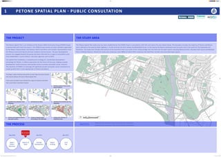
- 1. 0 100 200 500mN The Petone Spatial Plan is an initiative of the Petone 2040 Community Group (P2040 Group) in partnership with Hutt City Council. The P2040 Group consists of seven members appointed by the Mayor, Deputy Mayor and Harbour Ward Councillors and includes representation from the Petone Community Board and local residents and businesses. The plan development process has engaged beyond this group and been informed by a range of consultation with local stakeholders, council officers, and other agencies such as NZTA. The Spatial Plan establishes a comprehensive strategy for coordinated development and design for Petone. It reflects aspirations for the future of the area, helping to guide development, build consensus and provide clarity to private and public sector interests. The intention of P2040 is to leverage off significant private and public sector investment to enable growth that is most appropriate to Petone and Moera. The Stage 1 report evidence base points to seven high level key principles that should underpin the future Petone Spatial Plan. These seven principles have informed the range of initiatives described later across these consultation boards. 1 PETONE SPATIAL PLAN - PUBLIC CONSULTATION THE PROJECT THE STUDY AREA THE PROCESS NOTES Stage 1 Report (Baseline) Options & Ideas Concept Development Report Drafting Final Plan May 2016 Feb 2017 Mar 2017 We are here! The Petone Spatial Plan study area has been established by the P2040 Group in consultation with HCC and covers the area shown below. The boundary includes the majority of Petone and Moera and is defined to the west by State Highway 2, to the north by the Hutt railway line/Wakefield Street, to the east by the Moera settlement and rail yards and to the south by The Esplanade and foreshore. The study area includes that section of the Hutt River that runs south of the railway bridge near Ava Park and the open spaces including Memorial Park, Shandon Golf course and McEwan Park in Hikoikoi Reserve. Overall the study area comprises some 480Ha of which 93Ha comprises the Hutt River corridor and associated open spaces. Please feel free to append a post-it note below with anything you would like us to know about. These will be collected and recorded. 1 Reinforce Jackson Street as the heart of Petone. 2 Establish three attractive Town Gateways. 3 Intensify key corridors. 4 Revitalise the foreshore and The Esplanade. 5 Enhance and augment Petone’s open green spaces. 6 Create an Amenity Spine connecting to The Esplanade. 7 Enhance the character of traditional areas. The Esplanade Waione Street Jackson Street Wakefield Street Victoria Street PetoneRec Udy St CubaStreet WilliamStreet PatrickStreet ScholesLane NevisStreet BritanniaStreet Bouverie Street Whites Line West Randwick Cres Tirangi Road YorkStreet BuickStreet RandwickRoad Hutt Road Gear Island (Shandon Golf Course) Hutt Park Hikoikoi Reserve M cEw an Park Honiana Te Puni Reserve NorthPark Petone Spatial Plan_Community Consultation Boards_24 Jan 2017_A0.indd 1 24/01/2017 2:38:55 PM
- 2. 2 UNDERSTANDING THE PLACE The Stage 1 Preliminary Study produced several layers of analysis, including Streetscape Quality, Movement Networks, Land Use Patterns, Historic Street Pattern Development, Character and Heritage, Strategic Infrastructure Networks, District Plan Analysis, and Stakeholder Consultation feedback. A selection of these diagrams are reproduced here, and are available in more detail in the Stage 1 report which can be accessed online, or there are several copies available today. 17 P2040 GROUPP����� Preli�inary �tudy for a Petone ��a�al Plan April 2016 Blocks that undergo future change Blocks that are in existence today 17 P����� Preli�inary �tudy for a Petone ��a�al Plan Blocks that undergo future change Blocks that are in existence today Visual Quality Assessment STAGE 1 ANALYSIS The Stage 1 Preliminary Study provides a baseline analysis of the Petone study area identifying issues, opportunities, and high level principles. These are reflected in a Strategic Opportunities diagram (below) and the set of seven spatial principles described on Board 1. To date these ideas have emerged through engagement with local stakeholders, the P2040 Group, Hutt City Council, other agencies and the range of analyses described throughout the Stage 1 report. Of particular relevance to Petone are issues around natural hazards. Different hazard types (seismic, storm, liquefaction, sea level etc.) overlap to varying degrees suggesting areas having a low, medium, or high risk. This categorisation is subject to ongoing evaluation with GNS Science and HCC. Strategic Opportunities CHARACTER APPROACH Given the unique history and heritage across Petone, Stage 1 undertook a Character Areas study that identified the parts of Petone that exhibit consistent and coherent characteristics. Each area is described in detail in the Stage 1 report. From this base, a Townscape Sensitivity drawing was produced that identifies the sensitivity of areas in relation to change and categorises them as Critical, Constant, or Tradeable. In broad terms, it has been found that areas of earlier development tend to be the areas of higher townscape quality (Critical or Constant). This is because they tend to contain a higher concentration of architecturally noteworthy buildings, spatial patterns with a strong sense of identity and cohesiveness. Commercial/Industrial 1a Big Box retail and office 1b Big Box retail 2a Small grain light industrial 2b Mixed light industrial 2c Single site industrial Residential 3a South of Jackson 3b South of Jackson 4 Petone Rec 'frame' 5 Riddlers Cres historic 6a North of Jackson 6b Ava Station area 7a Northern Moera 7b Southern Moera 8a Multi-unit residential 8b Multi-unit residential Mixed Use 9 Cuba St area 10 Jackson St Area Character Areas Hazard Mapping Graphic Overlay Townscape Sensitivity Street Hierarchy Historic Street Pattern District Plan Controls Initial Consultation OutcomesStrategic Infrastructure Heritage Assets Land Use Patterns Petone Spatial Plan_Community Consultation Boards_24 Jan 2017_A0.indd 2 24/01/2017 2:39:11 PM
- 3. Residential Intensification Drawing Key Public open space CVL parkway landscape Streetscape treatment Wetland regeneration River recreational pathways Fault line and building setback Mixed use commercial Fine grain industrial Education/institutional Suburban commercial Mixed use residential intensification Traditional character housing area Traditional character industrial area 0 100 200 500mN 2 22 7 2 6 AN OVERALL SPATIAL PLAN The Petone Spatial Plan will provide an overall strategic direction for Petone. This plan will comprise of a number of project initiatives addressing the issues identified in the baseline analysis. To date some 15 initiatives have been identified that are listed below, and described across the remaining boards. The District Plan and HCC strategy sets out expectations for residential growth to accommodate housing demand and demographic change, and in addition several significant infrastructure projects are anticipated for the Hutt Valley. The Spatial Plan therefore provides the opportunity to integrate these requirements in a way that ensures the best outcome for the Petone and Moera community. 3 PETONE-WIDE PROPOSALS 1 TRADITIONAL CHARACTER AREAS 2 STRATEGIC INFRASTRUCTURE Petone has a significant portion of cohesive character housing and fine grain light industrial development that plays a large role in defining the character of the area as a whole. This initiative looks to establish areas where housing or industrial character is coherent and of architectural merit and manage change and intensification in these areas. To do this will require special recognition of these areas in the District Plan where some activities will be controlled while still allowing for reasonable change and development of individual properties in these areas. Recognising the importance of the traditional industry areas, for both their built character and their role in the economic landscape of the Hutt Valley is important and this initiative addresses retention of these areas, their density, fine grain and diversity of function. Two major infrastructure projects, the Petone to Grenada (P2G) link, and the Cross Valley Link (CVL), will increase the accessibility and regional significance of Petone. This initiative addresses the design of a future CVL, and proposes an alignment along Wakefield St and the rail line, meeting the Wainuiomata route, and through the rail yards to connect with Seaview/ Gracefield. The initiative also proposes the idea of CVL as a parkway that mitigates traffic impact and creates a new gateway and ecological corridor east-west across Petone. State Highway 2 (SH2) Proposed Petone to Grenada Link (P2G) Cross Valley Link (CVL) The Esplanade Wainuiomata Road Wainui Road Seaview Road Cambridge Terrace 2 22 7 2 22 7 2 6 1. Traditional Character Areas 2. Strategic Infrastructure 3. Petone West Gateway Area 4. Hutt Road + Petone Station 5. The Esplanade INITIATIVES 6. North Park Precinct Gateway Area 7. Central Jackson Street 8. Cuba Street Axis 9. Amenity Corridor 10. Petone Rec + Frame 11. Petone East Gateway Area 12. Randwick Road + Moera 13. Hutt River Corridor 14. Jackson Street East 15. Te Mome Boat Sheds Roading Infrastructure Network Traditional character areas CVL ‘Wakefield St alignment’ CVL ‘Rail yard alignment’ The emerging spatial plan Petone Spatial Plan_Community Consultation Boards_24 Jan 2017_A0.indd 3 24/01/2017 2:39:40 PM
- 4. 4 PETONE WEST 2 22 7 2 6 2 22 7 2 6 2 22 7 2 6 3 PETONE WEST GATEWAY AREA 4 HUTT ROAD + PETONE STATION 5 THE ESPLANADE 2 22 7 2 6 The Petone West Gateway Area is a significant area in a number of ways. It is the historical location of both the Te Tatau o te Po and Pito One villages as well as the current Te Puni Urupa and is strategically located at the western ‘entrance’ to Petone. However perhaps in contrast to both this cultural importance and strategic location, the area is characterised by a poor public open space structure and relatively low- grade ‘big-box’ retail. Plan Change 29 has had limited success in delivering the intended vibrant ‘mixed use’ precinct envisaged by the District Plan. The proposed P2G Link will increase development opportunity. The utilitarian character of Hutt Rd detracts from the gateway experience entering Petone while the connections between Jackson Street and Petone Station are poor. The station environment itself is in need of improvement. This initiative proposes a comprehensive streetscape upgrade that may allow for new roading in conjunction with the CVL and including planting, surface treatment, street furniture and local improvements to building frontages. The initiative also outlines enhancements to the Petone station and proposes a new ‘station square’, associated development and connections to Jackson St. This initiative provides a high-quality waterfront boulevard with improved pedestrian amenity in conjunction future roading changes as part of the CVL project. The initiative recommends creating three character sections along The Esplanade - a formal urban waterfront in the centre, and softer ecological edges at Honiana Te Puni, and Hikoikoi reserves. The initiative includes the retention of character housing within a ‘Central Spatial Frame’, with some intensification to either side to redefine the street frontage and townscape of this area. The initiative proposes the introduction of a new street network, block structure and open spaces to create stronger connections to and within the area and a more coherent urban form. Such a plan requires partnership and ‘buy-in’ from land owners and operators in the area. The location of new infrastructure projects reinforces Petone West’s important strategic location. Proposed stage 1: ‘Better Mega-Centre’ with optimised vehicle access and parking. Proposed stage 2: New streets and smaller blocks supporting intensified development and access. This stage would include investment in high-quality public open space (including an improved setting for the urupa). Enhanced connections between Jackson Street and The Esplanade. Diversified uses include retention of light industry. 2 22 Petone Spatial Plan_Community Consultation Boards_24 Jan 2017_A0.indd 4 24/01/2017 2:41:39 PM
- 5. 5 PETONE CENTRAL 2 22 7 2 6 6 NORTH PARK PRECINCT 2 22 7 2 6 The North Park Precinct is identified as a location for more intensive mixed use development. The current land use in the area is predominantly industrial and ‘big-box’ retail which could be considered as a potential land bank for comprehensive change in the future. In order to achieve the residential and mixed-use function proposed for the area, this initiative proposes a new street pattern and introduces smaller, more regular blocks to increase connectivity and enhance access. In the short to medium term the plan proposes to retain some of the existing development but improve the quality of the public realm and on- site open spaces. As land values and aspirations change over time the longer term vision for North Park could be realised. New bridges over Cuba and Victoria Streets improve links to Alicetown, provide additional amenity to the area, encourage a vibrant mix of uses and stitch Petone back into Lower Hutt. A proposed new railway station and integrated bus interchange will encourage development in the area and support more intensive residential development. A new sports hub development and other community uses have the potential to add to an already amenity-rich area and create quality public spaces and activities. 2 22 7 2 6 2 22 7 2 6 7 CENTRAL JACKSON STREET 8 CUBA STREET AXIS This initiative proposes a heritage themed streetscape upgrade, improving pedestrian access and amenity. It also proposes to retain the familiar retail/residential patterns in the area, but advocates for more effective application of District Plan design controls including the Area 1 Design Guide. The initiative includes the concept of a ‘Spatial Frame’ applied to the traditional housing area south of Jackson St that restricts height within the Frame and protects sea views from the apartment buildings on Jackson St, encouraging quality residential investment and protection of heritage assets. This initiative proposes a new ‘avenue’ streetscape treatment with a more symmetrical and consistent cross-section. Cuba St is identified as an axis for intensification with a mix of uses - including higher density residential. The current ‘suburban commercial zones’ are proposed to be removed in favour of a Cuba St-wide zoning. Important intersections, such as at The Esplanade, Jackson St, Udy St, are upgraded and the connection to Alicetown is improved. 2 22 2 22 Retention of some existing usesExample of possible end-state development The 3D views below do not constitute designs for buildings or the Sportsville complex, but illustrate the potential of the proposed block arrangements. Petone Spatial Plan_Community Consultation Boards_24 Jan 2017_A0.indd 5 24/01/2017 2:42:22 PM
- 6. 6 PETONE CENTRAL 9 AMENITY CORRIDOR 10 PETONE REC + FRAME 2 22 7 2 6 The Amenity Corridor is a high quality north-south thoroughfare from The Esplanade / foreshore to Alicetown that is intended to be pedestrian oriented, to compliment the Cuba St Axis. Buick St is host to many public amenities, however these are currently poorly connected. The amenity corridor initiative reconnects these as well as providing enhanced settings for the Settlers’ Museum, Artesian Well, the Petone Rec’s Memorial Gates, and a pedestrian connection through to Alicetown. 2 22 7 2 6 2 Petone Rec has been identified as Petone’s Green Heart; a civic landscape with unique heritage value. This initiative looks to protect that, and foster the idea of a multifunctional “Village Green” at The Rec and introduce a generous promenade as part of the amenity corridor initiative. The surrounding subdivision pattern is characterised by larger lots with higher incidence of institutions (WelTec) and multi-unit residential developments than elsewhere in Petone. The plan aims to protect the character and amenity of high-value traditional housing, while still encouraging high-quality redevelopment of larger residential (multi-unit) sites. To achieve this, new development would need to be subject to locally-nuanced design guidelines and effective HCC design review. WelTec will continue to offer courses in Petone and will see a gradual upgrade and development of their campus to increase access through the campus as well as providing a better connection and ‘face’ to both Cuba St and Petone Rec. 2 22 7 2 6 The initiative is characterised by a two-way slow street with less parking and stronger pedestrian orientation. A consistent landscape treatment with an intensively planted median reinstates the loss of amenity that Buick St has sustained in the past. The amenity corridor continues through Petone Rec with a generous promenade and cycleway along eastern side. The corridor has the potential to extend across Udy Street into North Park Precinct, creating a link to Alicetown and providing additional access and connection to a proposed sportsville hub. The 3D view below does not constitute a design for streetscape treatment but is simply an illustration of the connection of open green space from the foreshore north. Amenity corridor pathwaySample Streetscape Precedents Recreation Ground Promenade precedentsMix of activities Existing conditions in and around The Rec Petone Spatial Plan_Community Consultation Boards_24 Jan 2017_A0.indd 6 24/01/2017 2:42:53 PM
- 7. 7 PETONE EAST 2 22 7 2 6 11 PETONE EAST GATEWAY AREA 2 22 7 2 6 Petone East is characterised by light industrial uses and is negatively affected by the volume and type of traffic along The Esplanade and Waione Street. The area has a strong east-west orientation with low north- south permeability. This initiative introduces a more coherent and connected block structure, primarily introducing new north-south streets and lanes. The existing industrial uses are important for Petone as they offer employment functions while consideration should be given to allowing for new high-tech business accommodation. In addition to the commercial/industrial development in the area, the initiative proposes intensive residential development along the waterfront edges to make the most of the high amenity at those locations. The initiative sees Petone East as ‘Silicon Valley’ meets ‘Home of Small Business’ allowing for a mix of uses and a more vibrant area in conjunction with the ‘detuning’ of The Esplanade/Waione Street. The areas around Te Mome stream and Hikoikoi Reserve will be enhanced to provide more public access, activities and provide greater ecological benefit to the area. Strong streetscape treatment on the proposed north-south streets increases legibility of the natural borders to the site, with Te Mome Stream to the north and Hikoikoi Reserve to the south. 12 RANDWICK RD + MOERA 2 22 7 2 6 2 22 7 2 6 Randwick Road’s function as a Major Distributor causes severance within Moera that would be exacerbated were the CVL to utilise Randwick Rd as a connector to Seaview. This initiative and the ‘Strategic Infrastructure’ initiative (2) proposes a route along the rail corridor adjoining the rail yards that would lessen the heavy traffic load on Randwick Road and present the opportunity for traffic calming and a much higher quality pedestrian environment. This in turn enhances the ‘village’ quality and heritage character of Moera. The initiative retains the diverse functions along Randwick Rd but introduces a more cohesive streetscape approach. An asymmetric streetscape treatment that consists of a line of street-tree scale planting, or similar, to the eastern side of Randwick Rd and avenue planting of east-west streets to the western side to accentuate the pedestrian connections to the river corridor. Residential intensification on the western side of Randwick Rd provides for more housing while retaining the traditional character of the existing area. Redevelopment to part of York Park and the northern edge of Hutt Park is also considered to include new housing and provide a higher quality, well surveilled / safer public open space. Indicative York Park development and upgradeAsymmetric street types Petone Spatial Plan_Community Consultation Boards_24 Jan 2017_A0.indd 7 24/01/2017 2:43:51 PM
- 8. 8 PETONE EAST 13 HUTT RIVER CORRIDOR 2 22 7 2 6 2 22 7 2 6 14 JACKSON STREET EAST 15 TE MOME STREAM + BOAT SHEDS ‘Jackson Street East’ refers to the section of Jackson St to the east of Cuba St, through to Te Mome Stream. Currently there is a clear commercial/residential boundary at Cuba St and a low quality termination point towards the old Unilever factory. Housing New Zealand accommodation dominates parts of this area. This initiative identifies Jackson St East as an axis for primarily residential intensification, making the most of the proximity to the open space of the golf course and amenity of Te Mome Stream. Te Mome Stream runs along the western edge of the Shandon Golf course (Gear Island) but narrows towards the outlet into the Hutt river. This initiative, and Petone East Gateway, proposes to widen this section of the stream, and provide a wider open space to form part of the Hutt River Trail. This would include a board walk and environmental programme giving increased access to the boat sheds and improved pedestrian bridge access. The boat sheds will be retained and the area surrounding them will be enhanced, with the possibility of new fine grain residential to make the most of the location. 22 2 22 2 22 7 2 6 The Hutt River enjoys a strategic location within the network of regional recreational pathways and falls under part of a wider strategy that seeks to re-orient Hutt City to the river. Ongoing flood control and stop bank work provides the catalyst for landscape improvements and the replacement of the Ava rail bridge (as part of a CVL project or not) creates an opportunity for a better cross-river link. The initiative provides more frequent public access to the water edges, and ensures the quality and safety of these connections. Improved recreational circuits are proposed linking amenities on both sides of the river and an eco-themed redevelopment of Hikoikoi Reserve. These pathways link in with both the Hutt River Trail and the Great Harbour Way trails making Petone a strategic link between the two. On Gear Island (Shandon Golf Course), the initiative proposes storm water retention ponds and wetland regeneration areas within the course as a means of dealing with stormwater and flooding for the rest of the Petone area. Finally the initiative identifies the need for a feasibility study for high-density housing along parts of the corridor that tests how housing might be developed in flood-risk areas. 2 22 7 2 6 Recreational Pathways Wetland and storm-water retention Te Mome boat sheds Great Harbour Way Image from Boffa Miskell report (2009) Great Harbour Way Image Ian Stantial Hutt River Trail Petone Spatial Plan_Community Consultation Boards_24 Jan 2017_A0.indd 8 24/01/2017 2:44:44 PM