1. !
!
!
!
!
!
!
!
!
!
!
!
!
!
!
!
!
!!!!!!!!!!!!!!!!!!!!!!!!!!!!!!!!!!!!!!!!!!!!!!!
!!!!!!!!!!!!!
!
!
!
!!
!
!
!
!
!
!
!
!
!
!
!
!
!
!
!
!
!
ÜF
á
á
á
á
á
á
á
á
á
á
á
¹ ¹
¹
ÜF? ?
ÜM??
15
16
22
10
13
66
5
55
25
14
7
5
9
15
12
404500
404500
404750
404750
405000
405000
405250
405250
405500
405500
5181500 5181500
5181750 5181750
5182000 5182000
5182250 5182250
250 0 250125 Meters
A
A'
l
North
Cross-Section A-A'
Map of
Slate River, Michigan
Author: Austin Fisher
Class: GE 3910 Field Geology
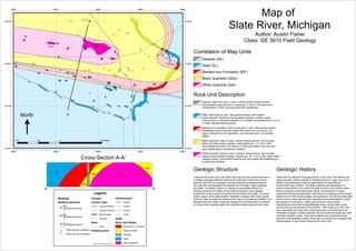
Rock Unit Description
Diabase- Mafic and dark in color, medium grained ophitic texture,
holocrystaline grain structure, crystals are 1-3mm in size and has a
mineralization of 80% pyroxene and 20% plagioclase.
Slate- Black-grey in color, fine grained texture, well-foliated
metamorphism, bedding is sub-parallel to foliation surface, easily
fractured with a hardness between 3-4, multiple color bands from 2-10 cm
in width indicate bedding planes.
Banded Iron Formation- Red to dark grey in color, fine grained texture,
interbedded brown-red chert layers with dense iron rich layers, red
layers oxidized iron rich deposition, and fractures with a conchoidal
pattern.
Black Quartzite- Black in color, medium coarse texture, sub-rounded
black and white quartz crystals, crystal grains are .5-1 mm in size,
conchoidally fractured, and matrix is a dark grey wacky color and has
grey weathering on unfractured surfaces.
White Quartzite- White in color, medium coarse texture, sub-rounded
opaque quartz arenite crystals, crystals are .25-1 mm in size, clean matrix
between grains, conchoidal fracturing and red powder like weathering on
un-fractured surfaces.
Geologic History
There are five different rock types shown in this map, the oldest is the
white quartzite. White quartzite is Paleoproterozoic in age, due to the
visible cross-bedding as well as ripple marks the depositional
environment was a beach. The black quartzite was deposited in a
similar environment to the white quartzite but due to the darker matrix
there is indications that there were higher concentration of muds
suspended during the deposition. Next there is a deeping of the oceanic
beach environment where greater concentrations of muds are deposited
and iron from ocean plumes were deposited and precipitated to create
the banded iron formation. Slate was formed in a low energy
depositional environment probabilistically under similar deep ocean
environment as the banded iron formation. After these four rock units
were deposited they were then metamorphosed and folded from the
Penokean orogeny, collision between the microcotinent south and north
Archeian Superior craton. This event explains the overall east-west
anticline of the geology. Finally, there was an intrusion of a diabase dike,
Keweenawian in age, which crosscuts the rock units.
Geologic Structure
There are five main rock units within this map and the overall structure is
a shallow plunging anticline towards the southeast. Within the overall
anticline fold there is a parasitic syncline towards the easterly edge of
the map that encompasses the banded iron formation, black quartzite
and slate. In addition, there is a change of sub-parallel foliation to
bedding towards the middle of the anticline fold and much steeper
towards the south contact of banded iron formation and slate. This axial
planer nature of the slate foliation indicates a steeper limb of the overall
anticline. Next, through the center of the map, on a heading of N80W, is a
diabase dike that visibly crosscuts, banded iron formation and is inferred
to crosscut the overlying slate and underlying black quartzite rock units.
Legend
Bedding
Bedding Symbols
ÜF??
Inferred Anticline
ÜM? ?
Inferred Syncline
ÜFPlunging Anticline
á
Strike and Dip of Bedding
¹Strike and Dip of Foliation
Contact
Contact Type
Contact Certain
Contact Inferred
Map Boarder
Outcrop
River
River
Infrastructure
Infrastructure
Bridge
Colvert
Roads
! ! !
Trails
Units
Rock Unit Visible
Banded Iron Formation
Black Quartzite
Diabase
Slate
White Quartzite*Lighter colored units are inferred
17
21
Correlation of Map Units
Diabase (Db)
Slate (SL)
Banded Iron Formation (BIF)
Black Quartzite (Qtzb)
White Quartzite (Qtz)
A A'
SL BIF Db Qtzb Qtz
Qtzb
Qtzb
BIF