
Recommended
Recommended
More Related Content
What's hot
What's hot (11)
Similar to Site Plan for Rathmalana Railway Station - Amali Pathiraja
Similar to Site Plan for Rathmalana Railway Station - Amali Pathiraja (20)
Recently uploaded
Recently uploaded (20)
Site Plan for Rathmalana Railway Station - Amali Pathiraja
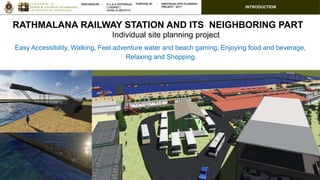
- 1. INTRODUCTION Easy Accessibility, Walking, Feel adventure water and beach gaming, Enjoying food and beverage, Relaxing and Shopping RATHMALANA RAILWAY STATION AND ITS NEIGHBORING PART Individual site planning project
- 2. INTRODUCTION underserved settlement Temporary bus Stand Railway Station Temporary three Wheel Park ? 2017 2020 Prevailing trend and pattern Available Issues need to address Public Perceptions Key reason : Not having highest and best use of the site, So having development potential Justification on need a planning and design intervention PROPOSALS FOR Available Issues need to address Public Perceptions Prevailing trend and pattern Source : Google maps Redevelopment of railway stations along the Coastal line Marine drive project Colombo Suburban Railway Project
- 3. Selected Scenario Alternative Evolution Project A- Community improvement project Project B- Recreational based transport project Project C- Tourism based project Project D- Commercial based project Project E- Proposed project by Urban Development Authority Selection Criteria Considered factors Project A Project B Project C Project D Project E Legally Permissible UDA regulation Other related acts Financial Feasible Net Present Value [2047] Rs. 744,074 Rs. 13 million Rs. (48 million) Rs. (31 million) Rs. (46 million) Break even point 27 years 23 years >30 years >30 years >30 years Physically Possible As mentioned Socially Acceptable Survey Land use compactible Compatibility and conflict Alignment with objective of the client Client objective
- 4. UDA Regulation Adopted for the Design Plot coverage Plot coverage 60% Built-up 40% Open space 60% No of Floors -1 FAR – 0.53 Land Extent 3.78 Acres Site Extent 5.16 Acres + Sea Main Access Road Station Road Width of the Main Access Road 4.2m Client / Ownership Ceylon Government Railway(CGR) Plot coverage 60% - Built-up 40% - Open space Rare Space = 3m Need to Be : Road width = 4.5 m Commercial area -6478.2483 sq.m. Commercial use _ FAR – 0.53 Commercial use _No of Floors -1 Road Frontage = 6m Building Line = 12.19m (40 feet)
- 5. Coast Conservation Act Adopted for the Design 15 m 30m Vegetation cover Restricted ; Tourism activities Tsunami housing Set Back (Buffer Zone) exemptions are determined by the Coast Conservation Advisory Council for the following development activities within the coastal zone. (i) Nationally important projects (ii) Fisheries related buildings and infrastructure (iii) Tourism related development projects within the declared tourism zones.
- 6. Railway Department Adopted for the Design Coastal railway line should be 5 meters from the border of the railway line. The railway line to the Rathmalana Railway workshop and the timber corporation premises should be more than 3 meters from the boarder. (Subject to the recommendations of the Railway department) Railway reservation Railway line
- 7. Traffic Flow Adopted for the Design Total Traffic flow on Marine drive per day 33302 Standard of maximum traffic impact rate from commercial area 10% Standard of maximum traffic flow from commercial area 3330 Assumption: traffic in = out 1665 Trip attraction rate of the commercial area 15 Optimum floor area for Commercial use (sq.m.) 11100.7 30% of trips from Railway station to site 2304 in =Out 1152 Floor area (sq.m.) 7680 Total maximum Floor area for Commercial use (sq.m.) 18780.7 commercial area 18780.7 sq.m. Walk-able distance between two uses is 50m. Maximum commercial floor area to be recovered the on traffic volume of equal or less than 10% . Maximum commercial floor area to be recovered in the site is 18780.7 sq.m. without disturbance.
- 8. Adopted for the Design Scenarios : Environment Aspect : Surface Run-off Built up Open space or Green Surface Runoff (Q) m^3/h 0% 100% 111.7 10% 90% 178.8 20% 80% 245.8 30% 70% 312.8 40% 60% 379.8 50% 50% 446.9 60% 40% 513.9 70% 30% 580.9 80% 20% 648.0 90% 10% 715.0 100% 0% 782.0 Discharge Culvert rate is 451.80 m^3/h. Within this ranges are the suitable for propose development to reduce over surface runoff under present discharge culvert rate. 50% Built-up 50% Open space Man Hall Drainage Line SEA 50% of buildup area is the highest and best use for the proposal.
- 9. Adopted for the Design Scenarios : Environment Aspect : Temperature Built up Open space or Green Temperature difference 0% 100% 1.51 10% 90% 1.67 20% 80% 1.88 30% 70% 2.15 40% 60% 2.51 50% 50% 3.01 60% 40% 3.76 70% 30% 5.02 80% 20% 7.53 90% 10% 15.06 100% 0% 51.63 70% Built-up Open space Existing : Design aspect : ventilation Skyline of the coastal line
- 10. Adopted for the Design Scenarios : Criteria Results Regulation Plot coverage 60% - Built-up 40% - Open space Commercial area -6478.2483 sq.m. Commercial use _ FAR – 0.53 Commercial use _No of Floors -1 Traffic Flow Commercial area-18780.7 sq.m. Commercial use _ FAR – 1.53 Commercial use _No of Floors -3 Surface Run-off 50% - Built-up 50% - Open space or Green Temperature 70% - Built-up 30% - Open space or Green Trend pattern No of floor – 2 By considering all the criteria; Built-up 40% 60% Open space No of Floors -2 FAR – 1.53 Height and best use : 60% - Built-up 40% - Open space or Green
- 11. Detail design Building orientation and space allocation 60% Built-up 60% Built-up 60% Built-up 60% Built-up 40% 40% 40% 40%
- 12. Detail design Objectives → Enhance the Passenger and Visitor Satisfaction → Better business and enhance the economy → Community integration Goal : Obtain highest and best use of the Site. Make supportive accessibility for travellers. Make supportive income generation sources Better place to visit and enjoy Provide proper service facilities for train commuters. encourage people to take public transport. parking facilities Vision : Walking, feel adventure water and beach gaming, enjoying food and beverage, relaxing, and shopping
- 13. WBS and Time schedule WBS and Time schedule Time duration of the project is one and half.03 rd of July 2017 31 st of December 2018
- 14. Assess the Financial Viability and financing Financial feasibility and Investment plan Cash flow BOQ Construction cost of the project LKR 429,534,277.10 Operation or construction period 1 and half year Funding Source Investment (Built-Own-Transfer ) Expenditure - 2047 Rs. (5,547,552,240.98 ) Income - 2047 Rs. 9,242,210,942.72 NPV -2047 Rs. 14,653,641.05 Breakeven point 2020 ( 4 years) Internal Rate of Return (IRR) - 2047 67% Rate of Return (ROR) - 2047 41.56 % Rate of Investment (ROI) 3.63 Funding Source Amount Share ADB ( Fund) Rs. 450,000,000.00 35% CGR ( Land ) Rs. 825,600,000.00 65%
- 15. Storm water management plan Surface Run-off Discharge Culvert rate (Q) m3/h Present Surface runoff (Q) m3/h 275.18 384.234 Future Surface runoff (Q) m3/h Required Culvert capacity (Q) m3/h 483.3985706 208.21 Present Impact on proposed project Strategies: • construction of water retention pond • landscaping grass paved land • planting trees, pavement with holes • connect to the exist culvert and drainage line Storm water management plan Man Hall Drainage Line SEA
- 16. Storm water management plan Water retention pondSea Man Hall Drainage Line Sea Beach Road Water retention pond Sea Man Hall Drainage Line Station Road Multi storey Car Park Service area Swimming Pools Commercial area Railway Station ( Flat Form) Railway Station Road and Bus Station 132 m3/h 72 m3/h + 10 m3/h 78m2 89 m3/h 24 m3/h 30 m3/h
- 17. Solid waste management plan Liquid waste management plan Existing Sewerage generation in the Site 25 m3/day Sewerage generation on proposal (2040) 429m3/day Source: National Water Supply & Drainage BoardSource: National Water Supply & Drainage Board Pumping station no. PS 10 Normal flow 1081.5m3/day Peak factors used; For domestic flow 2.5 For industrial flow 3.1 Accordingly, peak flow to the PS 10 3911m3/day Gap (Extra) of flow Peak flow - Normal flow =2829.5m3/day Projected waste water flow of the proposed site planning project in Rathmalana Railway station 429.12 m3/day (All the flows were calculated for year 2040.) Source: National Water Supply & Drainage Board PS 10 Treatment plant Sea
- 18. Energy consumption management plan Energy consumption management plan Strategy: Solar Panel to reduce the electricity cost by using existing natural resource. Year Use l/d 2017 Railway station 500 Shanties 640 Water requirement of the site 1140 2030 Water requirement of the site 235,500 Water management plan Area of the solar panel required for the Railway station (m2) 284 m2 (3056.951 sq.ft.) Annual serving in CO2 emission 52730.04 kg Average Annual serving in Electricity bills Rs. 2,759,130.00 Average rate of the Building Energy Index (BEI) to install a solar panel 100 unit/sq.m./year Building Energy Index (BEI) of an energy efficient building 90-120 unit/sq.m./year So, Building Energy Index (BEI) of Railway station building 120 unit/sq.m./year Building Energy Index (BEI) of Railway station building per month 120/12=10 Building area of Railway Station ( unit/sq.m./year) 11000 sq.ft. (1021.9 sq.m.) Total monthly energy requirement (kWh) (1021.9*10 ) = 10219 Total requirement per day (kWh) Note: Assuming 6 hours of solar harvest per day is between 9.00 a.m. and 3.00 p.m. (Source: JLanka Technologies (Pvt) Limited). 10219/30 = 340.6 340.6/6 = 56.8 kWh 1m2 = 200W (Source: Standard; JLanka Technologies (Pvt) Limited). 56800/200 Area of the solar panel required for the Railway station (m2) 284 m2 (3056.951 sq.ft.) Source: National Water Supply & Drainage Board
- 19. Transport Impact Assessment (TIA) Transport Impact Assessment (TIA) Road Link Type Connection To Width (M) Section Length (m)Site Main Corridor Sea beach Road / Marine drive Major road Yes Both end 11 300m Station Road Minor road Yes Both end 6 1300 0 1000 2000 3000 4000 5000 6000 7:00 8:00 9:00 10:00 11:00 12:00 13:00 14:00 15:00 16:00 17:00 18:00 19:00 Hourlytrafficflow Time Average hourly traffic flow distribution on Marine Drive 18% 22% 30% 16% 1% 1% 1% 2% 8% 1% Traffic Flow Composition Moter cycle 3Wheeler car/saloon Utility (Van/jeep) Light (Good vehicle) Medium (Good vehicle) Heavy (Good vehicle) Multi-axle (Good vehicle) Mini bus Large bus Service vehicle Tractors Bicycle Traffic Flows Source : Manual classified survey (MCC) of Transport and Logistics Department, University of Moratuwa and own survey Station Road Sea Beach Road
- 20. Transport Impact Assessment (TIA) Traffic Management Total commercial area (square meter) 16224.86 Trips generated per 100 square 15 Total trips from commercial units 2434 Total number of trips will be generated from the proposed development 2434 Existing total trips per day in Marine drive road 33302 Generate rate of traffic flow from the proposed development 7% Parking requirement Parking requirement Standard(Motor vehicle) Commercial Vehicles Cycle No.ofUnits No of Space requirement Total Standard(Motor vehicle) Commercial Vehicles Cycle UDA requirement 16 2 - 1 16 2 - 18 Public perception Survey 70 3 100 1 70 3 100 173 Require Motor cycles (1/3) 64 Total 255 Source : Schedule 7 (As per regulation No. 37(2) a) – Parking Space Requirement DMMC Multi storey car park Multi storey car park Three wheel park
- 21. Transport Impact Assessment (TIA) 15m 15m Pedestrian crossings Lamp posts Bus stops Proposed lamp and Bus halt • Pedestrian crossings • Bus halts (BH) Bus shelters (BS) and bus bays (BB) • Lamp posts Public transportation Parking Three wheel park Bus Station
- 22. Environment Impact Assessment (EIA) Environment Impact Assessment (EIA) Positive impact Negative impact Attractive place Safety reduction and reduction of vulnerability Waste water Generation Noise and Vibration Surface water runoff Tide (low/high) and Coastal erosion Dust generation during the construction period Solid waste dumping Damage house from Coastal erosion Discharge waste water
- 23. Environment Impact Assessment (EIA) EMMP (Environment Management and Monitoring Plan) Key Impacts Mitigation Measures Monitoring actions Responsible parties When 1 Dust generation during the construction period Use dust control measures such as spaying water in the dry seasons during construction period Monitoring during site inspection and feedback from the community around the area Contractor CGR Construction stage of the project 2 Waste water Generation Apply the drainage plan for release waste water Monitoring during site inspection and feedback from the community around the area CGR Investor Initial stage and design stage 3 Noise and Vibration Professional consultation to ignore or reduce the impact via construction, use control measures Monitoring during site inspection and feedback from the community around the area CGR Investor During the construction and after project 4 Surface water runoff Use water retention pond and drainage for discharge the runoff. Monitoring during site inspection and feedback from the community around the area CGR Investor Initial stage and design stage 5 Tide (low/high) and Coastal erosion Plantation , landscaping and construction of retention wall and Professional consultation Monitoring during site inspection and feedback from Professionals. CGR Investor Initial stage of the project and after the project 6 Accuracy of estimations Re-check by investor's estimation Monitoring during preparation of project proposal. CGR Investor Initial stage of the project
- 24. Social Impact Assessment ( SIA ) Social Impact Assessment ( SIA ) Positive impact Negative impact Better livelihood for surround community. Better place to visit, to spend time, to enjoy, for gaming, for mind relaxation with entertainment via new experiences including high transportation. High social integration Enhancement of economic benefits Improvement of the quality of mobility and accessibility Localized environment risk reduction ( such tide and soil erosion ) Walkability Safety of settlements Dust exist in construction period Noise pollution in construction period Safety issues at construction phase Over load passenger transportation can case for accident Demolish underserve settlement and re-settlers Temporary unemployment due to loss of job opportunity Break the social relationship by relocation Scale 1:1 Railway Reservation Shanties Living near Railway Line
- 25. Social Impact Assessment ( SIA ) Social Impact Assessment ( SIA ) Impact Mitigation measures Dust exist in construction period Use the mitigation equipment (Safety glows , mask) and advice form supervisors, Watering to prevent dust Noise pollution in construction period Provide ear protecting equipment for workers Safety issues at construction phase Use the mitigation equipment and advice form supervisors , Notice of civil works Over load passenger transportation can case for accident Regulation and guidelines for safety of the passengers Demolish underserve settlement and resettle Relocate and provide the houses, before demolish , Consultation with affected persons to monitor mitigation measures Lose of job for re-settlers Relocate the people in similar environment or near to this site, Consultation with local communities to discuss and mitigate any inconvenience, Consultation with affected persons to monitor mitigation measures Break the social relationship by relocation Relocate all in similar or near place, Consultation with local communities to discuss and mitigate any inconvenience Human and vehicular mobility Consultation with affected persons to monitor mitigation measures, Consultation with local communities to discuss and mitigate any inconvenience Traffic congestion Consultation with local communities to discuss and mitigate any inconvenience
- 26. Initial Risk Assessment and Risk Response plan Initial Risk Assessment and Risk Response plan [CELLRANGE] [CELLRANGE][CELLRANGE] [CELLRANGE] [CELLRANGE] [CELLRANGE][CELLRANGE] [CELLRANGE] [CELLRANGE] [CELLRANGE] [CELLRANGE][CELLRANGE] [CELLRANGE] [CELLRANGE] [CELLRANGE][CELLRANGE] [CELLRANGE] [CELLRANGE] [CELLRANGE] [CELLRANGE] [CELLRANGE] [CELLRANGE] [CELLRANGE] [CELLRANGE] [CELLRANGE][CELLRANGE][CELLRANGE] [CELLRANGE][CELLRANGE] [CELLRANGE] IMPACT PROBABILITY Risk Assessment Chart Low Medium High LowMediumHigh Risk sector % Technical, quality, performance 22.29% Financial and economic 22.72% Project planing, management 6.58% External risks 48.41% High Medium Low Risk Registry Sector Risk Risk Probability(P) Impacts (I) P X I value Sector weight % Technical, quality, performance Falier of Construction R1 5 9 45 315 22.29% Delay of construction activities R2 5 7 35 Less experience/less knowledge construction team R3 6 7 42 Lack of Materials R4 2 3 6 Delaying of materials R5 5 8 40 Labor issues (no adequate labor power) R6 7 8 56 Estimating and/or scheduling errors R7 5 8 40 Risk Management Plan
- 27. Stakeholder analysis and Communication plan Stakeholder analysis Position Map and Potential key alliances knowledge level
- 28. Stakeholder analysis and Communication plan Communication plan Com.ID Stakeholder /audience Purpose / Phase/communication Information (What kind of information will be provided?) Mode/channel Frequency (With what Frequency?) Responsibility (Responsible party) 1 Ceylon Government Railway ( CGR ) To inform and share ideas Draft project proposal and technical report, Draft design, draft cost estimation, feasibility reports Email, Skype, Face to face meeting with leadership, presentation At each stage of the project Investor 2 Asian Development Bank (ADB) - Investor To attract investment To inform and share ideas Draft project proposal and technical report, Draft desgin, draft cost estimation, feacibility reports Email, skype, Face to face meeting with leadership, precentation Investor Ceylon Government Railway ( CGR ) 3 Dehiwala Mount Lavinia Municipal Council (DMMC) To inform To identify the legal aspects of the project under the DMMC development plan To get and submit applications and to obtain permissions regarding building design of the site To check the building design is align with the regulations or not To dicussed on property rate with proposed project Draft project proposal and technical report, Draft desgin draft cost estimation, Survey plan Face to face meeting At the initial stage of the project and as per the requirement Ceylon Government Railway ( CGR ) 4 Urban Development authority (UDA) To inform To identify the legal aspects of the project under the DMMC development plan To get and submit applications and to obtain permissions regarding building design of the site To check the building design is align with the regulations or not To discuss and to enter an agreement on Urban develoment project for expansion of Station road and Resettlement project of Draft project proposal and technical report, Draft desgin, draft cost estimation Face to face meeting As per the requirement Ceylon Government Railway ( CGR ) 0 10 20 30 S1 S2S3 S4 S5 S6 S7 S8 S9 S10S16 S17 S18 S19 S20 S21 S22 S23S24 Interest - Power I*P