1. Results
The end-member algorithm for predicting the spectral absorption coefficient (a) for colored dissolved
organic matter (CDOM) at 440 nm was developed using the diffuse attenuation coefficient (Kd) in the
ultraviolet (UV) and near-infrared (NIR). As originally derived by Hooker et al. (2013), the algorithm is
based on a linear relationship with respect to aCDOM(440) and the Kd ratio for the UV and NIR end
members, e.g., Kd(320)/Kd(780). Examples of the utility of the results from ACE field campaigns can be
seen by the incorporation of the new UV and NIR field data into an ongoing analysis that applies the end-
member analyses to a geographically diverse dataset (Fig. 5). Equally intriguing is the potential to use
similar optical measurements to understand how environmental changes from pollutants or long-term
drought may be expressed in the relationships presented here. Another area of research is to determine
whether or not alternative band sets will provide historical analyses for legacy remote sensing missions or
more sensitive measures in the future.
State-of-the-Art Optical Data Collection using the
Compact-Propulsion Option for Profiling Systems (C-PrOPS)
Stanford B. Hooker1, John H. Morrow2, Alexandra Olivier3, and Koji Suzuki4
1Stanford B. Hooker, NASA Goddard Space Flight Center;
2John H. Morrow, Biospherical Instruments Inc.;
3Alexandra Olivier, Biospherical Instruments Inc., Presenting Author;
4Koji Suzuki, Hokkaido University.
Biospherical Instruments Inc., 5340 Riley St., San Diego, CA 92110-26221, USA, Vox: 1-619.686.1888, Fax: 1-619-686-1887, Net: sales@biospherical.com
Figure 3. Control interface options for C-PrOPS. (a) C-
TRAC wireless thruster controller affords remote control
of the thrusters; (b) the analogous TRAC control area on
the ProPower box features the same display and switch
layout and can be used instead of the C-TRAC remote
unit.
#EC34D-1216
a b
c
def
The Compact Thruster Remote Accessory (C-TRAC) is a wireless
unit used to control C-PrOPS in lieu of using the TRAC controls on
the ProPower box (Fig. 3a). The wireless range of the controller
depends on environmental conditions, but the nominal range is 30
meters. C-TRAC provides control of the C-PrOPS thrusters, starting
and stopping data collection, and constant updates of C-PrOPS.
Wireless control of the backplane improves data quality by allowing
the operator of the thrusters to move about as required, such as for
enhanced operator safety, or improved observations of the of the
system when it is at or near the surface of the water. Thus,
TRAC/C-TRAC affords remote data recording whereby casts may
be started and stopped, maximizing the opportunity to collect high
quality profiles at each station with reduced time and effort. The
TRAC area on the ProPower box and C-TRAC have identical
layouts to control the thruster response (Fig. 3b) to help reduce
operator training. The paired LCDs displays thruster status as well
as pitch, roll, and depth of the C-PrOPS backplane. Additional
feedback includes a record count for the current cast. C-TRAC
batteries may be charged using a micro USB to USB cord
(provided).
2015 NASAACE Research Using C-PrOPS
C-PrOPS was deployed successfully in 2015 in a variety of aquatic systems in support of the NASA
Aerosol-Cloud-Ecosystem (ACE) field campaign to collect in-water data that may be used to retrieve water-
leaving radiances and to test algorithms to calibrate and validate next-generation ocean color satellites, such
as ACE. The field campaign emphasized sampling over a wide range of variability in water types, including
stations from the clearest natural waters (Crater Lake, OR), to highly eutrophic bays, rivers, and lakes. C-
PrOPS was especially useful for deployments where a surface vessel was not available. In these cases, C-
PrOPS was deployed from small docks, public piers, or even the shoreline (Fig. 4).
System Description
Developed in partnership with NASA, the Compact Optical Profiling System (C-OPS) is a radiometric system for determining
apparent optical properties (AOP) in aquatic systems; Compact-Propulsion Option for Profiling Systems (C-PrOPS) is an
auxiliary technology that adds dual thruster-based dynamic positioning to the deployment package (Fig.1). C-OPS was designed
to acquire high quality AOP measurements having the widest in-water spectral domain possible ranging from 312 nm to 875 nm,
with 10 decades of dynamic range, a rapid sampling rate of 15 Hz or more, and across an unprecedented diversity of aquatic
ecosystems. The system is designed to be able to operate in shallow (2 m) or deep (100 m) waters, collecting data with the
documented uncertainties required for current and next generation satellite sensors, such as PACE and ACE. Fitted with C-
PrOPS, the system consists of separate multichannel downward irradiance and upwelling radiance instruments mounted on a so-
called hydrobaric backplane (Hooker et al 2010). The term hydrobaric refers to a variable buoyancy module that allows the air
bladders to be compressed by the increasing water pressure as the system descends, reducing buoyancy and increasing the decent
rate. Hydrobaric buoyancy improves data quality because the data density per cm is greatest where decent rates are slowest, near
the surface, decreasing as the decent rate increases. The frame buoyancy can be optimized for either slow descent rates for work
in very shallow coastal waters, or faster descent rates for observations in the open ocean. Both the downward irradiance and
upwelling radiance instruments are equipped with 19 microradiometers and mounted on the backplane (Hooker et al. 2010).
Available accessories include above-water reference sensors to measure global incident irradiance, a “BioShade” shadowband
accessory for collecting diffuse/direct irradiance measurements, and the “BioGPS” for providing position and time (Fig. 2).
C-TRAC and TRAC Control Interfaces
Figure 1. 3D illustration showing key C-OPS and C-PrOPS components. (a)
Downward irradiance cosine collector; (b) Hydrobaric buoyancy module
cutaway showing flexible plastic air bladders; (c) Upwelling radiance
aperture; (d) Paired digital thrusters (left and right) position the C-PrOPS
under user control; (e) Passivated bronze weights used to adjust pitch bias;
(f) Rigid foam buoyancy sections afford additional buoyancy adjustment.
Capabilities
Legacy oceanographic profiling systems often do not properly resolve the optical complexity of shallow, near-shore waters
because their size, rate of descent, or deployment mechanics were developed for the open ocean. C-OPS fitted with C-PrOPS
was designed and tested to be deployed by hand from a dock, a small 4 meter inflatable, or even 100 meter ocean-class
research vessels, thereby supporting a wide variety of multidisciplinary research goals. The C-OPS/C-PrOPS combination of
adjustable buoyancy and operator controlled thrusters affords unprecedented maneuverability and precise control of the
position of the instruments in the water column. The thrusters are positioned for optimal maneuverability while avoiding self-
shading; located forward of the midline, thruster turbulence is directed below the Ed instrument, away from the Lu collector.
Profiles typically begin with less than five degrees of tilt, remaining stable until the bottom of the cast.
The capability of the profiler to be maneuvered is a significant advantage when deployed strategically within:
• fragile ecosystems that are easily damaged (coral reefs);
• heterogeneous systems (e.g. near surface algal blooms);
• shallow waters subjected to bottom resuspension from boat maneuvers (such as seagrass beds);
• geographically constrained areas where piloting a larger platform would be difficult (marshes);
• lakes and reservoirs impacted by drought conditions with reduced water levels and impaired access.
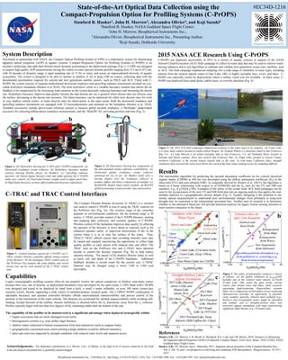
Figure 4. The 2015 ACE field campaigns emphasized variation in the water types to be sampled. (a) Crater Lake
is a clear, deep caldera located in south-central Oregon; (b) Torpedo Wharf is a shoreline wharf in San Francisco
Bay, CA.; (c) Lake Merced is an urban eutrophic lake in San Francisco, CA; (d) Petaluma River, located in
Sonoma and Marin counties, flows into eastern San Francisco Bay; (e) Eagle Lake, located in Lassen County,
northern California. is the second largest natural lake in the state. As with many California lakes, draught
conditions have lowered the water level below the reach of the boat ramp, making access for sampling difficult.
Figure 2. 3D illustration showing key components of
the pole-mounted surface reference constellation. (a)
Downward global irradiance cosine collector
optimized for use in air; (b) Shadow band casts a
moving shadow over the irradiance collector to
produce diffuse and direct components of sunlight; (c)
BioSHADE shadow band control module; (d) BioGPS
global positioning system provides time and position.
c
d
a
b
a b
a b
d
c
e
Figure 5. The utility of end-member analyses is shown
as follows: (a) the global validation of aCDOM(440)
includes one of the clearest water masses on Earth
(Crater Lake, OR), spans the open ocean, coastal
waters, plus inland rivers and lakes, while correctly
separating high-scattering (hypersaline) extreme
lakes; (b) a comparison of absorption versus scattering
characteristics provides an opportunity to partition
water samples optically, wherein more polluted (e.g.,
harbors) and resuspended waters might be identified
and studied; and (c) drought-stricken lakes and
reservoirs appear anomalous with some experiencing
significant algal blooms (e.g., Pyramid Lake).
ba
c
Acknowledgements. The dedicated contributions of J. Brown, Univ. of Miami, to the high level of success achieved in the field
work and analysis presented here is gratefully acknowledged.
References
Hooker, S.B., J.H. Morrow, C.R. Booth, G. Bernhard, R.N. Lind, and J.W. Brown, 2010: Advances in Measuring
the Apparent Optical Properties (AOPs) of Optically Complex Waters, NASA Tech. Memo. 2010-215856, NASA
Goddard Space Flight Center.
Hooker, S.B., J.H. Morrow, and A. Matsuoka, 2013. Apparent optical properties of the Canadian Beaufort Sea –
Part 2: The 1% and 1 cm perspective in deriving and validating AOP data products. Biogeosciences, 10, 4511–
4527.