SlideShare a Scribd company logo
1 of 47
Download to read offline
Check... Set... Dig.Check... Set... Dig.
NOVEMBER - DECEMBER 2006 VOL 2 ISSUE 6
www.gisdevelopment.net
24 DIGGING INFORMATION
SYSTEM
Walid Khalf Sayeed Barakat /
Mohammed Abdul Mannan
28 SOIL THEMATIC GEO
DATABASE FOR DUBAI EMIRATE
Hussein Harahsheh, Mohamed
Elias, AbdulAzim Elniweiri
Mohamed Mashroum,
Yousef Marzouqi, Eman Al Khatib
B.R.M. Rao, M.A. Fyzee
32 POTENTIAL OF USING WEB
SERVICES IN DISTRIBUTED GIS
APPLICATIONS
Pouria Amirian, Ali Mansurian
36 GIS AND INTERNET
GIS TECHNOLOGIES IMPACT
AND CHALLENGES IN LAND
ADMINISTRATION
El-Ayachi Moha
40 OVERLAY ANALYSIS OF GIS
LAYERS TO EVALUATE CHANGES
ON AL SAMMALYAH ISLAND
Salem Essa, Ronald Loughland,
Mohamed E. Khogali,
Abdulmunem Darwish
Cover.qxp 11/9/2006 2:43 PM Page 1
THEME : Geospatial Convergence:The Next Step
9 - 11 April 2007, Dubai World Trade Center, Dubai, UAE
www.mapmiddleeast.org info@mapmiddleeast.org
SEMINARS
GEOSPATIAL EXECUTIVE LEADERSHIP FORUM
OPEN SOURCEOIL & GAS
ISPRS CONFERENCE
CRITICAL INFRASTRUCTURE PROTECTION &
EMERGENCY MANAGEMENT
CONSTRUCTION & ENGINEERING
PHOTOGRAMMETRY REMOTE SENSING
General Enquiry / Information
info@mapmiddleeast.org
Abstracts / Papers
papers@mapmiddleeast.org
Registration
registration@mapmiddleeast.org
Exhibition
exhibition@mapmiddleeast.org
Abstract Submission
15 January 2007
Paper Acceptance
20 January 2007
Full Paper Submission
28 February 2007
Registration
15 March 2007
IMPORTANT DEADLINES
CONTACTS
information from imagery
ORGANISED BY
CO- SPONSOR
The construction activity for urban development has seen a shift from over head and sur-
face based utility lines to underground utility lines. These underground lines contributed
by: telephone, power, cable TV, fibre optics, traffic signals, gas line etc are forming a kind
of spider's web. This web gets further complicated in the scenario where deregulation of
the services is leading to multiple players providing a given service. These utility lines are
often at risk of being damaged unknowingly during the process of excavation or con-
struction either at the same place or in the nearby area. This lead to the urban develop-
ment work, calling for coordination meet amongst the various service provider prior to
any work being undertaken. This was quite evident when the reworking of urban infra-
structure like city highways, telephone cable, power line was initiated.
All this only vindicates the move by the urban bodies to come up with urban SDIs. The
city of Riyadh which has already taken a step in this direction in September 2006, will
'enable public and private agencies to share mapping data and to distribute data changes
and updates in near real-time.' The recent news of EU Satellite Centre [EUSC] with Joint
Research Centre [JRC] providing scientific support to the international donors planning
the distribution of aid in Lebanon through provision of high resolution satellite imageries
is a step in this direction. It is said that the JRC and EUSC would establish an SDI for
detailed assessment of the damages and reconstruction planning. The Web GIS article
'Digging Information System' for the city of Madinah is an initiative on similar lines with
focus on the coordination aspect for on-site construction. The availability of this system
on web increases the usability of this system. The Dubai GIS Center under the Dubai
Municipality [DM] is the one point source for spatial datasets like: base maps, landuse
maps, infrastructure data and operations data. What is impressive the list of government
and private partners which are listed as strategic partner to the DM, which would ulti-
mately contribute to the updation of the spatial data sets maintained by DM. In Feb
2006, a workshop was organized on SDI for UAE, the initiative which soon after was
approved by the Emirates. The Qatar SDI has an excellent system data sharing amongst
the participating agencies, where the agencies can publish their data for sharing. The
data sharing is regulated to be in the framework of national spatial data standards. These
activities are monitored by Center for GIS at Qatar.
The common denominator for all the virtues of urban SDI and the various initiatives tak-
en would be the service to the stakeholders and the coordination amongst them. The
service elements could be influenced by the amount of data which can be accessed
through Web GIS Application. The enterprise solutions offered by leading geospatial ven-
dors would continue to evolve, with a skeptical look by the general public: 'Will Google
Earth or Microsoft Local Live, in future, to provide geospatial tools for utility service man-
agement, a small domain compared to the issues they would like to address?'
7G I S D E V E L O P M E N T - M I D D L E E A S T
Managing Editor
Digging for SDI
maneesh.prasad@GISdevelopment.net
N O V E M B E R - D E C E M B E R 2 0 0 6
Editorial.qxp 11/9/2006 3:36 PM Page 7
8 G I S D E V E L O P M E N T - M I D D L E E A S T
BAHRAIN
Postal Dept. goes
hi-tech
Bahrain joined the interna-
tional community in observ-
ing the World Post Day
(WPD) on October 9th, by fur-
ther expanding its postal
services. Which included
launch of a new GPS naviga-
tion system to monitor its
fleet of 80 vans in streamlin-
ing mail delivery.
Under the new hi-tech sys-
tem, the postal authorities
will be able to track down
each van and check the
assigned route, timings,
speed and distance covered,
said Shaikh Bader.
The new GPS system auto-
matically warns the driver in
case of traffic violations,
locates his position and
checks whether he sticks to
the distribution zone
assigned to him.
The Bahrain Post is com-
mitted to enhancing its serv-
ices to international stan-
dards, said Transportation
Ministry Assistant Under-
Secretary for Posts Shaikh
Bader bin Khalifa Al Khalifa.
The number of post offices in
Bahrain were also increased
to 14 with the opening of a
post office in Juffair last
month, he told the GDN.
"We are now upgrading
the services to make remit-
tance instantly through elec-
tronic channels," said Shaikh
Bader and added that people
would also receive non-pay-
ment notices through the
post offices.
www.gulf-daily-news.com
GIS to be adopted
to manage power
supply
Bahrain is taking steps to
handle an anticipated 65 per
cent surge in electricity con-
sumption over the next six
years.
Major developments such
as Bahrain Financial Harbour
and Durrat Al Bahrain are
expected to drive the mas-
sive increase in demand.
Consumption peaked at
1,840mw this year, said Elec-
tricity and Water Ministry
Under-Secretary Dr Majeed
Al Awadi during a meeting of
the Bahrain French Business
Club (BFBC).
Dr Al Awadi said several
major plans are underway to
help the country cope with
the expected increase in
demand, including the cre-
ation of 15 new substations
and upgrading 10 existing
ones.
Moreover, he also men-
tioned about several major
strategies which are under-
way to help the country cope
with the expected increased
demand .He said, an upgrade
of the customer service sys-
tem, set to be finished next
year, and the introduction of
a GIS by November 2008
would improve the handling
of reported faults.
Dr Al Awadi admitted
upgrading work needed to be
done, but said the ministry
was battling against low rev-
enue margins, old parts of
the network, rapid changes
in consumption patterns and
unauthorised additional
loads.
He said an upgrade of the
customer service system, set
to be finished next year, and
introduction of a GIS by
November 2008 would
improve the handling of
reported faults." The cus-
tomer service system will be
upgraded by the first quarter
of 2007 and these two will
help us a lot and make it eas-
ier to correct problems".
www.gulf-daily-news.com
LEBANON
EU helps in
reconstruction
The European Commission's
Joint Research Centre (JRC),
together with the EU Satellite
Centre (EUSC), is providing
scientific support to interna-
tional donors planning
the distribution of aid in
Lebanon.
High resolution satellite
images have helped the EU
compile a preliminary dam-
age and needs assessment
report for Lebanon. The
report was presented at the
recent donors' conference
held recently in Stockholm.
The images reveal that in
southern Lebanon 1,489
buildings, 535 road sections,
21 of the 29 bridges over
the Litani River and 545 culti-
vated fields were either
destroyed or damaged.
In Beirut 326 residential
buildings have been dam-
aged or destroyed in the
southern suburbs, along
with all the runways of
Beirut airport and six strate-
gic highway sections.
According to the report,
the damage observed to the
roads means access to impor-
tant towns, services such as
hospitals as well as cultivat-
ed fields may be disrupted.
The report also points out
that the satellite images only
show damage to buildings
that is visible from overhead;
in areas where ground bat-
tles took place, considerable
lateral damage to buildings
is also likely.
JRC and EUSC will continue
to support the reconstruction
effort by establishing a spa-
tial data infrastructure to
allow for a more detailed
assessment of the damages.
http://ec.europa.eu/
PAKISTAN
NDMA
constituted
The government has consti-
tuted the National Disaster
Management Authority
(NDMA) to co-ordinate disas-
ter management throughout
the country.
The NDMA has come into
being one year after the dev-
astating earthquake in the
country's north provincethat
killed more than 73,000
people. The authority will be
formalised through a piece of
N O V E M B E R - D E C E M B E R 2 0 0 6
News: Middle East
8-20.qxp 11/9/2006 3:42 PM Page 8
9G I S D E V E L O P M E N T - M I D D L E E A S T
legislation.Speaking at a
function, Prime Minister
Shaukat Aziz said the NDMA
would play its role in any dis-
aster situation. He said the
authority would not only co-
ordinate activities to deal
with consequences of any
disaster but also keep liaison
with the donors.
www.gulf-times.com
Govt to take
Chinese help in
space technology
China and Pakistan will work
together in development of
space technology and
launching of three earth
resources prospecting satel-
lites in the next five years.
The relevant institutions of
the two countries have
already started necessary
spadework to launch the
satellites within stipulated
period.
The two countries have
been playing an active role at
the regional level as well,
strengthening cooperation in
the space industry. Pakistan,
China and seven other coun-
tries signed a treaty for the
establishment of Asia-Pacific
Space Cooperation
Organization (APSCO) last
year, and it would take effect
upon ratification by five
members.
In Asia, China is actively
engaged in the setting up
APSCO, which would be
based in Beijing. Eight coun-
tries, China, Pakistan,
Bangladesh, Indonesia, Iran,
Mongolia, Peru and Thailand
signed the document last
October. Turkey also signed
the convention June this
year, making it the ninth
member of the organization.
The APSCO will be formally
established after China
receives approvals from at
least five participating coun-
tries' parliaments. The for-
mation of the APSCO will
be beneficial to further
exchanges and cooperation
in space technology and its
application and promoting
economic and social develop-
ment, and common prosperi-
ty, in the region, he added.
APSCO will be a platform
to carry out space coopera-
tion to make people benefit
from space technology and
its application. Pakistan and
China played a pioneering
role in establishing the
organization, first of its kind
to expand cooperation in
space activities in the region.
According to the sources,
Pak-China bilateral coopera-
tion in the space industry
could span a broad spectrum
of topics of mutual priority.
www.adnki.com
QATAR
GIS award to Qtel
Qtel, a Qatar based telecom-
munications provider, has
won a 'Special achievement
in GIS' award for the second
time in the last three years,
at the Environmental Sys-
tems Research Institute's
26th Annual User conference
in San Diego, California.
GIS is designed to analyse
and use data related to a geo-
graphical location. For exam-
N O V E M B E R - D E C E M B E R 2 0 0 6
The Dubai Department of Tourism and Commerce Mar-
keting (DTCM) has launched a new interactive Electronic
Map of Dubai on its website.
The site provides the options to view online the Interac-
tive street map along with it the map is also available in
PDF format for those without the Java plug-in on their
computers.
The interactive version of the map offers a convenient
search facility of the major landmarks in the emirate in
addition to a handy directory of hotels, hotel apartments,
shopping malls, hospitals, diplomatic missions, heritage
sites, places of interest, and upcoming mega projects
among a host of important points of interest. Areas of
interest can be expanded for greater details and printed
for hard-copy use.
The DTCM Manager Information Technology, Mr.
Suhail Buhelaiba, said: "The new facility provides a virtu-
al tour of Dubai. It enhances the appeal of the DTCM web-
site in the online community. This will come handy to
millions of Dubai visitors as well as the residents. The
usage of this map will be immense to everyone, especial-
ly businesses and tourists."
The map has been exclusively designed for the DTCM
with the software provided by Belhane, a German Cartog-
raphy company. The department has partnered with Easy
Map Advertising which will be responsible for marketing
the advertising space on the map. The company will also
enable a business in Dubai to locate them on the map and
provide power-links.
www.dubaicityguide.com
Interactive e-map
8-20.qxp 11/9/2006 3:42 PM Page 9
10 G I S D E V E L O P M E N T - M I D D L E E A S T
ple, in the telecommunica-
tions industry, GIS helps Qtel
determine a customer's resi-
dent location, nearest pay
phone or cable network, or
the best location to set up a
new customer service center.
Qtel was selected from
over 100,000 GIS users
worldwide for the award,
which recognises Qtel's effec-
tive use of GIS to manage its
advanced telecommunica-
tions network.
Qtel has fast developed GIS
technology to help in track-
ing the location and charac-
teristics of their outside
infrastructure and improv-
ing access to information
when engineering new proj-
ects. The company has made
rapid strides to improve cus-
tomer satisfaction through
GIS by providing useful
applications for managing
different aspects of Qtel
services in residential wire-
line, GSM networks, inter-
exchange transmissions,
Triple Play, ADSL coverage
and pay phone planning and
management.
The company has also
developed a Telecommunica-
tion Access Network Man-
agement System (TEAMS
9.4), which successfully con-
verted massive amounts of
data and drawings and over
50,000 documents into a dig-
ital format.
The 'TEAMS 9.4' applica-
tion is designed to manage
the Qtel inside and outside
plant and to automate the
entire workflow making it
faster and more efficient to
access geographical data
linked to the construction of
roads, setting up network
cables and other under-
ground work, etc and for pro-
cessing building permit
applications.
www.qtel.com.qa
SAUDI ARABIA
Satellite
Navigation
system to control
air traffic
Saudi Arabia is planning to
change its civil aviation nav-
igation system from ground
based to satellite based in
phases.
According to Muhammad
Al-Salimi, Director of air cor-
ridors at General Authority
for Civil Aviation (GACA), the
new system will be imple-
mented partially at this
stage, as the total shifting to
the new international navi-
gation system requires time
and should pass through dif-
ferent phases.
Al-Salimi said the King-
dom would enter into serious
negotiations with a number
of countries under the
umbrella of the International
Civil Aviation Authority to
set out laws on the use of
satellites for air navigation.
He said the Kingdom
would participate in the
activities of the International
Civil Aviation Organization
to develop and modernize
civil aviation systems, set
out new regulations, and
modernize the management
of air traffic. Al-Salimi
made this statement while
addressing a meeting of the
working group to implement
future navigation systems.
The meeting was organized
by the GACA.
The shift from ground-
based system to satellite-
based requires qualified
manpower. The GACA will
conduct intensive training
courses for its air traffic con-
trol staff in satellite and digi-
tal communication.He said
the authority was currently
applying satellite communi-
cation in some airlines. The
objective is to help airlines
save time by reducing flight
duration. This will also
increase air traffic and
attract foreign airline com-
panies, he explained.
Opening the meeting,
GACA President Abdullah Al-
Rehaimy said he was looking
forward to setting out mech-
anisms that help Arab civil
aviation administrations and
airline companies to set up
air corridors to provide air-
link to aircraft equipped with
FANS1A satellite air naviga-
tion systems in Arab skies.
"Arab countries will bene-
fit a lot by applying this
modern air navigation sys-
tem in terms of economic
and operational aspects and
the benefit will reflect direct-
ly on air navigation service
providers as well as airlines
and other users," Al-Rehaimy
said.
Spelling out the benefits,
he said direct use of air corri-
dors would help save fuel,
reduce the time for flight,
increase air corridor capacity,
help open new air corridors
and thus help increase air
traffic and financial returns
of Arab aviation authori-
ties."It will also reduce the
work of aviation control
staff; achieve more efficiency
in communication between
air control staff and pilot as
they will use digital data
instead of sound data. This
will also lead to improving
aviation security and safety,"
he added.
Al-Salimi said the meeting
was aimed at promoting
coordination between air
control offices in Arab coun-
tries in preparation to apply
the new satellite system. He
said total reliance on the
satellite air navigation
system would be achieved by
2015.
www.arabnews.com
Galdos to develop
Riyadh's SDI
Galdos Systems announced
recently that it had been con-
tracted to develop an urban
spatial data infrastructure
(SDI) within the city of
Riyadh, Saudi Arabia.
The urban SDI will enable
public and private agencies
to share mapping data and to
distribute data changes and
updates in near real-time.
The objective of this project
is to enable users of the
N O V E M B E R - D E C E M B E R 2 0 0 6
8-20.qxp 11/9/2006 3:42 PM Page 10
11G I S D E V E L O P M E N T - M I D D L E E A S T
system to significantly
reduce data redundancy cost
and increase productivity
through access to timely
data."The city of Riyadh is
truly an innovator in urban
management," said Ron Lake,
Chairman & CEO of Galdos
Systems Inc. "By developing
an urban SDI, public and pri-
vate agencies can collect and
share real-time data while
dramatically decreasing con-
cerns of data redundancy
and accuracy."
The urban SDI will enable
agencies like, Riyadh Water
& Sewage, Arriyadh Develop-
ment Authority, and Saudi
Telecom to share only data in
real time that is of interest to
specific participants to
enhance their decision-mak-
ing processes.
Participants cannot modi-
fy data that does not belong
to them. The data does not
emerge from a centralized
warehouse; rather it is a dis-
tributed system, utilizing the
latest collected data of each
participating organization.
www.galdosinc.com
TURKEY
u-blox expands its
presence
u-blox AG, a provider of GPS
receiver technology announ-
ced recently that it has
expanded its distribution
network into new growth
market by signing agree-
ment with electronics dis-
tributor Kayra Elektronik of
Turkey.
Kayra Elektronik distrib-
utes GPS and GSM-related
products such as antennas,
connectors, LCD displays and
cables. The company focuses
on distributing mobile com-
munications and positioning
industries products.
" u-blox' innovative posi-
tioning solutions will benefit
both the GPS and GSM mar-
kets immensely, both of
which constitute prime tar-
get markets here at Kayra"
said Fatih Coksak, Product
Manager at Kayra Elektronik.
www.theautochannel.com
UAE
ANTRIX to
distribute
CARTOSAT-1
imagery
Global Scan Technologies
(GST), a Dubai-based compa-
ny providing Remote Sensing
and GIS technologies in
the Middle East, recently
announced that it had signed
a contract with India's
ANTRIX Corporation Limited,
a provider of satellite images
worldwide and the market-
ing arm of the Indian Space
Research Organization (ISRO)
under the Department of
Space, Government of India.
GST's agreement with
ANTRIX includes distribution
of Cartosat-1 imagery with
2.5m resolution in both
pan and stereo modes.
The unique high-resolution
along-track stereo imaging
capability of Cartosat-1, car-
ried out for the first time
anywhere in the world,
enables generation of Digital
Elevation Models (DEM) and
other value-added products.
The data from Cartosat-1 is
expected to provide
enhanced inputs for large
scale mapping applications
and stimulate newer applica-
tions in the urban and rural
development, land and
water resources manage-
ment, disaster assessment,
relief planning and manage-
ment, environment impact
assessment and various oth-
er Geographical Information
System applications. The
data can be used for genera-
tion and updating of large-
scale topographic maps.
"Our agreement with
ANTRIX allows us to distrib-
ute Indian Satellite imagery
in the UAE and many other
Middle East countries", said
Dr.Hussein Harahsheh of
GST.
www.ameinfo.com
Dubai
Municipality rolls
out EPIMS
Dubai Municipality's IT
department has launched
the first phase of the
Engineering Projects Infor-
mation Management System
(EPIMS) within the organisa-
tion.
The system enables all the
staff and clients to communi-
cate through an integrated
electronic channel, resulting
in significant time savings
and error-free completion of
transactions. It also facili-
tates easy access to informa-
tion, leading to better deci-
sion making.
Hussain Lootah, Director
General of Dubai Municipali-
ty, said, "We are continuous-
ly committed to adopting
the latest in information
technology to enhance our
customer services. “The new
project allows various
departments in the munici-
pality such as Contracts &
Purchasing, General Projects,
and Finance, to submit their
applications electronically.
These applications range
from accreditation materials,
graphics, plans, programmes
and reports about the imple-
mentation of the engineer-
ing projects, in addition to
financial requirements.
EPIMS facilitates more
effective internal communi-
cation between all depart-
ments of Dubai Municipality.
The departments that will
benefit from the implemen-
tation of this system include
Contracts & Purchasing, Gen-
eral Projects, Finance, Histor-
ical Buildings and Coastal
N O V E M B E R - D E C E M B E R 2 0 0 6
8-20.qxp 11/9/2006 3:42 PM Page 11
12
Management, in addition to
some of the external users.
Further, it provides direct,
detailed and accurate infor-
mation for contractors and
consultants," Lootah added.
The first phase of the
EPIMS began in August 2006
and Dubai Municipality's IT
department is now working
on implementing the second
phase of the system to cater
to the requirements of other
engineering departments in
the municipality.
www.cpilive.net
Dubai Land
Department
implements DMS
Dubai Land Department has
digitizes all the documents
by implementing a docu-
ment management solution
from FileNet, a provider of
Enterprise Content and Busi-
ness Process Management
solutions.
This will speed up land and
property transactions in
Dubai. This system helped
Dubai Land Department
overcome several challenges,
including fragmentation of
information as a result of
data being scattered in vari-
ous systems and forms, slow
customer transaction pro-
cessing time, and the need to
meet increasing regulations.
With 1.5 million pages rep-
resenting the backlog of
paper documentation
already migrated to a FileNet
system and an additional 3.5
million pages set to be added
from the on going New
Dubai real-estate project.
'With more than 54,000
plots registered in Dubai, it
was becoming increasingly
unsustainable to manage the
associated paperwork and
documents. Accessing impor-
tant documentation was
proving to be a time-con-
suming process for internal
and external users alike,
which persuaded us to digi-
talise all documents of the
department,' said Khalifa
Ahmed Al Zuraim, Head of IT
Centre, Dubai Land Depart-
ment. 'We conducted a com-
prehensive technical evalua-
tion of solutions from 10
companies, and found that
FileNet's advanced Docu-
ment and Content Manage-
ment solution was easily the
most reliable and flexible.'
'FileNet is pleased to asso-
ciate with Dubai Land
Department for this land-
mark project,' said Alessio
Gallo, International Sales
Director, South Europe, Mid-
dle East and Africa, FileNet.
FileNet applications are
integrated with Oracle busi-
ness applications, the depart-
ment's internal GIS system,
and Dubai Municipality's GIS
system enabling access to
land documents. The imple-
mentation was carried out
by Gulf Computers, a FileNet
Partner in the Middle East.
www.ameinfo.com
GPS Industries Inc
signs MOU for
investment
GPS Industries, Inc., the inno-
vator of Wi-Fi enabled GPS
systems for golf courses and
residential communities,
announced on recently that
it has signed a Memorandum
of Understanding (MOU)
with an affiliate of a large
investment group located in
the UAE for a US$10M private
placement for the Company's
preferred stock.
Management believes that
the investment from the
Dubai group will lead to
additional investments from
other investors.
http://press.xtvworld.com
YEMEN
Managing water
resources
As many water basins in
Yemen are facing water
shortages due to changing
climatic conditions and over-
use of ground waters, a need
to develop and properly
manage available water
resources is being felt.
Considerable investments
are allocated for constructing
and rehabilitating water
storage structures, to
enhance ground water dis-
charge, for expand irrigated
areas, and providing water
for other uses.
To understand the effect of
dams on water status in giv-
en water basin, various inves-
tigations are required for
determining surface water
and groundwater hydrology,
and subsequently advising
proper water resource man-
agement strategies.
In a study of Sawan water-
shed, which is located in
Sana'a basin, the effect of
three small dams on shallow
groundwater discharge was
observed. To study the effect
of dams on groundwater dis-
charge, static water levels in
a number of open wells was
observed in 2000 and 2001.
Static water level (SWL) of
wells near Mukhtan, Konaz-
er, Beryan dams were signifi-
cantly affected by the dis-
tance from the dams. The
SWL of wells closer to
Mukhtan dam was 9 m while
SWL of well at distances of
about 5.7 Km from the dam
was 22.6 m. In the case of
Beryan dam, SWL were 7.9 m
and 11.7m for wells at dis-
tances 0.3 km and 6.1 km
from the dam, respectively,
while SWL was found at 9 m
in wells near Konazer dam
and 22.3m in wells at 4.5 Km
from the dam. This indicates
the presence of groundwater
discharge, especially in the
areas near the dams.
This study recommends
documenting hydroclimatic
data in order to establish an
information database for
major watersheds, and to
carry out comprehensive
studies and investigations on
the effects of dams. An
emphasis is required to uti-
lize mathematical models,
GIS and other programs in
the Rapid Risk Assessment
program of watershed and
dams.
http://yementimes.com
N O V E M B E R - D E C E M B E R 2 0 0 6G I S D E V E L O P M E N T - M I D D L E E A S T
8-20.qxp 11/9/2006 3:42 PM Page 12
ROLTA
● ● ● ● ● ●USA:1-678-9425000 Canada:905 - 361 - 2878 Benelux:31 - 23 - 5571916 Germany:49 - 6102 - 299985 UK:44 - 1189 - 450011 Dubai:971 - 4 - 3915212 SaudiArabia:966 - 1 - 2421212
Certification
Q M S
C E R T I F I E D
ISO 9001 : 2000
GLOBAL PHOTOGRAMMETRY, GIS AND UTILITIES & COMMUNICATION SERVICES
14
BUSINESS
Leica Geosystems
receives Frost &
Sullivan Market
Leadership Award
Frost & Sullivan, a New York-
based consultancy firm, con-
ferred London Market Lead-
ership Award in the Laser
Tracker Segment on Leica
Geosystems in London
recently.
Already the recipient of the
2004 Frost & Sullivan "Indus-
trial Automation Product
Innovation of the Year"
award for its Portable CMM
line of products, Leica
Geosystems was selected in
2006 for its sales growth and
its stress on emerging tech-
nologies.
www.leica-geosystems.com
Rolta gets ISO/IEC
20000-1:2005
ITSM certification
India based Rolta is the 21st
company in the world certi-
fied by BSI with "ISO/IEC
20000-1:2005 IT Service Man-
agement standard". BSI, the
largest and most respected
management systems regis-
trar in the world is supported
by BSI Group offices, con-
ducted the assessment for
the certification.
Rolta had been certified for
BS 15000 for its IT Service
Management operations.
This new certification is an
upgrade of BS 15000 stan-
dard, and describes an inte-
grated set of management
processes for
effective delivery of services.
ISO 20000 is aligned with
and complementary to the
process approach defined
within the IT Infrastructure
Library (ITIL) from The Office
of Government Commerce
(OGC), UK.
Vinay Sawarkar, Sr. Execu-
tive Director - Rolta, speaking
on the occasion of certifica-
tion said, "ISO 20000 is
increasingly seen as the
quality standard for IT Ser-
vice Management and many
companies are striving to
adopt ISO 20000, not only for
their own benefit, but also to
help qualify and choose sup-
pliers and partner organiza-
tions.
This certification reaffirms
Rolta's endeavor to adhere to
the Best IT Service Manage-
ment Practices in the world,
for its customers, partners
and stakeholders".
www.rolta.com
OSI Geospatial
gets contract from
US Dept. of
Defense
OSI Geospatial Inc. recently
announced on September 27
that its U.S. systems opera-
tions had been awarded a
three-year contract totaling
approximately US$3.8 mil-
lion by the US Defense Threat
Reduction Agency (DTRA).
Under the contract terms, OSI
will develop a GPS Denied
Navigation and Mapping
System for the DTRA.
"OSI is into development
and production of Naviga-
tion and Mapping systems
for international military
and commercial applica-
tions. This contract will
enable OSI to evolve our lead-
ing edge technology into the
Hand-Held/Wearable Per-
sonal Navigation Systems
market," said Ken Kirk-
patrick, President and CEO of
OSI Geospatial.
www.osil.com
ISRO gets contract
to launch 16 nano
satellites
Around September 2007,
India's rocket Polar Satellite
Launch Vehicle (PSLV) will
carry a 100 kg capsule as an
additional passenger into
space. The capsule will
unfurl a series of 16 nano
satellites that weigh
between one kg and five kg.
The University of Toronto,
Canada, leads a team of aca-
demic institutions that
would build these satellites,
designed to conduct research
on outer space, including
micro-gravity experiments.
It has contracted out the
launch to the Indian Space
Research Organisation
(ISRO). Nano satellites weigh
less than 10 kg and multiple
satellites work together as a
network in space. In some
cases, these formations of
nano satellites are connected
to a bigger satellite, called
the mother, for communica-
tion purposes.
The PSLV rocket has piggy-
backed micro satellites that
weigh up to 100 kg to space,
but this would be India's first
experience in launching
nano satellites. "We have
several small satellites from
universities in India and
abroad that will be launched
over the next few years," an
official said.
ISRO will loft a 50 kg
Indonesian remote sensing
satellite with Cartosat-2, the
home-grown one-metre reso-
lution remote sensing satel-
lite, when the PSLV is
launched next month. In the
past, India's rockets have car-
ried several micro satellites
weighing less than 60 kg,
including the Korean KIT-
SAT-3, German DLR-TUBSAT,
BIRD of Germany and PROBA
of Belgium, into their intend-
ed orbits.
www.dnaindia.com
Hirayama to head
TPS-Australia
Tony Hirayama, Topcon Posi-
tioning Systems' (TPS) Execu-
tive Vice President, has
assumed the role of President
and CEO of TPS-Australia.
He will also have the title of
President and CEO with KEE
Technologies, which joined
TPS on October 3 this year.
Les Mann, former KEE Presi-
dent and CEO, will be the
new Chief Operating Officer
at KEE.
The announcement was
made by Ray O'Connor, TPS
President and CEO, who will
be Chairman of the TPSA
board.
www.topconpositioning.com
N O V E M B E R - D E C E M B E R 2 0 0 6G I S D E V E L O P M E N T - M I D D L E E A S T
News: World
8-20.qxp 11/9/2006 3:42 PM Page 14
15G I S D E V E L O P M E N T - M I D D L E E A S T
ESRI President
awarded Henry
Shaw Medal
ESRI President Jack Danger-
mond was awarded the Hen-
ry Shaw Medal in a ceremo-
ny on September 13, 2006, at
the Missouri Botanical
Garden in St. Louis, Missouri.
ESRI's ArcInfo and ArcView
software allow the garden to
integrate its vast resources of
expert knowledge and
herbarium data with climate,
soil, and elevation data to
analyze plant geographic
ranges and patterns of
diversity.
Using ESRI's ArcIMS tech-
nology, the garden created a
Web interface for sharing its
plant data with the world.
Not only does this allow it to
provide global mapping
capabilities for all the speci-
mens in its database, but it
can also customize interac-
tive maps with various envi-
ronmental data layers,
giving the garden's col-
leagues invaluable resources
for prioritizing their collec-
tion strategies.
Presented since 1883, the
medal recognizes those who
have made significant contri-
butions to the Missouri
Botanical Garden, botanical
research, or conservation. It
is named in honor of Henry
Shaw, a successful St. Louis
businessman who founded
the Missouri Botanical Gar-
den in 1859.
www.esri.com
Tele Atlas
expands
operations
Tele Atlas officially inaugu-
rated Tele Atlas Polska, the
company's East European
headquarters, with office
openings in Warsaw and
Lodz on September 20.
Tele Atlas Polska's opera-
tions were initially formed
through Tele Atlas' acquisi-
tion of Warsaw-based PPWK
GeoInvent in October 2005.
PPWK GeoInvent developed
a mobile mapping system,
which speeds the data cap-
ture and map update process
and helps Tele Atlas quickly
deliver high quality maps
that incorporate data,
images and other valuable
local content to customers
and partners around the
world.
Tele Atlas Polska is respon-
sible for developing mobile
mapping and image process-
ing technology. The compa-
ny's worldwide Mobile Map-
ping and Image Technology
Centre in Lodz manages the
research and development of
mobile mapping technology,
the production of mobile
mapping units and oversees
image processing. The War-
saw office is responsible for
database operations in
Poland and the Baltic states,
serving as the development
platform for Central and
Eastern Europe. Tele Atlas
Polska currently has more
than 150 employees and con-
tract operators and plans to
expand its operations with
employees specialised in
information technology
and GIS.
www.teleatlas.com
Trimble reports
3rd Q '06 growth
of 25 %
Trimble has announced the
results for its third quarter
2006, ended September 29,
2006. Revenue for the third
quarter of 2006 was $234.9
million, up 25 percent from
revenue of $188.5 million in
the third quarter of 2005.
Operating income for the
third quarter of 2006 was
$36.3 million, up 10 percent
from the third quarter of
2005. Net income for the
third quarter of 2006 was
$25.3 million, up 25 percent
when compared to net
income of $20.2 million in the
third quarter of 2005.
Earnings per share for the
third quarter of 2006 were
$0.43, up approximately 23
percent compared to earn-
ings per share of $0.35 in the
third quarter of 2005. Earn-
ings per share in the third
quarter of 2006 were nega-
tively impacted by approxi-
mately $0.03 due to the
adoption of FAS 123R and by
approximately $0.03 due to
higher amortization of intan-
gibles.
http://trmb.client.shareholder.com
Intergraph
takeover gets
antitrust
clearance
Intergraph Corporation, a
provider of spatial informa-
tion management (SIM) soft-
ware, announced recently
that the US antitrust agen-
cies had granted early termi-
nation of the waiting period
under the Hart-Scott-Rodino
Antitrust Improvements Act
of 1976, as amended, effec-
tive September 26, 2006, in
connection with the Compa-
ny's pending acquisition by a
private investor group led by
Hellman & Friedman LLC and
Texas Pacific Group in a
transaction valued at
approximately $1.3 billion.
Intergraph had announced
on August 31 that it has
signed a definitive agree-
ment to be acquired by the
investor group. Intergraph's
Board of Directors had
approved the merger agree-
ment and had resolved to
recommend that Inter-
graph's stockholders adopt
the agreement.
The transaction remains
subject to the receipt of
shareholder approval as well
as the satisfaction of other
previously disclosed closing
conditions. The transaction is
expected to close in the
fourth quarter of 2006.
Terms of the transaction
call for stockholders to
receive $44 cash per share. If
approved, the move will
make private one of
Huntsville's longtime pub-
licly traded companies.
www.intergraph.com
N O V E M B E R - D E C E M B E R 2 0 0 6
8-20.qxp 11/9/2006 3:42 PM Page 15
N O V E M B E R - D E C E M B E R 2 0 0 616 G I S D E V E L O P M E N T - M I D D L E E A S T
eSpatial and
TerraNor to
deliver iSMART
products
eSpatial, a geospatial soft-
ware and technology compa-
ny and TerraNor, a company
providing software for GIS,
remote sensing and digital
mapping, signed a Reseller
Agreement.
Under the agreement Terra-
Nor will act as a reseller
for iSMART5, in the Nordic
countries (Denmark, Finland,
Iceland, Norway, Sweden,
Greenland). eSpatial's
iSMART product supports a
number of deployment mod-
els, which include Pure Web
and Customized Client with-
in a scalable, role-based and
secure environment.
The architectural features
delivered with iSMART
address standard IT require-
ments for the deployment of
enterprise business applica-
tions.
iSMART provides an ideal
enterprise grade hosted serv-
ices delivery platform for
geospatial applications.
Delivered applications and
services can also be provided
to conform with the Open
Geo Spatial Consortium
(OGC) Web Services stan-
dards.
www.espatial.com
3001 Inc. to
acquire LandAir
3001, Inc., announced recent-
ly that after working togeth-
er for many years, including
an eighteen month period
where LandAir Mapping, Inc.
(LandAir) acted as the fourth
business unit of 3001 provid-
ing all flight operations and
related services, 3001 has
finalized the agreement to
wholly acquire LandAir.
LandAir, a small geospatial
business successfully run by
President Tom Olive since
1988, is a contract holder
under US Department of
Agriculture's National Agri-
cultural Information Pro-
gram (NAIP) and as such, was
awarded the largest number
of states for high-resolution
aerial photo acquisition.
LandAir also successfully
managed dozens of other
projects in the last years, elic-
iting praise from clients all
around.
LandAir teaming with 3001
began in 2003, when the two
firms joined forces to support
the U.S. Army Corps of
Engineers in the acquisition
and processing of natural col-
or imagery at 1 meter resolu-
tion imagery for the entire
island of Puerto Rico. The two
companies' production staff
and management developed
trust in a shared vision
for high quality imagery
products.
Mr. Olive will stay on to
run 3001's LandAir Mapping
business unit. "I am looking
forward to a little extra time
that this acquisition affords
me to consider future sensor
investments. The economies
we enjoy by joining forces
will allow us to spend more
time listening and learning
of new ways to save time
and money for our clients",
says Tom Olive.
www.3001inc.com
Global study
shows benefits of
location
intelligence
According to a survey con-
ducted by MapInfo Corpora-
tion, a provider of location
intelligence solutions, and
BusinessWeek Research
Services, 64 percent of
business executives believe
that location intelligence can
improve business processes,
and 21 percent are planning
to investigate it in the
next year.
1,700 business executives
participated in this interna-
tional study to gauge the role
that technology can play in
delivering powerful, busi-
ness-relevant location intelli-
gence to leading organiza-
tions.
80 percent of data that an
organization uses to make
key decisions to improve its
efficiency, effectiveness and
profitability has a location-
based component.
Optimizing information
such as a ZIP code, telephone
number or address enables
companies to answer critical
questions such as: Where can
I find more of my best cus-
tomers? Where are competi-
tors impacting my business?
Where is my newest product
or service most valuable?
For instance, MasterCard
Worldwide relies on the
MapInfo Envinsa location
intelligence platform to pow-
er its worldwide ATM Locator
service. Envinsa replaced
MasterCard's previous online
and phone ATM Locator serv-
ices with a more integrated
platform for deploying loca-
tion technology across the
entire organization. As a
result, MasterCard was able
to reduce costs and provide
enhanced customer service
to millions of customers.
www.mapinfo.com
Trimble acquires
Visual Statement
Trimble announced recently
that they had acquired pri-
vately-held Visual Statement
Inc. of Kamloops, British
Columbia, Canada in an all-
cash transaction.
Visual Statement provides
state-of-the-art desktop soft-
ware tools for crime and col-
lision incident investigation,
analysis and reconstruction,
as well as statewide enter-
prise solutions for reporting
and analysis used by public
safety agencies.
The company is an addi-
tional investment in the
Mobile Solutions business
segment that supports Trim-
ble's strategy of providing
productivity solutions for
mobile workers.
Financial terms were not
disclosed. The Visual State-
ment acquisition comple-
ments Trimble's subsidiary,
Advanced Public Safety
(APS).
www.trimble.com
8-20.qxp 11/9/2006 3:42 PM Page 16
N O V E M B E R - D E C E M B E R 2 0 0 6 17G I S D E V E L O P M E N T - M I D D L E E A S T
APPLICATION
Satellite pics help
claiming higher
compensation
Roughly 140 kilometre from
Mumbai, the capital city of
Indian state of Maharashtra,
farmers are turning to tech-
nology to fight for their
rights.
Four months ago, the farm-
ers of Pen taluka in Raigad
district were told the state
government was acquiring
their land to help build the
25,000 acre Maha Mumbai
Special Economic Zone (SEZ).
That's when an activist of
the SEZ Hatao Virodh Samiti,
Arun Shivkar, logged on to
Google Earth. "We used
Google technology to prove
to the authorities that the
land is fertile," said Shivkar.
Shivkar says initially state
authorities claimed that only
a small portion of the ear-
marked land is fertile and
that some parts of it is sub-
merged by salty creek water,
meaning lower compensa-
tion for the farmers.
But Google Earth has come
to the rescue and its satellite
pictures clearly indicate crop
areas. This has helped farm-
ers back their claims for high-
er compensation. The tech-
nology has also brought
together farmers from 45 vil-
lages to put up a common
front and protest the acquisi-
tion of their land.
The ingenious ways in
which farmers in Maharash-
tra are using Google Earth to
fight for their rights is per-
haps a testament to how
technology is truly flattening
the world.
www.ibnlive.com
Satellite
imageries reveal,
green means rain
Scientists from Natural Envi-
ronment Research Council
(NERC)-funded Climate and
Land Surface Interactions
Centre (CLASSIC) have found
that the presence of green
vegetation has a major influ-
ence on the amount of rain
that falls in the Sahel region
of Africa, south of the Sahara
desert.
Rains at the start of the
growing season cause vege-
tation growth. This encour-
ages a feedback loop as
the greener the vegetation
becomes, the greater the
amount of rain that falls.
This important new
research could help us to pre-
dict future droughts in
Africa. The research can be
used to aid regional and
international forecasts for
rain-starved regions.
Using satellite technology,
Dr Sietse Los and colleagues
at CLASSIC worked with
NASA to develop a dataset
covering 18 years of vegeta-
tion greenness records. They
combined these records with
rainfall data in the region
over the same period -- from
1982 to1999.
The resulting analyses
show, for the first time, that
rainfall amounts vary
between 10% and 30% more
when the land is green, and
decreases by a similar
amount when conditions are
dry and there is little green
vegetation growing. The
research was published in
Geophysical Research Letters
(USA), August 2006.
www.nerc.ac.uk
New crop
insurance tools
made available
The US Department of Agri-
culture has made available
two new risk management
tools for pasture, rangeland
and forage in a select group
of states for a pilot program,
beginning with the 2007
crop year.
The rainfall index insur-
ance program and the vege-
tation index insurance pro-
gram, offered by USDA's Risk
Management Agency, will
allow livestock producers to
purchase insurance protec-
tion for losses of forage.
"These new insurances
tools will help farmers and
ranchers, especially with
operations located in
drought-impacted areas, to
improve their risk manage-
ment capabilities," said U.S.
Agriculture Secretary Mike
Johanns.
The rainfall index program
will be tested in 220 counties
in Colorado, Idaho, Pennsyl-
vania, South Carolina, North
Dakota and Texas. The vege-
tation index insurance pro-
gram will be tested in 110
counties. And is based on
satellite imagery as a means
to measure expected produc-
tion losses.
www.vafb.com
Website shows
damage inflicted
areas
If a picture is worth a thou-
sand words, digital satellite
imagery could inspire tomes'
worth of new environmental
policies. At least that's the
hope of the designers behind
the 'Atlas of Our Changing
Environment'
A unique new Web site that
uses a digital map frame-
work to catalog damage
inflicted on the Earth
over the last few decades,
(http://na.unep.net/digital_a
tlas2/google.php).
"It is as simple as seeing is
believing," said Patrick
Joseph, an environmental
journalist who writes a blog
for the nonprofit Sierra Club.
"You can read a million times
over that the Amazon is
being deforested, but satel-
lite imagery really helps give
you an idea of the scale on
which it is happening."
The atlas's visual evidence
of destruction is already
helping some environmental
8-20.qxp 11/9/2006 3:42 PM Page 17
N O V E M B E R - D E C E M B E R 2 0 0 618 G I S D E V E L O P M E N T - M I D D L E E A S T
groups get the word out
about their issues. Sierra
Club, for instance, has used
images from the atlas in its
member magazine, Sierra.
The new site is based on
Google Earth. The U.S. branch
of the United Nations Envi-
ronment Programme (UNEP)
partnered with Google to cre-
ate a "layer" of data that
users can navigate using
Google Earth or view in a
Web browser.
news.nationalgeographic.com
NASA probes
origin of
hurricanes
The NASA- backed mission
has set up three radars one in
landlocked Niger's capital
Niamey, the one in Kawsara
on the Senegalese coast, and
one on the Cape Verde
Islands and is also flying
planes into the centre of the
depressions. The objective is
to understand how hurri-
canes that slam into the
southeastern United States
and the Caribbean are
formed in West Africa before
they go bowling across the
Atlantic.
The data provided by these
radars will enable scientists
for the first time to map
more fully the atmospheric
conditions as Atlantic hurri-
canes are born and through
their life cycle. Previous
attempts to understand the
phenomenon have relied on
satellite data, which can
show what is happening on
top of clouds but not inside
them.
The study could help
forecasters better predict
devastating hurricanes like
Katrina.
"This is the first time with
aircraft, with radars on the
ground, that we can look
inside these disturbances.
And once you understand
what's happening inside you
have a better chance of pre-
dicting," said Greg Jenkins, a
specialist in tropical meteor-
ology from Howard Universi-
ty, Washington.
Paul Kucera from the Uni-
versity of North Dakota, who
has studied weather patterns
in Papua New Guinea, the
South China Sea and around
the Amazon, said, "If we can
capture the atmospheric con-
ditions of the storm, the
storm structure, how they
evolve over the African conti-
nent and just off the coast,
our objective is to distinguish
between those that stay
together and those that dissi-
pate."
http://timesofindia.indiatimes.com
Satellites to
monitor land use
in Beijing
Beijing will use three satel-
lites to monitor land use as
part of a crackdown on illegal
real estate development
activities, a local land official
has said.
Starting November, Beijing
will investigate and prose-
cute major cases of illegal use
of land, especially those that
violate government plans or
national industrial policies
and those that infringe on
farmers' legitimate rights as
told by An Jiasheng, Director
of the Beijing Municipal
Bureau of Land and
Resources.
Authorities can now avail
themselves of satellite
remote sensing technologies
to discover and prevent the
illegal use of land, An told a
conference.
The Chinese central gov-
ernment tightened control
over land after the economy
grew 10.9 percent in the first
half, promising to penalize
local officials who fail to stop
or investigate land use trans-
gressions.
The Ministry of Land and
Resources laid down in a
recent circular that local gov-
ernments must not approve
more land for construction in
2007 than they did in 2006.
"The principle is to
strengthen macro-economic
control and use land
resources economically," it
said, adding that localities
must make use of land "sci-
entifically and rationally"
to protect farm land and
land for other agricultural
purposes.
It urged localities to "act
conjointly" with the State
Council in implementing
macro-economic control poli-
cies and prevent runaway
fixed-asset investment.
www.chinadaily.com.cn
CRISP detects hot
spots in wildlife
reserve
Singapore`s Satellite Centre
for Remote Imaging Sensing
and Processing (CRISP) on
September 6 detected six hot
spots in a wildlife reserve in
Kendawangan, Ketapang
District, West Kalimantan
Province.The Singaporean
CRISP also detected some a
hot spot at a national park in
Aur Kuning, Ketapang Dis-
trict, in the province, accord-
ing to information from the
West Kalimantan forestry
service`s forest fire control
unit here on Thursday.
There were a total 58 hot
spots in West Kalimantan,
and 42 of them were in Keta-
pang District.
Some six hot spots in
Bengkayang District, five hot
spots in Pontianak District
and another five hot spots in
Sanggau district.
Head of the West Kaliman-
tan Natural Resource Conser-
vation Agency (BKSDA)
Awen Supranata said that
cloud seeding would contin-
ue be conducted to trigger
rain in the forest fire areas.
Awen Supranata said the
cloud seeding process has
been carried out from Sep-
tember 1-7, 2006, to put out
forest fires among other
things in Bengkayang, Sin-
tang, Pontianak, Pontianak
and Ketapang.
"About 20 tons of artificial
salt are dropped every day to
trigger cloud seeding. The
success rate is around 80 per-
cent," he said.
www.antara.co.id
8-20.qxp 11/9/2006 3:42 PM Page 18
N O V E M B E R - D E C E M B E R 2 0 0 6 19G I S D E V E L O P M E N T - M I D D L E E A S T
PRODUCT
Telogis launches
OnTrack4
Telogis, a provider of on
demand web-based GPS
tracking systems, has
released the advanced ver-
sion of OnTrack, its fleet
tracking, productivity, and
management solution, now
integrated with GeoStream
mapping technology.
Added key features of
OnTrack4 include: NAVTEQ
ultra fast premium maps
with free quarterly updates;
"SEARCH!" Instantly find
vehicles, drivers, and key
locations; Unlimited user
defined map sizing for wall
mounted dispatch monitors;
and user defined reports
with automated alerts and
reporting tools.
www.telogis.com
MapInfo releases
MapMarker Plus
v12.0
MapInfo Corporation intro-
duced on August 24 Map-
Marker Plus v12.0, a geocod-
ing tool. MapMarker Plus
v12.0 outperforms current
geocoding technology,
adding a new patent-pend-
ing algorithm that more pre-
cisely identifies locations.
MapMarker Plus v12.0
delivers data-building tools
and interpolation method-
ologies that bring companies
as close as 75 feet on average
to a given address, closer to
its actual location on the
ground. In addition, this ver-
sion includes the optional
MapMarker ParcelPrecision
data set, the ground-level
data available containing
forty-four million address
points
www.mapinfo.com
Western Europe
map from
Tele Atlas
Tele Atlas announced recent-
ly that it had reached a major
European milestone by deliv-
ering complete digital map
coverage of Western Europe.
With the addition of
detailed Ireland and North-
ern Ireland maps to the exist-
ing database of countries,
Tele Atlas European maps
now cover more than 7.8 mil-
lion total kilometers, the
equivalent of traveling
around the Equator 195 times
or a return trip to the moon
10 times.
Within Western Europe, the
database now reaches more
than 386 million inhabitants,
includes 1.7 million 'standard'
points-of-interest (POIs) and
nearly 90 percent of all
house numbers across the
region.
www.teleatlas.com
Autodesk unveils
Topobase 2007
Autodesk, Inc. announced on
September 12 the release of
Autodesk Topobase 2007
infrastructure design and
management solution.
Built on Autodesk Map
3D and Autodesk MapGuide
Enterprise software,
Autodesk Topobase 2007
addresses the challenges
faced by organizations that
collaborate on infrastructure
projects, such as water or
wastewater networks, by
enabling teams to share spa-
tial information across
departments.
Topobase customers can
see the big picture with a
more integrated view of all
of their enterprise data, and
improve productivity and
bottom line results by com-
pleting projects faster and
maintaining assets more
efficiently.
www.ibnlive.com
NetVIEW for
Google Earth
launched
MWH Soft, a provider of
environmental and water
resources applications soft-
ware, announced the release
of NetVIEW, a geospatial
information viewing, distri-
bution, and management
software that facilitates
deployment and analysis of
GIS data and modeling
results in Google Earth.
Initially introduced for
InfoWater, the industry's
ArcGIS-centric water distri-
bution modeling and opti-
mization software, NetVIEW
delivers the ability to seam-
lessly combine mapping, GIS
and modeling data with
Google Earth in an integrated
environment via an intuitive
interface.
The information displayed
can then be interactively
queried online. Built using
Component and XML tech-
nologies, NetVIEW gives
water utilities fast access to
mission-critical GIS and mod-
eling information as well as
extensive data reporting
capabilities critical to sup-
porting water distribution
management activities.
www.mwhsoft.com
'Mobile Earth'
mapping service
from LocatioNet
'Mobile Earth', a mapping
and information service has
been launched on September
6 for Vodafone Germany's
mobile subscribers.
The service, available on
Java-enabled devices, has
been created by LocatioNet
Systems Ltd., a provider of
mobile mapping and location
applications, and is using
content from TeleAtlas.
The Mobile Earth service
enables mobile users to view
any address in Germany over
full colour maps or high reso-
lution aerial photos, calcu-
late the best routes between
addresses and view the
results on a map, in addition
to searching and viewing
over four hundred thousand
8-20.qxp 11/9/2006 3:42 PM Page 19
N O V E M B E R - D E C E M B E R 2 0 0 620 G I S D E V E L O P M E N T - M I D D L E E A S T
points of interest in Ger-
many. Mobile subscribers
can now access all the map-
ping information that was
previously only available
from their PC, using an opti-
mised user interface on their
mobile phones.
The Mobile Earth applica-
tion requires a single over-
the-air download from the
Vodafone Live! mobile portal,
just like a mobile game. The
application has an advanced
Java-based user interface
with maps rapidly delivered
to the user's handset from
the central server over the
wireless network, giving the
mobile user the feeling that
the entire mapping and aeri-
al photo content is stored on
his handset.
www.locationet.com
Topcon unveils
all-new total
station series
The all-new total station
series from Topcon offers the
ultimate solution for
demanding tasks on the job
site. Designed as complete
robotic systems, the GTS-
900A and GPT-9000A series
include Topcon's new FC-200
field controller and RC-3
tracking system.
The GPT-9000A robotic
total station provides precise
reflectorless measurement
up to 2,000 meters - more
than 6,500 feet (1 miles) -
and can easily focus on small
objects like power lines. The
onboard computer, with a
bright, full-color touch-
screen display, and faster ser-
vo motor technology
improve field productivity.
The GTS-900A series reflec-
tor-only instruments are
available with the same sys-
tem components.
www.topconpositioning.com
GeoPerspectives
from Infoterra
and BlueSky
Infoterra Ltd and BlueSky Ltd
have launched GeoPerspec-
tives, a suite of airborne
acquired geospatial data.
The suite is delivering the
next generation of data for
England & Wales using
the latest digital imaging
technology.
This enables the simultane-
ous capture of RGB and
colour infra-red imagery and,
via automated processing,
the rapid creation of digital
terrain and surface models.
"We have already updated
over 30% of the original base-
line survey, which puts us
well ahead of our five year
update schedule," said Dave
Fox, CEO of Infoterra Ltd.s
GeoPerspectives offers a
range of image resolutions to
meet diverse user require-
ments; from National Per-
spectives datasets at 25cm
resolution to ultra high-reso-
lution Urban Perspectives
detailed enough to view road
markings and street furni-
ture. Furthermore, the
national coverage is the only
orthorectified aerial photog-
raphy collection with a guar-
anteed five year update pro-
gramme. GeoPerspectives
data is already in use within
government, commerce and
academia, including the
Department for the Environ-
ment Farming and Rural
Affairs (Defra), Highways
Agency, Yorkshire Water and
over 240 Local Authorities.
www.prnewswire.co.uk
Karttakone’s map
series for Nordic
countries
Karttakone has produced
map series covering all
Nordic countries including
Denmark, Finland, Norway
and Sweden that can be used
as background maps in GIS-
applications, in www-servic-
es, through Online Services,
or as Media Maps.
The cartographically high
quality datasets are based on
Navteq data and include all
roads with their names for all
of the Nordic Countries. The
series are produced in 1:35
000 and 1:250 000 scales. The
data products are delivered
in tiff-raster format, as pdf-
vector files or through Online
services directly from the
Karttakone server.
www.karttakone.fi
Japan launches
spy satellite
Japan launched its third
intelligence-gathering satel-
lite on September 11, enhanc-
ing its ability to monitor
neighbouring North Korea
two months after Pyongyang
shocked the region with a
barrage of missile tests.
Japan's space agency,
JAXA, launched the optical
satellite from the southern
island of Tanegashima,
adding to a pair of satellites
that were fired into orbit in
March 2003. Two other satel-
lites were lost when a rocket
failed in November that year.
A further radar satellite is
set to be launched later this
year, completing the set of
four. The optical satellite will
be able to differentiate
objects a meter (yard) or
more in diameter, although
this level of resolution is far
outclassed by U.S. military
satellites.
A ban on defense use of
space dating from the 1960s
has hampered Japan's ability
to develop high-tech hard-
ware.
With two similar satellites
in orbit, the Japanese govern-
ment will be able to monitor
any point on Earth once a
day, an official at Japan's
Cabinet Satellite Intelligence
Center said.
Japan planned its spy
satellite program following
North Korea's 1998 launch of
a ballistic missile that flew
over Japan and landed in the
Pacific Ocean.
On July 5, Pyongyang
launched another volley of
missiles, sparking unease
across the region. North
Korea reacted angrily to
South Korea's July launch of
the Arirang-2 surveillance
satellite capable of monitor-
ing military movements.
http://today.reuters.co.uk
8-20.qxp 11/9/2006 3:42 PM Page 20
ArcGIS
®
: Standards-Based GIS
ESRI is committed to creating standards-based technology that is open and
interoperable with other IT solutions, enterprise applications, and geospatial
technologies. In fact, ESRI®
ArcGIS®
9 supports all the leading IT development
and application environments, as well as ISO and OGC GIS standards.
Examples include support for
Operating Systems including Windows®
, UNIX®
, and Linux®
DBMSs, such as IBM®
DB2®
Universal Database and
Informix®
Dynamic Server™
, Oracle®
, and Microsoft®
SQL
Server™
, including support for all spatial types
Spatial Data Formats including translators; direct read
and data access via SQL, OLE COM, and XML (e.g., GML);
Web services; published APIs; OGC Simple Features; CAD
data; and other GIS formats.
Network Protocols such as TCP/IP, HTTP, and HTTPS
Developer Environments including VB, C++, Visual
Studio®
.NET, and Java™
(J2ME, J2SE, J2EE, ASP/JSP)
Handheld Devices, including Windows CE and Pocket PC,
within the 802.11 standard
Solutions from organizations such as Autodesk, Bentley,
Intergraph, Leica, MapInfo, and Trimble
Enterprise Applications such as SAS, IBM DB2, Oracle,
SAP™
, IBI, and FileNET
Web Services such as XML, SOAP, UDDI, and WSDL;
OGC specifications such as WFS, WMS, and GML;
and application servers such as Oracle and WebSphere®
More than 160,000 organizations and 1,000,000 users
demonstrate ESRI’s commitment to interoperability. To learn
more, visit www.esri.com/interoperability.
Copyright © 2005 ESRI. All rights reserved. The ESRI globe logo, ESRI, ArcGIS, the ArcGIS logo, ArcMap, ArcInfo, ArcGlobe, www.esri.com, and
@esri.com are trademarks, registered trademarks, or service marks of ESRI in the United States, the European Community, or certain other jurisdic-
tions. Other companies and products mentioned herein are trademarks or registered trademarks of their respective trademark owners.
Engineered for Interoperability
In the United States: 1-888-621-2845.
Outside the United States: 909-793-2853, ext. 1-1235.
Or visit www.esri.com/international to find
your local distributor.
Use CAD data
and more than
70 other file
types without
conversion.
Use standards-
based services to
add GIS capabilities
to your Web site.
Integrate your GIS with other information
systems such as SAP.
Manage your vector and raster data in a
single, open, and integrated spatial data
warehouse.
G21707_GIS-Dev-INDIA_Sept06.indd1 1 7/31/06 10:20:48 AM
22 G I S D E V E L O P M E N T - M I D D L E E A S T N O V E M B E R - D E C E M B E R 2 0 0 6
Decreasing Water Levels
in Egypt's Toshka Lakes
When: March 2001 - December 2005
Where: Egypt
What: This pair of images documents
recent drops in water levels in the Toshka
Lakes region of Egypt. The Toshka Lakes
and the New Valley surrounding the lakes
constitute a major Egyptian project to
claim a huge area of desert for agriculture
and industry by diverting Nile River water
from Lake Nasser. The initial flooding
occurred in the late 1990s, when Lake Nass-
er water levels were at an all-time high.
The flooded regions of the Toshka Lakes
west of Lake Nasser have decreased greatly
over the years, exposing the former dune
fields (dunes appear as islands in the lake
and along the shoreline of the top image),
and leaving a "bath-tub ring" of wetlands
(dark region) surrounding the lake shore-
lines. As both the drought and develop-
ment continue, this region of Egypt is sure
to change.
Tarbela Dam, Indus
River Basin, Pakistan
When: September 6, 2002
Where: Tarbela Dam, North-West of Islamabad
What: The Indus River basin extends from the
Himalaya Mountains that form the northeastern
boundary of Pakistan to the alluvial plains of Sindh
near the Arabian Sea coastline. With a volume of
142,000,000 cubic meters, the Tarbela Dam is the
largest earth and rock fill dam in the world and stands
147 meters above the Indus riverbed.
Tarbela Dam is part of the Indus Basin Project,
designed primarily for water storage rather than pow-
er generation, the dam was completed in 1977.While
the dam has fulfilled its purpose in storing water for
agricultural use in Pakistan, there have been environ-
mental consequences to the Indus river delta. Reduc-
tion of seasonal flooding and reduced water flows to
the delta has decreased mangrove stands and the
abundance of some fish species.
IMAGE WATCH
22-23.qxp 11/9/2006 4:48 PM Page 22
Geographical
Information
System (GIS) and Global
Positioning System (GPS)
technologies are expanding
their traditional applications
to embrace a stream of con-
sumer-focused, location-
based applications..
A fantastic challenge for science is to
understand the human entailments of
globa
23G I S D E V E L O P M E N T - M I D D L E E A S TN O V E M B E R - D E C E M B E R 2 0 0 6
Beirut, Lebanon by
Digital Globe
When: July 22, 2006
Why: Digital Globe has released a
60-centimeter (2-foot) high-resolu-
tion QuickBird satellite image
featuring damage to the southern
neighborhood of Harat Hurayk,
Lebanon. The imagery has been
selected from the DigitalGlobe
ImageLibrary. It has been
resampled from 11-bit to 8-bit,
and compressed into JPEG format
for on-screen viewing.
Lebanon - Population
situation
When: 01 August, 2006
Where: Lebanon
Why: Population situation in the
war affected areas due to Lebanon
Crisis, is provided by United Nations
Office for the Coordination of
Humanitarian Affairs - Relief Web.
It is estimated that 20-25% of the
population in UNIFIL's (United
Nation Interim Forces) Area of Oper-
ation continues to remain, with the
rest having fled. UNDP (United
Nations Development Program)
reported that an estimated 30,000
people started to independently
vacate the conflict area in southern
Lebanon and about 10,000 reached
Sidon (raising the total to about
120,000) and 300 to Tyre (raising the
total to 31,000) over the past two
days, while others proceeded to
Beirut and Rashaya.
Middle East from
International Space
Station
When: 21 July 2001
Where: International Space station passing over Mid-
dle East
What: Images from the International Space Station
(ISS).Back dropped over a wide scene of topography in
the Middle East, when ISS passes over the Persian
Gulf. The photograph was taken with a 70mm handheld
camera during a fly-around inspection by the Space
Shuttle Atlantis not long after the two spacecraft sepa-
rated. Prominent on the starboard side of the outpost
is the Quest airlock and Canadarm2.
Kassala airport,
Sudan
When: April 28, 2006
Where: Southern Sudan
What: This image from the Israeli spy
satellite Eros B, and made available by the
Israeli company ImageSat International
NV, on Sunday April 30, 2006, one of the
first high-quality images reported to show
the Kassala airport in southern Sudan. The
Eros B was launched from Russia and will
remain in orbit for up to 6-years.
22-23.qxp 11/9/2006 4:48 PM Page 23
24
Acity is usually the centre of
education, trade, industry, cul-
tural life, government, etc. It offers a variety
of opportunities, which always has attracted
people.
The increase in population or public needs inevitably leads to
increase in both complexity of tasks that have to be planned
and the information that has to be processed. One of such com-
plex task is digging the ground safely, without any disruptions
to utility services. This application is primarily developed,
according to the needs of city Madinah. Al Madinah Al
Munawarah also known as "City of Light" is second holiest city
in the history of Islam attracting in numerous people as tourists
& pilgrimage from the world throughout the year.
Due to increase in demand the city is continuously expanding
results in designing of new utility elements.
The study area in planning affairs requires Georeferenced
information while digging any site. In order to look after the
safety of utility elements already passing under the digging site
and to ensure the future planning of network. It is necessary to
communicate with all utility departments before digging
the site.
In the earlier days, any digging site had to be mapped on paper
and get approval from each utility department. This procedure
was not only time consuming but also insecure. It has lot of dis-
advantages as compared to current online digging system.
Developments in both communications and computer have
opened up new horizons to deal with such complex issues. Visu-
alizations on web electronic market is considered as a new
information revolution and tremendous amount of money and
manpower have been invested in web based commerce sys-
tems. Integration of such technologies with GIS has resulted in
the development new applications, the current developed sys-
tem called Digging Information System can be held as an exam-
ple.
The application has two major divisions based on access to
application i.e. access by Internet and access by Intranet. There
are about six utility departments (can be called external depart-
ments) that access this application through Internet. The Inter-
net system works on Client/Server concept that involves split-
ting the application into tasks between server and client. This
application has three components a Client, a Server and a Net-
WEB GIS
G I S D E V E L O P M E N T - M I D D L E E A S T N O V E M B E R - D E C E M B E R 2 0 0 6
WALID KHALF SAYEED BARAKAT / MOHAMMED ABDUL MANNAN
DIGGING
INFORMATION
SYSTEM
The paper describes a web based GIS application used to share crucial infoemation among
different utility departments required for carrying out their digging operations.
24-27.qxp 11/9/2006 3:49 PM Page 24
work (Hall 1994). This application holds a
column for seventh department called as
Amana. Amana department is the repre-
sentative of other six departments (say
internal departments), which works on
Intranet.
The above system starts with login page
and to authenticate users and their roles.
Basically there are two types of roles
played in action. One is contractor who
initiates the new dig- order for a utility
purpose and the other is Department
which approves or rejects the order.
Initially every new dig-order will be in
dormant stage, wherein all departments
cannot see the order in the list of their
pending orders except the representative
department or owner department. Dor-
mant orders are made active by the repre-
sentative utility department after check-
ing some validity conditions like contrac-
tor doesn't hold any old penalties, digging
path is rightly coordinated on ground, etc.
Dormant orders are made active with a
function called 'ShowToAll' available on
application, Once the order is made
active, it will be populated to all screens.
All departments are subject to give their
decision within 3 working days for this
active order, which they can see in their
list of pending orders.
Departments entitled to give their deci-
sion can use the supportive functions on
application like viewing the digging path
on Map with applicable spatial layers and
quickbird image as background, order
attributes and its coordinates on new
dynamic pages, printable format of order
with its location on map and important
details etc.
The details of the order are hyperlinked
on dynamic pages. Moreover the decision
on each order by each department can
also be viewed.
All the external six departments give
their decisions through Internet but the
decision from seventh department
(Amana) is result of second part of appli-
cation called "Internal Application",
which is accessed
through Intranet,
and is developed
with Oracle form
and MapBasic pro-
gramming. Six
internal depart-
ments use this part
and depending
upon their deci-
sions Amana give
its decision. If any
of six internal
departments reject
the order then
Amana concludes
its decision as
rejection on exter-
nal application
(accessible though
Internet). The
department's
names and reasons
for their rejection
can be viewed by
external depart-
ments on hyperlinked page in column list
of Amana department.
TOOLS
Digging Information System has
two divisions working on common
Oracle database, they are external and
internal.
The External part (Internet application)
can be divided into two parts they are
Mapping and Transaction part. Mapping
Part has been programmed using MapX
components of MapXtreme 3.0. The Spa-
tial layers are available as Tab (*.Tab) or
Workspace (*.wor), which are then con-
verted into Geoset (*.gst).
Transaction part holds complete busi-
ness logic written in Visual Basic 6.0 and
converted into dll (as Com object). The
object performs communication with
database in Oracle for data manipulation
like creating, editing, adding, deleting
records etc.
DEPARTMENTS AND THEIR
DECISIONS
Decision to any digging project is given
by 14 active departments. Seven of them
are called Internal departments as they
are located inside the Madinah Muncipal-
ity. They are Study & Supervision, Opera-
tion & Maintenance, Gardening, Valley &
flowage, Execution & Development, and
Baladiyat Subsidiary. The above six inter-
nal departments have been divided on
the based of their relation and their
dependency on Madinah municipality.
The other seven are called External
Departments, which require internet to
access the Digging System, they are
Water, Electricity, Telecom, Traffic, Trans-
port and Civil Defence. Since the internal
department are local to Madinah Munici-
pality, an Intranet based application is
developed to carry out the process, which
is called as Internal System. For external
departments an Internet based applica-
25G I S D E V E L O P M E N T - M I D D L E E A S TN O V E M B E R - D E C E M B E R 2 0 0 6
Fig. 1 Regulations of each department
Fig. 2 New order form
24-27.qxp 11/9/2006 3:49 PM Page 25
tion is developed called as External Sys-
tem.
Both the systems have one common
database. If any one of the 14 depart-
ments rejects the dig order then order is
meant to be rejected.
The combined decision from internal
departments is stored in a single depart-
ment file called Amana and is represent-
ed in External website.
Therefore, the external department will
be able to view the decision from internal
system as well as from the other external
departments on the Digging Information
System with internet access. This makes
the license issuing authority to view the
decisions from all departments and their
status at the same time for each and
every order.
NEW ORDER
This is a secured application as users with
only valid login identities can access it.
Applications hold different privileges for
contractors and for users from each
department. There are different func-
tionalities which a user is privileged to
access like creating new dig order, view-
ing own orders,
viewing other
department
orders, approving
or rejecting an
order etc.
For every new
digging project to
be carried out for
any utility pur-
pose, a contractor
shall supply the
details on fields in
New-Order form
to concerned utili-
ty department
through the
online system.
The details of the
order are saved in
Oracle database
and can be accessed by both the external
(internet) and internal (intranet) parts of
digging application, as they both share
the database.
A new dig-order contains fields like con-
tractor name, order number, depth,
width, date, stage, coordinates of the dig-
ging path etc. Coordinates shall be sub-
mitted (simply paste in the text area of
New-Order form) in a unique format as
shown below. X and Y are the projected
coordinates on ground and explanation
for section is followed.
Section and Stages
Coordinates which are submitted online
has x, y and section Here, change of sec-
tion represents the change in the conti-
nuity of line. Points of the same section
number are connected to each other but
next point having different section num-
ber is considered as new first point and
will connect all those points having the
same section number. Hence any discon-
tinuity or turning in the digging path can
be mapped easily. Another important fac-
tor to be considered is that any single dig-
ging project can have multiple stages.
Each stage could differ with its location of
digging path, geometry and start date,
which means same order number can
have multiple digging stages. So, every
new order is created using three primary
keys they are order number, date and
stage.
SUPPORTING FUNCTIONALI-
TIES OF ONLINE SYSTEM:
Dig order check by owner
department
Utility department will then fill the order
details from the Online Digging system.
Once the order is submitted, it can be
viewed in the list of orders called from
function 'ViewMyOrders'. But this new
order will not be shown to other depart-
ments since it will be in test status. Under
'test' status, the order is private to owner
department and also represented with a
test symbol. Test status is meant for the
department to check the validity of order
details, whether contractor owes any
penalty or examine it on map with func-
tion 'ShowOrderOnMap' and get con-
firmed to send it into the cycle where all
other departments will give their deci-
sion to approve or reject. The owner
department then clicks on function 'Show
To All Depts', which then changes its sta-
tus as well as symbol from Test to Pend-
ing. Pending symbol is shown in the col-
umn for other departments and in row of
that particular order number.
This Function plays an important role in
decision-making as it involves map. No
sooner than a new dig-order is submitted
online, other department would be able
to view the details of that order in text
format and on map as shown in the
figure 3 and 4.
26 G I S D E V E L O P M E N T - M I D D L E E A S T N O V E M B E R - D E C E M B E R 2 0 0 6
Fig. 3 Dig order check by owner department
Fig. 4 Display order on map
Section X Y
1 x1 y1
1 x2 y2
2 x3 y3
24-27.qxp 11/9/2006 3:50 PM Page 26
Co-ordinates of the order are read from
the table in order database and using
Mapx, a line of red color and thick width
is created on temp layer and overlayed on
other spatial layers.
Symbolic representation for status
of the order
Test Status- This Symbol for test sta-
tus or when the order is in dormant stage
and this order not yet Approved or send
into the cycle system by the Owner
Department who is Login.
Pending- For every order waiting for
decision from other departments are in
pending status represented by the above
symbol
Approved- This Symbols represent
for approval from the Concerned Depart-
ment who gave the decision.
Reject- When a Department rejects
on order owned by the department, he
shall then necessarily specify the reason
for rejection. This Symbol is hyperlinked
to ASP page, which display or show the
specified rejection from oracle database.
Approved (Red)- Every new Order in
the cycle has a Limited life time of 3
Working days within this duration any
department fails to give his decision to
order belonging to other Departments, it
will be then implicity accepted represent-
ed by Red Symbol above.
Owner- This symbol in the row of
each particular order no. stands for owner
department.
This function basically shows all the
orders, which are owned by other depart-
ments. And all the orders of the owner
department will be displayed in
'showmyorders' window. The window
consists of columns for departments and
order number and each row displays the
order number and status from each
department under
the column. Each
display of order
show who is own-
er, and then deci-
sion from other
departments in
symbolic represen-
tation
Show other
orders
This Function will open the dynamic
page, displaying all dig orders belonging
to other utility departments. The orders
in this page are waiting or pending for
the decision (Approval or Reject) from the
department who is logged in. This Win-
dow also contains commands to approve
or reject any dig-Order. The user shall
select the dig order from the list and clicks
on reject command there after a new
decision will open as shown in Fig.5 con-
taining fields for details of rejection or
acception. Coordinates of each order are
saved in oracle database with its order
number. These coordinates are drawn on
a Temp layer created using MapXtreme
and overlay on other spatial layers with
red and thick line width. Followed by
zoom to order where user can zoom in or
zoom out or pan or zoom to full extent.
CONCLUSIONS
Digging Information Systems has been
implemented successfully and found to
be very instrumental in solving problems
faced due to a lot of paper work. It saves
time, and provides security and assur-
ance. Improvements can be made in
future like:
Report creation for each department to
display graph containing information
such as number of accepted orders, num-
bers of pending orders.
Automatic SMS or email facility to pro-
vide communication among all the
departments.
Improvements in the mapping part
with commands to spatial queries and
thematic query on digging orders.
Introducing VRML (Virtual Reality Mod-
elling Language) for 3D Modelling of dig
order path in order to understand the
depth information more precisely.
References from websites:
http://extranet.mapinfo.com/support/do
cumentation/manuals.cfm#mapx
http://extranet.mapinfo.com/sup-
port/documentation/manuals.cfm#map
xtrement
References from Other Literature:
Bodum, L., I. Afman and J. Smith, 1998.
Spatial planning moves out of the flat-
lands, in: Proceedings of AGILE, Enschede,
The Netherlands.
Tempfli, K., 1998. Urban 3D topologic
data and texture by digital photogram-
metry, in:Proceeding of ISPRS, March-
April, Tempa, Florida, USA, CD-ROM.
Hall, Carl - L. 1994 Technical Foundation
of Client/Server Systems. Newyork : John
Wiley and Sons, inc.
27N O V E M B E R - D E C E M B E R 2 0 0 6 G I S @ D E V E L O P M E N T - M I D D L E E A S T
Walid Khalf Sayeed Barakat
Dept of Information
Technology, Medina
Municipality, Al Medina Al
Munawara
Barakat@amana-md.gov.sa
Mohammed Abdul Mannan
Dept of Information Technology,
Medina Municipality, Al Medina
Al Munawara
abdulmannan@amanamd.gov.sa
Fig. 5 Display other orders
24-27.qxp 11/9/2006 3:50 PM Page 27
28
The socio-economic development
of any country is based on land
and water resources. Due to increase in pop-
ulation, these resources are over stretched
often leading to resource depletion.
There is evidence to show that a majority of world over land
resources is under 0 and is undergoing degradation at an unac-
ceptable rate (Kharin et al 1999, Harahsheh 2001) A recent
research study on Middle East desertification shows the gravity
of land degradation problems in all levels. It concluded that the
whole of Middle East is subject to degradation, mainly by vege-
tation degradation process, where 40% of study area is severely
affected by vegetation degradation, followed by soil degrada-
tion process (27% severe wind erosion). Without doubt these
results show the gravity of land degradation problem in the
study area (Harahsheh, 2001). There is therefore need to pru-
dently manage these delicate resources. The situation in Dubai
Emirates (UAE) is no different. Moreover, Dubai being located in
an arid desert belt, it is highly sensitive to a number of critical
environmental issues. Soil is one such important issue, as it is a
non-renewable natural resource.
Soil is in-fact at the heart of terrestrial ecology and is vital to
our existence. Information on soils with regard to their nature,
extent and spatial distribution along with their potential and
limitations is required for a variety of uses, namely agricultural
development, engineering, sanitary, recreation, aesthetic, etc. In
addition, such information is also required for modeling and
environmental impact analysis. Therefore, it is imperative that
we manage and conserve soils to meet the growing need for
food, fodder, fiber and fuel. For this purpose, we must have an
in-depth knowledge about different soils, their morphology,
characterization, behaviour, kind and degree of problem and
their extent and distribution on the landscape.
Dubai municipality has taken the initiative to use the remote
sensing technology for thematic mapping of UAE area using
satellite imagery including soil mapping. Integration of themat-
ic maps, soil and others are used for better and optimal utiliza-
tion of various land and water resources and can be used for
many applications like demarcation of potential ground water
zone and for site selection processes etc.
NATURAL RESOURCE MANAGEMENT
G I S D E V E L O P M E N T - M I D D L E E A S T N O V E M B E R - D E C E M B E R 2 0 0 6
HUSSEIN HARAHSHEH, MOHAMED ELIAS, ABDULAZIM ELNIWEIRI,
MOHAMED MASHROUM, YOUSEF MARZOUQI, EMAN AL KHATIB,
B.R.M. RAO, M.A. FYZEE
SOIL THEMATIC GEO DATABASE
for Dubai Emirate
The paper discusses a soil mapping project of Dubai Emirat using R.S and GIS,and the
methodology followed.
28-31.qxp 11/9/2006 3:52 PM Page 28
OBJECTIVE
The objective of this study is to generate
thematic geodatabase information on
soil resources of UAE.
The soil map of Dubai and Hatta was
prepared at 1: 25,000 scale using the Indi-
an Remote sensing Satellite (IRS-ID) Lin-
ear Imaging Self Scanning Sensor (LISS IV)
data. The soils of the study area were clas-
sified as per USDA (2003) up to soil series
and their association level.
STUDY AREA
The project area covers the UAE, an area
of 4000 sq km (Figure1).
The overall climate of the Emirates is
subtropical, warm and arid. Air tempera-
tures range between 350 to 500 C from
May to October during the middle of the
day and between 200 to 350 at mid-day
during the winter months.
The average annual rainfall of the Emi-
rate which falls mostly during winter
months is about 100 mm. The rainfall,
however, is very erratic and varies
extremely both from year to year and
place to place.
Some moisture also condenses in the
form of fog and dew, especially in the
coastal belts. Strong winds and sand
storms are also of common occurrence
throughout the Emirate. They are espe-
cially more frequent and severe during
summer months. Sand dunes are the
dominant feature of the landscape over
most of the Emirate.
INPUT DATA
In the present
study for generat-
ing base line
information on
soil resources of
Dubai and Hatta
area the Indian
Remote sensing
Satellite (IRS-ID)
Linear Imaging
Self Scanning Sen-
sor (LISS-III & LISS
IV) data have
been used. Ortho-
rectified IKONOS
data is provided
by Dubai Munici-
pality for Geo-ref-
erencing of IRS -
P6, LISS IV data
Besides the satel-
lite data the base
maps prepared by the project team, pub-
lished soil maps, topographic maps, cli-
matic data etc. are also collected and used
as collateral data.
METHODOLOGY
Essentially soil survey is a study and
mapping of soils in the field. It is the sys-
tematic examination, description, classi-
fication and mapping of soils of an area
and it comprises of a group of interlinked
operations involving
• Preliminary visual interpretation of satel-
lite data
• Fieldwork to study important character-
istics of soils and associated land charac-
teristics such as landform, natural vegeta-
tion, slope etc.
• Laboratory analysis to support and sup-
plement the field observations.
• Correlation and classification of soils
into defined taxonomic units.
• Mapping of soils - that is establishing
and drawing soil boundaries of different
kinds of soils on standard geographical
base map.
The over all methodology for mapping
the soils is shown in Figure 3.
PRELIMINARY VISUAL
INTERPRETATION
The steps involved in pre-field interpreta-
tion is monoscopic visual interpretation
of Indian Remote Sensing Satellite (IRS)
ID LISS-III and IRS P6 LISS IV data at 1:
25,000 scale based on the standard
remote sensing techniques using image
characteristics such as tone, texture, pat-
tern, shape, size, association etc. in con-
junction with the collateral information
available in the form of published maps
and reports. A tentative interpretation
key in terms of lithology, physiography,
land use/land cover, erosion/salinity/
alkalinity hazards and image elements
was developed.
FIELD WORK
A field visit was undertaken in Dubai and
Hatta study areas, to study important
characteristics of soils and associated
land features for mapping soils.
The first step in soil survey begins with
general fact finding exercise through a
reconnaissance of the area, so a prelimi-
29G I S D E V E L O P M E N T - M I D D L E E A S TN O V E M B E R - D E C E M B E R 2 0 0 6
Fig. 1 Study Area
The soil
map of Dubai
and Hatta
was prepared
at 1: 25,000
scale
28-31.qxp 11/9/2006 3:52 PM Page 29
nary study on the landform, geology, cli-
mate and vegetation of the study area
was undertaken. For carrying out the
fieldwork the scientists traversed the
study area with a base map, satellite
imagery for the first three days. During
the traverse, the scientists noted the vari-
ations in landforms and associated soils.
The ground features were also correlated
with the image features.
Soil profile studies and sample
collection
The detailed soil-site study was undertak-
en in each soil-mapping unit by general
traversing and by collecting surface soil,
minipit and soil profile observations at
intervals depending on soil variability.
The soil profiles/pedons (A vertical cut
from the surface down to the hard rock
from which the soil is formed gives the
soil profile and in the profile several suc-
cessive characteristic layers can be identi-
fied. A profile pit with exposed vertical
face of approximately 1 meter across to
an appropriate depth (nearly 1 m) was
satisfactory for most soils. Each layer
(horizons) was studied for various mor-
phological features such as colour, tex-
ture, structure, consistency etc. The fre-
quent profile sampling enabled to deter-
mine the depth of various horizons and
also the horizons of gains (alluvial) and
losses (eluvial). Sometimes, by merely
looking at the surface soil and at other
times, by rubbing the surface soil
between thumb and fingers (to deter-
mine soil texture) reflects soil properties.
A detailed description of each profile
was noted down on the pro-forma. The
pro-forma includes many parameters,
which were collected. This includes, Loca-
tion of the soil profile in terms of latitude
and longitude, Physiographic unit, Parent
material / Geology, Slope (%),Soil charac-
teristics, Soil depth, Soil texture, Consis-
tency and much more. Also Efferves-
cence test was performed by squirting
10% HCl on the soil to determine the free
carbonates.
In Dubai and Hatta area 129 soil profiles
were excavated and large number of
observations were also taken.
In total 333 soil samples were
collected.
LABORATORY
ANALYSIS
Physical & Chemical
Properties
Particle Size Analysis - was car-
ried out by the International
Pipette Method (Piper, 1966)
using Sodium Hexametaphos-
phate as a dispersing agent.
The textural class was deter-
mined using the USDA textur-
al triangle. Chemical analysis
including, Soil Reaction (pH),
Electrical conductivity (EC),
Organic Carbon (OC), Calcium
Carbonate (CaCO3) and Cation
Exchange Capacity (CEC).
POST FIELD INTERPRETATION
Preliminary interpreted soil boundaries
from IRS-P6 were modified using field
information and final thematic details
were transferred on to the base map.
Finally the soils were classified in the
light of soil morphology features, soil
physical and chemical properties as
described in soil survey procedure (USDA,
2003). Thus, the landscape map was con-
verted into soil escape map in terms of
soil series and / associations thereof.
Based on the variations in the soil and
site characteristics 26 soil series have
been identified in Dubai area and 13 series
in Hatta area.
DESCRIPTION OF SOILS
OF DUBAI
The soils are generally coarse, sandy,
highly calcareous and undeveloped. They
are deficient in organic matter. Soils in
the coastal belt and low-lying areas and
depressions are highly saline. The soils in
the interior of the desert are either saline
or sodic. The major Landscapes identified
30 G I S D E V E L O P M E N T - M I D D L E E A S T N O V E M B E R - D E C E M B E R 2 0 0 6
Fig. 2 Soil Map - Dubai (Satellite Imagery and Thematic Mapping Project)
28-31.qxp 11/9/2006 3:52 PM Page 30
in the study area are coastal plain, lower
aeolian plain and upper aeolian plain.
These major landscape units were further
subdivided into different physiographic
units such as beach, tidal flats/ mudflats,
salt flats ( young and old) and dunes over
the coastal plain The lower aelion plain
has low sand dunes, longitudinal dunes,
interdunal flat areas ( sandy , saline &
sodic ) ,dunal complex areas and residual
hills and linear ridge.
The upper aelion plain has dunal com-
plex, interdunal flats (Sandy and sodic)
low sand dunes. The soil map of Dubai is
shown in Figure 2.
In Hatta area the major Physiography
units identified are structural valley
region, piedmont area, residual hills,
denudational hills ( Periodite/ dunite/
gabbro),denudational hills ( limestone
/dolomite/marble) and structural hills
(periodite/ dunite / gabbrointerbedded),
The soil temperature regime of Dubai
and Hatta is hyperthermic, which can be
inferred from the climatic data of Dubai.
The soil moisture regime is aridic / Torric.
In general all the soils of Dubai are cal-
careous. As the study area falls under arid
region the soils occurring in these areas
will normally have an aridic (torric) mois-
ture regime. On analysis of all the soil
samples collected during the ground
truth, it can be inferred that all the soils of
Dubai and Hatta area are calcareous. The
other features of the soils occurring in the
study area are also discussed separately.
LAND CAPABILITY
Soil resources maps, as mentioned earlier,
provide information on location, spatial
extent and physico- chemical characteris-
tics of soils.
Land capability classification is an inter-
pretive grouping of soils mainly based on
1) the inherent soil characteristics ii)
external land features and iii) environ-
mental factors that limit the uses of land.
Scientific soil surveys provide informa-
tion on the first two aspects. Effective soil
depth, soil texture, permeability of sub
soil and sub-stratum, available moisture
capacity, reaction, inherent fertility,
organic matter content, salinity and/ sod-
icity are some of the important inherent
soil characteristics. Amongst important
land features are natural surface
drainage, slope, erosion, wetness, and
gravelliness. Besides, the aforesaid fac-
tors, climate does play a very significant
role in deciding the potential of a given
piece of land for sustainable develop-
ment. In the land capability classification
there are eight classes. Classes I, II and III
include the land suited for regular culti-
vation. Class IV land is fairly good for cul-
tivation but its safe use for cropping is
very limited by natural features such as
slope, erosion, unfavourable soil charac-
teristics and adverse climate. Classes V,
VI, VII are not suited for any cultivation
but may be used for grazing or forestry,
according to adaptability. Class VIII land
is suited only for wildlife or recreation.
31N O V E M B E R - D E C E M B E R 2 0 0 6 G I S @ D E V E L O P M E N T - M I D D L E E A S T
Hussein Harahsheh
Global Scan Technollogies,
Dubai, UAE
husseinh@belhasa.ae
Mohamed Elias
Global Scan Technollogies,
Dubai, UAE
*AbdulAzim Elniweiri,
Mohamed Mashroum,
Yousef Marzouqi, Eman Al
Khatib
*Dubai Municipality, Dubai,UAE
**B.R.M. Rao, M.A. Fyzee
**National Remote Sensing
Agency (Dept. of Space,
Govt. of India), Hyderabad, India
PRELIMINARY VISUAL
SATELLITE DATA
PRELIMINARY VISUAL
INTERPRETATION
SOIL PROFILE
STUDY
SOIL SAMPLE
COLLECTION
GROUND TRUTH
COLLECTION
SOIL CHARACTERISATION
& CLASSIFICATION
FINALIZATION OF
THEMATIC MAP
SOIL MAP
SOIL SAMPLE ANALYSIS
Methodology for mapping soils
DIGITAL DATA BASE
GENERATION
28-31.qxp 11/9/2006 3:53 PM Page 31
32
Nowadays, individuals, universities,
organizations and companies use
the Web as a main infrastructure to publish
spatial information, offer or consume GIS
services and in some rare cases to conduct a
complicated GIS processing.
Due to the high potential of Internet and Web, many different
Web mapping software packages have been provided by differ-
ent GIS vendors. But each Web mapping software, utilize differ-
ent technologies, which are not able to interact and interoperate
with each other directly. For this reason, service on a particular
GIS server can only be accessed by its own clients and other
clients (clients of other GIS servers) cannot access services of
that server.
On the other hand, application-integration is not supported
with current Web mapping software. Today, GIS developers
can't combine specific services from different Web mapping
software, and use them as building block of an integrated GIS
application. These problems arise because of this fact that, Inter-
net-based applications need to be able to interact with other
Internet-based applications as easily as interactions between
Web browsers and Web servers. But the essentially text-based
Web does not support software interaction very well.
A more efficient method is needed to allow applications, inter-
act directly with other applications to automatically and with-
out human intervention, executing instructions that would oth-
erwise have to be entered manually through Web browser
(Cerami 2002). But the main barrier in front of application-to-
application interactions is the interoperability. The following
section will describe spatial interoperability and different
aspects and resources of this problem.
SPATIAL INTEROPERABILITY
The most important problem associated with GIS systems is
non-Interoperability of these systems. Based on OGC's reference
model (OGC 2003) interoperability refers to "capability to com-
municate, execute programs, or transfer data among various
functional units in a manner that requires the user to have little
or no knowledge of the unique characteristics of those units".
According to OGC 2004 and the mentioned definition, five
sources for spatial non-interoperability could be identified:
• Different types of geoprocessing systems (Vector, Raster, CAD,
etc. ) produce very different types of data.
• Different vendors' geoprocessing systems use internal data for-
WEB GIS
G I S D E V E L O P M E N T - M I D D L E E A S T N O V E M B E R - D E C E M B E R 2 0 0 6
POURIA AMIRIAN, ALI MANSURIAN
Potential of Using
WebServices in Distributed
GIS Applications
This paper intends to evaluate the key problems associated with present GIS services i.e
non interoperability, and discusses how web services can overcome the same.
32-35.qxp 11/9/2006 3:54 PM Page 32
mmedec2006
mmedec2006
mmedec2006
mmedec2006
mmedec2006
mmedec2006
mmedec2006
mmedec2006
mmedec2006
mmedec2006
mmedec2006
mmedec2006
mmedec2006
mmedec2006
mmedec2006
mmedec2006

More Related Content

What's hot

The Impact of Mobility Pricing in Metro Vancouver
The Impact of Mobility Pricing in Metro Vancouver The Impact of Mobility Pricing in Metro Vancouver
The Impact of Mobility Pricing in Metro Vancouver Akash Behl
 
CK2017: Going Beyond Traditional Data for Integrated Transportation in Smart ...
CK2017: Going Beyond Traditional Data for Integrated Transportation in Smart ...CK2017: Going Beyond Traditional Data for Integrated Transportation in Smart ...
CK2017: Going Beyond Traditional Data for Integrated Transportation in Smart ...WRI Ross Center for Sustainable Cities
 
Dr Tony Vickers: Transport Infrastructure Funding and Value Maps for Land Man...
Dr Tony Vickers: Transport Infrastructure Funding and Value Maps for Land Man...Dr Tony Vickers: Transport Infrastructure Funding and Value Maps for Land Man...
Dr Tony Vickers: Transport Infrastructure Funding and Value Maps for Land Man...Moral Economy
 
Overview oftransportationforthenation v4
Overview oftransportationforthenation v4Overview oftransportationforthenation v4
Overview oftransportationforthenation v4Koniag
 
Identifying Unmet Needs in a Coordinated Manner - Aniko Laszlo
Identifying Unmet Needs in a Coordinated Manner - Aniko LaszloIdentifying Unmet Needs in a Coordinated Manner - Aniko Laszlo
Identifying Unmet Needs in a Coordinated Manner - Aniko LaszloMetropolitan Area Planning Council
 
Georgia Geospatial Network for GIO presentation 2014
Georgia Geospatial Network for GIO presentation 2014Georgia Geospatial Network for GIO presentation 2014
Georgia Geospatial Network for GIO presentation 2014State of Georgia
 
Urban Transport Financing in China: Ongoing reforms to introduce sustainable ...
Urban Transport Financing in China: Ongoing reforms to introduce sustainable ...Urban Transport Financing in China: Ongoing reforms to introduce sustainable ...
Urban Transport Financing in China: Ongoing reforms to introduce sustainable ...WRI Ross Center for Sustainable Cities
 
Transport for Cairo (TfC)
Transport for Cairo (TfC)Transport for Cairo (TfC)
Transport for Cairo (TfC)Mohamed Hegazy
 
Metrolinx Green Paper 1: Towards Sustainable Transportation
Metrolinx Green Paper 1:  Towards Sustainable TransportationMetrolinx Green Paper 1:  Towards Sustainable Transportation
Metrolinx Green Paper 1: Towards Sustainable TransportationMetrolinx
 
DISCOVERY DAY 2017: MAKE IT HAPPEN!
DISCOVERY DAY 2017: MAKE IT HAPPEN!DISCOVERY DAY 2017: MAKE IT HAPPEN!
DISCOVERY DAY 2017: MAKE IT HAPPEN!FAO
 

What's hot (19)

CK2017: Spatial Data Analytics and Mapping to Manage Cities
CK2017: Spatial Data Analytics and Mapping to Manage CitiesCK2017: Spatial Data Analytics and Mapping to Manage Cities
CK2017: Spatial Data Analytics and Mapping to Manage Cities
 
The Impact of Mobility Pricing in Metro Vancouver
The Impact of Mobility Pricing in Metro Vancouver The Impact of Mobility Pricing in Metro Vancouver
The Impact of Mobility Pricing in Metro Vancouver
 
CK2017: Going Beyond Traditional Data for Integrated Transportation in Smart ...
CK2017: Going Beyond Traditional Data for Integrated Transportation in Smart ...CK2017: Going Beyond Traditional Data for Integrated Transportation in Smart ...
CK2017: Going Beyond Traditional Data for Integrated Transportation in Smart ...
 
Dr Tony Vickers: Transport Infrastructure Funding and Value Maps for Land Man...
Dr Tony Vickers: Transport Infrastructure Funding and Value Maps for Land Man...Dr Tony Vickers: Transport Infrastructure Funding and Value Maps for Land Man...
Dr Tony Vickers: Transport Infrastructure Funding and Value Maps for Land Man...
 
Wa final
Wa finalWa final
Wa final
 
UT Rural Telecom Conf 3.16.11
UT Rural Telecom Conf 3.16.11UT Rural Telecom Conf 3.16.11
UT Rural Telecom Conf 3.16.11
 
RoadAR v.2.0 english
RoadAR v.2.0 englishRoadAR v.2.0 english
RoadAR v.2.0 english
 
Overview oftransportationforthenation v4
Overview oftransportationforthenation v4Overview oftransportationforthenation v4
Overview oftransportationforthenation v4
 
Identifying Unmet Needs in a Coordinated Manner - Aniko Laszlo
Identifying Unmet Needs in a Coordinated Manner - Aniko LaszloIdentifying Unmet Needs in a Coordinated Manner - Aniko Laszlo
Identifying Unmet Needs in a Coordinated Manner - Aniko Laszlo
 
Mapping mobility Piyushimita Thakuriah
Mapping mobility Piyushimita ThakuriahMapping mobility Piyushimita Thakuriah
Mapping mobility Piyushimita Thakuriah
 
Kentucky
KentuckyKentucky
Kentucky
 
Georgia Geospatial Network for GIO presentation 2014
Georgia Geospatial Network for GIO presentation 2014Georgia Geospatial Network for GIO presentation 2014
Georgia Geospatial Network for GIO presentation 2014
 
Mapping mobility Marco Puts
Mapping mobility Marco PutsMapping mobility Marco Puts
Mapping mobility Marco Puts
 
Urban Transport Financing in China: Ongoing reforms to introduce sustainable ...
Urban Transport Financing in China: Ongoing reforms to introduce sustainable ...Urban Transport Financing in China: Ongoing reforms to introduce sustainable ...
Urban Transport Financing in China: Ongoing reforms to introduce sustainable ...
 
Transport for Cairo (TfC)
Transport for Cairo (TfC)Transport for Cairo (TfC)
Transport for Cairo (TfC)
 
Nh telecom summit_052011
Nh telecom summit_052011Nh telecom summit_052011
Nh telecom summit_052011
 
Metrolinx Green Paper 1: Towards Sustainable Transportation
Metrolinx Green Paper 1:  Towards Sustainable TransportationMetrolinx Green Paper 1:  Towards Sustainable Transportation
Metrolinx Green Paper 1: Towards Sustainable Transportation
 
CK2017: Celebrating Cities: Collaborating for Smarter Cities
CK2017: Celebrating Cities: Collaborating for Smarter CitiesCK2017: Celebrating Cities: Collaborating for Smarter Cities
CK2017: Celebrating Cities: Collaborating for Smarter Cities
 
DISCOVERY DAY 2017: MAKE IT HAPPEN!
DISCOVERY DAY 2017: MAKE IT HAPPEN!DISCOVERY DAY 2017: MAKE IT HAPPEN!
DISCOVERY DAY 2017: MAKE IT HAPPEN!
 

Similar to mmedec2006

Integration of GIS Based Survey procedure to update Road Network Geo-Database...
Integration of GIS Based Survey procedure to update Road Network Geo-Database...Integration of GIS Based Survey procedure to update Road Network Geo-Database...
Integration of GIS Based Survey procedure to update Road Network Geo-Database...Soumik Chakraborty
 
On the Prospects of Developing Khartoum Sustainable Geospatial System
On the Prospects of Developing Khartoum Sustainable Geospatial SystemOn the Prospects of Developing Khartoum Sustainable Geospatial System
On the Prospects of Developing Khartoum Sustainable Geospatial Systemijtsrd
 
Ijmer 46044245
Ijmer 46044245Ijmer 46044245
Ijmer 46044245IJMER
 
SSMIC ESRI Case Study 2010
SSMIC ESRI Case Study 2010SSMIC ESRI Case Study 2010
SSMIC ESRI Case Study 2010steering
 
Interoperable and Distributed Processing in GIS to Sustain the Development of...
Interoperable and Distributed Processing in GIS to Sustain the Development of...Interoperable and Distributed Processing in GIS to Sustain the Development of...
Interoperable and Distributed Processing in GIS to Sustain the Development of...Forokoro Kone
 
Big data traffic management in vehicular ad-hoc network
Big data traffic management in vehicular ad-hoc network Big data traffic management in vehicular ad-hoc network
Big data traffic management in vehicular ad-hoc network IJECEIAES
 
IRJET- Smart Bus Ticket System using IoT Technology
IRJET- Smart Bus Ticket System using IoT TechnologyIRJET- Smart Bus Ticket System using IoT Technology
IRJET- Smart Bus Ticket System using IoT TechnologyIRJET Journal
 
SC7 Workshop 3: Space-based applications and Big Data
SC7 Workshop 3: Space-based applications and Big DataSC7 Workshop 3: Space-based applications and Big Data
SC7 Workshop 3: Space-based applications and Big DataBigData_Europe
 
Posttude Post Expo Copenhagen 2010
Posttude Post Expo Copenhagen 2010Posttude Post Expo Copenhagen 2010
Posttude Post Expo Copenhagen 2010richard abas
 
A Novel Methodology for Traffic Monitoring and Efficient Data Propagation in ...
A Novel Methodology for Traffic Monitoring and Efficient Data Propagation in ...A Novel Methodology for Traffic Monitoring and Efficient Data Propagation in ...
A Novel Methodology for Traffic Monitoring and Efficient Data Propagation in ...IOSR Journals
 
Don Talend Geospatial Rural Utility Mobile Mapping Article
Don Talend Geospatial Rural Utility Mobile Mapping ArticleDon Talend Geospatial Rural Utility Mobile Mapping Article
Don Talend Geospatial Rural Utility Mobile Mapping ArticleDon Talend
 
DISCOVERY DAY 2017: MAKE IT HAPPEN!
DISCOVERY DAY 2017: MAKE IT HAPPEN!DISCOVERY DAY 2017: MAKE IT HAPPEN!
DISCOVERY DAY 2017: MAKE IT HAPPEN!FAO
 
A New Dimension
A New DimensionA New Dimension
A New DimensionEsri
 
Big data and public transport
Big data and public transportBig data and public transport
Big data and public transportTristan Wiggill
 
A low cost method of real time pavement condition data sharing to expedite ma...
A low cost method of real time pavement condition data sharing to expedite ma...A low cost method of real time pavement condition data sharing to expedite ma...
A low cost method of real time pavement condition data sharing to expedite ma...UVision
 

Similar to mmedec2006 (20)

Integration of GIS Based Survey procedure to update Road Network Geo-Database...
Integration of GIS Based Survey procedure to update Road Network Geo-Database...Integration of GIS Based Survey procedure to update Road Network Geo-Database...
Integration of GIS Based Survey procedure to update Road Network Geo-Database...
 
On the Prospects of Developing Khartoum Sustainable Geospatial System
On the Prospects of Developing Khartoum Sustainable Geospatial SystemOn the Prospects of Developing Khartoum Sustainable Geospatial System
On the Prospects of Developing Khartoum Sustainable Geospatial System
 
Ijmer 46044245
Ijmer 46044245Ijmer 46044245
Ijmer 46044245
 
SSMIC ESRI Case Study 2010
SSMIC ESRI Case Study 2010SSMIC ESRI Case Study 2010
SSMIC ESRI Case Study 2010
 
Interoperable and Distributed Processing in GIS to Sustain the Development of...
Interoperable and Distributed Processing in GIS to Sustain the Development of...Interoperable and Distributed Processing in GIS to Sustain the Development of...
Interoperable and Distributed Processing in GIS to Sustain the Development of...
 
Modon GIS final draft
Modon GIS final draftModon GIS final draft
Modon GIS final draft
 
Big data traffic management in vehicular ad-hoc network
Big data traffic management in vehicular ad-hoc network Big data traffic management in vehicular ad-hoc network
Big data traffic management in vehicular ad-hoc network
 
LinkedIn-Presentations
LinkedIn-PresentationsLinkedIn-Presentations
LinkedIn-Presentations
 
IRJET- Smart Bus Ticket System using IoT Technology
IRJET- Smart Bus Ticket System using IoT TechnologyIRJET- Smart Bus Ticket System using IoT Technology
IRJET- Smart Bus Ticket System using IoT Technology
 
SC7 Workshop 3: Space-based applications and Big Data
SC7 Workshop 3: Space-based applications and Big DataSC7 Workshop 3: Space-based applications and Big Data
SC7 Workshop 3: Space-based applications and Big Data
 
FICCI Recommendations: Geospatial Information Regulation Bill
FICCI Recommendations: Geospatial Information Regulation BillFICCI Recommendations: Geospatial Information Regulation Bill
FICCI Recommendations: Geospatial Information Regulation Bill
 
Posttude Post Expo Copenhagen 2010
Posttude Post Expo Copenhagen 2010Posttude Post Expo Copenhagen 2010
Posttude Post Expo Copenhagen 2010
 
A Novel Methodology for Traffic Monitoring and Efficient Data Propagation in ...
A Novel Methodology for Traffic Monitoring and Efficient Data Propagation in ...A Novel Methodology for Traffic Monitoring and Efficient Data Propagation in ...
A Novel Methodology for Traffic Monitoring and Efficient Data Propagation in ...
 
Don Talend Geospatial Rural Utility Mobile Mapping Article
Don Talend Geospatial Rural Utility Mobile Mapping ArticleDon Talend Geospatial Rural Utility Mobile Mapping Article
Don Talend Geospatial Rural Utility Mobile Mapping Article
 
DISCOVERY DAY 2017: MAKE IT HAPPEN!
DISCOVERY DAY 2017: MAKE IT HAPPEN!DISCOVERY DAY 2017: MAKE IT HAPPEN!
DISCOVERY DAY 2017: MAKE IT HAPPEN!
 
A New Dimension
A New DimensionA New Dimension
A New Dimension
 
Big data helps pedestrian planning take a big step forward
Big data helps pedestrian planning take a big step forwardBig data helps pedestrian planning take a big step forward
Big data helps pedestrian planning take a big step forward
 
Scope of gis in pakistan
Scope of gis in pakistan Scope of gis in pakistan
Scope of gis in pakistan
 
Big data and public transport
Big data and public transportBig data and public transport
Big data and public transport
 
A low cost method of real time pavement condition data sharing to expedite ma...
A low cost method of real time pavement condition data sharing to expedite ma...A low cost method of real time pavement condition data sharing to expedite ma...
A low cost method of real time pavement condition data sharing to expedite ma...
 

mmedec2006

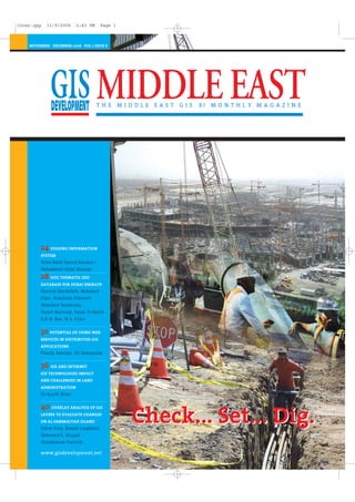
  • 1. Check... Set... Dig.Check... Set... Dig. NOVEMBER - DECEMBER 2006 VOL 2 ISSUE 6 www.gisdevelopment.net 24 DIGGING INFORMATION SYSTEM Walid Khalf Sayeed Barakat / Mohammed Abdul Mannan 28 SOIL THEMATIC GEO DATABASE FOR DUBAI EMIRATE Hussein Harahsheh, Mohamed Elias, AbdulAzim Elniweiri Mohamed Mashroum, Yousef Marzouqi, Eman Al Khatib B.R.M. Rao, M.A. Fyzee 32 POTENTIAL OF USING WEB SERVICES IN DISTRIBUTED GIS APPLICATIONS Pouria Amirian, Ali Mansurian 36 GIS AND INTERNET GIS TECHNOLOGIES IMPACT AND CHALLENGES IN LAND ADMINISTRATION El-Ayachi Moha 40 OVERLAY ANALYSIS OF GIS LAYERS TO EVALUATE CHANGES ON AL SAMMALYAH ISLAND Salem Essa, Ronald Loughland, Mohamed E. Khogali, Abdulmunem Darwish Cover.qxp 11/9/2006 2:43 PM Page 1
  • 2. THEME : Geospatial Convergence:The Next Step 9 - 11 April 2007, Dubai World Trade Center, Dubai, UAE www.mapmiddleeast.org info@mapmiddleeast.org SEMINARS GEOSPATIAL EXECUTIVE LEADERSHIP FORUM OPEN SOURCEOIL & GAS ISPRS CONFERENCE CRITICAL INFRASTRUCTURE PROTECTION & EMERGENCY MANAGEMENT CONSTRUCTION & ENGINEERING PHOTOGRAMMETRY REMOTE SENSING General Enquiry / Information info@mapmiddleeast.org Abstracts / Papers papers@mapmiddleeast.org Registration registration@mapmiddleeast.org Exhibition exhibition@mapmiddleeast.org Abstract Submission 15 January 2007 Paper Acceptance 20 January 2007 Full Paper Submission 28 February 2007 Registration 15 March 2007 IMPORTANT DEADLINES CONTACTS information from imagery ORGANISED BY CO- SPONSOR
  • 3.
  • 4.
  • 5.
  • 6. The construction activity for urban development has seen a shift from over head and sur- face based utility lines to underground utility lines. These underground lines contributed by: telephone, power, cable TV, fibre optics, traffic signals, gas line etc are forming a kind of spider's web. This web gets further complicated in the scenario where deregulation of the services is leading to multiple players providing a given service. These utility lines are often at risk of being damaged unknowingly during the process of excavation or con- struction either at the same place or in the nearby area. This lead to the urban develop- ment work, calling for coordination meet amongst the various service provider prior to any work being undertaken. This was quite evident when the reworking of urban infra- structure like city highways, telephone cable, power line was initiated. All this only vindicates the move by the urban bodies to come up with urban SDIs. The city of Riyadh which has already taken a step in this direction in September 2006, will 'enable public and private agencies to share mapping data and to distribute data changes and updates in near real-time.' The recent news of EU Satellite Centre [EUSC] with Joint Research Centre [JRC] providing scientific support to the international donors planning the distribution of aid in Lebanon through provision of high resolution satellite imageries is a step in this direction. It is said that the JRC and EUSC would establish an SDI for detailed assessment of the damages and reconstruction planning. The Web GIS article 'Digging Information System' for the city of Madinah is an initiative on similar lines with focus on the coordination aspect for on-site construction. The availability of this system on web increases the usability of this system. The Dubai GIS Center under the Dubai Municipality [DM] is the one point source for spatial datasets like: base maps, landuse maps, infrastructure data and operations data. What is impressive the list of government and private partners which are listed as strategic partner to the DM, which would ulti- mately contribute to the updation of the spatial data sets maintained by DM. In Feb 2006, a workshop was organized on SDI for UAE, the initiative which soon after was approved by the Emirates. The Qatar SDI has an excellent system data sharing amongst the participating agencies, where the agencies can publish their data for sharing. The data sharing is regulated to be in the framework of national spatial data standards. These activities are monitored by Center for GIS at Qatar. The common denominator for all the virtues of urban SDI and the various initiatives tak- en would be the service to the stakeholders and the coordination amongst them. The service elements could be influenced by the amount of data which can be accessed through Web GIS Application. The enterprise solutions offered by leading geospatial ven- dors would continue to evolve, with a skeptical look by the general public: 'Will Google Earth or Microsoft Local Live, in future, to provide geospatial tools for utility service man- agement, a small domain compared to the issues they would like to address?' 7G I S D E V E L O P M E N T - M I D D L E E A S T Managing Editor Digging for SDI maneesh.prasad@GISdevelopment.net N O V E M B E R - D E C E M B E R 2 0 0 6 Editorial.qxp 11/9/2006 3:36 PM Page 7
  • 7. 8 G I S D E V E L O P M E N T - M I D D L E E A S T BAHRAIN Postal Dept. goes hi-tech Bahrain joined the interna- tional community in observ- ing the World Post Day (WPD) on October 9th, by fur- ther expanding its postal services. Which included launch of a new GPS naviga- tion system to monitor its fleet of 80 vans in streamlin- ing mail delivery. Under the new hi-tech sys- tem, the postal authorities will be able to track down each van and check the assigned route, timings, speed and distance covered, said Shaikh Bader. The new GPS system auto- matically warns the driver in case of traffic violations, locates his position and checks whether he sticks to the distribution zone assigned to him. The Bahrain Post is com- mitted to enhancing its serv- ices to international stan- dards, said Transportation Ministry Assistant Under- Secretary for Posts Shaikh Bader bin Khalifa Al Khalifa. The number of post offices in Bahrain were also increased to 14 with the opening of a post office in Juffair last month, he told the GDN. "We are now upgrading the services to make remit- tance instantly through elec- tronic channels," said Shaikh Bader and added that people would also receive non-pay- ment notices through the post offices. www.gulf-daily-news.com GIS to be adopted to manage power supply Bahrain is taking steps to handle an anticipated 65 per cent surge in electricity con- sumption over the next six years. Major developments such as Bahrain Financial Harbour and Durrat Al Bahrain are expected to drive the mas- sive increase in demand. Consumption peaked at 1,840mw this year, said Elec- tricity and Water Ministry Under-Secretary Dr Majeed Al Awadi during a meeting of the Bahrain French Business Club (BFBC). Dr Al Awadi said several major plans are underway to help the country cope with the expected increase in demand, including the cre- ation of 15 new substations and upgrading 10 existing ones. Moreover, he also men- tioned about several major strategies which are under- way to help the country cope with the expected increased demand .He said, an upgrade of the customer service sys- tem, set to be finished next year, and the introduction of a GIS by November 2008 would improve the handling of reported faults. Dr Al Awadi admitted upgrading work needed to be done, but said the ministry was battling against low rev- enue margins, old parts of the network, rapid changes in consumption patterns and unauthorised additional loads. He said an upgrade of the customer service system, set to be finished next year, and introduction of a GIS by November 2008 would improve the handling of reported faults." The cus- tomer service system will be upgraded by the first quarter of 2007 and these two will help us a lot and make it eas- ier to correct problems". www.gulf-daily-news.com LEBANON EU helps in reconstruction The European Commission's Joint Research Centre (JRC), together with the EU Satellite Centre (EUSC), is providing scientific support to interna- tional donors planning the distribution of aid in Lebanon. High resolution satellite images have helped the EU compile a preliminary dam- age and needs assessment report for Lebanon. The report was presented at the recent donors' conference held recently in Stockholm. The images reveal that in southern Lebanon 1,489 buildings, 535 road sections, 21 of the 29 bridges over the Litani River and 545 culti- vated fields were either destroyed or damaged. In Beirut 326 residential buildings have been dam- aged or destroyed in the southern suburbs, along with all the runways of Beirut airport and six strate- gic highway sections. According to the report, the damage observed to the roads means access to impor- tant towns, services such as hospitals as well as cultivat- ed fields may be disrupted. The report also points out that the satellite images only show damage to buildings that is visible from overhead; in areas where ground bat- tles took place, considerable lateral damage to buildings is also likely. JRC and EUSC will continue to support the reconstruction effort by establishing a spa- tial data infrastructure to allow for a more detailed assessment of the damages. http://ec.europa.eu/ PAKISTAN NDMA constituted The government has consti- tuted the National Disaster Management Authority (NDMA) to co-ordinate disas- ter management throughout the country. The NDMA has come into being one year after the dev- astating earthquake in the country's north provincethat killed more than 73,000 people. The authority will be formalised through a piece of N O V E M B E R - D E C E M B E R 2 0 0 6 News: Middle East 8-20.qxp 11/9/2006 3:42 PM Page 8
  • 8. 9G I S D E V E L O P M E N T - M I D D L E E A S T legislation.Speaking at a function, Prime Minister Shaukat Aziz said the NDMA would play its role in any dis- aster situation. He said the authority would not only co- ordinate activities to deal with consequences of any disaster but also keep liaison with the donors. www.gulf-times.com Govt to take Chinese help in space technology China and Pakistan will work together in development of space technology and launching of three earth resources prospecting satel- lites in the next five years. The relevant institutions of the two countries have already started necessary spadework to launch the satellites within stipulated period. The two countries have been playing an active role at the regional level as well, strengthening cooperation in the space industry. Pakistan, China and seven other coun- tries signed a treaty for the establishment of Asia-Pacific Space Cooperation Organization (APSCO) last year, and it would take effect upon ratification by five members. In Asia, China is actively engaged in the setting up APSCO, which would be based in Beijing. Eight coun- tries, China, Pakistan, Bangladesh, Indonesia, Iran, Mongolia, Peru and Thailand signed the document last October. Turkey also signed the convention June this year, making it the ninth member of the organization. The APSCO will be formally established after China receives approvals from at least five participating coun- tries' parliaments. The for- mation of the APSCO will be beneficial to further exchanges and cooperation in space technology and its application and promoting economic and social develop- ment, and common prosperi- ty, in the region, he added. APSCO will be a platform to carry out space coopera- tion to make people benefit from space technology and its application. Pakistan and China played a pioneering role in establishing the organization, first of its kind to expand cooperation in space activities in the region. According to the sources, Pak-China bilateral coopera- tion in the space industry could span a broad spectrum of topics of mutual priority. www.adnki.com QATAR GIS award to Qtel Qtel, a Qatar based telecom- munications provider, has won a 'Special achievement in GIS' award for the second time in the last three years, at the Environmental Sys- tems Research Institute's 26th Annual User conference in San Diego, California. GIS is designed to analyse and use data related to a geo- graphical location. For exam- N O V E M B E R - D E C E M B E R 2 0 0 6 The Dubai Department of Tourism and Commerce Mar- keting (DTCM) has launched a new interactive Electronic Map of Dubai on its website. The site provides the options to view online the Interac- tive street map along with it the map is also available in PDF format for those without the Java plug-in on their computers. The interactive version of the map offers a convenient search facility of the major landmarks in the emirate in addition to a handy directory of hotels, hotel apartments, shopping malls, hospitals, diplomatic missions, heritage sites, places of interest, and upcoming mega projects among a host of important points of interest. Areas of interest can be expanded for greater details and printed for hard-copy use. The DTCM Manager Information Technology, Mr. Suhail Buhelaiba, said: "The new facility provides a virtu- al tour of Dubai. It enhances the appeal of the DTCM web- site in the online community. This will come handy to millions of Dubai visitors as well as the residents. The usage of this map will be immense to everyone, especial- ly businesses and tourists." The map has been exclusively designed for the DTCM with the software provided by Belhane, a German Cartog- raphy company. The department has partnered with Easy Map Advertising which will be responsible for marketing the advertising space on the map. The company will also enable a business in Dubai to locate them on the map and provide power-links. www.dubaicityguide.com Interactive e-map 8-20.qxp 11/9/2006 3:42 PM Page 9
  • 9. 10 G I S D E V E L O P M E N T - M I D D L E E A S T ple, in the telecommunica- tions industry, GIS helps Qtel determine a customer's resi- dent location, nearest pay phone or cable network, or the best location to set up a new customer service center. Qtel was selected from over 100,000 GIS users worldwide for the award, which recognises Qtel's effec- tive use of GIS to manage its advanced telecommunica- tions network. Qtel has fast developed GIS technology to help in track- ing the location and charac- teristics of their outside infrastructure and improv- ing access to information when engineering new proj- ects. The company has made rapid strides to improve cus- tomer satisfaction through GIS by providing useful applications for managing different aspects of Qtel services in residential wire- line, GSM networks, inter- exchange transmissions, Triple Play, ADSL coverage and pay phone planning and management. The company has also developed a Telecommunica- tion Access Network Man- agement System (TEAMS 9.4), which successfully con- verted massive amounts of data and drawings and over 50,000 documents into a dig- ital format. The 'TEAMS 9.4' applica- tion is designed to manage the Qtel inside and outside plant and to automate the entire workflow making it faster and more efficient to access geographical data linked to the construction of roads, setting up network cables and other under- ground work, etc and for pro- cessing building permit applications. www.qtel.com.qa SAUDI ARABIA Satellite Navigation system to control air traffic Saudi Arabia is planning to change its civil aviation nav- igation system from ground based to satellite based in phases. According to Muhammad Al-Salimi, Director of air cor- ridors at General Authority for Civil Aviation (GACA), the new system will be imple- mented partially at this stage, as the total shifting to the new international navi- gation system requires time and should pass through dif- ferent phases. Al-Salimi said the King- dom would enter into serious negotiations with a number of countries under the umbrella of the International Civil Aviation Authority to set out laws on the use of satellites for air navigation. He said the Kingdom would participate in the activities of the International Civil Aviation Organization to develop and modernize civil aviation systems, set out new regulations, and modernize the management of air traffic. Al-Salimi made this statement while addressing a meeting of the working group to implement future navigation systems. The meeting was organized by the GACA. The shift from ground- based system to satellite- based requires qualified manpower. The GACA will conduct intensive training courses for its air traffic con- trol staff in satellite and digi- tal communication.He said the authority was currently applying satellite communi- cation in some airlines. The objective is to help airlines save time by reducing flight duration. This will also increase air traffic and attract foreign airline com- panies, he explained. Opening the meeting, GACA President Abdullah Al- Rehaimy said he was looking forward to setting out mech- anisms that help Arab civil aviation administrations and airline companies to set up air corridors to provide air- link to aircraft equipped with FANS1A satellite air naviga- tion systems in Arab skies. "Arab countries will bene- fit a lot by applying this modern air navigation sys- tem in terms of economic and operational aspects and the benefit will reflect direct- ly on air navigation service providers as well as airlines and other users," Al-Rehaimy said. Spelling out the benefits, he said direct use of air corri- dors would help save fuel, reduce the time for flight, increase air corridor capacity, help open new air corridors and thus help increase air traffic and financial returns of Arab aviation authori- ties."It will also reduce the work of aviation control staff; achieve more efficiency in communication between air control staff and pilot as they will use digital data instead of sound data. This will also lead to improving aviation security and safety," he added. Al-Salimi said the meeting was aimed at promoting coordination between air control offices in Arab coun- tries in preparation to apply the new satellite system. He said total reliance on the satellite air navigation system would be achieved by 2015. www.arabnews.com Galdos to develop Riyadh's SDI Galdos Systems announced recently that it had been con- tracted to develop an urban spatial data infrastructure (SDI) within the city of Riyadh, Saudi Arabia. The urban SDI will enable public and private agencies to share mapping data and to distribute data changes and updates in near real-time. The objective of this project is to enable users of the N O V E M B E R - D E C E M B E R 2 0 0 6 8-20.qxp 11/9/2006 3:42 PM Page 10
  • 10. 11G I S D E V E L O P M E N T - M I D D L E E A S T system to significantly reduce data redundancy cost and increase productivity through access to timely data."The city of Riyadh is truly an innovator in urban management," said Ron Lake, Chairman & CEO of Galdos Systems Inc. "By developing an urban SDI, public and pri- vate agencies can collect and share real-time data while dramatically decreasing con- cerns of data redundancy and accuracy." The urban SDI will enable agencies like, Riyadh Water & Sewage, Arriyadh Develop- ment Authority, and Saudi Telecom to share only data in real time that is of interest to specific participants to enhance their decision-mak- ing processes. Participants cannot modi- fy data that does not belong to them. The data does not emerge from a centralized warehouse; rather it is a dis- tributed system, utilizing the latest collected data of each participating organization. www.galdosinc.com TURKEY u-blox expands its presence u-blox AG, a provider of GPS receiver technology announ- ced recently that it has expanded its distribution network into new growth market by signing agree- ment with electronics dis- tributor Kayra Elektronik of Turkey. Kayra Elektronik distrib- utes GPS and GSM-related products such as antennas, connectors, LCD displays and cables. The company focuses on distributing mobile com- munications and positioning industries products. " u-blox' innovative posi- tioning solutions will benefit both the GPS and GSM mar- kets immensely, both of which constitute prime tar- get markets here at Kayra" said Fatih Coksak, Product Manager at Kayra Elektronik. www.theautochannel.com UAE ANTRIX to distribute CARTOSAT-1 imagery Global Scan Technologies (GST), a Dubai-based compa- ny providing Remote Sensing and GIS technologies in the Middle East, recently announced that it had signed a contract with India's ANTRIX Corporation Limited, a provider of satellite images worldwide and the market- ing arm of the Indian Space Research Organization (ISRO) under the Department of Space, Government of India. GST's agreement with ANTRIX includes distribution of Cartosat-1 imagery with 2.5m resolution in both pan and stereo modes. The unique high-resolution along-track stereo imaging capability of Cartosat-1, car- ried out for the first time anywhere in the world, enables generation of Digital Elevation Models (DEM) and other value-added products. The data from Cartosat-1 is expected to provide enhanced inputs for large scale mapping applications and stimulate newer applica- tions in the urban and rural development, land and water resources manage- ment, disaster assessment, relief planning and manage- ment, environment impact assessment and various oth- er Geographical Information System applications. The data can be used for genera- tion and updating of large- scale topographic maps. "Our agreement with ANTRIX allows us to distrib- ute Indian Satellite imagery in the UAE and many other Middle East countries", said Dr.Hussein Harahsheh of GST. www.ameinfo.com Dubai Municipality rolls out EPIMS Dubai Municipality's IT department has launched the first phase of the Engineering Projects Infor- mation Management System (EPIMS) within the organisa- tion. The system enables all the staff and clients to communi- cate through an integrated electronic channel, resulting in significant time savings and error-free completion of transactions. It also facili- tates easy access to informa- tion, leading to better deci- sion making. Hussain Lootah, Director General of Dubai Municipali- ty, said, "We are continuous- ly committed to adopting the latest in information technology to enhance our customer services. “The new project allows various departments in the munici- pality such as Contracts & Purchasing, General Projects, and Finance, to submit their applications electronically. These applications range from accreditation materials, graphics, plans, programmes and reports about the imple- mentation of the engineer- ing projects, in addition to financial requirements. EPIMS facilitates more effective internal communi- cation between all depart- ments of Dubai Municipality. The departments that will benefit from the implemen- tation of this system include Contracts & Purchasing, Gen- eral Projects, Finance, Histor- ical Buildings and Coastal N O V E M B E R - D E C E M B E R 2 0 0 6 8-20.qxp 11/9/2006 3:42 PM Page 11
  • 11. 12 Management, in addition to some of the external users. Further, it provides direct, detailed and accurate infor- mation for contractors and consultants," Lootah added. The first phase of the EPIMS began in August 2006 and Dubai Municipality's IT department is now working on implementing the second phase of the system to cater to the requirements of other engineering departments in the municipality. www.cpilive.net Dubai Land Department implements DMS Dubai Land Department has digitizes all the documents by implementing a docu- ment management solution from FileNet, a provider of Enterprise Content and Busi- ness Process Management solutions. This will speed up land and property transactions in Dubai. This system helped Dubai Land Department overcome several challenges, including fragmentation of information as a result of data being scattered in vari- ous systems and forms, slow customer transaction pro- cessing time, and the need to meet increasing regulations. With 1.5 million pages rep- resenting the backlog of paper documentation already migrated to a FileNet system and an additional 3.5 million pages set to be added from the on going New Dubai real-estate project. 'With more than 54,000 plots registered in Dubai, it was becoming increasingly unsustainable to manage the associated paperwork and documents. Accessing impor- tant documentation was proving to be a time-con- suming process for internal and external users alike, which persuaded us to digi- talise all documents of the department,' said Khalifa Ahmed Al Zuraim, Head of IT Centre, Dubai Land Depart- ment. 'We conducted a com- prehensive technical evalua- tion of solutions from 10 companies, and found that FileNet's advanced Docu- ment and Content Manage- ment solution was easily the most reliable and flexible.' 'FileNet is pleased to asso- ciate with Dubai Land Department for this land- mark project,' said Alessio Gallo, International Sales Director, South Europe, Mid- dle East and Africa, FileNet. FileNet applications are integrated with Oracle busi- ness applications, the depart- ment's internal GIS system, and Dubai Municipality's GIS system enabling access to land documents. The imple- mentation was carried out by Gulf Computers, a FileNet Partner in the Middle East. www.ameinfo.com GPS Industries Inc signs MOU for investment GPS Industries, Inc., the inno- vator of Wi-Fi enabled GPS systems for golf courses and residential communities, announced on recently that it has signed a Memorandum of Understanding (MOU) with an affiliate of a large investment group located in the UAE for a US$10M private placement for the Company's preferred stock. Management believes that the investment from the Dubai group will lead to additional investments from other investors. http://press.xtvworld.com YEMEN Managing water resources As many water basins in Yemen are facing water shortages due to changing climatic conditions and over- use of ground waters, a need to develop and properly manage available water resources is being felt. Considerable investments are allocated for constructing and rehabilitating water storage structures, to enhance ground water dis- charge, for expand irrigated areas, and providing water for other uses. To understand the effect of dams on water status in giv- en water basin, various inves- tigations are required for determining surface water and groundwater hydrology, and subsequently advising proper water resource man- agement strategies. In a study of Sawan water- shed, which is located in Sana'a basin, the effect of three small dams on shallow groundwater discharge was observed. To study the effect of dams on groundwater dis- charge, static water levels in a number of open wells was observed in 2000 and 2001. Static water level (SWL) of wells near Mukhtan, Konaz- er, Beryan dams were signifi- cantly affected by the dis- tance from the dams. The SWL of wells closer to Mukhtan dam was 9 m while SWL of well at distances of about 5.7 Km from the dam was 22.6 m. In the case of Beryan dam, SWL were 7.9 m and 11.7m for wells at dis- tances 0.3 km and 6.1 km from the dam, respectively, while SWL was found at 9 m in wells near Konazer dam and 22.3m in wells at 4.5 Km from the dam. This indicates the presence of groundwater discharge, especially in the areas near the dams. This study recommends documenting hydroclimatic data in order to establish an information database for major watersheds, and to carry out comprehensive studies and investigations on the effects of dams. An emphasis is required to uti- lize mathematical models, GIS and other programs in the Rapid Risk Assessment program of watershed and dams. http://yementimes.com N O V E M B E R - D E C E M B E R 2 0 0 6G I S D E V E L O P M E N T - M I D D L E E A S T 8-20.qxp 11/9/2006 3:42 PM Page 12
  • 12. ROLTA ● ● ● ● ● ●USA:1-678-9425000 Canada:905 - 361 - 2878 Benelux:31 - 23 - 5571916 Germany:49 - 6102 - 299985 UK:44 - 1189 - 450011 Dubai:971 - 4 - 3915212 SaudiArabia:966 - 1 - 2421212 Certification Q M S C E R T I F I E D ISO 9001 : 2000 GLOBAL PHOTOGRAMMETRY, GIS AND UTILITIES & COMMUNICATION SERVICES
  • 13. 14 BUSINESS Leica Geosystems receives Frost & Sullivan Market Leadership Award Frost & Sullivan, a New York- based consultancy firm, con- ferred London Market Lead- ership Award in the Laser Tracker Segment on Leica Geosystems in London recently. Already the recipient of the 2004 Frost & Sullivan "Indus- trial Automation Product Innovation of the Year" award for its Portable CMM line of products, Leica Geosystems was selected in 2006 for its sales growth and its stress on emerging tech- nologies. www.leica-geosystems.com Rolta gets ISO/IEC 20000-1:2005 ITSM certification India based Rolta is the 21st company in the world certi- fied by BSI with "ISO/IEC 20000-1:2005 IT Service Man- agement standard". BSI, the largest and most respected management systems regis- trar in the world is supported by BSI Group offices, con- ducted the assessment for the certification. Rolta had been certified for BS 15000 for its IT Service Management operations. This new certification is an upgrade of BS 15000 stan- dard, and describes an inte- grated set of management processes for effective delivery of services. ISO 20000 is aligned with and complementary to the process approach defined within the IT Infrastructure Library (ITIL) from The Office of Government Commerce (OGC), UK. Vinay Sawarkar, Sr. Execu- tive Director - Rolta, speaking on the occasion of certifica- tion said, "ISO 20000 is increasingly seen as the quality standard for IT Ser- vice Management and many companies are striving to adopt ISO 20000, not only for their own benefit, but also to help qualify and choose sup- pliers and partner organiza- tions. This certification reaffirms Rolta's endeavor to adhere to the Best IT Service Manage- ment Practices in the world, for its customers, partners and stakeholders". www.rolta.com OSI Geospatial gets contract from US Dept. of Defense OSI Geospatial Inc. recently announced on September 27 that its U.S. systems opera- tions had been awarded a three-year contract totaling approximately US$3.8 mil- lion by the US Defense Threat Reduction Agency (DTRA). Under the contract terms, OSI will develop a GPS Denied Navigation and Mapping System for the DTRA. "OSI is into development and production of Naviga- tion and Mapping systems for international military and commercial applica- tions. This contract will enable OSI to evolve our lead- ing edge technology into the Hand-Held/Wearable Per- sonal Navigation Systems market," said Ken Kirk- patrick, President and CEO of OSI Geospatial. www.osil.com ISRO gets contract to launch 16 nano satellites Around September 2007, India's rocket Polar Satellite Launch Vehicle (PSLV) will carry a 100 kg capsule as an additional passenger into space. The capsule will unfurl a series of 16 nano satellites that weigh between one kg and five kg. The University of Toronto, Canada, leads a team of aca- demic institutions that would build these satellites, designed to conduct research on outer space, including micro-gravity experiments. It has contracted out the launch to the Indian Space Research Organisation (ISRO). Nano satellites weigh less than 10 kg and multiple satellites work together as a network in space. In some cases, these formations of nano satellites are connected to a bigger satellite, called the mother, for communica- tion purposes. The PSLV rocket has piggy- backed micro satellites that weigh up to 100 kg to space, but this would be India's first experience in launching nano satellites. "We have several small satellites from universities in India and abroad that will be launched over the next few years," an official said. ISRO will loft a 50 kg Indonesian remote sensing satellite with Cartosat-2, the home-grown one-metre reso- lution remote sensing satel- lite, when the PSLV is launched next month. In the past, India's rockets have car- ried several micro satellites weighing less than 60 kg, including the Korean KIT- SAT-3, German DLR-TUBSAT, BIRD of Germany and PROBA of Belgium, into their intend- ed orbits. www.dnaindia.com Hirayama to head TPS-Australia Tony Hirayama, Topcon Posi- tioning Systems' (TPS) Execu- tive Vice President, has assumed the role of President and CEO of TPS-Australia. He will also have the title of President and CEO with KEE Technologies, which joined TPS on October 3 this year. Les Mann, former KEE Presi- dent and CEO, will be the new Chief Operating Officer at KEE. The announcement was made by Ray O'Connor, TPS President and CEO, who will be Chairman of the TPSA board. www.topconpositioning.com N O V E M B E R - D E C E M B E R 2 0 0 6G I S D E V E L O P M E N T - M I D D L E E A S T News: World 8-20.qxp 11/9/2006 3:42 PM Page 14
  • 14. 15G I S D E V E L O P M E N T - M I D D L E E A S T ESRI President awarded Henry Shaw Medal ESRI President Jack Danger- mond was awarded the Hen- ry Shaw Medal in a ceremo- ny on September 13, 2006, at the Missouri Botanical Garden in St. Louis, Missouri. ESRI's ArcInfo and ArcView software allow the garden to integrate its vast resources of expert knowledge and herbarium data with climate, soil, and elevation data to analyze plant geographic ranges and patterns of diversity. Using ESRI's ArcIMS tech- nology, the garden created a Web interface for sharing its plant data with the world. Not only does this allow it to provide global mapping capabilities for all the speci- mens in its database, but it can also customize interac- tive maps with various envi- ronmental data layers, giving the garden's col- leagues invaluable resources for prioritizing their collec- tion strategies. Presented since 1883, the medal recognizes those who have made significant contri- butions to the Missouri Botanical Garden, botanical research, or conservation. It is named in honor of Henry Shaw, a successful St. Louis businessman who founded the Missouri Botanical Gar- den in 1859. www.esri.com Tele Atlas expands operations Tele Atlas officially inaugu- rated Tele Atlas Polska, the company's East European headquarters, with office openings in Warsaw and Lodz on September 20. Tele Atlas Polska's opera- tions were initially formed through Tele Atlas' acquisi- tion of Warsaw-based PPWK GeoInvent in October 2005. PPWK GeoInvent developed a mobile mapping system, which speeds the data cap- ture and map update process and helps Tele Atlas quickly deliver high quality maps that incorporate data, images and other valuable local content to customers and partners around the world. Tele Atlas Polska is respon- sible for developing mobile mapping and image process- ing technology. The compa- ny's worldwide Mobile Map- ping and Image Technology Centre in Lodz manages the research and development of mobile mapping technology, the production of mobile mapping units and oversees image processing. The War- saw office is responsible for database operations in Poland and the Baltic states, serving as the development platform for Central and Eastern Europe. Tele Atlas Polska currently has more than 150 employees and con- tract operators and plans to expand its operations with employees specialised in information technology and GIS. www.teleatlas.com Trimble reports 3rd Q '06 growth of 25 % Trimble has announced the results for its third quarter 2006, ended September 29, 2006. Revenue for the third quarter of 2006 was $234.9 million, up 25 percent from revenue of $188.5 million in the third quarter of 2005. Operating income for the third quarter of 2006 was $36.3 million, up 10 percent from the third quarter of 2005. Net income for the third quarter of 2006 was $25.3 million, up 25 percent when compared to net income of $20.2 million in the third quarter of 2005. Earnings per share for the third quarter of 2006 were $0.43, up approximately 23 percent compared to earn- ings per share of $0.35 in the third quarter of 2005. Earn- ings per share in the third quarter of 2006 were nega- tively impacted by approxi- mately $0.03 due to the adoption of FAS 123R and by approximately $0.03 due to higher amortization of intan- gibles. http://trmb.client.shareholder.com Intergraph takeover gets antitrust clearance Intergraph Corporation, a provider of spatial informa- tion management (SIM) soft- ware, announced recently that the US antitrust agen- cies had granted early termi- nation of the waiting period under the Hart-Scott-Rodino Antitrust Improvements Act of 1976, as amended, effec- tive September 26, 2006, in connection with the Compa- ny's pending acquisition by a private investor group led by Hellman & Friedman LLC and Texas Pacific Group in a transaction valued at approximately $1.3 billion. Intergraph had announced on August 31 that it has signed a definitive agree- ment to be acquired by the investor group. Intergraph's Board of Directors had approved the merger agree- ment and had resolved to recommend that Inter- graph's stockholders adopt the agreement. The transaction remains subject to the receipt of shareholder approval as well as the satisfaction of other previously disclosed closing conditions. The transaction is expected to close in the fourth quarter of 2006. Terms of the transaction call for stockholders to receive $44 cash per share. If approved, the move will make private one of Huntsville's longtime pub- licly traded companies. www.intergraph.com N O V E M B E R - D E C E M B E R 2 0 0 6 8-20.qxp 11/9/2006 3:42 PM Page 15
  • 15. N O V E M B E R - D E C E M B E R 2 0 0 616 G I S D E V E L O P M E N T - M I D D L E E A S T eSpatial and TerraNor to deliver iSMART products eSpatial, a geospatial soft- ware and technology compa- ny and TerraNor, a company providing software for GIS, remote sensing and digital mapping, signed a Reseller Agreement. Under the agreement Terra- Nor will act as a reseller for iSMART5, in the Nordic countries (Denmark, Finland, Iceland, Norway, Sweden, Greenland). eSpatial's iSMART product supports a number of deployment mod- els, which include Pure Web and Customized Client with- in a scalable, role-based and secure environment. The architectural features delivered with iSMART address standard IT require- ments for the deployment of enterprise business applica- tions. iSMART provides an ideal enterprise grade hosted serv- ices delivery platform for geospatial applications. Delivered applications and services can also be provided to conform with the Open Geo Spatial Consortium (OGC) Web Services stan- dards. www.espatial.com 3001 Inc. to acquire LandAir 3001, Inc., announced recent- ly that after working togeth- er for many years, including an eighteen month period where LandAir Mapping, Inc. (LandAir) acted as the fourth business unit of 3001 provid- ing all flight operations and related services, 3001 has finalized the agreement to wholly acquire LandAir. LandAir, a small geospatial business successfully run by President Tom Olive since 1988, is a contract holder under US Department of Agriculture's National Agri- cultural Information Pro- gram (NAIP) and as such, was awarded the largest number of states for high-resolution aerial photo acquisition. LandAir also successfully managed dozens of other projects in the last years, elic- iting praise from clients all around. LandAir teaming with 3001 began in 2003, when the two firms joined forces to support the U.S. Army Corps of Engineers in the acquisition and processing of natural col- or imagery at 1 meter resolu- tion imagery for the entire island of Puerto Rico. The two companies' production staff and management developed trust in a shared vision for high quality imagery products. Mr. Olive will stay on to run 3001's LandAir Mapping business unit. "I am looking forward to a little extra time that this acquisition affords me to consider future sensor investments. The economies we enjoy by joining forces will allow us to spend more time listening and learning of new ways to save time and money for our clients", says Tom Olive. www.3001inc.com Global study shows benefits of location intelligence According to a survey con- ducted by MapInfo Corpora- tion, a provider of location intelligence solutions, and BusinessWeek Research Services, 64 percent of business executives believe that location intelligence can improve business processes, and 21 percent are planning to investigate it in the next year. 1,700 business executives participated in this interna- tional study to gauge the role that technology can play in delivering powerful, busi- ness-relevant location intelli- gence to leading organiza- tions. 80 percent of data that an organization uses to make key decisions to improve its efficiency, effectiveness and profitability has a location- based component. Optimizing information such as a ZIP code, telephone number or address enables companies to answer critical questions such as: Where can I find more of my best cus- tomers? Where are competi- tors impacting my business? Where is my newest product or service most valuable? For instance, MasterCard Worldwide relies on the MapInfo Envinsa location intelligence platform to pow- er its worldwide ATM Locator service. Envinsa replaced MasterCard's previous online and phone ATM Locator serv- ices with a more integrated platform for deploying loca- tion technology across the entire organization. As a result, MasterCard was able to reduce costs and provide enhanced customer service to millions of customers. www.mapinfo.com Trimble acquires Visual Statement Trimble announced recently that they had acquired pri- vately-held Visual Statement Inc. of Kamloops, British Columbia, Canada in an all- cash transaction. Visual Statement provides state-of-the-art desktop soft- ware tools for crime and col- lision incident investigation, analysis and reconstruction, as well as statewide enter- prise solutions for reporting and analysis used by public safety agencies. The company is an addi- tional investment in the Mobile Solutions business segment that supports Trim- ble's strategy of providing productivity solutions for mobile workers. Financial terms were not disclosed. The Visual State- ment acquisition comple- ments Trimble's subsidiary, Advanced Public Safety (APS). www.trimble.com 8-20.qxp 11/9/2006 3:42 PM Page 16
  • 16. N O V E M B E R - D E C E M B E R 2 0 0 6 17G I S D E V E L O P M E N T - M I D D L E E A S T APPLICATION Satellite pics help claiming higher compensation Roughly 140 kilometre from Mumbai, the capital city of Indian state of Maharashtra, farmers are turning to tech- nology to fight for their rights. Four months ago, the farm- ers of Pen taluka in Raigad district were told the state government was acquiring their land to help build the 25,000 acre Maha Mumbai Special Economic Zone (SEZ). That's when an activist of the SEZ Hatao Virodh Samiti, Arun Shivkar, logged on to Google Earth. "We used Google technology to prove to the authorities that the land is fertile," said Shivkar. Shivkar says initially state authorities claimed that only a small portion of the ear- marked land is fertile and that some parts of it is sub- merged by salty creek water, meaning lower compensa- tion for the farmers. But Google Earth has come to the rescue and its satellite pictures clearly indicate crop areas. This has helped farm- ers back their claims for high- er compensation. The tech- nology has also brought together farmers from 45 vil- lages to put up a common front and protest the acquisi- tion of their land. The ingenious ways in which farmers in Maharash- tra are using Google Earth to fight for their rights is per- haps a testament to how technology is truly flattening the world. www.ibnlive.com Satellite imageries reveal, green means rain Scientists from Natural Envi- ronment Research Council (NERC)-funded Climate and Land Surface Interactions Centre (CLASSIC) have found that the presence of green vegetation has a major influ- ence on the amount of rain that falls in the Sahel region of Africa, south of the Sahara desert. Rains at the start of the growing season cause vege- tation growth. This encour- ages a feedback loop as the greener the vegetation becomes, the greater the amount of rain that falls. This important new research could help us to pre- dict future droughts in Africa. The research can be used to aid regional and international forecasts for rain-starved regions. Using satellite technology, Dr Sietse Los and colleagues at CLASSIC worked with NASA to develop a dataset covering 18 years of vegeta- tion greenness records. They combined these records with rainfall data in the region over the same period -- from 1982 to1999. The resulting analyses show, for the first time, that rainfall amounts vary between 10% and 30% more when the land is green, and decreases by a similar amount when conditions are dry and there is little green vegetation growing. The research was published in Geophysical Research Letters (USA), August 2006. www.nerc.ac.uk New crop insurance tools made available The US Department of Agri- culture has made available two new risk management tools for pasture, rangeland and forage in a select group of states for a pilot program, beginning with the 2007 crop year. The rainfall index insur- ance program and the vege- tation index insurance pro- gram, offered by USDA's Risk Management Agency, will allow livestock producers to purchase insurance protec- tion for losses of forage. "These new insurances tools will help farmers and ranchers, especially with operations located in drought-impacted areas, to improve their risk manage- ment capabilities," said U.S. Agriculture Secretary Mike Johanns. The rainfall index program will be tested in 220 counties in Colorado, Idaho, Pennsyl- vania, South Carolina, North Dakota and Texas. The vege- tation index insurance pro- gram will be tested in 110 counties. And is based on satellite imagery as a means to measure expected produc- tion losses. www.vafb.com Website shows damage inflicted areas If a picture is worth a thou- sand words, digital satellite imagery could inspire tomes' worth of new environmental policies. At least that's the hope of the designers behind the 'Atlas of Our Changing Environment' A unique new Web site that uses a digital map frame- work to catalog damage inflicted on the Earth over the last few decades, (http://na.unep.net/digital_a tlas2/google.php). "It is as simple as seeing is believing," said Patrick Joseph, an environmental journalist who writes a blog for the nonprofit Sierra Club. "You can read a million times over that the Amazon is being deforested, but satel- lite imagery really helps give you an idea of the scale on which it is happening." The atlas's visual evidence of destruction is already helping some environmental 8-20.qxp 11/9/2006 3:42 PM Page 17
  • 17. N O V E M B E R - D E C E M B E R 2 0 0 618 G I S D E V E L O P M E N T - M I D D L E E A S T groups get the word out about their issues. Sierra Club, for instance, has used images from the atlas in its member magazine, Sierra. The new site is based on Google Earth. The U.S. branch of the United Nations Envi- ronment Programme (UNEP) partnered with Google to cre- ate a "layer" of data that users can navigate using Google Earth or view in a Web browser. news.nationalgeographic.com NASA probes origin of hurricanes The NASA- backed mission has set up three radars one in landlocked Niger's capital Niamey, the one in Kawsara on the Senegalese coast, and one on the Cape Verde Islands and is also flying planes into the centre of the depressions. The objective is to understand how hurri- canes that slam into the southeastern United States and the Caribbean are formed in West Africa before they go bowling across the Atlantic. The data provided by these radars will enable scientists for the first time to map more fully the atmospheric conditions as Atlantic hurri- canes are born and through their life cycle. Previous attempts to understand the phenomenon have relied on satellite data, which can show what is happening on top of clouds but not inside them. The study could help forecasters better predict devastating hurricanes like Katrina. "This is the first time with aircraft, with radars on the ground, that we can look inside these disturbances. And once you understand what's happening inside you have a better chance of pre- dicting," said Greg Jenkins, a specialist in tropical meteor- ology from Howard Universi- ty, Washington. Paul Kucera from the Uni- versity of North Dakota, who has studied weather patterns in Papua New Guinea, the South China Sea and around the Amazon, said, "If we can capture the atmospheric con- ditions of the storm, the storm structure, how they evolve over the African conti- nent and just off the coast, our objective is to distinguish between those that stay together and those that dissi- pate." http://timesofindia.indiatimes.com Satellites to monitor land use in Beijing Beijing will use three satel- lites to monitor land use as part of a crackdown on illegal real estate development activities, a local land official has said. Starting November, Beijing will investigate and prose- cute major cases of illegal use of land, especially those that violate government plans or national industrial policies and those that infringe on farmers' legitimate rights as told by An Jiasheng, Director of the Beijing Municipal Bureau of Land and Resources. Authorities can now avail themselves of satellite remote sensing technologies to discover and prevent the illegal use of land, An told a conference. The Chinese central gov- ernment tightened control over land after the economy grew 10.9 percent in the first half, promising to penalize local officials who fail to stop or investigate land use trans- gressions. The Ministry of Land and Resources laid down in a recent circular that local gov- ernments must not approve more land for construction in 2007 than they did in 2006. "The principle is to strengthen macro-economic control and use land resources economically," it said, adding that localities must make use of land "sci- entifically and rationally" to protect farm land and land for other agricultural purposes. It urged localities to "act conjointly" with the State Council in implementing macro-economic control poli- cies and prevent runaway fixed-asset investment. www.chinadaily.com.cn CRISP detects hot spots in wildlife reserve Singapore`s Satellite Centre for Remote Imaging Sensing and Processing (CRISP) on September 6 detected six hot spots in a wildlife reserve in Kendawangan, Ketapang District, West Kalimantan Province.The Singaporean CRISP also detected some a hot spot at a national park in Aur Kuning, Ketapang Dis- trict, in the province, accord- ing to information from the West Kalimantan forestry service`s forest fire control unit here on Thursday. There were a total 58 hot spots in West Kalimantan, and 42 of them were in Keta- pang District. Some six hot spots in Bengkayang District, five hot spots in Pontianak District and another five hot spots in Sanggau district. Head of the West Kaliman- tan Natural Resource Conser- vation Agency (BKSDA) Awen Supranata said that cloud seeding would contin- ue be conducted to trigger rain in the forest fire areas. Awen Supranata said the cloud seeding process has been carried out from Sep- tember 1-7, 2006, to put out forest fires among other things in Bengkayang, Sin- tang, Pontianak, Pontianak and Ketapang. "About 20 tons of artificial salt are dropped every day to trigger cloud seeding. The success rate is around 80 per- cent," he said. www.antara.co.id 8-20.qxp 11/9/2006 3:42 PM Page 18
  • 18. N O V E M B E R - D E C E M B E R 2 0 0 6 19G I S D E V E L O P M E N T - M I D D L E E A S T PRODUCT Telogis launches OnTrack4 Telogis, a provider of on demand web-based GPS tracking systems, has released the advanced ver- sion of OnTrack, its fleet tracking, productivity, and management solution, now integrated with GeoStream mapping technology. Added key features of OnTrack4 include: NAVTEQ ultra fast premium maps with free quarterly updates; "SEARCH!" Instantly find vehicles, drivers, and key locations; Unlimited user defined map sizing for wall mounted dispatch monitors; and user defined reports with automated alerts and reporting tools. www.telogis.com MapInfo releases MapMarker Plus v12.0 MapInfo Corporation intro- duced on August 24 Map- Marker Plus v12.0, a geocod- ing tool. MapMarker Plus v12.0 outperforms current geocoding technology, adding a new patent-pend- ing algorithm that more pre- cisely identifies locations. MapMarker Plus v12.0 delivers data-building tools and interpolation method- ologies that bring companies as close as 75 feet on average to a given address, closer to its actual location on the ground. In addition, this ver- sion includes the optional MapMarker ParcelPrecision data set, the ground-level data available containing forty-four million address points www.mapinfo.com Western Europe map from Tele Atlas Tele Atlas announced recent- ly that it had reached a major European milestone by deliv- ering complete digital map coverage of Western Europe. With the addition of detailed Ireland and North- ern Ireland maps to the exist- ing database of countries, Tele Atlas European maps now cover more than 7.8 mil- lion total kilometers, the equivalent of traveling around the Equator 195 times or a return trip to the moon 10 times. Within Western Europe, the database now reaches more than 386 million inhabitants, includes 1.7 million 'standard' points-of-interest (POIs) and nearly 90 percent of all house numbers across the region. www.teleatlas.com Autodesk unveils Topobase 2007 Autodesk, Inc. announced on September 12 the release of Autodesk Topobase 2007 infrastructure design and management solution. Built on Autodesk Map 3D and Autodesk MapGuide Enterprise software, Autodesk Topobase 2007 addresses the challenges faced by organizations that collaborate on infrastructure projects, such as water or wastewater networks, by enabling teams to share spa- tial information across departments. Topobase customers can see the big picture with a more integrated view of all of their enterprise data, and improve productivity and bottom line results by com- pleting projects faster and maintaining assets more efficiently. www.ibnlive.com NetVIEW for Google Earth launched MWH Soft, a provider of environmental and water resources applications soft- ware, announced the release of NetVIEW, a geospatial information viewing, distri- bution, and management software that facilitates deployment and analysis of GIS data and modeling results in Google Earth. Initially introduced for InfoWater, the industry's ArcGIS-centric water distri- bution modeling and opti- mization software, NetVIEW delivers the ability to seam- lessly combine mapping, GIS and modeling data with Google Earth in an integrated environment via an intuitive interface. The information displayed can then be interactively queried online. Built using Component and XML tech- nologies, NetVIEW gives water utilities fast access to mission-critical GIS and mod- eling information as well as extensive data reporting capabilities critical to sup- porting water distribution management activities. www.mwhsoft.com 'Mobile Earth' mapping service from LocatioNet 'Mobile Earth', a mapping and information service has been launched on September 6 for Vodafone Germany's mobile subscribers. The service, available on Java-enabled devices, has been created by LocatioNet Systems Ltd., a provider of mobile mapping and location applications, and is using content from TeleAtlas. The Mobile Earth service enables mobile users to view any address in Germany over full colour maps or high reso- lution aerial photos, calcu- late the best routes between addresses and view the results on a map, in addition to searching and viewing over four hundred thousand 8-20.qxp 11/9/2006 3:42 PM Page 19
  • 19. N O V E M B E R - D E C E M B E R 2 0 0 620 G I S D E V E L O P M E N T - M I D D L E E A S T points of interest in Ger- many. Mobile subscribers can now access all the map- ping information that was previously only available from their PC, using an opti- mised user interface on their mobile phones. The Mobile Earth applica- tion requires a single over- the-air download from the Vodafone Live! mobile portal, just like a mobile game. The application has an advanced Java-based user interface with maps rapidly delivered to the user's handset from the central server over the wireless network, giving the mobile user the feeling that the entire mapping and aeri- al photo content is stored on his handset. www.locationet.com Topcon unveils all-new total station series The all-new total station series from Topcon offers the ultimate solution for demanding tasks on the job site. Designed as complete robotic systems, the GTS- 900A and GPT-9000A series include Topcon's new FC-200 field controller and RC-3 tracking system. The GPT-9000A robotic total station provides precise reflectorless measurement up to 2,000 meters - more than 6,500 feet (1 miles) - and can easily focus on small objects like power lines. The onboard computer, with a bright, full-color touch- screen display, and faster ser- vo motor technology improve field productivity. The GTS-900A series reflec- tor-only instruments are available with the same sys- tem components. www.topconpositioning.com GeoPerspectives from Infoterra and BlueSky Infoterra Ltd and BlueSky Ltd have launched GeoPerspec- tives, a suite of airborne acquired geospatial data. The suite is delivering the next generation of data for England & Wales using the latest digital imaging technology. This enables the simultane- ous capture of RGB and colour infra-red imagery and, via automated processing, the rapid creation of digital terrain and surface models. "We have already updated over 30% of the original base- line survey, which puts us well ahead of our five year update schedule," said Dave Fox, CEO of Infoterra Ltd.s GeoPerspectives offers a range of image resolutions to meet diverse user require- ments; from National Per- spectives datasets at 25cm resolution to ultra high-reso- lution Urban Perspectives detailed enough to view road markings and street furni- ture. Furthermore, the national coverage is the only orthorectified aerial photog- raphy collection with a guar- anteed five year update pro- gramme. GeoPerspectives data is already in use within government, commerce and academia, including the Department for the Environ- ment Farming and Rural Affairs (Defra), Highways Agency, Yorkshire Water and over 240 Local Authorities. www.prnewswire.co.uk Karttakone’s map series for Nordic countries Karttakone has produced map series covering all Nordic countries including Denmark, Finland, Norway and Sweden that can be used as background maps in GIS- applications, in www-servic- es, through Online Services, or as Media Maps. The cartographically high quality datasets are based on Navteq data and include all roads with their names for all of the Nordic Countries. The series are produced in 1:35 000 and 1:250 000 scales. The data products are delivered in tiff-raster format, as pdf- vector files or through Online services directly from the Karttakone server. www.karttakone.fi Japan launches spy satellite Japan launched its third intelligence-gathering satel- lite on September 11, enhanc- ing its ability to monitor neighbouring North Korea two months after Pyongyang shocked the region with a barrage of missile tests. Japan's space agency, JAXA, launched the optical satellite from the southern island of Tanegashima, adding to a pair of satellites that were fired into orbit in March 2003. Two other satel- lites were lost when a rocket failed in November that year. A further radar satellite is set to be launched later this year, completing the set of four. The optical satellite will be able to differentiate objects a meter (yard) or more in diameter, although this level of resolution is far outclassed by U.S. military satellites. A ban on defense use of space dating from the 1960s has hampered Japan's ability to develop high-tech hard- ware. With two similar satellites in orbit, the Japanese govern- ment will be able to monitor any point on Earth once a day, an official at Japan's Cabinet Satellite Intelligence Center said. Japan planned its spy satellite program following North Korea's 1998 launch of a ballistic missile that flew over Japan and landed in the Pacific Ocean. On July 5, Pyongyang launched another volley of missiles, sparking unease across the region. North Korea reacted angrily to South Korea's July launch of the Arirang-2 surveillance satellite capable of monitor- ing military movements. http://today.reuters.co.uk 8-20.qxp 11/9/2006 3:42 PM Page 20
  • 20. ArcGIS ® : Standards-Based GIS ESRI is committed to creating standards-based technology that is open and interoperable with other IT solutions, enterprise applications, and geospatial technologies. In fact, ESRI® ArcGIS® 9 supports all the leading IT development and application environments, as well as ISO and OGC GIS standards. Examples include support for Operating Systems including Windows® , UNIX® , and Linux® DBMSs, such as IBM® DB2® Universal Database and Informix® Dynamic Server™ , Oracle® , and Microsoft® SQL Server™ , including support for all spatial types Spatial Data Formats including translators; direct read and data access via SQL, OLE COM, and XML (e.g., GML); Web services; published APIs; OGC Simple Features; CAD data; and other GIS formats. Network Protocols such as TCP/IP, HTTP, and HTTPS Developer Environments including VB, C++, Visual Studio® .NET, and Java™ (J2ME, J2SE, J2EE, ASP/JSP) Handheld Devices, including Windows CE and Pocket PC, within the 802.11 standard Solutions from organizations such as Autodesk, Bentley, Intergraph, Leica, MapInfo, and Trimble Enterprise Applications such as SAS, IBM DB2, Oracle, SAP™ , IBI, and FileNET Web Services such as XML, SOAP, UDDI, and WSDL; OGC specifications such as WFS, WMS, and GML; and application servers such as Oracle and WebSphere® More than 160,000 organizations and 1,000,000 users demonstrate ESRI’s commitment to interoperability. To learn more, visit www.esri.com/interoperability. Copyright © 2005 ESRI. All rights reserved. The ESRI globe logo, ESRI, ArcGIS, the ArcGIS logo, ArcMap, ArcInfo, ArcGlobe, www.esri.com, and @esri.com are trademarks, registered trademarks, or service marks of ESRI in the United States, the European Community, or certain other jurisdic- tions. Other companies and products mentioned herein are trademarks or registered trademarks of their respective trademark owners. Engineered for Interoperability In the United States: 1-888-621-2845. Outside the United States: 909-793-2853, ext. 1-1235. Or visit www.esri.com/international to find your local distributor. Use CAD data and more than 70 other file types without conversion. Use standards- based services to add GIS capabilities to your Web site. Integrate your GIS with other information systems such as SAP. Manage your vector and raster data in a single, open, and integrated spatial data warehouse. G21707_GIS-Dev-INDIA_Sept06.indd1 1 7/31/06 10:20:48 AM
  • 21. 22 G I S D E V E L O P M E N T - M I D D L E E A S T N O V E M B E R - D E C E M B E R 2 0 0 6 Decreasing Water Levels in Egypt's Toshka Lakes When: March 2001 - December 2005 Where: Egypt What: This pair of images documents recent drops in water levels in the Toshka Lakes region of Egypt. The Toshka Lakes and the New Valley surrounding the lakes constitute a major Egyptian project to claim a huge area of desert for agriculture and industry by diverting Nile River water from Lake Nasser. The initial flooding occurred in the late 1990s, when Lake Nass- er water levels were at an all-time high. The flooded regions of the Toshka Lakes west of Lake Nasser have decreased greatly over the years, exposing the former dune fields (dunes appear as islands in the lake and along the shoreline of the top image), and leaving a "bath-tub ring" of wetlands (dark region) surrounding the lake shore- lines. As both the drought and develop- ment continue, this region of Egypt is sure to change. Tarbela Dam, Indus River Basin, Pakistan When: September 6, 2002 Where: Tarbela Dam, North-West of Islamabad What: The Indus River basin extends from the Himalaya Mountains that form the northeastern boundary of Pakistan to the alluvial plains of Sindh near the Arabian Sea coastline. With a volume of 142,000,000 cubic meters, the Tarbela Dam is the largest earth and rock fill dam in the world and stands 147 meters above the Indus riverbed. Tarbela Dam is part of the Indus Basin Project, designed primarily for water storage rather than pow- er generation, the dam was completed in 1977.While the dam has fulfilled its purpose in storing water for agricultural use in Pakistan, there have been environ- mental consequences to the Indus river delta. Reduc- tion of seasonal flooding and reduced water flows to the delta has decreased mangrove stands and the abundance of some fish species. IMAGE WATCH 22-23.qxp 11/9/2006 4:48 PM Page 22
  • 22. Geographical Information System (GIS) and Global Positioning System (GPS) technologies are expanding their traditional applications to embrace a stream of con- sumer-focused, location- based applications.. A fantastic challenge for science is to understand the human entailments of globa 23G I S D E V E L O P M E N T - M I D D L E E A S TN O V E M B E R - D E C E M B E R 2 0 0 6 Beirut, Lebanon by Digital Globe When: July 22, 2006 Why: Digital Globe has released a 60-centimeter (2-foot) high-resolu- tion QuickBird satellite image featuring damage to the southern neighborhood of Harat Hurayk, Lebanon. The imagery has been selected from the DigitalGlobe ImageLibrary. It has been resampled from 11-bit to 8-bit, and compressed into JPEG format for on-screen viewing. Lebanon - Population situation When: 01 August, 2006 Where: Lebanon Why: Population situation in the war affected areas due to Lebanon Crisis, is provided by United Nations Office for the Coordination of Humanitarian Affairs - Relief Web. It is estimated that 20-25% of the population in UNIFIL's (United Nation Interim Forces) Area of Oper- ation continues to remain, with the rest having fled. UNDP (United Nations Development Program) reported that an estimated 30,000 people started to independently vacate the conflict area in southern Lebanon and about 10,000 reached Sidon (raising the total to about 120,000) and 300 to Tyre (raising the total to 31,000) over the past two days, while others proceeded to Beirut and Rashaya. Middle East from International Space Station When: 21 July 2001 Where: International Space station passing over Mid- dle East What: Images from the International Space Station (ISS).Back dropped over a wide scene of topography in the Middle East, when ISS passes over the Persian Gulf. The photograph was taken with a 70mm handheld camera during a fly-around inspection by the Space Shuttle Atlantis not long after the two spacecraft sepa- rated. Prominent on the starboard side of the outpost is the Quest airlock and Canadarm2. Kassala airport, Sudan When: April 28, 2006 Where: Southern Sudan What: This image from the Israeli spy satellite Eros B, and made available by the Israeli company ImageSat International NV, on Sunday April 30, 2006, one of the first high-quality images reported to show the Kassala airport in southern Sudan. The Eros B was launched from Russia and will remain in orbit for up to 6-years. 22-23.qxp 11/9/2006 4:48 PM Page 23
  • 23. 24 Acity is usually the centre of education, trade, industry, cul- tural life, government, etc. It offers a variety of opportunities, which always has attracted people. The increase in population or public needs inevitably leads to increase in both complexity of tasks that have to be planned and the information that has to be processed. One of such com- plex task is digging the ground safely, without any disruptions to utility services. This application is primarily developed, according to the needs of city Madinah. Al Madinah Al Munawarah also known as "City of Light" is second holiest city in the history of Islam attracting in numerous people as tourists & pilgrimage from the world throughout the year. Due to increase in demand the city is continuously expanding results in designing of new utility elements. The study area in planning affairs requires Georeferenced information while digging any site. In order to look after the safety of utility elements already passing under the digging site and to ensure the future planning of network. It is necessary to communicate with all utility departments before digging the site. In the earlier days, any digging site had to be mapped on paper and get approval from each utility department. This procedure was not only time consuming but also insecure. It has lot of dis- advantages as compared to current online digging system. Developments in both communications and computer have opened up new horizons to deal with such complex issues. Visu- alizations on web electronic market is considered as a new information revolution and tremendous amount of money and manpower have been invested in web based commerce sys- tems. Integration of such technologies with GIS has resulted in the development new applications, the current developed sys- tem called Digging Information System can be held as an exam- ple. The application has two major divisions based on access to application i.e. access by Internet and access by Intranet. There are about six utility departments (can be called external depart- ments) that access this application through Internet. The Inter- net system works on Client/Server concept that involves split- ting the application into tasks between server and client. This application has three components a Client, a Server and a Net- WEB GIS G I S D E V E L O P M E N T - M I D D L E E A S T N O V E M B E R - D E C E M B E R 2 0 0 6 WALID KHALF SAYEED BARAKAT / MOHAMMED ABDUL MANNAN DIGGING INFORMATION SYSTEM The paper describes a web based GIS application used to share crucial infoemation among different utility departments required for carrying out their digging operations. 24-27.qxp 11/9/2006 3:49 PM Page 24
  • 24. work (Hall 1994). This application holds a column for seventh department called as Amana. Amana department is the repre- sentative of other six departments (say internal departments), which works on Intranet. The above system starts with login page and to authenticate users and their roles. Basically there are two types of roles played in action. One is contractor who initiates the new dig- order for a utility purpose and the other is Department which approves or rejects the order. Initially every new dig-order will be in dormant stage, wherein all departments cannot see the order in the list of their pending orders except the representative department or owner department. Dor- mant orders are made active by the repre- sentative utility department after check- ing some validity conditions like contrac- tor doesn't hold any old penalties, digging path is rightly coordinated on ground, etc. Dormant orders are made active with a function called 'ShowToAll' available on application, Once the order is made active, it will be populated to all screens. All departments are subject to give their decision within 3 working days for this active order, which they can see in their list of pending orders. Departments entitled to give their deci- sion can use the supportive functions on application like viewing the digging path on Map with applicable spatial layers and quickbird image as background, order attributes and its coordinates on new dynamic pages, printable format of order with its location on map and important details etc. The details of the order are hyperlinked on dynamic pages. Moreover the decision on each order by each department can also be viewed. All the external six departments give their decisions through Internet but the decision from seventh department (Amana) is result of second part of appli- cation called "Internal Application", which is accessed through Intranet, and is developed with Oracle form and MapBasic pro- gramming. Six internal depart- ments use this part and depending upon their deci- sions Amana give its decision. If any of six internal departments reject the order then Amana concludes its decision as rejection on exter- nal application (accessible though Internet). The department's names and reasons for their rejection can be viewed by external depart- ments on hyperlinked page in column list of Amana department. TOOLS Digging Information System has two divisions working on common Oracle database, they are external and internal. The External part (Internet application) can be divided into two parts they are Mapping and Transaction part. Mapping Part has been programmed using MapX components of MapXtreme 3.0. The Spa- tial layers are available as Tab (*.Tab) or Workspace (*.wor), which are then con- verted into Geoset (*.gst). Transaction part holds complete busi- ness logic written in Visual Basic 6.0 and converted into dll (as Com object). The object performs communication with database in Oracle for data manipulation like creating, editing, adding, deleting records etc. DEPARTMENTS AND THEIR DECISIONS Decision to any digging project is given by 14 active departments. Seven of them are called Internal departments as they are located inside the Madinah Muncipal- ity. They are Study & Supervision, Opera- tion & Maintenance, Gardening, Valley & flowage, Execution & Development, and Baladiyat Subsidiary. The above six inter- nal departments have been divided on the based of their relation and their dependency on Madinah municipality. The other seven are called External Departments, which require internet to access the Digging System, they are Water, Electricity, Telecom, Traffic, Trans- port and Civil Defence. Since the internal department are local to Madinah Munici- pality, an Intranet based application is developed to carry out the process, which is called as Internal System. For external departments an Internet based applica- 25G I S D E V E L O P M E N T - M I D D L E E A S TN O V E M B E R - D E C E M B E R 2 0 0 6 Fig. 1 Regulations of each department Fig. 2 New order form 24-27.qxp 11/9/2006 3:49 PM Page 25
  • 25. tion is developed called as External Sys- tem. Both the systems have one common database. If any one of the 14 depart- ments rejects the dig order then order is meant to be rejected. The combined decision from internal departments is stored in a single depart- ment file called Amana and is represent- ed in External website. Therefore, the external department will be able to view the decision from internal system as well as from the other external departments on the Digging Information System with internet access. This makes the license issuing authority to view the decisions from all departments and their status at the same time for each and every order. NEW ORDER This is a secured application as users with only valid login identities can access it. Applications hold different privileges for contractors and for users from each department. There are different func- tionalities which a user is privileged to access like creating new dig order, view- ing own orders, viewing other department orders, approving or rejecting an order etc. For every new digging project to be carried out for any utility pur- pose, a contractor shall supply the details on fields in New-Order form to concerned utili- ty department through the online system. The details of the order are saved in Oracle database and can be accessed by both the external (internet) and internal (intranet) parts of digging application, as they both share the database. A new dig-order contains fields like con- tractor name, order number, depth, width, date, stage, coordinates of the dig- ging path etc. Coordinates shall be sub- mitted (simply paste in the text area of New-Order form) in a unique format as shown below. X and Y are the projected coordinates on ground and explanation for section is followed. Section and Stages Coordinates which are submitted online has x, y and section Here, change of sec- tion represents the change in the conti- nuity of line. Points of the same section number are connected to each other but next point having different section num- ber is considered as new first point and will connect all those points having the same section number. Hence any discon- tinuity or turning in the digging path can be mapped easily. Another important fac- tor to be considered is that any single dig- ging project can have multiple stages. Each stage could differ with its location of digging path, geometry and start date, which means same order number can have multiple digging stages. So, every new order is created using three primary keys they are order number, date and stage. SUPPORTING FUNCTIONALI- TIES OF ONLINE SYSTEM: Dig order check by owner department Utility department will then fill the order details from the Online Digging system. Once the order is submitted, it can be viewed in the list of orders called from function 'ViewMyOrders'. But this new order will not be shown to other depart- ments since it will be in test status. Under 'test' status, the order is private to owner department and also represented with a test symbol. Test status is meant for the department to check the validity of order details, whether contractor owes any penalty or examine it on map with func- tion 'ShowOrderOnMap' and get con- firmed to send it into the cycle where all other departments will give their deci- sion to approve or reject. The owner department then clicks on function 'Show To All Depts', which then changes its sta- tus as well as symbol from Test to Pend- ing. Pending symbol is shown in the col- umn for other departments and in row of that particular order number. This Function plays an important role in decision-making as it involves map. No sooner than a new dig-order is submitted online, other department would be able to view the details of that order in text format and on map as shown in the figure 3 and 4. 26 G I S D E V E L O P M E N T - M I D D L E E A S T N O V E M B E R - D E C E M B E R 2 0 0 6 Fig. 3 Dig order check by owner department Fig. 4 Display order on map Section X Y 1 x1 y1 1 x2 y2 2 x3 y3 24-27.qxp 11/9/2006 3:50 PM Page 26
  • 26. Co-ordinates of the order are read from the table in order database and using Mapx, a line of red color and thick width is created on temp layer and overlayed on other spatial layers. Symbolic representation for status of the order Test Status- This Symbol for test sta- tus or when the order is in dormant stage and this order not yet Approved or send into the cycle system by the Owner Department who is Login. Pending- For every order waiting for decision from other departments are in pending status represented by the above symbol Approved- This Symbols represent for approval from the Concerned Depart- ment who gave the decision. Reject- When a Department rejects on order owned by the department, he shall then necessarily specify the reason for rejection. This Symbol is hyperlinked to ASP page, which display or show the specified rejection from oracle database. Approved (Red)- Every new Order in the cycle has a Limited life time of 3 Working days within this duration any department fails to give his decision to order belonging to other Departments, it will be then implicity accepted represent- ed by Red Symbol above. Owner- This symbol in the row of each particular order no. stands for owner department. This function basically shows all the orders, which are owned by other depart- ments. And all the orders of the owner department will be displayed in 'showmyorders' window. The window consists of columns for departments and order number and each row displays the order number and status from each department under the column. Each display of order show who is own- er, and then deci- sion from other departments in symbolic represen- tation Show other orders This Function will open the dynamic page, displaying all dig orders belonging to other utility departments. The orders in this page are waiting or pending for the decision (Approval or Reject) from the department who is logged in. This Win- dow also contains commands to approve or reject any dig-Order. The user shall select the dig order from the list and clicks on reject command there after a new decision will open as shown in Fig.5 con- taining fields for details of rejection or acception. Coordinates of each order are saved in oracle database with its order number. These coordinates are drawn on a Temp layer created using MapXtreme and overlay on other spatial layers with red and thick line width. Followed by zoom to order where user can zoom in or zoom out or pan or zoom to full extent. CONCLUSIONS Digging Information Systems has been implemented successfully and found to be very instrumental in solving problems faced due to a lot of paper work. It saves time, and provides security and assur- ance. Improvements can be made in future like: Report creation for each department to display graph containing information such as number of accepted orders, num- bers of pending orders. Automatic SMS or email facility to pro- vide communication among all the departments. Improvements in the mapping part with commands to spatial queries and thematic query on digging orders. Introducing VRML (Virtual Reality Mod- elling Language) for 3D Modelling of dig order path in order to understand the depth information more precisely. References from websites: http://extranet.mapinfo.com/support/do cumentation/manuals.cfm#mapx http://extranet.mapinfo.com/sup- port/documentation/manuals.cfm#map xtrement References from Other Literature: Bodum, L., I. Afman and J. Smith, 1998. Spatial planning moves out of the flat- lands, in: Proceedings of AGILE, Enschede, The Netherlands. Tempfli, K., 1998. Urban 3D topologic data and texture by digital photogram- metry, in:Proceeding of ISPRS, March- April, Tempa, Florida, USA, CD-ROM. Hall, Carl - L. 1994 Technical Foundation of Client/Server Systems. Newyork : John Wiley and Sons, inc. 27N O V E M B E R - D E C E M B E R 2 0 0 6 G I S @ D E V E L O P M E N T - M I D D L E E A S T Walid Khalf Sayeed Barakat Dept of Information Technology, Medina Municipality, Al Medina Al Munawara Barakat@amana-md.gov.sa Mohammed Abdul Mannan Dept of Information Technology, Medina Municipality, Al Medina Al Munawara abdulmannan@amanamd.gov.sa Fig. 5 Display other orders 24-27.qxp 11/9/2006 3:50 PM Page 27
  • 27. 28 The socio-economic development of any country is based on land and water resources. Due to increase in pop- ulation, these resources are over stretched often leading to resource depletion. There is evidence to show that a majority of world over land resources is under 0 and is undergoing degradation at an unac- ceptable rate (Kharin et al 1999, Harahsheh 2001) A recent research study on Middle East desertification shows the gravity of land degradation problems in all levels. It concluded that the whole of Middle East is subject to degradation, mainly by vege- tation degradation process, where 40% of study area is severely affected by vegetation degradation, followed by soil degrada- tion process (27% severe wind erosion). Without doubt these results show the gravity of land degradation problem in the study area (Harahsheh, 2001). There is therefore need to pru- dently manage these delicate resources. The situation in Dubai Emirates (UAE) is no different. Moreover, Dubai being located in an arid desert belt, it is highly sensitive to a number of critical environmental issues. Soil is one such important issue, as it is a non-renewable natural resource. Soil is in-fact at the heart of terrestrial ecology and is vital to our existence. Information on soils with regard to their nature, extent and spatial distribution along with their potential and limitations is required for a variety of uses, namely agricultural development, engineering, sanitary, recreation, aesthetic, etc. In addition, such information is also required for modeling and environmental impact analysis. Therefore, it is imperative that we manage and conserve soils to meet the growing need for food, fodder, fiber and fuel. For this purpose, we must have an in-depth knowledge about different soils, their morphology, characterization, behaviour, kind and degree of problem and their extent and distribution on the landscape. Dubai municipality has taken the initiative to use the remote sensing technology for thematic mapping of UAE area using satellite imagery including soil mapping. Integration of themat- ic maps, soil and others are used for better and optimal utiliza- tion of various land and water resources and can be used for many applications like demarcation of potential ground water zone and for site selection processes etc. NATURAL RESOURCE MANAGEMENT G I S D E V E L O P M E N T - M I D D L E E A S T N O V E M B E R - D E C E M B E R 2 0 0 6 HUSSEIN HARAHSHEH, MOHAMED ELIAS, ABDULAZIM ELNIWEIRI, MOHAMED MASHROUM, YOUSEF MARZOUQI, EMAN AL KHATIB, B.R.M. RAO, M.A. FYZEE SOIL THEMATIC GEO DATABASE for Dubai Emirate The paper discusses a soil mapping project of Dubai Emirat using R.S and GIS,and the methodology followed. 28-31.qxp 11/9/2006 3:52 PM Page 28
  • 28. OBJECTIVE The objective of this study is to generate thematic geodatabase information on soil resources of UAE. The soil map of Dubai and Hatta was prepared at 1: 25,000 scale using the Indi- an Remote sensing Satellite (IRS-ID) Lin- ear Imaging Self Scanning Sensor (LISS IV) data. The soils of the study area were clas- sified as per USDA (2003) up to soil series and their association level. STUDY AREA The project area covers the UAE, an area of 4000 sq km (Figure1). The overall climate of the Emirates is subtropical, warm and arid. Air tempera- tures range between 350 to 500 C from May to October during the middle of the day and between 200 to 350 at mid-day during the winter months. The average annual rainfall of the Emi- rate which falls mostly during winter months is about 100 mm. The rainfall, however, is very erratic and varies extremely both from year to year and place to place. Some moisture also condenses in the form of fog and dew, especially in the coastal belts. Strong winds and sand storms are also of common occurrence throughout the Emirate. They are espe- cially more frequent and severe during summer months. Sand dunes are the dominant feature of the landscape over most of the Emirate. INPUT DATA In the present study for generat- ing base line information on soil resources of Dubai and Hatta area the Indian Remote sensing Satellite (IRS-ID) Linear Imaging Self Scanning Sen- sor (LISS-III & LISS IV) data have been used. Ortho- rectified IKONOS data is provided by Dubai Munici- pality for Geo-ref- erencing of IRS - P6, LISS IV data Besides the satel- lite data the base maps prepared by the project team, pub- lished soil maps, topographic maps, cli- matic data etc. are also collected and used as collateral data. METHODOLOGY Essentially soil survey is a study and mapping of soils in the field. It is the sys- tematic examination, description, classi- fication and mapping of soils of an area and it comprises of a group of interlinked operations involving • Preliminary visual interpretation of satel- lite data • Fieldwork to study important character- istics of soils and associated land charac- teristics such as landform, natural vegeta- tion, slope etc. • Laboratory analysis to support and sup- plement the field observations. • Correlation and classification of soils into defined taxonomic units. • Mapping of soils - that is establishing and drawing soil boundaries of different kinds of soils on standard geographical base map. The over all methodology for mapping the soils is shown in Figure 3. PRELIMINARY VISUAL INTERPRETATION The steps involved in pre-field interpreta- tion is monoscopic visual interpretation of Indian Remote Sensing Satellite (IRS) ID LISS-III and IRS P6 LISS IV data at 1: 25,000 scale based on the standard remote sensing techniques using image characteristics such as tone, texture, pat- tern, shape, size, association etc. in con- junction with the collateral information available in the form of published maps and reports. A tentative interpretation key in terms of lithology, physiography, land use/land cover, erosion/salinity/ alkalinity hazards and image elements was developed. FIELD WORK A field visit was undertaken in Dubai and Hatta study areas, to study important characteristics of soils and associated land features for mapping soils. The first step in soil survey begins with general fact finding exercise through a reconnaissance of the area, so a prelimi- 29G I S D E V E L O P M E N T - M I D D L E E A S TN O V E M B E R - D E C E M B E R 2 0 0 6 Fig. 1 Study Area The soil map of Dubai and Hatta was prepared at 1: 25,000 scale 28-31.qxp 11/9/2006 3:52 PM Page 29
  • 29. nary study on the landform, geology, cli- mate and vegetation of the study area was undertaken. For carrying out the fieldwork the scientists traversed the study area with a base map, satellite imagery for the first three days. During the traverse, the scientists noted the vari- ations in landforms and associated soils. The ground features were also correlated with the image features. Soil profile studies and sample collection The detailed soil-site study was undertak- en in each soil-mapping unit by general traversing and by collecting surface soil, minipit and soil profile observations at intervals depending on soil variability. The soil profiles/pedons (A vertical cut from the surface down to the hard rock from which the soil is formed gives the soil profile and in the profile several suc- cessive characteristic layers can be identi- fied. A profile pit with exposed vertical face of approximately 1 meter across to an appropriate depth (nearly 1 m) was satisfactory for most soils. Each layer (horizons) was studied for various mor- phological features such as colour, tex- ture, structure, consistency etc. The fre- quent profile sampling enabled to deter- mine the depth of various horizons and also the horizons of gains (alluvial) and losses (eluvial). Sometimes, by merely looking at the surface soil and at other times, by rubbing the surface soil between thumb and fingers (to deter- mine soil texture) reflects soil properties. A detailed description of each profile was noted down on the pro-forma. The pro-forma includes many parameters, which were collected. This includes, Loca- tion of the soil profile in terms of latitude and longitude, Physiographic unit, Parent material / Geology, Slope (%),Soil charac- teristics, Soil depth, Soil texture, Consis- tency and much more. Also Efferves- cence test was performed by squirting 10% HCl on the soil to determine the free carbonates. In Dubai and Hatta area 129 soil profiles were excavated and large number of observations were also taken. In total 333 soil samples were collected. LABORATORY ANALYSIS Physical & Chemical Properties Particle Size Analysis - was car- ried out by the International Pipette Method (Piper, 1966) using Sodium Hexametaphos- phate as a dispersing agent. The textural class was deter- mined using the USDA textur- al triangle. Chemical analysis including, Soil Reaction (pH), Electrical conductivity (EC), Organic Carbon (OC), Calcium Carbonate (CaCO3) and Cation Exchange Capacity (CEC). POST FIELD INTERPRETATION Preliminary interpreted soil boundaries from IRS-P6 were modified using field information and final thematic details were transferred on to the base map. Finally the soils were classified in the light of soil morphology features, soil physical and chemical properties as described in soil survey procedure (USDA, 2003). Thus, the landscape map was con- verted into soil escape map in terms of soil series and / associations thereof. Based on the variations in the soil and site characteristics 26 soil series have been identified in Dubai area and 13 series in Hatta area. DESCRIPTION OF SOILS OF DUBAI The soils are generally coarse, sandy, highly calcareous and undeveloped. They are deficient in organic matter. Soils in the coastal belt and low-lying areas and depressions are highly saline. The soils in the interior of the desert are either saline or sodic. The major Landscapes identified 30 G I S D E V E L O P M E N T - M I D D L E E A S T N O V E M B E R - D E C E M B E R 2 0 0 6 Fig. 2 Soil Map - Dubai (Satellite Imagery and Thematic Mapping Project) 28-31.qxp 11/9/2006 3:52 PM Page 30
  • 30. in the study area are coastal plain, lower aeolian plain and upper aeolian plain. These major landscape units were further subdivided into different physiographic units such as beach, tidal flats/ mudflats, salt flats ( young and old) and dunes over the coastal plain The lower aelion plain has low sand dunes, longitudinal dunes, interdunal flat areas ( sandy , saline & sodic ) ,dunal complex areas and residual hills and linear ridge. The upper aelion plain has dunal com- plex, interdunal flats (Sandy and sodic) low sand dunes. The soil map of Dubai is shown in Figure 2. In Hatta area the major Physiography units identified are structural valley region, piedmont area, residual hills, denudational hills ( Periodite/ dunite/ gabbro),denudational hills ( limestone /dolomite/marble) and structural hills (periodite/ dunite / gabbrointerbedded), The soil temperature regime of Dubai and Hatta is hyperthermic, which can be inferred from the climatic data of Dubai. The soil moisture regime is aridic / Torric. In general all the soils of Dubai are cal- careous. As the study area falls under arid region the soils occurring in these areas will normally have an aridic (torric) mois- ture regime. On analysis of all the soil samples collected during the ground truth, it can be inferred that all the soils of Dubai and Hatta area are calcareous. The other features of the soils occurring in the study area are also discussed separately. LAND CAPABILITY Soil resources maps, as mentioned earlier, provide information on location, spatial extent and physico- chemical characteris- tics of soils. Land capability classification is an inter- pretive grouping of soils mainly based on 1) the inherent soil characteristics ii) external land features and iii) environ- mental factors that limit the uses of land. Scientific soil surveys provide informa- tion on the first two aspects. Effective soil depth, soil texture, permeability of sub soil and sub-stratum, available moisture capacity, reaction, inherent fertility, organic matter content, salinity and/ sod- icity are some of the important inherent soil characteristics. Amongst important land features are natural surface drainage, slope, erosion, wetness, and gravelliness. Besides, the aforesaid fac- tors, climate does play a very significant role in deciding the potential of a given piece of land for sustainable develop- ment. In the land capability classification there are eight classes. Classes I, II and III include the land suited for regular culti- vation. Class IV land is fairly good for cul- tivation but its safe use for cropping is very limited by natural features such as slope, erosion, unfavourable soil charac- teristics and adverse climate. Classes V, VI, VII are not suited for any cultivation but may be used for grazing or forestry, according to adaptability. Class VIII land is suited only for wildlife or recreation. 31N O V E M B E R - D E C E M B E R 2 0 0 6 G I S @ D E V E L O P M E N T - M I D D L E E A S T Hussein Harahsheh Global Scan Technollogies, Dubai, UAE husseinh@belhasa.ae Mohamed Elias Global Scan Technollogies, Dubai, UAE *AbdulAzim Elniweiri, Mohamed Mashroum, Yousef Marzouqi, Eman Al Khatib *Dubai Municipality, Dubai,UAE **B.R.M. Rao, M.A. Fyzee **National Remote Sensing Agency (Dept. of Space, Govt. of India), Hyderabad, India PRELIMINARY VISUAL SATELLITE DATA PRELIMINARY VISUAL INTERPRETATION SOIL PROFILE STUDY SOIL SAMPLE COLLECTION GROUND TRUTH COLLECTION SOIL CHARACTERISATION & CLASSIFICATION FINALIZATION OF THEMATIC MAP SOIL MAP SOIL SAMPLE ANALYSIS Methodology for mapping soils DIGITAL DATA BASE GENERATION 28-31.qxp 11/9/2006 3:53 PM Page 31
  • 31. 32 Nowadays, individuals, universities, organizations and companies use the Web as a main infrastructure to publish spatial information, offer or consume GIS services and in some rare cases to conduct a complicated GIS processing. Due to the high potential of Internet and Web, many different Web mapping software packages have been provided by differ- ent GIS vendors. But each Web mapping software, utilize differ- ent technologies, which are not able to interact and interoperate with each other directly. For this reason, service on a particular GIS server can only be accessed by its own clients and other clients (clients of other GIS servers) cannot access services of that server. On the other hand, application-integration is not supported with current Web mapping software. Today, GIS developers can't combine specific services from different Web mapping software, and use them as building block of an integrated GIS application. These problems arise because of this fact that, Inter- net-based applications need to be able to interact with other Internet-based applications as easily as interactions between Web browsers and Web servers. But the essentially text-based Web does not support software interaction very well. A more efficient method is needed to allow applications, inter- act directly with other applications to automatically and with- out human intervention, executing instructions that would oth- erwise have to be entered manually through Web browser (Cerami 2002). But the main barrier in front of application-to- application interactions is the interoperability. The following section will describe spatial interoperability and different aspects and resources of this problem. SPATIAL INTEROPERABILITY The most important problem associated with GIS systems is non-Interoperability of these systems. Based on OGC's reference model (OGC 2003) interoperability refers to "capability to com- municate, execute programs, or transfer data among various functional units in a manner that requires the user to have little or no knowledge of the unique characteristics of those units". According to OGC 2004 and the mentioned definition, five sources for spatial non-interoperability could be identified: • Different types of geoprocessing systems (Vector, Raster, CAD, etc. ) produce very different types of data. • Different vendors' geoprocessing systems use internal data for- WEB GIS G I S D E V E L O P M E N T - M I D D L E E A S T N O V E M B E R - D E C E M B E R 2 0 0 6 POURIA AMIRIAN, ALI MANSURIAN Potential of Using WebServices in Distributed GIS Applications This paper intends to evaluate the key problems associated with present GIS services i.e non interoperability, and discusses how web services can overcome the same. 32-35.qxp 11/9/2006 3:54 PM Page 32