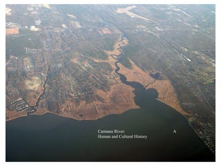
3. The Carmans River flows south through a gap in the Ronkonkoma moraine from
its headwaters located in the area of Artist Lake in Middle Island.
4. Only one Native American tribe lived on Long Island – the Algonquians. Throughout the
Island, they spoke the same language and shared cultural and religious beliefs. They were
the Long Island confederacy of the Delaware Indians. About 6,000-7,000 Algonquians lived
on Long Island in the 1600s when the first settlers arrived. They were known for making fine
wampum, the currency used by all Indians east of the Mississippi river.
5. About 1,000 BC, Long Island’s Algonquin people began using horticultural techniques, and small permanent
villages evolved across the Island, mainly along the shores. The main local village was along Unkechaug Creek
in today’s Shirley (where Tobaccus, who signed many of the land sales, was buried in 1700). It is said that one
of their meeting places was at today’s Indian Landing on the east side of Carmans River.
6. By 1700, most of the local Delaware-Algonquins – called Unkechaugs, those who lived between Bayport and
Eastport – were decimated by disease. Not understanding the white man’s idea of land ownership, they gave
away their land, as well as their right to hunt and fish on it, for mere trinkets. Like Natives elsewhere, most
turned to wage labor, mostly obtained by going to sea. They often married with Black slaves and thereby
sacrificed their legal freedom.
7. The Native Americans called it the Connecticut, meaning long river; the settlers called it the East
Connecticut, the West being today’s Connetquot River. In this 1797 map, which shows the inlet
that opened in 1772, the highlighted areas shows the land that was most valuable to the settlers,
that which was salt hay meadow.
8. In 1657, Narcomac
meadows was the
very first parcel of
land on the
Carmans River that
the white settlers in
Setauket bought
from the
Unkechaugs.
9. Nearly the whole upper
river, as well as about 2
miles of the west bank of
the lower river, was
purchased, first from the
Long Island Algonquin
sachem Wyandance in
1664, and again in 1671
from the local Algonquin
leader Tobaccus, who was
unhappy that he wasn’t
included in the original
deal. The last piece of the
river purchased was Map delineated
by John Deitz
Yaphank Neck in 1688.
10. The location for these photos is at the end of Beaver Dam Road. From about 1873 to 1905,
the land was owned by Joseph Carman, then by Carman Lush who sold the 50- foot wide
strip of land to the Town circa 1909. The Town then extended Beaver Dam Road to the
river. In 1917, James Post bought the 13 acres along the river to the south of the road
(Squassux Landing) from Mr. Lush, to quietly let the community use it for their boats.
All salt-haying photos courtesy of the
Post Morrow Foundation
11. Salt marsh meadows were precious to the early settlers because it was land
that they didn’t have to clear and cultivate to provide grazing for their cattle .
Salt hay, which initially bought the settlers down from Setauket, was also used
for insulation in housing and for ice houses in which winter ice was stacked
and where perishable food was stored.
12. All photos of salt haying in this presentation were
taken by artist Fredrick Kost circa 1900 and are part
of the Post Morrow Foundation’s collection.
13. Many of these photos were made into oil or watercolor
paintings by Fredrick Kost and are still in the
community. Mr. Kost lived at 298 Beaver Dam Road
until his death in 1923.
14. To regulate the taking of salt hay, the Town declared the
second Tuesday in September as “Marshing Day.” In this circa
1900 photo, Wallace Swezey (179 Old Stump Road) is shown
with his harvest.
15. Although feudalism had already been abolished by parliament in England, Long Island was still considered personal real estate of the sovereign and
considered the property of King William and Queen Mary. In 1687 Colonel William Smith purchased much the land outlined above and in 1693 was
granted a patent for the Manor of St George. The portion of this map from west of the Carmans River is inaccurate and not part of the Manor.
16. This photo of South Haven mill was taken before 1875. Probably built by Samuel Terrell circa
1740, it was located where Sunrise Highway is today and was in operation until 1910. The building
on the left was the planing, or saw mill, and the building on the right was the fulling (processing of
cloth from flax so that it thickened and shrunk) and grist mill. The mill was purchased by John
Havens in 1745 and later owned by the Carman family.The lumber mill was removed in 1875, when
Henry Carman sold the land it was on to the Suffolk Club.
Next three photos courtesy Post Morrow Foundation
17. T. R. Bayles, “Early Mills, Roads, and Industries in Brookhaven Town,” 1976: “The South Haven mill,
located just north of the ‘goin over’ of the Montauk highway, and was in operation in 1745, and contained
the large mill stones between which the grain was ground, until it was torn down by the extension of the
Sunrise highway in 1958. Water still poured through the mill race as it did before the Revolution, but the
mill wheels had long been silent. As with the Yaphank mills this was a grist and saw mill. Sam Carman
conducted a tavern and general store just to the west of the mill, and with the meeting house across the
road built in 1740, this was the center of life in this part of Brookhaven town in those years."
18. This picture of the mill, taken before 1875, is from the north side looking downriver. The Carman family, who also
owned the Tavern and general store just in front of the mill along South Country Road, was a shareholder in the
mill from 1780 to 1875. All photos of the Carmans mill courtesy of the Post Morrow Foundation
22. Simultaneous with the establishment of the mill in 1740 was the building of the second church in Brookhaven
Town, the Old South Haven Presbyterian Church, directly across from the mill on the banks of Carmans River.
23. In 1780, 40 years after the mill and church were built, the new owner of the mill, Sam Carman, built a tavern,
inn and general store directly in front of the mill, and South Haven became the Colonial center of the south
shore of Brookhaven.
24. Although the area
referred to as “the
plains” was part of
the “Old Purchase at
South” in 1664, it
wasn’t until 1720 that
the Town began
dividing the land into
lots in soon-to-be-
named Millville.
25. Beginning in 1740, a
community dependent upon
the mills for their livelihood
developed between the two
mills that lie along today’s
Main Street, as indicated on
this 1873 map.
There were several
Millvilles on Long Island,
and that caused postal
problems. So, in 1845, the
community was renamed
Yaphank, after the name of
the eastern boundary line.
Yaphank is a Native
American name meaning
“the bank of a river.”
26. Known as the Sweezey Mill or Upper Mill, the original Yaphank mill was built by Capt. Robert Robinson and was
in operation circa 1740. By 1815, the mill changed hands to the Christopher Sweezey family, who tore down the
original mill and replaced it with the saw mill shown above. This saw mill remained the family business until circa
1900. It burned down circa 1914. Photo courtesy of the Yaphank Historical Society.
27. Sweezey’s Mill, date of photo unknown
Photo courtesy of the Yaphank Historical Society.
32. The current upper lake dam, circa 1930.
Photo courtesy of the Yaphank Historical Society
33. In 1762, John Homan built a saw mill about a mile downstream of the Sweezey mill, and, in 1771, added a grist mill
to it. In 1821, the Homan family sold their mills to Robert Hawkins, who tore down the original mills and replaced
them with a larger saw mill. A decade later, Hawkins’ nephew, E. L. Gerard, took over his uncle’s mill, which he
operated until his death in 1899. Gerard’s children continued the operation for a while and, sometime before 1917,
sold it to the Suffolk Club. The mill burned down in 1919. Photo courtesy of the Yaphank Historical Society.
34. Gerard’s Mill, date unknown. Photo courtesy of the Yaphank Historical Society.
36. In 1792, Ebenezer Homan built a fulling mill about a mile north of the Sweezy Mill. This mill apparently
didn’t last very long, perhaps only 20 years. There are no known photos of it except of the above
remains. A fourth mill site, a saw mill, was built about half a mile below Gerard’s Mill but was
abandoned before long. Photo courtesy of the Yaphank Historical Society
39. This 1900 survey, filed in the
County Clerk’s office on
June 6, 1904, file number 29,
shows that the Tangier
Smiths owned the river
bottom and all uplands on
the east side of the river,
about 7,000 acres, from
Montauk Highway south to
the Atlantic Ocean.
40. In 1910 Fredrick J. Quinby created the Tangiers Development Corporation and
purchased nearly 7,000 acres along the east side of Carmans River, today’s
Shirley, from approximately Montauk Highway south to the Great South Bay.
41. Note Advertisement in Times Square
Fortunately for Carmans River, the Tangiers Development Company failed, and by
1917, the 7,000 acres had resorted back to the Tangier Smith family.
42. 250 years after Colonel
William Tangier Smith
purchased
approximately 10
square miles of
Brookhaven Town and
was granted a feudal
patent, the Tangier
Smith portion of the
Mastic peninsula
remained largely
undeveloped.
43. Currier and Ives’ depiction of Daniel Webster catching his famous 14-1/2 lb. trout in Carmans mill pond, circa 1821.
Sam Carman may not even have been the major shareholder in the mill, but he and his descendants became rich and
famous because of the businesses they ran from directly in front of the mill: a store, post office, tavern and Inn. All of
the “men of the day,” mostly members of the exclusive Suffolk Club, would come to hunt and fish at Carmans. The
Suffolk Club, whose members would include Martin Van Buren, August Belmont and Teddy Roosevelt, as well as
Webster, would lease the rights to Carmans River for 25 years at a time. In 1875, they bought approximately 1,200
acres from Henry Carman, mostly on the west side of the river, all the way from Yaphank down to the Great South
Bay. The Tangier Smiths still owned the east side of the river from Montauk Highway south to the bay.
44. Circa 1900, the Suffolk Club
began selling off some their
holdings along the southern
portion of the river.
45.
46. Circa 1920, Anson Hard,
stockbroker, member of the NY
Stock Exchange and Suffolk Club
member, bought the outstanding
shares from the remaining members
of the Suffolk Club and made it his
own personal hunting lodge for
himself and close friends.
Anson Hard, circa 1924
47. The Hard Estate was more
than 1,000 acres,
straddling 4 miles of
Carmans River all the way
from the Lower Lake in
Yaphank to the Montauk
branch of the LI Railroad
in South Haven.
48. Anson Hard’s home along the west bank of the river, near the
original site of the Suffolk Clubhouse, burned down in 1936.
49. The Hard home was rebuilt circa 1937 and is today’s Suffolk
County Parks Department headquarters.
50. The Hard Estate would also include all but two of the buildings shown
in this circa 1938 photo looking north over Montauk Highway. Not
shown in the above picture is the mill, which the dirt road goes to, as
shown in the following slide. The Carman Tavern was torn down in
1936 by Charles Robinson, and the lumber from it was used to build
some of his duck houses.
52. After Anson’s death in 1939, the estate
was left to his wife, Florence, and their
six children. When their youngest
child, Kenneth B., returned from the
navy after WWII, the family decided to
let him use the estate because he
wanted operate it as a game preserve.
Photo: Mrs. Florence Bourne
Hard with Kenneth B. and his
sister, Florence, 1927
53. Ken Hard grew up on the estate
and to him this was home.
54. In 1946, Ken Hard married Leona
Robinson, whose family owned the duck
farm across the street. Together they raised
four children on the Suffolk Lodge estate.
57. 1958 was the beginning of the end for Suffolk Lodge with the Sunrise Highway extension. A few years later, Suffolk
County condemned the rest of Ken Hard’s property, which became South Haven Park, the County’s first park.
62. The “going over” on South Country Road circa 1880.
This narrow point on the river is still there today, about
100 feet north of Montauk Highway.
63. Picture circa 1920. With the advent of the automobile, a better bridge was built about 100 feet south of
the original, where the current bridge is today.
64.
65. The first duck farms
appeared on the
Carmans River in
1921 along Little Neck
Run, thereafter to be
called “Runny Nose
Creek” by some locals.
66. ck
du n
t o
rs
Fi rms ans 921
fa rm in 1
Ca v e r
Ri
69. Robinson Duck Farm, South Haven, 1948. The Old South Haven Church in foreground is the last remnant of the
former Colonial center. In 1961, the church was moved 4 miles to the west. Photo courtesy of Ron Bush
70. Carmans River Duck Farm, aka Robinson’s Duck Farm. View looking north from the feed mill.
Photo by Ken Hard, 1949
72. The Robinsons duck farm was in operation from 1936 to circa 1980. During its most
productive years up to 10,000 Peking ducks a week were processed here.
Photo Ken Hard
73. In 1938, banker Maurice Wertheim purchased 1,700 acres straddling the lower Carmans River, most
from the Tangier Smith family, for his personal game preserve. In 1947. he deeded this land to the U.S.
Fish and Wildlife Service to become a wildlife Refuge upon his death. In 1974, some 600 additional acres
were added to the Refuge, including a 260-acre donation by the Wellington family and the purchase of
most of the land from Yaphank Creek west to Old Stump Road and south to the Carmans River,
including Little Neck Run and Yaphank Creek.
74. By 1917, all four mills in Yaphank were gone.
Roadways now cover over the original mill races
of both the Gerard and Sweezey mills.
75. During the late 1930s several camps
opened along the upper river, one of
which was infamous. Today the
former Camp Siegfried is a
Brookhaven Town park.
76. In 1900, Sam Newey
opened a ship building
yard near the mouth of the
river. Stephanie Bigelow
writes: “Captain Sam
Newey started to build
boats in 1900. Having sold
to the Vacuum Oil
Company a 65-foot
freighter he had built for
himself, he subsequently
built fourteen tankers
which went to India and
Africa. He built sloops,
yachts, yawls; boats for
ferrymen, boats for the oil
trade; and commercial
draggers equipped with
heavy booms….”
Dick Tooker bought the
boatyard in 1945 and ran it Pictured circa
until 1975, then sold it to 1940, Sam
Bill Starke, who operated it Newey (1865-
until 1999. The Post 1949) with
Morrow Foundation now local bayman
owns and operates a boat- Tom Poole
building school at the building eel
boatyard. pots.
77. Squassux Landing, circa 1900, as a cow pasture. This may have been owned by either the Suffolk Club or by Joseph
Carman at the time. This natural landing place near the mouth of the Carmans River has been used by both Native
Americans and Colonists for centuries. Early in the 20th century, as land along the river became privatized, many
locals, as well as a large New York City transient crowd bought on by the arrival of the railroad in 1881, Squassux
Landing was the best and only place to access the river. In 1917 James Post quietly brought the 13-acre site to let the
community use it as they wished. His heirs would deed the site to the Brookhaven Village Association in 1945.
81. For the past 63 years, Squassux Landing has been
used as a boatyard, park and fairgrounds for the
Brookhaven Hamlet community.
82.
83.
84. Cathedral Pines,
Headwaters of
Carmans River
Golf Course
Thanks to the efforts of Art Cooley
and the Bellport High School
students 40 years ago, much of the
land bordering the river has been
preserved, as will be shown in the
following photographs.
92. Former canoe rental
business; Brookhaven
Town in contract to
Sun
purchase.
rise
Hig
h
wa
y
ay
The
w
ove old “go
gh
r” in ’
Hi
uk
ta
n
Mo
93. dl e I sland
, Mid
R t 25
BNL
Flow rate= 2,500,000
gallons/day (Paul
Grosser, engineer) Yaphank
Flow rate = 15,600,000
LIE
gallons per day (USGS)
Flow rate = 35,000,000
gallons per day (USGS)
igh w ay Mastic
Sunrise H
Fire
Place
Bellport
Flow rate = 46,500,000
gallons per day (USGS)