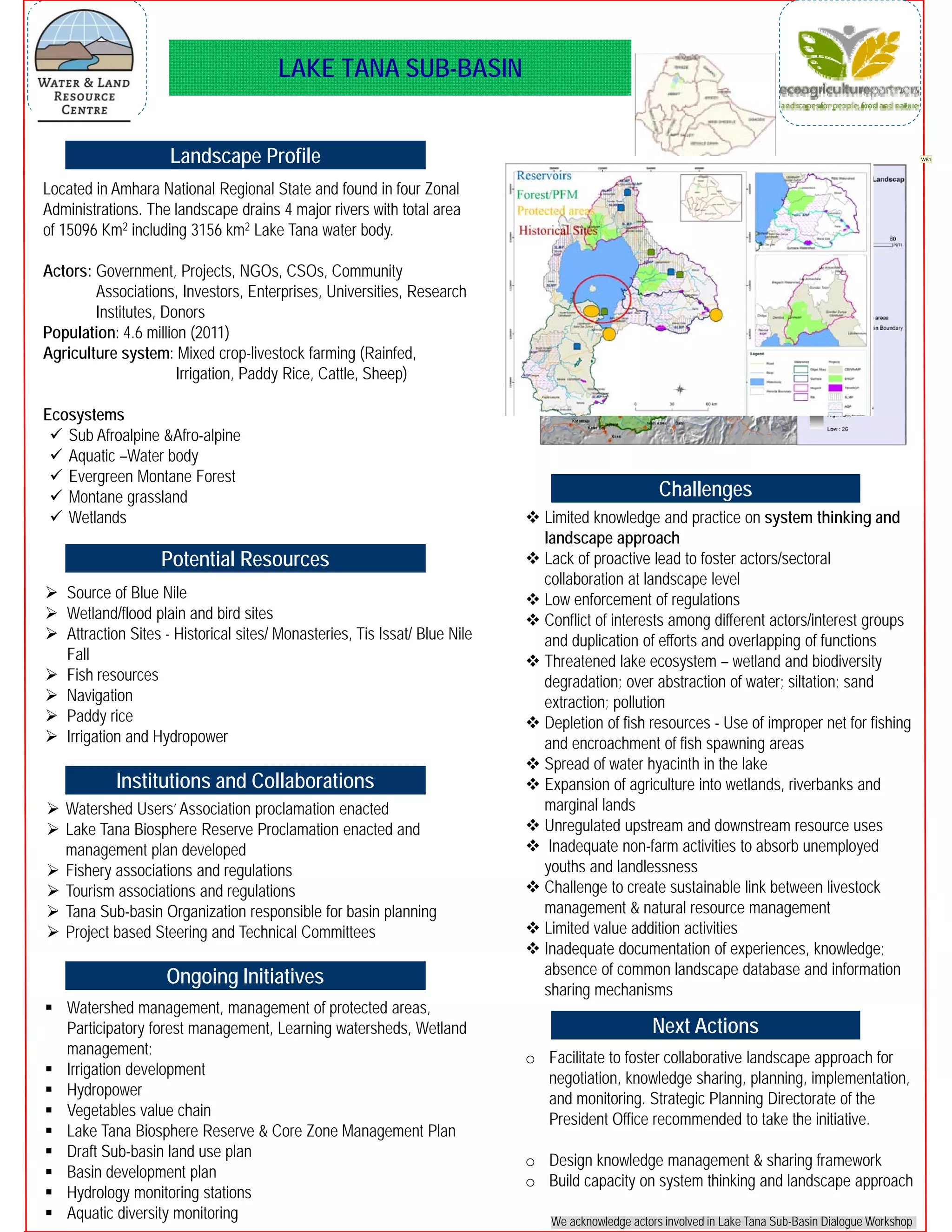
Landscape Profile
Ongoing Initiatives
Potential Resources
LAKE TANA SUB-BASIN
We acknowledge actors involved in Lake Tana Sub-Basin Dialogue Workshop
Located in Amhara National Regional State and found in four Zonal
Administrations. The landscape drains 4 major rivers with total area
of 15096 Km2 including 3156 km2 Lake Tana water body.
Actors: Government, Projects, NGOs, CSOs, Community
Associations, Investors, Enterprises, Universities, Research
Institutes, Donors
Population: 4.6 million (2011)
Agriculture system: Mixed crop-livestock farming (Rainfed,
Irrigation, Paddy Rice, Cattle, Sheep)
Ecosystems
 Sub Afroalpine &Afro-alpine
 Aquatic –Water body
 Evergreen Montane Forest
 Montane grassland
 Wetlands
 Source of Blue Nile
 Wetland/flood plain and bird sites
 Attraction Sites - Historical sites/ Monasteries, Tis Issat/ Blue Nile
Fall
 Fish resources
 Navigation
 Paddy rice
 Irrigation and Hydropower
 Watershed Users’ Association proclamation enacted
 Lake Tana Biosphere Reserve Proclamation enacted and
management plan developed
 Fishery associations and regulations
 Tourism associations and regulations
 Tana Sub-basin Organization responsible for basin planning
 Project based Steering and Technical Committees
 Limited knowledge and practice on system thinking and
landscape approach
 Lack of proactive lead to foster actors/sectoral
collaboration at landscape level
 Low enforcement of regulations
 Conflict of interests among different actors/interest groups
and duplication of efforts and overlapping of functions
 Threatened lake ecosystem – wetland and biodiversity
degradation; over abstraction of water; siltation; sand
extraction; pollution
 Depletion of fish resources - Use of improper net for fishing
and encroachment of fish spawning areas
 Spread of water hyacinth in the lake
 Expansion of agriculture into wetlands, riverbanks and
marginal lands
 Unregulated upstream and downstream resource uses
 Inadequate non-farm activities to absorb unemployed
youths and landlessness
 Challenge to create sustainable link between livestock
management & natural resource management
 Limited value addition activities
 Inadequate documentation of experiences, knowledge;
absence of common landscape database and information
sharing mechanisms
Institutions and Collaborations
 Watershed management, management of protected areas,
Participatory forest management, Learning watersheds, Wetland
management;
 Irrigation development
 Hydropower
 Vegetables value chain
 Lake Tana Biosphere Reserve & Core Zone Management Plan
 Draft Sub-basin land use plan
 Basin development plan
 Hydrology monitoring stations
 Aquatic diversity monitoring
Challenges
Next Actions
o Facilitate to foster collaborative landscape approach for
negotiation, knowledge sharing, planning, implementation,
and monitoring. Strategic Planning Directorate of the
President Office recommended to take the initiative.
o Design knowledge management & sharing framework
o Build capacity on system thinking and landscape approach
WB1
Slide 1
WB1 Better to put the
projects map
Wubneh Belete, 5/6/2015

Lake Tana Sub-basin, Ethiopia

  • 1.
    Landscape Profile Ongoing Initiatives PotentialResources LAKE TANA SUB-BASIN We acknowledge actors involved in Lake Tana Sub-Basin Dialogue Workshop Located in Amhara National Regional State and found in four Zonal Administrations. The landscape drains 4 major rivers with total area of 15096 Km2 including 3156 km2 Lake Tana water body. Actors: Government, Projects, NGOs, CSOs, Community Associations, Investors, Enterprises, Universities, Research Institutes, Donors Population: 4.6 million (2011) Agriculture system: Mixed crop-livestock farming (Rainfed, Irrigation, Paddy Rice, Cattle, Sheep) Ecosystems  Sub Afroalpine &Afro-alpine  Aquatic –Water body  Evergreen Montane Forest  Montane grassland  Wetlands  Source of Blue Nile  Wetland/flood plain and bird sites  Attraction Sites - Historical sites/ Monasteries, Tis Issat/ Blue Nile Fall  Fish resources  Navigation  Paddy rice  Irrigation and Hydropower  Watershed Users’ Association proclamation enacted  Lake Tana Biosphere Reserve Proclamation enacted and management plan developed  Fishery associations and regulations  Tourism associations and regulations  Tana Sub-basin Organization responsible for basin planning  Project based Steering and Technical Committees  Limited knowledge and practice on system thinking and landscape approach  Lack of proactive lead to foster actors/sectoral collaboration at landscape level  Low enforcement of regulations  Conflict of interests among different actors/interest groups and duplication of efforts and overlapping of functions  Threatened lake ecosystem – wetland and biodiversity degradation; over abstraction of water; siltation; sand extraction; pollution  Depletion of fish resources - Use of improper net for fishing and encroachment of fish spawning areas  Spread of water hyacinth in the lake  Expansion of agriculture into wetlands, riverbanks and marginal lands  Unregulated upstream and downstream resource uses  Inadequate non-farm activities to absorb unemployed youths and landlessness  Challenge to create sustainable link between livestock management & natural resource management  Limited value addition activities  Inadequate documentation of experiences, knowledge; absence of common landscape database and information sharing mechanisms Institutions and Collaborations  Watershed management, management of protected areas, Participatory forest management, Learning watersheds, Wetland management;  Irrigation development  Hydropower  Vegetables value chain  Lake Tana Biosphere Reserve & Core Zone Management Plan  Draft Sub-basin land use plan  Basin development plan  Hydrology monitoring stations  Aquatic diversity monitoring Challenges Next Actions o Facilitate to foster collaborative landscape approach for negotiation, knowledge sharing, planning, implementation, and monitoring. Strategic Planning Directorate of the President Office recommended to take the initiative. o Design knowledge management & sharing framework o Build capacity on system thinking and landscape approach WB1
  • 2.
    Slide 1 WB1 Betterto put the projects map Wubneh Belete, 5/6/2015