2. YELLOWSTONE NATIONAL PARK
DID YOU KNOW?
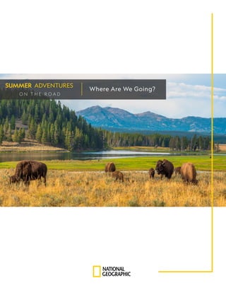
Yellowstone National Park, established in 1872,
is a 2,221,766-acre wilderness area maintained
by the National Park Service. It is located
at the intersection of Idaho, Montana, and
Wyoming, with the majority of its area in
Wyoming. The park is popular for its abundant
natural features, including calderas, geysers,
hot springs, and wildlife. It was the country’s
first national park, and it remains one of the
largest national parks in the United States.
Millions of people have visited the park to
take advantage of its hiking trails, scenic
views, glimpses of popular sites such as the
geyser called Old Faithful and one of the
largest hot springs in the United States, the
Grand Prismatic Spring, which is known for its
rainbow waters.
READY TO EXPLORE?
PG 3
Yellowstone Fun Facts
All Ages
PG 4
The Four Seasons
Ages 4-8
PG 6
Map the Park
Ages 4-8
PG 7
Peaks and Valleys
Ages 9+
PG 9
Plan your Visit
Ages 9+
Book List
3. YELLOWSTONE NATIONAL PARK
GEOLOGY
The geology of Yellowstone makes it unlike
any other place on Earth. Magma under
Earth’s crust is close to the surface, making
the region volcanically active.
The park includes three calderas, formed
from volcanic eruptions 2.1 million,
1.3 million, and 640,000 years ago,
respectively. Many features of the park
are a result of heat from the magma
transforming Earth’s surface.
BIODIVERSITY
Yellowstone also boasts a large variety of
animal and plant species. More than 1,000
species of native plants grow in the park.
Over 150 species of birds live in the park,
along with reptiles and fish, in a number of
distinct ecosystems.
Notably, the park contains a dense
mammal population, including herds of
bison and elk and large predators such as
wolves, grizzly bears, and mountain lions.
3
4. MATERIALS
Crayons or colored pencils
Device with internet connection (optional)
TO DO
Yellowstone National Park has four seasons, and each season brings a fresh look and feel to the
park’s environment. In this activity, make a Yellowstone drawing for the season labeled in each
box. Put at least one Yellowstone animal or feature in each drawing: a buffalo, wolf, fox, eagle,
geyser, mountain scene, or an animal or feature of your choice.
THINK ABOUT...
what colors to use to show each season in Yellowstone.
if the weather is cold, hot, or warm. How might you show that?
the time of day or night.
the kinds of trees and plants.
To get some ideas, view photographs of Yellowstone at the National Park Service. Which photos
show the four seasons? What do you see?
For more ideas, check out a book on Yellowstone at your local library.
THE FOUR SEASONS
ACTIVITY | Ages 4-8
4
6. MATERIALS
Device with internet connection
WATCH AND READ
Yellowstone National Park is one of the most visited parks in the world. For an overview of
the park, watch wildlife biologist Jeremy Schmidt explore the park and read this article from
National Geographic Kids.
TO DO
There is a lot to see in Yellowstone, and today on your virtual (or real!) visit, travel around
the park to see some of its sites and destinations. To get started, study this map then use
the entry points and destination on the chart to discuss what routes to take. Explore each
site and destination by clicking on the resource links. Enjoy your visit!
ENTRY POINT DESTINATION & LINKS
South Entrance Old Faithful
East Entrance Mammoth Hot Springs
Northeast Entrance Fishing Bridge
North Entrance Grant Village
West Entrance Tower Fall
SHARE
MAP THE PARK
ACTIVITY | Ages 4-8
6
Which sites would you like to visit?
What interests you about these sites?
7. MATERIALS
Device with internet connection
WATCH AND READ
Yellowstone National Park is diverse in many ways. Its landscape accommodates the needs
of a diverse group of animals and plants. Topographical maps reflect the types of earth and
elevations in an area. In this activity, read a topographical map to better understand the
valleys, peaks, and waterways inside the park.
When reading a topographical map, use the circular lines to understand elevations. To
learn more, watch How to Read a Topo Map.
TO DO
PEAKS AND VALLEYS
ACTIVITY | Ages 9+
What kinds of landforms do you see?
Where do you see peaks, valleys, and plains?
Can you tell if Yellowstone is above, below, or at sea level?
Are there any canyons?
Which is higher, Mt. Holmes or Joseph Peak?
Where would you find mountain sheep?
Where would you find bison?
What landforms do the roadways follow?
How would you describe the area around the lake?
Study this Yellowstone map. Contour lines indicate the shape of landforms, and the closer
together the lines are, the steeper or higher the elevation. The reference point is sea level.
If you took a hike in the park, what areas would you like to hike to?
How would you describe the topography of Yellowstone National Park to someone who
has never been there?
7
1
2
3
9. YELLOWSTONE SITES TO VISIT
9
PLAN YOUR VISIT
ACTIVITY | Ages 9+
MATERIALS
Device with internet connection
WATCH AND READ
Yellowstone National Park is one of the most visited national parks in the
United States. People from all over the world come to experience its grandeur.
But before you visit, whether in-person or virtually, you need a plan! Explore Yellowstone’s
destinations and decide which routes to take to visit them.
Read about park sites and destinations and select up to five you would like to visit. Then,
use the road map to decide what routes you would take to enter the park, get to the sites,
and exit the park.
TO DO
What highway entrance would you enter through if you were traveling from your home?
Which destination would you like to see first?
What are your second, third, fourth, and fifth stops?
At which entrance would you exit? Why?
Explore Plan Your Visit and Places to Go on the park website.
Choose five sites to visit and list them on the chart in any order.
Using the official map, decide in what order it makes the most sense to visit the sites. You
can use the “draw” feature to trace each route in a different color.
REFLECT
1
2
3
1
2
3
4
5
10. PG 2
Yellowstone National Park
https://www.nationalgeographic.org/encyclopedia/yellowstone/
PG 3
Calderas
https://www.nationalgeographic.org/article/types-calderas/?utm_source=BibblioRCM_Row
Bison
https://kids.nationalgeographic.com/animals/mammals/facts/american-bison
Wolves
https://kids.nationalgeographic.com/animals/mammals/facts/gray-wolf?source=partner_kids.aol.com
Grizzly bear
https://www.nationalgeographic.org/article/grizzly-bear-family/
Mountain lion
https://kids.nationalgeographic.com/animals/mammals/facts/mountain-lion
PG 4
National Park Service photos
https://www.nps.gov/yell/learn/photosmultimedia/photogallery.htm
PG 6
National Geographic video
https://www.nationalgeographic.org/video/yellowstone-first-national-park/?utm_source=BibblioRCM_Row
National Geographic Kids article
https://kids.nationalgeographic.com/nature/article/yellowstone
Yellowstone map
https://www.yellowstonepark.com/park/faqs/where-is-yellowstone-national-park/
Old Faithful
https://www.yellowstonepark.com/things-to-do/geysers-hot-springs/about-old-faithful/
Mammoth Hot Springs
https://www.yellowstonepark.com/things-to-do/geysers-hot-springs/mammoth-hots-springs-inside-cave/
Fishing Bridge
https://www.yellowstoneparknet.com/lake_village_area/fishing_bridge.php
Grant Village
https://www.nps.gov/yell/planyourvisit/westthumbgrantvillage.htm
Tower Fall
https://www.yellowstonepark.com/things-to-do/natural-wonders/tower-fall-beautiful/
PG 7
How to Read a Topo Map
https://www.youtube.com/watch?v=CoVcRxza8nI
Topographic map
https://yellowstone.net/maps/yellowstone-topo/
PG 10
Yellowstone Map
https://s3.amazonaws.com/pom-static-yellowstonepark/public/Yellowstone-official-road-map_2016-2.pdf
Plan Your Visit
https://www.nps.gov/yell/planyourvisit/index.htm
10
FULL LINKS