
Recommended
More Related Content
What's hot
What's hot (20)
Similar to Studying vertical profile of atmosphere
Similar to Studying vertical profile of atmosphere (20)
Recently uploaded
Recently uploaded (20)
Studying vertical profile of atmosphere
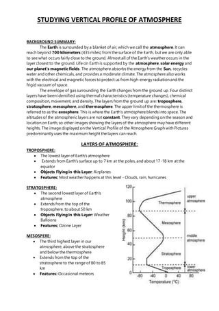
- 1. STUDYING VERTICAL PROFILE OF ATMOSPHERE BACKGROUND SUMMARY: The Earth is surrounded by a blanket of air, which we call the atmosphere. It can reach beyond 700 kilometers (435 miles) from the surface of the Earth, but we are only able to see what occurs fairly close to the ground. Almost all of the Earth’s weather occurs in the layer closest to the ground. Life on Earth is supported by the atmosphere, solar energy and our planet's magnetic fields. The atmosphere absorbs the energy from the Sun, recycles water and other chemicals, and provides a moderate climate. The atmosphere also works with the electrical and magnetic forces to protect us from high-energy radiation and the frigid vacuum of space. The envelope of gas surrounding the Earth changes from the ground up. Four distinct layers have been identified using thermal characteristics (temperature changes), chemical composition, movement, and density. The layers from the ground up are: troposphere, stratosphere, mesosphere, and thermosphere. The upper limit of the thermosphere is referred to as the exosphere. This is where the Earth’s atmosphere blends into space. The altitudes of the atmospheric layers are not constant. They vary depending on the season and location on Earth, so other images showing the layers of the atmosphere may have different heights. The image displayed on the Vertical Profile of the Atmosphere Graph with Pictures predominantly uses the maximum height the layers can reach. LAYERS OF ATMOSPHERE: TROPOSPHERE: The lowest layer of Earth's atmosphere Extends from Earth's surface up to 7 km at the poles, and about 17-18 km at the equator Objects Flying in this Layer: Airplanes Features: Most weather happens at this level - Clouds, rain, hurricanes STRATOSPHERE: The second lowest layer of Earth's atmosphere Extends from the top of the troposphere. to about 50 km Objects Flying in this Layer: Weather Balloons Features: Ozone Layer MESOSPERE: The third highest layer in our atmosphere, above the stratosphere and below the thermosphere Extends from the top of the stratosphere to the range of 80 to 85 km Features: Occasional meteors
- 2. THERMOSPERE: Outer layer of the atmosphere Extends from the top of the mesosphere to over 640 km The lower part of the thermosphere, from 80 to 550 km above the Earth's surface, contains the ionosphere Objects Orbiting in the Layer: Space Shuttle & International Space Station Features: Aurora EXOSPHERE: The highest layer of the atmosphere This layer often considered an extension of the thermosphere Extends from the top of the thermosphere up to 10,000 km The atmosphere here merges into space Objects Orbiting in this Layer: Satellites
- 3. STUDYING VERTICAL PROFILE OF ATMOSPHERE BY SATELITE: The conventional method for measuring the vertical profiles of the atmosphere is by the using the upper-air sounding system which regularly releases a weather balloon carrying a radiosonde 4 times every day (figure 1). Recently, meteorological centers have started using wind profilers and radiometers (figure 2) to enhance the upper-air observations. Such measurements are usually carried out in a sparse upper-air observation network due to high operating cost. To enhance the spatial coverage, polar orbiting meteorological satellites are now used to measure the vertical profiles of the atmosphere. Figure 1 AutomaticUpper-airSounding Figure 2 A windprofiler(left) andaradiometer(right) Systemcarryinga radiosonde How do polar-orbiting meteorological satellites measure the vertical profiles of the atmosphere? Some of the polar orbiting meteorological satellites, such as METOP and Feng-Yun 3, are equipped with instruments (such as IASI, AMSU-A and IRAS) for measuring the vertical profiles of the atmosphere. The vertical profiles that they can measure include temperature, moisture content, as well as concentration of trace gases. These instruments, including infrared sounders and microwave sounders, perform such measurements by remote sensing. How to measure the moisture content of the atmosphere by remote sensing? Various gaseous molecules in the atmosphere absorb electromagnetic waves at particular frequencies. Figure 3 shows the absorption spectrum of water vapors. Kirchhoff's law of thermal radiation states that the better an object is in absorbing electromagneticwave at a particular frequency; the more efficient it is in emitting electromagnetic wave at
- 4. that frequency thermally. Hence, the atmosphere also emits electromagnetic wave. By measuring the amount of electromagnetic wave emitted by the atmosphere with polar- orbiting meteorological satellites, the vertical profiles can thereby be calculated. How to measure temperature using infrared sounders? The hotter an object is, the more intense electromagneticwave will be emitted. This is Stefan-Boltzmann law. One example is the incandescent light bulb. The bulb will be brighter when it is hotter. How to measure the height of water vapors in the atmosphere? The vertical profile of the atmosphere can be obtained by taking measurements of the intensity of electromagnetic wave emittedby the atmosphere at multiple frequencies, as different frequencies can indicate the condition of the atmosphere at different heights. For example, if the measurement is taken at a frequency which is strongly absorbed by the atmosphere, the electromagnetic wave measured by the satellite will be mainly emitted from the top of the atmosphere. This is because the electromagnetic waveemitted near to the Earth's surface would be absorbed by the upper part of the atmosphere and ultimately cannot reach the satellite. On the other hand, if the measurement is taken at a frequency which is weakly absorbed by the atmosphere, satellite will then mainly measure the electromagneticwave emittednear the Earth's surface. This is because the density of air in the lower part of the atmosphere is much higher than that in the upper part of the atmosphere. Electromagnetic waveemitted near the Earth's surface still dominates in intensity even though it is partially absorbedby the upper part of the atmosphere. By measuring various frequencies, the satellite is able to "focus" on different heights of the atmosphere. The vertical profile is then the result of integrating pieces of information obtained at different heights.