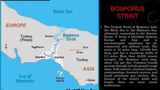
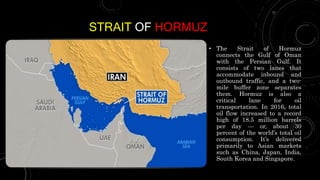
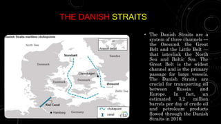
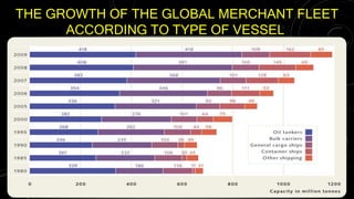
WORLD SEA
FREIGHT
MARKET
PRESENTED BY MONILKUMAR PARMAR
OVERVIEW
• What is the role of maritime transport improvements in globalization? We argue that the nineteenth century
is the ideal testing ground for this question: maritime freight rates fell on average by 50% while global trade
increased 400% from 1870 to 1913. We estimate the first indices of bilateral freight rates for the period and
directly incorporate these into a standard gravity model. We also take the endogeneity of bilateral trade and
freight rates seriously and propose an instrumental variables approach. The results are striking as we find
no evidence that the maritime transport revolution was the primary driver of the late nineteenth century
global trade boom. Rather, the most powerful forces driving the boom were those of income growth and
convergence.
• Over the last 50 years seaborne trade has seen a remarkable development. Shipping carries the vast majority
of international trade with its share ranging between 80 and 90 per cent of trade. This predominance is
particularly pronounced in developing countries where trade structures including the low volumes of
intraregional trade leave limited space for land transport and air transport. In terms of trade value, of
course, the shipping share is considerably lower with various estimates hovering around 60 to 70 per cent of
trade. Meanwhile, air transport, including express carriage, is on the rise, making considerable inroads in the
field of higher valued cargoes.
LIFE AT SEA
• Shipping, whether of cargo
or passengers, is a
business and the duties of
a ship's captain reflect
that. A captain's first duty
was to the ship's owner
and often the captain was
encouraged to buy into the
business with at least a
one eighth share of the
ship. A captain's second
duty was to the cargo itself
followed thirdly by the
crew.
MARITIME TRANSPORT
• Seven tenths of the earth are covered by water. Of the 510 million km2 making up the
planet's surface, 361 million km are oceans and seas. This is the main reason why
international trade is so intimately related to maritime transport, which moves the vast
majority of cargo. The volume of goods transported by sea rose from 550 million t of foreign
trade in 1950 to 2350 million t in 1970, and in 1979 reached the unprecedented figure of
3714 million t. It dropped sharply thereafter, due to the world recession, to 3090 million t
in 1983, and since then has recovered only to 3 362 million t in 1986.
FACTORS AFFECTING THE SHIPPING
BUSINESS
• A merchant marine is a creator of
collective wealth, whose contributions to a
country's economy go far beyond the
money earned from freights. It is a basic
instrument for a nation's development and
economic independence; an indispensable
and effective tool in the service of trade,
industry, production and consumption; an
activity that generates national income
and produces valuable foreign exchange;
an agent for regulating conference freight
rates; a source of direct and indirect
employment for individuals engaged in
transport operations and in related
activities such as provisioning, repairs and
shipbuilding, and a major client for
materials used in these activities.
FactorAffectingthe
ShippingBusiness
International
Conflicts
Harvests
Climate
Economic boom
or Recession
Other Factor
GROWTH THROUGH GLOBALIZATION
• Throughout history the oceans have been important to people around the world as a means of
transportation.
• Unlike a few decades ago, however, ships are now carrying goods rather than people. Since the rise
of intercontinental air travel, sea travel has become limited to shorter trips (ferry services across
the Baltic and North Seas, the Mediterranean, Japan and Southeast Asia) and recreational cruises.
The latter have recently experienced a tremendous boom and represent an increasingly lucrative
source of tourist income.
• As markets became increasingly globalized, shipping volumes soared. From the 1950s to the latest
global economic crisis, the growth rate of international trade was almost consistently twice that of
economic activity as a whole. From 2000 to 2008 world trade increased by an average 5.4 per cent
each year, while economic activity, as measured by the global Gross Domestic Product (GDP),
increased by only 3 per cent per annum.
• Due to the spectacular rise of trade vis-à-vis economic growth, world trade since the 1950s has
more than trebled to 45 per cent of the global GDP, while goods destined for the processing industry
have in fact more than quadrupled.
THE KEY SHIPPING ROUTES
• If all commercial goods are taken into account it becomes clear that there is a relatively
small number of principal transport routes, and these pass through only a few areas of the
oceans. The busiest are the approaches to the ports of Europe and East Asia, particularly
Japan but also Shanghai, Singapore and Hong Kong, and the United States.
• The East Coast of the United States in particular is a major sender and receiver of cargo.
Narrow straits further concentrate maritime traffic. Bottlenecks include the Straits of
Dover, Gibraltar, Malacca, Lombok and Hormuz, and the Cape of Good Hope at the
southern tip of Africa. Traffic builds up in these areas, making ships vulnerable to attack
by pirates.
• Natural and manmade water routes benefit international trade by providing quick sailing times and
an easier, cost-effective way to move goods. The eight routes give a glimpse into some of the busiest
and most popular shipping lanes for ocean cargo vessels.
Major World
Shipping Lanes
Strait of
Malacca
The English
Channel
Panama Canal Suez Canal
Bosphorus
Strait
Strait of
Hormuz
The Danish
Straits
Saint
Lawrence
Seaway
STRAIT OF
MALACCA
• The Malacca Strait is a narrow 550
miles and is the shortest route
between the Pacific and Indian
oceans. It links major Asian
economies such as India,
Indonesia, Malaysia, Singapore,
China, Japan, Taiwan and South
Korea. The Strait of Malacca is the
world’s second-busiest waterway,
with more than 83,000 vessels
traveling this route each year. In
2016, 16 million barrels of
oil flowed through the strait daily,
also making it a major oil
chokepoint. Other goods
transported through this strait
include coal, palm oil, Indonesian
coffee and liquefied natural gas.
THE ENGLISH
CHANNEL
• Known as the busiest shipping lane in the
world, the English Channel separates
England from France, and connects the
North Sea and the Atlantic Ocean. The
channel is 350 miles long, 20-150 miles wide,
and 150-400 feet deep. Approximately 500
ships travel the channel daily, making it a
critical route in the European shipping
network.
• Located at the narrowest part of the English
Channel is the Strait of Dover, which
connects the Baltic and the North Sea. More
than 400 vessels use this strait daily ,
carrying products like grain, minerals, steel
and oil.
PANAMA
CANAL
• The Panama Canal is an artificial
passageway designed to reduce transit
times between the Pacific and Atlantic
oceans. It’s approximately 50 miles long,
10 miles wide and takes roughly 10
hours to travel (tolls are required).
Before its completion in 1914, ships
would sail around Cape Horn at the
southern tip of South America —
increasing voyages by 2,000 to 8,000
nautical miles (or about 2,300 to 9,200
miles), depending on origin and
destination.
• In 2016, the Panama Canal expansion
opened to allow cargo ships carrying up
to 14,000 TEUs (twenty-foot equivalent
unit) to pass. Through a system of three
locks (the Mira Flores, the Pedro Miguel
and the Gatun), ships raise to the level of
Gatun Lake (85 feet above sea level) to
travel back to the Pacific Ocean. More
than 14,000 ships navigate the Panama
Canal each year, carrying vegetable oil
and fats, canned and refrigerated foods,
chemicals and petroleum chemicals,
lumber, machinery parts and grains.
SUEZ CANAL
• On November 17, 1869, the 120-mile
manually constructed Suez Canal
opened, creating the shortest maritime
route between the Atlantic and Indian
oceans. Without this route, vessels
would have to travel around Africa’s
Cape of Good Hope (transit times
typically lasting 24 days compared to
the canal’s 16 hours). Today, it’s
considered one of the world’s most
heavily used shipping lanes, with more
than 100 vessels traversing it daily. In
fact, 3.9 million oil barrels per day
transited the Suez Canal in 2016; and
in 2017, more than 900,000 tons of
cargo traveled through. Top
commodities transported are petroleum,
coal, metals, wood, oilseeds, cement and
fertilizers.
BOSPORUS
STRAIT
• The Turkish Strait of Bosporus links
the Black Sea to the Marmara Sea,
ultimately connecting to the Atlantic
Ocean. It forms a boundary between
Europe and Asia and is
internationally significant for oil,
commercial and military trade. The
strait is 19 miles long, 120-408 feet
deep, and has a maximum width of
2.3 miles. More than 48,000 vessels
navigate the Bosporus each year,
about 132 per day. Common vessels
passing through include general cargo
ships, bulk carriers, chemical tankers,
containerships, livestock carriers, and
liquid petroleum gas carriers. But,
because of the strait’s width and
length, there are some vessel
restrictions.
STRAIT OF HORMUZ
• The Strait of Hormuz
connects the Gulf of Oman
with the Persian Gulf. It
consists of two lanes that
accommodate inbound and
outbound traffic, and a two-
mile buffer zone separates
them. Hormuz is also a
critical lane for oil
transportation. In 2016, total
oil flow increased to a record
high of 18.5 million barrels
per day — or, about 30
percent of the world’s total oil
consumption. It’s delivered
primarily to Asian markets
such as China, Japan, India,
South Korea and Singapore.
THE DANISH STRAITS
• The Danish Straits are a
system of three channels —
the Oresund, the Great
Belt and the Little Belt —
that interlink the North
Sea and Baltic Sea. The
Great Belt is the widest
channel and is the primary
passage for large vessels.
The Danish Straits are
crucial for transporting oil
between Russia and
Europe. In fact, an
estimated 3.2 million
barrels per day of crude oil
and petroleum products
flowed through the Danish
Straits in 2016.
SAINT LAWRENCE SEAWAY
• Considered the most important
shipping lane in North America,
the St. Lawrence Seaway
connects the Atlantic Ocean with
the Great Lakes. Together, the
Great Lakes and St. Lawrence
River form the longest deep-draft
navigation system in the world.
It extends 2,300 miles into North
America and directly serves
Ontario, Quebec, Illinois,
Michigan, Ohio, Indiana,
Wisconsin, New York and
Pennsylvania. Every year, more
than 350,000 pounds of raw
materials, agricultural
commodities and manufactured
products travel this route. The
amount of products flowing
through make it a crucial
network for commerce between
the U.S., Canada and more than
59 overseas markets.
THE GROWTH OF THE GLOBAL MERCHANT FLEET
ACCORDING TO TYPE OF VESSEL
world sea freight market

world sea freight market

  • 1.
  • 2.
    OVERVIEW • What isthe role of maritime transport improvements in globalization? We argue that the nineteenth century is the ideal testing ground for this question: maritime freight rates fell on average by 50% while global trade increased 400% from 1870 to 1913. We estimate the first indices of bilateral freight rates for the period and directly incorporate these into a standard gravity model. We also take the endogeneity of bilateral trade and freight rates seriously and propose an instrumental variables approach. The results are striking as we find no evidence that the maritime transport revolution was the primary driver of the late nineteenth century global trade boom. Rather, the most powerful forces driving the boom were those of income growth and convergence. • Over the last 50 years seaborne trade has seen a remarkable development. Shipping carries the vast majority of international trade with its share ranging between 80 and 90 per cent of trade. This predominance is particularly pronounced in developing countries where trade structures including the low volumes of intraregional trade leave limited space for land transport and air transport. In terms of trade value, of course, the shipping share is considerably lower with various estimates hovering around 60 to 70 per cent of trade. Meanwhile, air transport, including express carriage, is on the rise, making considerable inroads in the field of higher valued cargoes.
  • 3.
    LIFE AT SEA •Shipping, whether of cargo or passengers, is a business and the duties of a ship's captain reflect that. A captain's first duty was to the ship's owner and often the captain was encouraged to buy into the business with at least a one eighth share of the ship. A captain's second duty was to the cargo itself followed thirdly by the crew.
  • 4.
    MARITIME TRANSPORT • Seventenths of the earth are covered by water. Of the 510 million km2 making up the planet's surface, 361 million km are oceans and seas. This is the main reason why international trade is so intimately related to maritime transport, which moves the vast majority of cargo. The volume of goods transported by sea rose from 550 million t of foreign trade in 1950 to 2350 million t in 1970, and in 1979 reached the unprecedented figure of 3714 million t. It dropped sharply thereafter, due to the world recession, to 3090 million t in 1983, and since then has recovered only to 3 362 million t in 1986.
  • 5.
    FACTORS AFFECTING THESHIPPING BUSINESS • A merchant marine is a creator of collective wealth, whose contributions to a country's economy go far beyond the money earned from freights. It is a basic instrument for a nation's development and economic independence; an indispensable and effective tool in the service of trade, industry, production and consumption; an activity that generates national income and produces valuable foreign exchange; an agent for regulating conference freight rates; a source of direct and indirect employment for individuals engaged in transport operations and in related activities such as provisioning, repairs and shipbuilding, and a major client for materials used in these activities. FactorAffectingthe ShippingBusiness International Conflicts Harvests Climate Economic boom or Recession Other Factor
  • 6.
    GROWTH THROUGH GLOBALIZATION •Throughout history the oceans have been important to people around the world as a means of transportation. • Unlike a few decades ago, however, ships are now carrying goods rather than people. Since the rise of intercontinental air travel, sea travel has become limited to shorter trips (ferry services across the Baltic and North Seas, the Mediterranean, Japan and Southeast Asia) and recreational cruises. The latter have recently experienced a tremendous boom and represent an increasingly lucrative source of tourist income. • As markets became increasingly globalized, shipping volumes soared. From the 1950s to the latest global economic crisis, the growth rate of international trade was almost consistently twice that of economic activity as a whole. From 2000 to 2008 world trade increased by an average 5.4 per cent each year, while economic activity, as measured by the global Gross Domestic Product (GDP), increased by only 3 per cent per annum. • Due to the spectacular rise of trade vis-à-vis economic growth, world trade since the 1950s has more than trebled to 45 per cent of the global GDP, while goods destined for the processing industry have in fact more than quadrupled.
  • 7.
    THE KEY SHIPPINGROUTES • If all commercial goods are taken into account it becomes clear that there is a relatively small number of principal transport routes, and these pass through only a few areas of the oceans. The busiest are the approaches to the ports of Europe and East Asia, particularly Japan but also Shanghai, Singapore and Hong Kong, and the United States. • The East Coast of the United States in particular is a major sender and receiver of cargo. Narrow straits further concentrate maritime traffic. Bottlenecks include the Straits of Dover, Gibraltar, Malacca, Lombok and Hormuz, and the Cape of Good Hope at the southern tip of Africa. Traffic builds up in these areas, making ships vulnerable to attack by pirates.
  • 8.
    • Natural andmanmade water routes benefit international trade by providing quick sailing times and an easier, cost-effective way to move goods. The eight routes give a glimpse into some of the busiest and most popular shipping lanes for ocean cargo vessels. Major World Shipping Lanes Strait of Malacca The English Channel Panama Canal Suez Canal Bosphorus Strait Strait of Hormuz The Danish Straits Saint Lawrence Seaway
  • 9.
    STRAIT OF MALACCA • TheMalacca Strait is a narrow 550 miles and is the shortest route between the Pacific and Indian oceans. It links major Asian economies such as India, Indonesia, Malaysia, Singapore, China, Japan, Taiwan and South Korea. The Strait of Malacca is the world’s second-busiest waterway, with more than 83,000 vessels traveling this route each year. In 2016, 16 million barrels of oil flowed through the strait daily, also making it a major oil chokepoint. Other goods transported through this strait include coal, palm oil, Indonesian coffee and liquefied natural gas.
  • 10.
    THE ENGLISH CHANNEL • Knownas the busiest shipping lane in the world, the English Channel separates England from France, and connects the North Sea and the Atlantic Ocean. The channel is 350 miles long, 20-150 miles wide, and 150-400 feet deep. Approximately 500 ships travel the channel daily, making it a critical route in the European shipping network. • Located at the narrowest part of the English Channel is the Strait of Dover, which connects the Baltic and the North Sea. More than 400 vessels use this strait daily , carrying products like grain, minerals, steel and oil.
  • 11.
    PANAMA CANAL • The PanamaCanal is an artificial passageway designed to reduce transit times between the Pacific and Atlantic oceans. It’s approximately 50 miles long, 10 miles wide and takes roughly 10 hours to travel (tolls are required). Before its completion in 1914, ships would sail around Cape Horn at the southern tip of South America — increasing voyages by 2,000 to 8,000 nautical miles (or about 2,300 to 9,200 miles), depending on origin and destination. • In 2016, the Panama Canal expansion opened to allow cargo ships carrying up to 14,000 TEUs (twenty-foot equivalent unit) to pass. Through a system of three locks (the Mira Flores, the Pedro Miguel and the Gatun), ships raise to the level of Gatun Lake (85 feet above sea level) to travel back to the Pacific Ocean. More than 14,000 ships navigate the Panama Canal each year, carrying vegetable oil and fats, canned and refrigerated foods, chemicals and petroleum chemicals, lumber, machinery parts and grains.
  • 12.
    SUEZ CANAL • OnNovember 17, 1869, the 120-mile manually constructed Suez Canal opened, creating the shortest maritime route between the Atlantic and Indian oceans. Without this route, vessels would have to travel around Africa’s Cape of Good Hope (transit times typically lasting 24 days compared to the canal’s 16 hours). Today, it’s considered one of the world’s most heavily used shipping lanes, with more than 100 vessels traversing it daily. In fact, 3.9 million oil barrels per day transited the Suez Canal in 2016; and in 2017, more than 900,000 tons of cargo traveled through. Top commodities transported are petroleum, coal, metals, wood, oilseeds, cement and fertilizers.
  • 13.
    BOSPORUS STRAIT • The TurkishStrait of Bosporus links the Black Sea to the Marmara Sea, ultimately connecting to the Atlantic Ocean. It forms a boundary between Europe and Asia and is internationally significant for oil, commercial and military trade. The strait is 19 miles long, 120-408 feet deep, and has a maximum width of 2.3 miles. More than 48,000 vessels navigate the Bosporus each year, about 132 per day. Common vessels passing through include general cargo ships, bulk carriers, chemical tankers, containerships, livestock carriers, and liquid petroleum gas carriers. But, because of the strait’s width and length, there are some vessel restrictions.
  • 14.
    STRAIT OF HORMUZ •The Strait of Hormuz connects the Gulf of Oman with the Persian Gulf. It consists of two lanes that accommodate inbound and outbound traffic, and a two- mile buffer zone separates them. Hormuz is also a critical lane for oil transportation. In 2016, total oil flow increased to a record high of 18.5 million barrels per day — or, about 30 percent of the world’s total oil consumption. It’s delivered primarily to Asian markets such as China, Japan, India, South Korea and Singapore.
  • 15.
    THE DANISH STRAITS •The Danish Straits are a system of three channels — the Oresund, the Great Belt and the Little Belt — that interlink the North Sea and Baltic Sea. The Great Belt is the widest channel and is the primary passage for large vessels. The Danish Straits are crucial for transporting oil between Russia and Europe. In fact, an estimated 3.2 million barrels per day of crude oil and petroleum products flowed through the Danish Straits in 2016.
  • 16.
    SAINT LAWRENCE SEAWAY •Considered the most important shipping lane in North America, the St. Lawrence Seaway connects the Atlantic Ocean with the Great Lakes. Together, the Great Lakes and St. Lawrence River form the longest deep-draft navigation system in the world. It extends 2,300 miles into North America and directly serves Ontario, Quebec, Illinois, Michigan, Ohio, Indiana, Wisconsin, New York and Pennsylvania. Every year, more than 350,000 pounds of raw materials, agricultural commodities and manufactured products travel this route. The amount of products flowing through make it a crucial network for commerce between the U.S., Canada and more than 59 overseas markets.
  • 17.
    THE GROWTH OFTHE GLOBAL MERCHANT FLEET ACCORDING TO TYPE OF VESSEL