ช่อง->choose the fieldin this layer that the Join will be based on : เลือก ADM_ID
ช่อง->choose the table to join to this layer,or load the table from disk : เลือก lutam
ช่อง->choose the field in the table to base the join on : เลือก ADM_ID
ช่อง->choose the fieldin this layer that the Join will be based on : เลือก AMP_ID
ช่อง->choose the table to join to this layer,or load the table from disk : เลือก luamp
ช่อง->choose the field in the table to base the join on : เลือก AMP_ID แล้ว กด -> Ok
คลิก luprv-> Open
16.
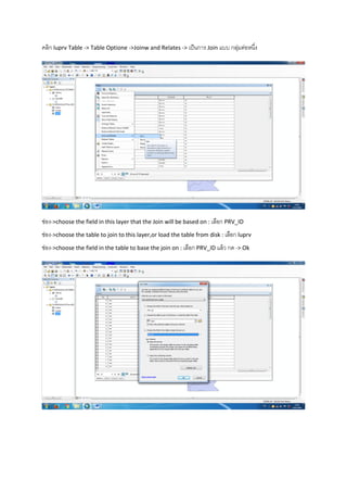
คลิก luprv Table-> Table Optione ->Joinw and Relates -> เป็นการ Join แบบ กลุ่มต่อหนึ่ง
ช่อง->choose the field in this layer that the Join will be based on : เลือก PRV_ID
ช่อง->choose the table to join to this layer,or load the table from disk : เลือก luprv
ช่อง->choose the field in the table to base the join on : เลือก PRV_ID แล้ว กด -> Ok
ช่อง->choose the fieldin this layer that the Join will be based on : เลือก LUCODE
ช่อง->choose the table to join to this layer,or load the table from disk : เลือก lucode
ช่อง->choose the field in the table to base the join on : เลือก LUCODE แล้ว กด -> Ok
ผลลัพธ์
27.
คลิก Geoprocessing ->Clip
ช่องInput features -> Land Use ช่อง Clip features ->Dam500 ช่อง Outpue features class->Saveชี่อที่
ต้องการ


![จะได้ตารางคานวณแบบนี้เราจะคานวณหา จานวนไร่ ด้วย [Area]/1600= แล้วจะได้จานวนไร่ออกมา
จะได้จานวนไร่ ดังนี้](https://image.slidesharecdn.com/random-160417071828/85/Vector-Model-37-320.jpg)