The document summarizes several landscape design projects by Sushmitha Sunder between 2015-2016, including:
1. A proposal for a wildlife preserve in the Kendall Creek Tract to protect red cockaded woodpeckers and recognize Creek Indian culture.
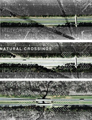
2. Documentation of the conditions along a 55 mile stretch of Interstate 85 and proposals to inform drivers of the ecologies present.
3. A thesis project exploring how to reimagine public spaces in a technological society by acknowledging new dynamics of interaction.
4. A design for Dudley Commons at Auburn University that demonstrates landscape ephemerality over 75 years through the growth of birch trees.