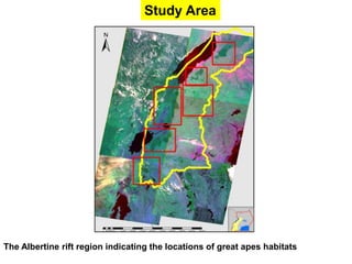
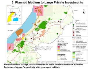
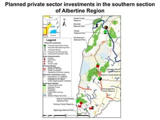
Mapping of Medium to Large Private Sector 
Investments and their Overlap with Great Apes’ 
Habitats in the Albertine Rift Region, Western 
Uganda 
Research findings presented by: 
Kyongera Denis (Makerere Univ.) 
BSc Conservation Biology (Honors) 
MSc in Zoology (Wildlife Option): 2013-2015 
September 2014
1. INTRODUCTION 
Of all the tropical rain forests in Uganda, it is only those in 
western part of the country that are habitats of great apes. 
This is because of the historical geographical connection of 
the great apes that inhabit the Congo Basin. 
The habitats of great apes have been under threat over 
many decades from different types of land uses, including 
medium to large scale private sector investments. 
However, there is scanty information regarding the 
relationship between medium to large scale private sector 
investments and their overlap with the great apes’ habitats 
which was the focus of my study.
2. Objectives 
The general objective was to: 
assess the likely factors (due to private investments) that 
would have the greatest future impacts on the habitats of 
great apes in Western Uganda in order to identify key 
areas for conservation focus. 
The specific objectives were to: 
1. identify and map the current extent of great apes’ 
habitats in the Albertine Rift Region, Western Uganda
Specific Objectives cont’ 
2. identify and map the existing and planned medium to 
large private sector investments, 
3. determine the overlap between the mapped private 
sector investments and great apes’ habitats in the 
Albertine Region to identify key areas of conservation 
concern.
Study Area 
The Albertine rift region indicating the locations of great apes habitats
3. STUDY APPROACH 
1. Current extent of great apes’ habitats: 
a) Acquired Landsat ETM+ satellite data of 2011 
b) Processed them (georeferencing, rectification and 
mosaicking) 
c) Acquired the 2002 Uganda land cover map produced by 
FAO and translated it’s legend to NFA classification 
legend 
d) Superimposed the FAO map onto the satellite imagery 
and reshaped the forest polygons to fit the current extent
Illustration 
Red lines show the previous extent of the forest habitat (FAO 2000), blue lines show the 
current extent of the forest habitat (leaf green); that were reshaped/resized in ArcGIS 
software ( on the left is a section of Budongo and on the right Kagombe Forest)
Study approach cont’d 
2. Location of medium to large private sector investments: 
a) Ground truthing was conducted using a GPS 
receiver/existing maps to correlate satellite image 
characteristics with large scale commercial plantations 
i.e. tea, broadleaved and coniferous plantations, sugar 
and rice. 
b) The information obtained was then used to interpret and 
classify Landsat ETM+ imagery acquired in 2011. 
c) Existing spatial information from different government 
agencies & private companies was also obtained and 
integrated with information derived from satellite images.
Study approach cont’d 
3. Mapping of planned medium to large private investments 
a) Information from the Uganda Investment Authority (UIA) 
about planned investments was obtained. 
b) The approximate position of these investments was 
established and then mapped based on the physical 
address. 
c) Additional information from PEPD , UNRA, UETCL was 
obtained and mapped. 
d) The planned investments were integrated with great 
apes’ habitat map to indicate the overlap(s).
4. FINDINGS 
General land cover/use types of the Albertine Rift Region: 
Land cover/use class Area in Km2 
Great apes habitat coverage 
(protected and non protected): 
1. Tropical high Forest 4,328 
1. Degraded Forest 1,443 
Sub total 5,771 
Large scale investments (crops): 
1. Sugar cane plantation 147 
1. Tea plantation 144 
1. Rice Plantation 59 
Subtotal 350 
Planted forestry: 
1. Broad Leaved Plantation 16 
1. Coniferous Plantation 76 
Subtotal 92 
Other land cover/use types: 48,548 
Grand Total 54,763
2. Existing Medium to Large Private Investments 
Budongo Forest Reserve in leaf green and 
sugar plantations in orange color 
Wambabya, Bugoma and Kasota Forest 
Reserves in leaf green, Sugar plantation 
in orange and tea plantations in Citroen 
Yellow
Existing Medium to Large Private Investments cont’d 
Semuliki, Mt. Rwenzori, and Kibale National Park, Kitechura, Ibambaro, and Matiri 
Forest Reserves in leaf green. Tea plantations in Citreon Yellow and rice plantations in 
Nubuck Tan, sugar plantations in Orange
Existing Medium to Large Private Investments Cont’d 
Kasyoha-Kitomi , Kalinzu/Maramagambo 
Forests Reserves in leaf green and tea 
Plantations in Citroen yellow 
Bwindi Impenetrable and Mgahinga 
National Park, Echuya Forest 
Reserve in leaf green. and 
coniferous plantation in pick
Existing agriculture investments and tourism 
infrastructure overlapping with great apes’ habitats 
Summary of the mapped 
Investments (point data) 
Type of Investment 
No. 
investments 
Agricultural enterprise 
Tea factories 18 
Cotton Ginneries 5 
Coffee factories 46 
Cocoa factory 1 
Dairy 22 
commercial farms 10 
Horticulture 2 
Saw Mills 10 
Research centrres 2 
Tree planting 1 
Irrigation sites 1 
Fish processing plants 14 
sub total 132 
Tourism Infrastructure 32 
Grand total 164
Existing mining companies overlapping with the habitats 
Mining: zoomed-in to a portion of 
the Albertine Region
Status of licensing of oil and gas companies in the 
Albertine Region
3. Planned Medium to Large Private Investments 
Planned medium to large private investments in the northern section of Albertine 
Region overlapping/in proximity with great apes’ habitats.
Planned private sector investments in the southern section 
of Albertine Region
Conclusions 
It is evident that the private sector investments overlap or 
are in close proximity with the great apes’ habitats. 
The overlap (hot spots) could be a threat to the great apes’ 
habitats. 
These hot spots could be a basis for conservation focus for 
the great apes in the Albertine Region.
Way Forward 
1. The next step is to ask for an extension of two months to 
allow me carry out ground truthing exercises regarding 
the accuracy of mapped medium to large scale private 
investments; and 
2. Prepare a final report.
End! 
Any Suggestion for improvement?

Mapping of Medium to Large Private Sector Investments and their Overlap with Great Apes’ Habitats in the Albertine Rift Region, Western Uganda

  • 1.
    Mapping of Mediumto Large Private Sector Investments and their Overlap with Great Apes’ Habitats in the Albertine Rift Region, Western Uganda Research findings presented by: Kyongera Denis (Makerere Univ.) BSc Conservation Biology (Honors) MSc in Zoology (Wildlife Option): 2013-2015 September 2014
  • 2.
    1. INTRODUCTION Ofall the tropical rain forests in Uganda, it is only those in western part of the country that are habitats of great apes. This is because of the historical geographical connection of the great apes that inhabit the Congo Basin. The habitats of great apes have been under threat over many decades from different types of land uses, including medium to large scale private sector investments. However, there is scanty information regarding the relationship between medium to large scale private sector investments and their overlap with the great apes’ habitats which was the focus of my study.
  • 3.
    2. Objectives Thegeneral objective was to: assess the likely factors (due to private investments) that would have the greatest future impacts on the habitats of great apes in Western Uganda in order to identify key areas for conservation focus. The specific objectives were to: 1. identify and map the current extent of great apes’ habitats in the Albertine Rift Region, Western Uganda
  • 4.
    Specific Objectives cont’ 2. identify and map the existing and planned medium to large private sector investments, 3. determine the overlap between the mapped private sector investments and great apes’ habitats in the Albertine Region to identify key areas of conservation concern.
  • 5.
    Study Area TheAlbertine rift region indicating the locations of great apes habitats
  • 6.
    3. STUDY APPROACH 1. Current extent of great apes’ habitats: a) Acquired Landsat ETM+ satellite data of 2011 b) Processed them (georeferencing, rectification and mosaicking) c) Acquired the 2002 Uganda land cover map produced by FAO and translated it’s legend to NFA classification legend d) Superimposed the FAO map onto the satellite imagery and reshaped the forest polygons to fit the current extent
  • 7.
    Illustration Red linesshow the previous extent of the forest habitat (FAO 2000), blue lines show the current extent of the forest habitat (leaf green); that were reshaped/resized in ArcGIS software ( on the left is a section of Budongo and on the right Kagombe Forest)
  • 8.
    Study approach cont’d 2. Location of medium to large private sector investments: a) Ground truthing was conducted using a GPS receiver/existing maps to correlate satellite image characteristics with large scale commercial plantations i.e. tea, broadleaved and coniferous plantations, sugar and rice. b) The information obtained was then used to interpret and classify Landsat ETM+ imagery acquired in 2011. c) Existing spatial information from different government agencies & private companies was also obtained and integrated with information derived from satellite images.
  • 9.
    Study approach cont’d 3. Mapping of planned medium to large private investments a) Information from the Uganda Investment Authority (UIA) about planned investments was obtained. b) The approximate position of these investments was established and then mapped based on the physical address. c) Additional information from PEPD , UNRA, UETCL was obtained and mapped. d) The planned investments were integrated with great apes’ habitat map to indicate the overlap(s).
  • 10.
    4. FINDINGS Generalland cover/use types of the Albertine Rift Region: Land cover/use class Area in Km2 Great apes habitat coverage (protected and non protected): 1. Tropical high Forest 4,328 1. Degraded Forest 1,443 Sub total 5,771 Large scale investments (crops): 1. Sugar cane plantation 147 1. Tea plantation 144 1. Rice Plantation 59 Subtotal 350 Planted forestry: 1. Broad Leaved Plantation 16 1. Coniferous Plantation 76 Subtotal 92 Other land cover/use types: 48,548 Grand Total 54,763
  • 11.
    2. Existing Mediumto Large Private Investments Budongo Forest Reserve in leaf green and sugar plantations in orange color Wambabya, Bugoma and Kasota Forest Reserves in leaf green, Sugar plantation in orange and tea plantations in Citroen Yellow
  • 12.
    Existing Medium toLarge Private Investments cont’d Semuliki, Mt. Rwenzori, and Kibale National Park, Kitechura, Ibambaro, and Matiri Forest Reserves in leaf green. Tea plantations in Citreon Yellow and rice plantations in Nubuck Tan, sugar plantations in Orange
  • 13.
    Existing Medium toLarge Private Investments Cont’d Kasyoha-Kitomi , Kalinzu/Maramagambo Forests Reserves in leaf green and tea Plantations in Citroen yellow Bwindi Impenetrable and Mgahinga National Park, Echuya Forest Reserve in leaf green. and coniferous plantation in pick
  • 14.
    Existing agriculture investmentsand tourism infrastructure overlapping with great apes’ habitats Summary of the mapped Investments (point data) Type of Investment No. investments Agricultural enterprise Tea factories 18 Cotton Ginneries 5 Coffee factories 46 Cocoa factory 1 Dairy 22 commercial farms 10 Horticulture 2 Saw Mills 10 Research centrres 2 Tree planting 1 Irrigation sites 1 Fish processing plants 14 sub total 132 Tourism Infrastructure 32 Grand total 164
  • 15.
    Existing mining companiesoverlapping with the habitats Mining: zoomed-in to a portion of the Albertine Region
  • 16.
    Status of licensingof oil and gas companies in the Albertine Region
  • 17.
    3. Planned Mediumto Large Private Investments Planned medium to large private investments in the northern section of Albertine Region overlapping/in proximity with great apes’ habitats.
  • 18.
    Planned private sectorinvestments in the southern section of Albertine Region
  • 19.
    Conclusions It isevident that the private sector investments overlap or are in close proximity with the great apes’ habitats. The overlap (hot spots) could be a threat to the great apes’ habitats. These hot spots could be a basis for conservation focus for the great apes in the Albertine Region.
  • 20.
    Way Forward 1.The next step is to ask for an extension of two months to allow me carry out ground truthing exercises regarding the accuracy of mapped medium to large scale private investments; and 2. Prepare a final report.
  • 21.
    End! Any Suggestionfor improvement?