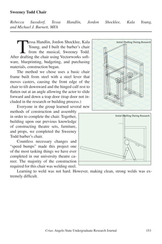
This study uses magnetic surveying and modeling to determine the geometry of a mafic sill intruded into Cretaceous limestone at Dagger Mountain in Big Bend National Park, Texas. Magnetic data was collected across the sill and modeled as either flat, folded, or ring dike shapes. The flat sill model provided the best fit to the observed magnetic data, suggesting the sill was emplaced after Laramide folding of the surrounding rock. This supports intrusion around 31 million years ago during Basin and Range extension rather than forceful emplacement during the Laramide orogeny as previously thought. Further geophysical surveys and radiometric dating are needed to fully understand the emplacement of sills


![Crius: Angelo State Undergraduate Research Journal 27
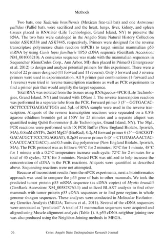
TABLE 1.− Primers designed from the mitochondrial cyt-b gene for the genus Eurycea
Water Collection and eDNA Extraction
Following the collection procedures set by Ficetola et al. (2008), water was col-
lected from Barton Springs Pool in Austin, Texas, which is home to the Barton Springs
Salamander (Eurycea sosorum) as a positive control. Water was taken from the Barton
Springs diving board (DB1 and DB2) and the deep end of the Barton Springs pool
(DEEP1 and DEEP2). For a negative control, water was collected from two tanks in
the Biology Department at Angelo State University. The first was Dr. Michael Dixon’s
office tank, which contained a Barred Tiger Salamander (Ambystoma mavortium) and
guppies (Poecilia reticulata) [DIXON1 and DIXON2]. The second was a tank in the
Angelo State zoology laboratory, which contained assorted native fish (Lepomis sps)
[ZOO1 and ZOO2]. The Barred Tiger Salamander and fish served as negative controls
because they are outside the genus Eurycea. Water was collected in 15 ml samples from
each location and labeled (Table 3). The water from the Devils River was collected in
two locations, one towards the north of the Southern Unit and one towards the south of
the Southern Unit. The northern sample (DRSNA-N) was collected by the “Take-Out
Point” (29°43’01.1” N, 101°01’18.4” W) and the southern sample (DRSNA-S) was
collected by the Summer House (29°41’02.0”N, 101°00’05.9”W). Immediately after
collection each sample was treated with 1.5 ml sodium acetate 3 M and 33 ml absolute
ethanol (Ficetola et al., 2008). Treated samples were then frozen at -20° C until DNA
extraction. For extraction, samples were centrifuged at 6° C at 5500 g for 35 min. Fol-
lowing this step, the supernatant was discarded and the pellet underwent a classical
DNA extraction using DNeasy Blood & Tissue Kit (Qiagen, Valencia, CA).
The products from the extraction were separated on a 0.8% agarose gel by elec-
trophoresis and analyzed, and this step was performed to verify the methods and to
compare concentrations of DNA collected from the tank samples to the Barton Springs
samples. Following electrophoresis, the samples were analyzed using a Qubit® fluo-
rometer (Life Technologies, CA) with a High Sensitivity (HS) assay to quantify the
concentration of DNA extracted.
Table 1
Primer Name DNA Sequence (5’-3’) Location on
gene (bp)
Euryc CytB Forward 3 CATACCTCAAAGCACCGAAGCAT 905-927
Euryc CytB Forward 7 AAAGCACCGAAGCATGTCATTTC 913-935
Euryc CytB Forward 10 ACCTCAAAGCACCGAAGCATGTC 908-930
Euryc CytB Reverse 7 TACCTGGCTGACCCCCAATTCAA 1007-991
Euryc CytB Reverse 10 CTTGGCTGACCCCCAATTCAAGT 1005-989
19](https://image.slidesharecdn.com/902895cb-b94c-4eaa-8444-679c63b7df6b-150723154015-lva1-app6891/85/Undergraduate-Research-Journal-30-320.jpg)


![Crius: Angelo State Undergraduate Research Journal 51
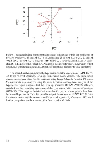
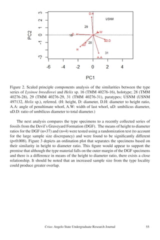
A re-examination of the fossil land snail Lysinoe breedlovei (Gastropoda: Pulmo-
nata) from west Texas using X-Ray Computed Tomography
Mary Jones and Ned Strenth, PhD
Abstract
This study examined fossil land snail specimens of Lysinoe breedlovei using High
Resolution X-Ray Computed Tomography. Specimens of the type series of Lysinoe
breedlovei from the Colmena Tuff (Vieja Group) at the mouth of Capote Creek, Presi-
dio County, Texas were analyzed. Analysis compared these fossils to recently collected
material from the Devil’s Graveyard Formation of Brewster County as well as a single
specimen from the Middle Oligocene sandstone of Nuevo Leon, Mexico. Results based
on multi-variate analysis support removal of the paratypic specimen TMM 40276-32,
the “Helix” sp. [sic] specimen from Nuevo Leon, as well as the recently collected
specimens from the Devil’s Graveyard from their current status within Lysinoe breed-
lovei. Pending further investigation, these specimens should be returned to their origi-
nal taxonomic assignments.
*****
R
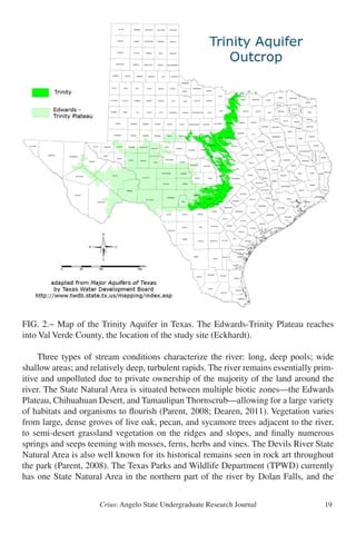
eports of large helicoid gastropod fossils from West Texas date back to the
1930s. Upon their initial discovery, most specimens were assigned to exist-
ing species from other regions of western North America. The first known
published record of fossil land snails in west Texas appears to be that of Henderson
(1935). He noted the presence of material from the O-2 Ranch, south of Alpine, which
he assigned to Helix? hesperarche [sic], an existing species described from the Eo-
cene of New Mexico by Cockerell (1914). Both Henderson and Cockerell (Henderson
1935) supported the similarity in morphology and matrix of the Texas material to that
of the type specimen of Helix hesperarche. However, Henderson (1935) addressed the
questionable assignment of the specimens as he stated that the group is “almost cer-
tainly not a true Helix” (1935: 134). J.A. Wilson et al. (1968) and Stevens et al. (1969)
noted and collected numerous fossil gastropods during early paleontological studies
in the Vieja Group of the Trans-Pecos region. Work by Pampe (1974) represents the
first major attempt at an overall coverage of the invertebrate fossil fauna of the Trans-
Pecos region of west Texas. Pampe (1974) examined and assigned those specimens
collected by Wilson to the existing species Helix leidyi, from the Eocene of Nebraska,
and Oreohelix grangeri from the Eocene of Wyoming. Roth (1984) then re-assigned
the material of Helix leidyi and Oreohelix grangeri as paratypes to his new species Ly-
sinoe breedlovei. He also referred material from additional collections from the Texas
Memorial Museum holdings as well as the Helix hesperarche material from the O-2](https://image.slidesharecdn.com/902895cb-b94c-4eaa-8444-679c63b7df6b-150723154015-lva1-app6891/85/Undergraduate-Research-Journal-54-320.jpg)


![Crius: Angelo State Undergraduate Research Journal62
self, development in this approach of AI might lead to computers that are able to find
answers to problems that human experts have not been able to solve.
Literature Review
There are several definitions of AI. One of the early challenges in AI was the Tur-
ing test. In this test, a human would communicate with a computer, and the computer
would respond. If the human could not tell if the response came from another human
or from a computer, the AI would be successful. In other words, if a computer was able
to imitate a human, it would be considered intelligent (Warwick, 1991). This approach
to AI assumes we can make a computer act (and perhaps think) humanly. However,
many people have tried to solve the Turing test without any great success. It turns out
a computer’s “brain” works very different than a human brain. A more modern ap-
proach to AI is to make a computer act rationally. Some scientists have defined this as
“[a] rational agent is one that acts so as to achieve the best outcome or, when there is
uncertainty, the best expected outcome” (Russell & Norvig, 2010, p. 4).
One of the most challenging and intriguing problems in artificial intelligence is
machine learning. How can we make a computer learn from previous iterations of
solving a task? It was not long ago that computers could not learn how to perform a
task by examples. Instead of learning from past mistakes, experts where required to
tell the computer how to act in every possible scenario of the task. Strides in machine
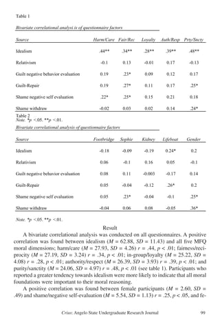
learning have made it possible for computers to solve complicated tasks without long
and exhausting pieces of hand-code (Anderson, 1986). One very interesting method to
achieve machine learning is combining genetic algorithms with artificial neural net-
works.
Artificial neural networks are inspired by the biological nervous system found in
a brain. They compute a value by feeding inputs through a system of connected per-
ceptrons (artificial neurons). Each input is multiplied with a connected weight before
they are added together and passed through a sigmoid function. The output of this sig-
moid perceptron is used as input for neurons in the next layer of the network (Azadeh,
Negahban & Moghaddam, 2012).](https://image.slidesharecdn.com/902895cb-b94c-4eaa-8444-679c63b7df6b-150723154015-lva1-app6891/85/Undergraduate-Research-Journal-65-320.jpg)


![Crius: Angelo State Undergraduate Research Journal 79
Sex and Gender Dimensions of Neglected Tropical Diseases in Women’s Health
in Sub-Saharan Africa
Sean Motl and David Sanders, PhD
Abstract
With over a billion people infected worldwide, neglected tropical diseases (NTDs)
are so named not just because of inadequate research and resources but also because
of the populations they infect. These are often the poorest of the poor, living on less
than US $2 a day. NTDs cripple the poor through social and economic oppression,
creating a vicious cycle of neglect. As a particularly vulnerable population, women
(both as a sex and as a gender) have distinct challenges. While these diseases have a
physical impact on a woman’s body, women’s roles and expectations within a society
can further exacerbate the burden of NTDs. With proposals focused on human rights,
the cycle of neglect can be broken through empowering women medically, politically,
economically, and socially. This project presents an analysis of the literature regarding
the relationship of women, poverty, and neglected tropical diseases.
*****
Introduction
G
lobally, one billion people are infected with neglected tropical diseases
(NTDs), killing approximately 534,000 people every year (Médecins Sans
Frontières [MSF], 2012). Mortality rates alone do not reflect the true bur-
den of these diseases. Increased risk of HIV/AIDS, blindness, stigma, and deformities
has devastating effects, perpetuating a cycle of neglect (Rilkoff, Tukahebwa, Fleming,
Leslie, & Cole, 2013). Composed of a variety of pathogens including bacteria, viruses,
protozoa, and helminthes, these diseases are so named not just because of inadequate
research and resources but also because of the population they infect, often the poorest
of the poor, living on less than US $2 a day (Hotez & Kamath, 2009). While this degree
of poverty can certainly exist in the city, this population is more commonly found in the
rural areas that have inadequate resources. Neglected tropical diseases (NTDs) act as a
clear demarcation between the rich and the poor, disproportionately affecting those in
poverty and suggesting a deeper injustice rooted in structural violence. These diseases
physically, politically, economically, and socially cripple the poor.
As a sub-set of this vulnerable population, women—both as a sex and as a gen-
der—have distinct challenges in the face of NTDs. While sex is a biological deter-
minant, gender is a social construct that develops and evolves over time (Vlassoff &
Moreno, 2002). Some of these diseases have particular, biological relevance to the sex](https://image.slidesharecdn.com/902895cb-b94c-4eaa-8444-679c63b7df6b-150723154015-lva1-app6891/85/Undergraduate-Research-Journal-82-320.jpg)
![Crius: Angelo State Undergraduate Research Journal80
of women. For example, lymphatic filariasis is often manifested in the breast or vulva
of women (Hotez, 2009), and certain drugs are unsafe when women are pregnant or
breastfeeding (Rilkoff et al., 2013). In addition to the biological factors, the roles and
expectations of women in society can compound their health outcomes, much like
social class (Vlassoff & Moreno, 2002). Women may be expected to suffer in silence
(Vlassoff & Moreno, 2002), to purchase bed nets for their entire household (Clemmons
et al., 2009), or to merely bear children (World Health Organization Regional Office
for Africa [WHO Africa], 2012). With these vulnerabilities in mind, medical interven-
tions can take a more defined and targeted approach. As men and women have different
social determinants of health, solutions for effectively eradicating neglected tropical
diseases in Sub-Saharan Africa (SSA) depend on a clear understanding and evaluation
of the risks and impact of gender inequalities.
Cycle of Neglect: Poverty and Disease
Appropriately, neglected tropical diseases are considered “neglected” for two ma-
jor reasons: (1) the majority of the population affected are vulnerable populations liv-
ing in conditions of poverty, and (2) research and development initiatives are relatively
underfunded and underdeveloped compared to more popular diseases. This creates a
vicious cycle of neglect. NTDs act as oppressive forces that prevent individuals from
obtaining higher social or economic statuses, constraining them to the conditions of
poverty. Meanwhile, the social and economic elements of poverty create a feedback
loop that allows NTDs to thrive.
As poverty is the leading cause of mortality and suffering, efforts in eradicating
NTDs must also contribute to the deracination of poverty. While eradicating NTDs
may relieve suffering, it does not treat the underlying, root problem. As these deaths
are concentrated within the lowest socioeconomic group, something must be said of
the larger context and system that is allowing these persistent injustices to occur. This
larger oppressive force is known as structural violence.
Poverty is often defined in terms of absolute or relative poverty lines, which largely
depend upon one’s income status. However, economic deprivation only represents a
portion of the definition. The United Nations defined poverty much more broadly. In
May 1998, the Administrative Committee on Coordination (ACC) issued the following
as part of a “Statement of Commitment for Action to Eradicate Poverty”:
ACC emphasizes that fundamentally, poverty is a denial of choices and
opportunities, it is a violation of human dignity. It means lack of basic capacity
to participate effectively in society. It means not having enough to feed and
clothe a family, not having a school or a clinic to go to, not having the land on
which to grow one’s food or a job to earn one’s living, nor having access to
credit. It means insecurity, powerlessness and exclusion of individuals, house-
holds and communities. It means susceptibility to violence and it often implies](https://image.slidesharecdn.com/902895cb-b94c-4eaa-8444-679c63b7df6b-150723154015-lva1-app6891/85/Undergraduate-Research-Journal-83-320.jpg)
![Crius: Angelo State Undergraduate Research Journal 81
living on marginal and fragile environments, not having access to clean
water and sanitation.
(Administrative Committee on Coordination [ACC], 1998)
TheACC is now known as the Chief Executives Board for Coordination, and it acts
as the principal coordinator for the United Nations with executive heads representing
every UN agency, organization, and fund. While this definition does contain connota-
tions of one’s economic status, the language also indicates a certain amount of social
oppression. In fact, it can be argued that this definition contains up to 13 different com-
ponents of poverty. However, definitions of words like “choice,” “dignity,” “powerless-
ness,” and “exclusion” remain almost impossible to operationalize.
Whether social or economic, all of these components are intricately intertwined
with neglected tropical diseases (NTDs). In fact, many of the conditions that define
poverty are the same conditions that place individuals at particular risk for contract-
ing NTDs, such as unclean water, poor hygiene, inadequate housing, lack of nutrition,
and weak immune systems (Gazzinelli et al., 2012). Of the one billion people who are
infected by NTDs, poverty is the common link between all of these infections, acting
as a sort of co-requisite for the existence of NTDs (Bergquist & Whittaker, 2012).
NTDs place a huge burden on the poor. The WHO and scholarly journals reference
the disability-adjusted life year (DALY), which is a tool to measure the overall burden
of disease. In its most simple form, one DALY is the equivalent to the loss of one year
of healthy life, which can be due to either disability or premature death (WHO, 2014).
In Sub-Saharan Africa, 8.6 to 21.2 million DALYs are lost annually due to NTDs (Ho-
tez & Kamath, 2009). Using data from the WHO’s Global Health Observatory Data
Repository (2013), Africa lost almost 13.5 times as many DALYs as North and South
America combined and over 1,000 times as many DALYs as Europe due to “tropical
diseases” in 2004. It is important to note that this category does not even include all
NTDs, as diseases such as trachoma and hookworm have their own category.
While it would be easy to assume that poverty is the cause of NTDs, the relation-
ship is far more complicated. Which came first, poverty or disease? Was it the condi-
tions of poverty, like poor sanitation and lack of clean drinking water, which caused
the disease? Or was it the symptoms of the disease, such as blindness or cognitive
impairment, which inhibited people from thriving and forced them into poverty? In
this sense, NTDs and poverty are best understood as correlational, not causal. While a
lower income may contribute to a greater rate of NTD infection, it is just as likely that
a greater rate of NTD infection may contribute to a lower income.
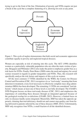
Figure 1 best simplifies the complexity of poverty and neglected tropical diseases,
as both seem to be defined and connected by social and/or economic oppression. The
cycle of neglect is similar to that of a circle: it has no beginning or end. Individuals
may enter into this cycle at any point and then continue in any direction. Accordingly,
individuals should be able to exit the cycle at any point. Trying to funnel one billion
people out of a single exit would take too much time, and too many people would die](https://image.slidesharecdn.com/902895cb-b94c-4eaa-8444-679c63b7df6b-150723154015-lva1-app6891/85/Undergraduate-Research-Journal-84-320.jpg)


![Crius: Angelo State Undergraduate Research Journal92
References
Administrative Committee on Coordination [ACC]. (1998). Statement of Commitment
for Action to Eradicate Poverty. Retrieved from http://unsceb.org/content/acc-
statement-commitment-action-eradicate-poverty-22-june-1998
Allen, T., & Parker, M. (2011). The ‘Other Diseases’ of the Millennium Development
Goals: rhetoric and reality of free drug distribution to cure the poor’s parasites.
Third World Quarterly 32(1): 91-117. doi: 0.1080/01436597.2011.543816
Bergquist, R., & Whittaker M. (2012). Control of neglected tropical diseases in Asia
Pacific: implications for health information priorities. Infectious Diseases of
Poverty 1(3). doi:10.1186/2049-9957-1-3
Binagwaho, A. (2012). Minister’s Vision. Republic of Rwanda Ministry of Health.
Retrieved from http://www.moh.gov.rw/index.php?id=49
Clemmons, L., Amazigo, U.V., Bissek, A.-C., Noma, M., Oyene, U., Ekpo, U.,...
Sékétéli, A. (2002). Gender issues in the community-directed treatment with
ivermectin (CDTI) of the African Programme for Onchocerciasis
Control (APOC). Annals of Tropical Medicine & Parasitology 96(1): 59-74. doi:
10.1179/000349802125000655
Centers for Disease Control and Prevention [CDC]. (2011). Neglected tropical
diseases: Other NTDs. Retrieved from http://www.cdc.gov/globalhealth/ntd/
diseases/ otherNTDs.html
Drugs for Neglected Diseases Initiative & Médecins Sans Frontières [DNDi & MSF].
(2012). Medical Innovation for Neglected Patients: Important Progress Over Past
TenYears,But“FatalImbalance”Persists.Retrievedfromhttp://www.msfaccess.org/
sites/default/files/ MSF_assets/Innovation/Docs/MedInno_Report_
MedInnforNegPatients_ENG_2012.pdf
Farmer, P. (2004). Pathologies of Power: Health, Human Rights, and the New War on
the Poor. Los Angeles: University of California Press.
Farmer P., Nizeye B., Stulac S., & Keshavjee S. (2006). Structural Violence and
Clinical Medicine. PLoS Med 3(10): e449. doi:10.1371/journal.pmed.0030449
Fongwa, M.N. (2002). International Health Care Perspectives: The Cameroon Example.
Journal of Transcultural Nursing 13(4): 325-330. doi:10.1177/104365902236708
Freeman, M.C., Ogden, S., Jacobson, J., Abbott, D., Addiss, D.G., Amnie, A.G.,
Utzinger, J. (2013). Integration of Water, Sanitation, and Hygiene for the Prevention
and Control of Neglected Tropical Diseases: A Rationale for Inter-Sectoral
Collaboration. PLoS NTD 7(9): e2439. doi:10.1371/journal.pntd.0002439
Gazzinelli, A., Correa-Oliveira, R., Yang, G.J., Boatin, B.A., Kloos, H. (2012). A
Research Agenda for Helminth Diseases of Humans: Social Ecology, Environmental
Determinants, and Health Systems. PLoS NTD 6(4): e1603. doi:10.1371/journal.
pntd.0001603
Hotez, P.J. (2009). Empowering Women and Improving Female Reproductive Health
through Control of Neglected Tropical Diseases. PLoS NTD 3(11): e559. doi:](https://image.slidesharecdn.com/902895cb-b94c-4eaa-8444-679c63b7df6b-150723154015-lva1-app6891/85/Undergraduate-Research-Journal-95-320.jpg)
![Crius: Angelo State Undergraduate Research Journal 93
10.1371/journal.pntd.0000559
Hotez, P.J., & Kamath A. (2009). Neglected Tropical Diseases in Sub-Saharan Africa:
Review of Their Prevalence, Distribution, and Disease Burden. PLoS NTD 3(8):
e412. doi:10.1371/journal.pntd.0000412
Hunt, P. (2007). Neglected diseases: A human rights analysis. Geneva: WHO
Kjetland, E.F., Leutscher, P.D.C., & Ndhlovu, P.D. (2012). A review of female genital
schistosomiasis. Trends in Parasitology 28(2): 58-65. doi:10.1016/j.pt.2011.10.008
Kleinman, A. (2010). Four social theories for global health. The Lancet 375(9725):
1518-1519. doi:10.1016/S0140-6736(10)60646-0
Mackey, T.K., & Liang, B.A. (2012). Global health policy coordination to address
neglected tropical diseases. Tropical Medicine and International Health 17(9):
1053-1056. doi:10.1111/j.1365-3156.2012.03049.x
Médecins Sans Frontières [MSF]. (2012). Fighting Neglect: Finding ways to manage
and control visceral leishmaniasis, human African trypanosomiasis and
Chagas disease. Retrieved from http://www.msf.org/shadomx/apps/fms/fmsdown
l o a d . c f m ? f i l e _ u u i d = D 7 5 5 3 4 1 5 - 1 8 A 9 - 4 A 4 4 - A D 6 2
F70397DD583E&siteName=msf
Moran, M. (2011). Global Funding of New Products for Neglected Tropical Diseases.
In: Institute of Medicine (US) Forum on Microbial Threats. The Causes and
Impacts of Neglected Tropical and Zoonotic Diseases: Opportunities for Integrated
Intervention Strategies. Washington DC: National Academies Press. Available
from: http://www.ncbi.nlm.nih.gov/books/NBK62528/
Ottesen, E.A. (2006). Lymphatic Filariasis: Treatment, Control, and Elimination. In
D.H. Molyneux (Ed.), Advances in Parasitology: Vol. 61. Control of Human
Parasitic Diseases. (pp. 395-441). Oxford, UK: Academic Press.
Rilkoff, H., Tukahebwa, E.M., Fleming, F.M., Leslie, J., & Cole, D.C. (2013).
Exploring Gender Dimensions of Treatment Programmes for Neglected Tropical
Diseases in Uganda. PLoS NTD 7(7): e2312. doi:10.1371/journal.pntd.0002312
United Nations International Children’s Emergency Fund [UNICEF]. (2014). Basic
education and gender equality: Girls’ education and gender equality. Retrieved
from http://www.unicef.org/education/bege_70640.html
United States Agency for International Development’s Neglected Tropical Disease
Program [USAID]. (2012). Targeted Diseases. Retrieved from http://www.neglect
eddiseases.gov /target_diseases/index.html
Vlassoff, C., & Moreno, C.G. (2002). Placing gender at the centre of health
programming: challenges and limitations. Social Science & Medicine 54(11):
1713-1723.
World Health Organization [WHO]. (2014). Health statistics and information systems:
Metrics: Disability-Adjusted Life Year (DALY). Retrieved from http://www.who.
int/healthinfo/ global_burden_disease/metrics_daly/en/
World Health Organization [WHO]. (2013). Global Health Observatory Data
Repository: No frills DALYs (no discounting, no age weights), 2004: DALYs.](https://image.slidesharecdn.com/902895cb-b94c-4eaa-8444-679c63b7df6b-150723154015-lva1-app6891/85/Undergraduate-Research-Journal-96-320.jpg)
![Crius: Angelo State Undergraduate Research Journal94
Retrieved from http://apps.who.int/gho/data/node.main.949?lang=en
World Health Organization Department of Control of Neglected Tropical Diseases
[WHO NTD]. (2013). Sustaining the drive to overcome the global impact of
neglected tropical diseases: Second WHO report on neglected tropical diseases.
David WT Crompton (Ed.). (WHO reference number: WHO/HTM/NTD/2013.1).
Retrieved from http://www.who.int/neglected_diseases/9789241564540/en/
World Health Organization Regional Office for Africa [WHO Africa]. (2014). Atlas
of African Health Statistics 2014: Health situation analysis of the African Region.
Retrieved from http://www.aho.afro.who.int/profiles_information/images/ a/ab/
AFRO-Statistical_Factsheet.pdf
World Health Organization Regional Office for Africa [WHO Africa]. (2012).
Addressing the Challenge of Women’s Health in Africa: Report of the Commission
on Women’s Health in the African Region. Retrieved from http://www.afro.who.
int/en/clusters-a-programmes/frh/gender-womens-health-a-ageing/
highlights/3741-addressing-the-challenge-of-womens-health-in-africa.html](https://image.slidesharecdn.com/902895cb-b94c-4eaa-8444-679c63b7df6b-150723154015-lva1-app6891/85/Undergraduate-Research-Journal-97-320.jpg)

![Crius: Angelo State Undergraduate Research Journal 101
tify the various moral foundations that underlie what Haidt hypothesizes are intuitive
affective appraisals of moral situations, so it might be argued that moral relativism is
a sort of ‘intuitive override’ in deference to a more non-committal moral stance. How-
ever, participants who were more relativistic in their ethical reasoning indicated no
greater need for cognition.
Since idealists, like conservatives, are positively correlated with all MFQ dimen-
sions, there may be a relationship between conservatism and an ideological belief in
moral absolutes. Relativism showed a strong negative correlation with age. Whether
or not this relationship can be generalized to a larger population cannot be presently
determined.
Guilt and Shame
Three of the four guilt and shame subscales (Guilt/ negative behavior evaluation,
guilt/repair, and shame/negative self-evaluation) were positively correlated with the
fairness/reciprocity moral dimension. Furthermore, shame/negative self-evaluation
was positively correlated with the harm/care moral foundation. Haidt and his fellow
researchers (2009) correctly hypothesized that these two moral dimensions would be
most strongly related to liberal ideologies. These findings could suggest that those who
align themselves with the political left are more prone to developing feelings of shame
for perceived moral shortcomings.
Machiavellian Personalities
The MPS had a significant positive correlation with the NFC score. Although not
significant, idealism seemed to be moving in the opposite direction, indicating a pos-
sible negative correlation with a need for cognition. Further research might investi-
gate this possible positive relationship between Machiavellianism and cognition. A
possibility exists that greater cognitive exertion is required for moral flexibility, as a
universal absolutist ethical system remains mostly constant, requiring less [dialectical
reasoning]. Possible research could study the relationship between Machiavellianism
and intelligence, to determine if there is a greater prevalence of this personality type
amongst those with higher IQs.
Gender
Female participants were positively correlated with both shame subscales. As the
GASP is designed to identify traits rather, this might further indicate a gap in gender-
role self-assessment and shame formation (Brody & Hall, 2008; Ferguson & Crowley,
1997; Ferguson & Eyre, 2000; Roberts & Goldenberg, 2007; Tracy & Robins, 2007b).
Limitations
Certain limitations of design and data collection should be mentioned. All of the
data collected within this study came from self-report questionnaires. Although these](https://image.slidesharecdn.com/902895cb-b94c-4eaa-8444-679c63b7df6b-150723154015-lva1-app6891/85/Undergraduate-Research-Journal-104-320.jpg)


![Crius: Angelo State Undergraduate Research Journal124
women were incapable of displaying the same intellectual skills or accomplishing the
same scholarly feats as a man was accepted by the majority of Victorian citizens as a
simple fact of life. Mary Ann Evans, a female feminist author who penned her works in
the nineteenth century under a male pseudonym, George Eliot, illustrates this attitude
in her novel entitled The Mill on the Floss. In this novel, brother and sister Maggie and
Tom argue about whether or not Maggie would be capable of learning the same sub-
jects Tom has been learning from his new tutor, Mr. Stelling. Mr. Stelling settles their
argument by declaring, “They’ve [girls] a great deal of superficial cleverness; but they
couldn’t go far into anything. They’re quick and shallow” (Eliot 140). Maggie, who
always prided herself on being a rather clever little girl, is crushed by his conclusion.
However, his words are only a reflection of the generally accepted social conventions
surrounding female intellectuality at this time. Society accepted women as being frivo-
lous, shallow, and intellectually deficient creatures.
This theory of female insufficiency was actually based on what was thought of as
concrete, scientific evidence. John Stuart Mill acknowledges this supposed evidence
as well in his essay “The Subjection of Women.” He states, “But (it is said) there is
anatomical evidence of the superior mental capacity of men compared with women:
they have a larger brain” (Mill 190). Scientific examinations of the human body re-
vealed that, overall, men possessed bigger brains than females. Upon this discovery,
researchers came to the conclusion that men must therefore hold superior capacity for
intellectual pursuit and the storage of knowledge. This conclusion then bred the belief
that men were more capable of rational, logical thought and therefore more suitable for
professional pursuits than women.
Thus, the male dominated Victorian society actually possessed scientific evidence
to further reinforce their power over the supposed weaker sex. Not only were women
held in a different class from men socially and politically, but they were also now clas-
sified as lesser beings scientifically. As a result, girls, upon their very first breath in the
world, were viewed differently by society than their male counterparts. A woman’s
image and purpose within society was influenced directly by her overall proven inferi-
ority to the men in her life. John Ruskin, an Oxford professor who published scholarly
discourses on all subjects ranging from scientific theory to politics to economics as
well as social discourse, discusses the differences between men and women in his es-
say “Of Queen’s Gardens.” He believed that men and women, due to their vast differ-
ences in intellectual and physical abilities, fulfilled vastly different functions in life. He
argues,
Man’s power is active, progressive, defensive. He is eminently the
doer, the creator, the discoverer, the defender. His intellect is for
speculation and invention; his energy for adventure, for war, conquest
necessary. But the woman’s power is for rule, not for battle,—and her
intellect is not for invention or creation, but for sweet ordering,
arrangement and decision . . . Her great function is Praise. (Ruskin 115)](https://image.slidesharecdn.com/902895cb-b94c-4eaa-8444-679c63b7df6b-150723154015-lva1-app6891/85/Undergraduate-Research-Journal-127-320.jpg)


![Crius: Angelo State Undergraduate Research Journal132
woman would generally be expected to give these infants up to the care of a nurse or
governess. She was expected to serve the role of their mother. However, a mother in
the Victorian Age was someone largely not involved in the day to day dirty process of
childrearing. Perkins records the words of a Victorian woman stating, “Mary Lutyens
wrote, ‘Nanny was my life . . . Mother was a goddess. It was unthinkable that a god-
dess should bathe me’”(15). Women were expected to serve as the vehicle for their
children’s births, and then they were expected to serve as a distant example of tender,
moral guidance for their little children. In fact, small children were largely confined in
Victorian households to an entirely separate wing away from their mother or the adults
of the house, so as not to intrude upon the adults’lives (Perkin 13). A woman was sepa-
rated from her children’s work and their play until they became of a more appropriate
age to join the adult world which she and their father occupied.
In addition to simply performing the various duties of a wife and a mother, a wom-
an was also expected to exude certain feminine qualities and characteristics as she
served these roles. For example, a woman was generally not encouraged to think about
her own desires or well-being in life but was instead encouraged to be inherently self-
less and subservient to others. As a wife, she was expected to defer all of her comfort
for the good of her husband’s comfort. As a mother, she was expected to defer her de-
sires for the good of her children. Sarah Stickney Ellis commends this attitude of total
self-sacrifice by stating,
She [A woman] does not meet him upon equal terms. Her part is
to make sacrifices, in order that his enjoyment may be enhanced.
She does this with a willing spirit; but from error of judgment, or
want of adequate result, and so often without grateful
acknowledgement. (138)
The most disturbing part of this passage is the “willing spirit” with which these women
were expected to give up all self-advancement or fulfillment. Women were taught to
part with their own desires or joys in this world when another’s crossed them. Even the
personal time she held when she was not performing her domestic duties was not her
own. Cassandra Nightingale laments,
Women were never supposed to have any occupation of sufficient
importance not to be interrupted, except “suckling their fools;” and
women themselves have accepted this, have written books to support
it, and have trained themselves so as to consider whatever they do as
not of such value to the world or to others, but that they can throw it
up at the first “claim of social life.” (32)
Women were trained to believe that none of their pursuits in this world could possi-
bly be of any worth. Their intellect was inferior; therefore they had nothing useful or](https://image.slidesharecdn.com/902895cb-b94c-4eaa-8444-679c63b7df6b-150723154015-lva1-app6891/85/Undergraduate-Research-Journal-135-320.jpg)
![Crius: Angelo State Undergraduate Research Journal 137
In 1796, Philipp Grimm died from pneumonia. His death was severely traumatic
for the whole family, but especially so for Jacob and Wilhelm. Jacob assumed the du-
ties of the head of the family, and the responsibility of the family’s well-being settled
upon both Jacob and Wilhelm. The family quickly became totally dependent upon the
help of the grandfather, Johannes Hermann Zimmer, and the maternal aunt, Henriette
Zimmer.
By 1798, Henriette had arranged for Jacob and Wilhelm to study at the prestigious
Lyzeum in Kassel1
, and both boys felt great pressure to succeed in their studies. Just as
the boys were entering the Lyzeum, their grandfather passed away, and they were left
without a guiding father figure. This brought the brothers closer together, and they de-
voted more than twelve hours a day to their studies. Both graduated from the Lyzeum
at the top of their class, Jacob in 1802 and Wilhelm in 1803, and they would go on to
study law at the University of Marburg.
Jacob applied the same industry and devotion to his studies at the University of
Marburg as he had at the Lyzeum in Kassel, and, by the time Wilhelm arrived, Ja-
cob’s excellent performance had drawn the attention of Professor Friedrich Carl von
Savigny, who would profoundly influence the Grimms’ belief system. Savigny was the
founder of the historical school of law, and he argued that the spirit of a law could only
be understood by tracing its historical context to the development of the customs and
language of the people to which it belonged. The Grimms used this approach to show
the German people, through literature, that they shared a common culture. Savigny
also introduced the brothers to the poets Clemens Brentano and Achim von Arnim.
Both Brentano and Achim von Arnim had been influenced by the works of Johann
Georg Hamann and Johann Gottfried Herder, which “called for a rediscovery of Volks-
poesie [folk poetry], the natural and genuine literature of the people” (Zipes 8).
In 1805, Savigny invited Jacob to accompany him on a research endeavor in Par-
is. While there, Jacob collected documents and materials related to German customs,
laws, and literature. He expressed to Wilhelm how he felt more drawn to the study of
Old High German and Germanic literatures than anything else, and, upon returning to
Germany in 1806, Jacob decided to abandon the study of law in pursuit of literature.
Wilhelm remained in Marburg to finish his law studies.
Collection and Publication of the Tales
It was during this time period that Jacob and Wilhelm also began gathering folk
tales systematically. In 1805, Achim von Arnim and Clemens Brentano had published
the first volume of Des Knaben Wunderhorn (The Boy’s Magic Horn), which was a
collection of old German folk songs. Brentano wanted to continue his folklore endeav-
ors by expanding into folk tales, so he enlisted the help of Jacob and Wilhelm, who
gathered tales from old books and began recruiting friends and acquaintances to record
tales on their behalf.
Savigny granted Jacob and Wilhelm access to his vast personal library for both](https://image.slidesharecdn.com/902895cb-b94c-4eaa-8444-679c63b7df6b-150723154015-lva1-app6891/85/Undergraduate-Research-Journal-140-320.jpg)


![Crius: Angelo State Undergraduate Research Journal 163
The Labour Reserve Army in Karl Marx’s Das Kapital, Vol. 1
Jarred A. Luján and John Glassford, PhD
Abstract
In a world still reeling from the economic crisis of 2008, many questions regarding
our market system forcefully arose back into discussion. Philosopher Karl Marx was
the originator of many of these questions over a hundred years ago. Marx has a well-
known position that stands against capitalism’s existence that is justified by a multitude
of deep analysis and complex arguments. However, this project aimed to look at one
specific part of Marx’s criticisms that is a very prominent issue today: unemployment
(what Marx called the Labour Reserve Army.) With this in mind, we analyzed Karl
Marx’s masterpiece: Das Kapital, Vol. 1 to see how he explains the problem that the
unemployed are faced with in economic systems, why it effects the rest of us, and why
capitalism benefits from it. The project included analysis of Das Kapital, with a full
reading of the text and discussions as to what the author was attempting to get across.
*****
O
ne of Marx’s criticisms of capitalism is the imaginary free market rela-
tionship of the worker and the capitalist. The relationship, in capitalist
thought, is that the worker offers his labour to the capitalist, they agree on
a wage, and the worker begins to sell his labour-power through that agreement. It is
conceived as a free relationship, with the worker offering the only commodity he pos-
sesses, labour-power, in return for money. Marx, however, sees otherwise.
It is important to first explain what the reserve army is before the power expres-
sion between capital and worker occurs. It is the unemployed: “[A surplus population
of workers] forms a disposable industrial reserve army, which belongs to capital just
as absolutely as if the latter had bred it at its own cost. Independently of the limits of
the actual increase of population, it creates a mass of human material always ready for
exploitation by capital in the interests of capital’s own changing valorization require-
ments” (784). The existence of the reserve army points out an immediate contradic-
tion in capitalism’s ways: “That the natural increase of the number of workers does
not satisfy the requirements of the accumulation of capital, and yet, at the same time
exceeds those requirements, is a contradiction inherent in capital’s very movement”
(795). Marx is saying that the fact that there is a mass of unemployed (which will be
revealed to be mandatory further in the paper for the sake of capital’s power) provides
a unique paradox. Capitalism has gone far and above the necessary amounts of wealth
and markets, yet there is still a vast amount of unemployed, impoverished workers. I’m
reminded of the statistic in 2010 that there were 3.5 million unemployed people in the
United States and 18.9 million vacant homes. This contradiction works in capitalism’s](https://image.slidesharecdn.com/902895cb-b94c-4eaa-8444-679c63b7df6b-150723154015-lva1-app6891/85/Undergraduate-Research-Journal-166-320.jpg)
![Crius: Angelo State Undergraduate Research Journal164
favor, though it puts an advantage into the hands of the bourgeoisie.
When the exchange of labour-power for money occurs, there is an immediate shift
in the relationship between capitalist and worker. As Marx says: “He who was previ-
ously the money-owner now strides out in front as a capitalist; the possessor of labour-
power follows as his worker… [the worker] is timid and holds back, like someone who
has brought his own hide to market and now has nothing else to expect but – a tanning”
(280). What happens is that a power relationship develops between the worker and his
boss. The worker, well aware of his need to work in order to continue his existence,
must not challenge his employer. His employer, well aware of the worker’s need to
work to live, has control over the worker and may benefit from the labour-power pro-
duced by him, a commodity to be consumed. This helps emphasize Marx’s claim that
capital turns “the definite social relation between men themselves… [into] the fantastic
form of a relation between things” (165). The infamous objectification of capitalism
takes its form in the commodity exchange of labour-power. Perhaps the two nastiest
ways that this power is exerted is the introduction of machinery into the workplace and
wages.
First and foremost, technology in capitalism is an immediate challenge to the
worker. Machinery makes human beings secondary. Once the machine is proven to be
more productive than the human doing the same job, he is only the motive power. It
“is purely accidental that the motive power happens to be clothed in the form of hu-
man muscles; wind, water, or steam could just as well take man’s place” (497). This
is an aim to de-skill the worker, to make him replaceable when necessary, likely when
his wage is too high. Since the worker is de-skilled, and no longer depended upon by
capital, “the working personnel can continually be replaced without any interruption
in the labour process” (546). Instead of learning a trade, instead of becoming special-
ized, machinery is used “to transform the worker, from his very childhood, into a part
of a specialized machine” (547). Machinery becomes a chain onto the worker, “the
capitalist transformation of the process of production also appears a martyrology for
the producer; the instrument of labour appears as a means of enslaving, exploiting, and
impoverishing the worker” (638).
However, this is only an extended version of capital’s prior de-skilling in the divi-
sion of labour and manufacture. Even there, the worker becomes “unfitted by nature to
make anything independently, the manufacturing worker develops his productive activ-
ity only as an appendage of that workshop” (482). It is there that the worker receives
his first round of “mutilat[ion]” (482). The object, then, is to transform the worker into
a machine. The only way the worker can combat his position within production is the
dependence that capital has. The second that the dependency on the specialized worker
is removed, by de-skilling and access to the unemployed, the reserve-army of labour,
capital has complete and total control. The worker becomes replaceable, and the rela-
tionship becomes one of tyranny more than of anything resembling a “free” market.
Time-wages allow for the power relationship between capital and worker to be
the most prominent. Time-wages allow bosses to “wring from the worker a certain](https://image.slidesharecdn.com/902895cb-b94c-4eaa-8444-679c63b7df6b-150723154015-lva1-app6891/85/Undergraduate-Research-Journal-167-320.jpg)


![Crius: Angelo State Undergraduate Research Journal 181
in their own areas, the desire for a countrywide halt on alcohol sales and intake was
obvious.
The passage of the Eighteenth Amendment was no easy feat. The US Constitu-
tion demands a two thirds majority in Congress to allow the amendment to continue
to state ratification, which requires a three fourths majority. In December 1917, the
amendment was passed by Congress with a majority of 282-128.10
Thirty six states
were necessary to put the Eighteenth Amendment into effect, and on January 16, 1919,
Nebraska became the thirty-sixth state.11
Due to the language of the law, prohibition
would not take place until one year following the ratification, so on January 17, 1920,
the United States went dry.
The period of prohibition was a period riddled with lawlessness. This disorder can
be attributed to many factors, including the lack of respect for the law and, perhaps
more importantly, lack of proper enforcement. Oftentimes, prohibition agents were
only taking jobs for the bribes and blackmail money. Prohibition officers were so
often corrupt that President Harding is quoted as saying, “There are conditions relat-
ing to enforcement [of the Volstead Act] which favor a nation-wide scandal. It is the
most demoralizing fact in our public life.”12
These dirty cops were sometimes criminals
themselves before they became prohibition officers. Stewart McMullin, a prohibition
agent, was actually incarcerated when he was given the job.13
This corruption added to
the decline and eventual fall of the Eighteenth Amendment.
By 1930, it was certainly clear that prohibition was not working. In areas where
laws were well liked, they were followed, but conversely, in areas where the law was
not well liked, it was not only broken, but there seemed to be no force that could con-
trol the problem. According to Charles Merz, author of The Dry Decade, there were
only five possible options to remedy the situation:
(1) willing compliance with the law on the part of enough people
to reduce the problem of enforcement to manageable terms;
(2) a realistic effort to enforce the law in the face of whatever
opposition it encountered; (3) nullification of the law by deliberate
failure to enforce it; (4) an effort to modify the law by some change
in the Volstead Act; (5) repeal of the law and restoration of the problem
to the states.14
This did not leave Americans with a particularly easy choice, as all of the possibili-
ties had their own individual complications, but after the stock market crash of 1929,
a great distaste for the Republican Party and its platform, i.e. prohibition, formed. The
United States adopted Merz’s fifth option, though repeal of a constitutional amendment
had never been done before and proved to be quite difficult.
Many people on both sides of the issue believed that prohibition could never be
repealed, as even an overturn of the Volstead Act would require majorities in Congress
and passage by the states, which in itself would be difficult enough. In February 1933,](https://image.slidesharecdn.com/902895cb-b94c-4eaa-8444-679c63b7df6b-150723154015-lva1-app6891/85/Undergraduate-Research-Journal-184-320.jpg)


![Crius: Angelo State Undergraduate Research Journal192
formally declared a pauper by the county or not.”12
Counties had to bury the poor as an
absolute necessity for public health. Legislators considered it a requirement for human
remains to be disposed of in a respectable manner. As a result, this is one of the few
pieces of legislation from the time of the poor laws which remains valid today.
Counties also needed to provide support to the living. The Texas Constitution of
1876 stated: “Each county in the State may provide, in such manner as may be pre-
scribed by law, a manual labor poor house and farm, for taking care of, managing,
employing and supplying the wants of its indigent and poor inhabitants.”13
Shortly
after ratification of the constitution, the legislature passed a law prescribing the meth-
ods and guidelines for establishing a poor farm. This law gave counties the power to
purchase all lands and materials for the construction of a “manual labor poor-house”
when they deemed it expedient.14
It allowed for paupers to work “in such a way as they
[commissioners] may deem proper, without endangering the health of said paupers.”15
Local governments appointed superintendents of the poor farms, and the law required
the commissioners to inspect the farms every two months.16
To help pay for the upkeep
of the poor, the law authorized them to raise a tax of no more than “one-fourth of one
percent of the value of the taxable property of the county.”17
This law also specified the general guidelines by which counties should care for
the poor. It required commissioners to see that they “properly cared for” the poor, and
it allowed the county to hire a physician for this purpose.18
Most importantly, the law
gave the commissioners the power to require the poor to work and to house them in any
location they deemed suitable. A pauper’s refusal to “abide by the disposition made
of him by the commissioners,” absolved the county from providing him or her with
aid.19
In addition to actually providing relief, counties also needed to have guidelines
by which to decide who deserved aid. The legislature passed a third poor law in 1879.
This restricted the definition of a pauper rather than implementing guidelines for care.20
This law required the poor to be physically unable to support themselves. They could
not have any other means of support, including family, and they must be a resident of
the county from which they applied for aid.21
This forced the poor to resort to all other
options before they could receive aid. It also gave the commissioners the power to
interpret the phrase “without any means of support” stringently or leniently. Only the
commissioners could require support be given to a pauper.
These laws formed the basis of Counties’ responsibilities toward the poor as out-
lined in the civil statutes of the State of Texas. Under the responsibilities of the com-
missioners’ courts, the statutes state:
9. To Provide for the support of paupers and such idiots and lunatics
as cannot be admitted into the lunatic asylum, residents of their county,
who are unable to support themselves. By the term resident as used herein,
is meant a person who has been a bona fide inhabitant of the county not
less than six months and of the State not less than one year.
10.To provide for the burial of paupers.22](https://image.slidesharecdn.com/902895cb-b94c-4eaa-8444-679c63b7df6b-150723154015-lva1-app6891/85/Undergraduate-Research-Journal-195-320.jpg)
![Crius: Angelo State Undergraduate Research Journal 195
Notes
1. Tom Green County (TGC) Commissioners’Court Minutes: Book 4, County Clerk’s
Office, TGC Annex, 198.
2. For an overview of sixteenth century poor laws, see Morgan Kelly and Cormac
Ó Gráda, “The Poor Law of Old England: Institutional Innovation and
Demographic Regimes,” Journal of Interdisciplinary History, XLI: no. 3 (Winter
2011): 339-366.
3. The Poor Law Act, National Archives of the United Kingdom, 1601. A transcription
of this act is located on the National Archives website of the United Kingdom at
www.nationalarchives.gov.uk/humanrights/1500-1760/doc-poorlaw-transcript.htm.
4. Ibid.
5. U.S. Constitution, amend. 10.
6. For information on the historical development of pauper relief, see Priscilla
Clement, Welfare and the Poor in the Nineteenth-Century City (London:
Associated University Presses, 1985), 67-80.
7. John Koren, Paupers in Almshouses, 1904 (Washington D.C: United States Bureau
of the Census, 1904), 41-49. This is a brief summary of the general provisions
found within the several states.
8. Ibid., 46.
9. Ibid., 42.
10. Ibid., 42-43.
11. “Article 2241, Section 10,” Vernon’s Sayles’ Annotated Civil Statutes of the State
of Texas (Kansas City, MO: Vernon Law Book Company: 1914), 1825.
12. McNorton v. Val Verde County [1894], 25 S.W. 653.
13. Debbie Mauldin Cottrell, “The County Poor Farm System in Texas,” Southwestern
Historical Quarterly 93 (1989): 170-173.
14. Bill file, Senate Bill No. 12, Fifteenth Texas Legislature, 1876, Texas State Library
and Archive, Austin, TX, section 2.
15. Ibid., Section 10.
16. Ibid., Sections 6-7.
17. Ibid., Section 4.
18. Ibid., Section 3.
19. Ibid., Section 10.
20. Bill file, House Bill No. 282, Sixteenth Texas Legislature, 1879, Texas State
Library and Archive, Austin, TX.
21. Ibid., Section 4.
22. “Article 2241, Section 10,” 1825.
23. John N. Henderson, R. H. Kirk v. Brazos County, reported in: The Texas Reports:
Cases Adjudged in the Supreme Court of the State of Texas, Vol. 73 (Austin, TX:
The State of TX, 1884), 60.](https://image.slidesharecdn.com/902895cb-b94c-4eaa-8444-679c63b7df6b-150723154015-lva1-app6891/85/Undergraduate-Research-Journal-198-320.jpg)
![Crius: Angelo State Undergraduate Research Journal196
24. Monghon & Sisson v. Van Zandt County [1886], 3 Willson 240, 1886 WL 4550
(Tex. Ct. App.).
25. Ibid.
26. Ibid.
27. Ibid.
28. McNorton v. Val Verde County (1894).
29. Ibid.
30. Ibid.
31. Ibid.](https://image.slidesharecdn.com/902895cb-b94c-4eaa-8444-679c63b7df6b-150723154015-lva1-app6891/85/Undergraduate-Research-Journal-199-320.jpg)