Tsunamis
•Download as PPTX, PDF•
0 likes•443 views

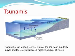
Tsunamis are caused when a large section of the sea floor suddenly moves and displaces a massive amount of water, resulting in waves that can cause devastating damage when they reach land.
Report
Share
Report
Share

Recommended
Tsunami presentation
Tsunamis are series of large waves created by the displacement of water in seas or oceans. They are most commonly caused by earthquakes under the sea floor or volcanic eruptions. Tsunamis have a small amplitude offshore but grow significantly larger as they reach shallower coastal waters. Areas near coastlines are devastated by the fast moving wall of water which can reach heights of 30 meters, destroying homes and structures. The 2004 Indian Ocean tsunami caused widespread damage in the Andaman and Nicobar Islands due to the lack of a warning system.
Tsunami Notes
Tsunamis are large destructive waves caused by geological events such as earthquakes, volcanoes, or landslides that displace large volumes of water. They are most commonly triggered by earthquakes of magnitude 7.0 or higher where the epicenter is located near or below the ocean. When the ocean floor is suddenly displaced by one of these events, it generates a series of long wavelength waves that propagate outward from the source. As these waves enter shallower coastal waters, their speed decreases and wavelength and height increase, sometimes resulting in a massive flooding wave that can cause devastating damage when it reaches land.
Tsunami
This is a PowerPoint Presentation based strictly on Tsunami.
Here one can find the following details about Tsunami:
Definition of Tsunami
Major Causes of Tsunami
Pictures Related to Tsunami
Analytical and Statistical information
And other more useful details .
So Hope you like it
Thankyou
Tsunami ppt
Tsunamis are caused by large earthquakes at subduction zones where tectonic plates meet. In the deep ocean, tsunamis travel very quickly but with small amplitude. As they approach land, their speed slows and their amplitude grows dramatically. Tsunamis cause damage through both the force of the wall of water and the destructive power of a large volume of water draining off the land while carrying large debris. The 2004 Indian Ocean tsunami was caused by a 9.0 magnitude earthquake off the coast of Sumatra, displacing a huge volume of water and causing over 155,000 fatalities across South and Southeast Asia.
Tsunami
A tsunami is a series of waves caused by the displacement of a large volume of water, usually in an ocean, and can be triggered by earthquakes, volcanic eruptions, landslides, and other disturbances above or below water. The 2004 Indian Ocean earthquake and tsunami was one of the most devastating, killing over 230,000 people. Predicting tsunamis is difficult but signs like sudden sea level changes can serve as a brief warning. Safety measures include moving to high ground at least 30 feet above sea level within 20 minutes of a strong earthquake and heading out to sea if in a boat.
Explanation Text about Tsunami
The document summarizes information about tsunamis. It defines a tsunami as a series of waves generated by the rapid displacement of water on a massive scale, which can be caused by earthquakes, landslides, volcanic eruptions, and meteorite impacts. The effect of tsunamis can range from unnoticeable to devastating. It notes that while tsunamis pass unnoticed in deep ocean waters, they take on characteristics of violent tides as they approach land. The document provides both general information about tsunamis and answers specific questions about tsunami causes, effects, terminology, and behavior in deep versus shallow waters.
Earthquake and tsunami
1) An earthquake is intense ground shaking caused by a sudden release of energy, often due to movement along faults within the Earth.
2) Earthquake magnitude is measured by the Richter Scale, where each whole number increase means the amplitude of shaking is 10 times greater. Magnitude 2.5 or less quakes are usually not felt, while anything above 8 can totally destroy communities near the epicenter.
3) Intensity refers to the amount of damage at a location and is measured by scales like Modified Mercalli, depending on factors like distance from the quake and duration of shaking.
Effects Of Waves, Currents, Tides,
Presentation about effects of waves, currents, tides, and storms on geologic features of the ocean shore zone. Based on SC State Standards.
Tsunami
Assalam U Alikum!
In these slides, Tsunami is discussed. First, What is Tsunami then breif history of Tsunami, Characteristics of Tsunami, Terminology of Tsunami, How can you do preparations before, during and after Tsunami came.
I hope you like my slides. Stay tuned for more slides.
Jazak Allah!.
Ocean shore zones
Waves, currents, tides, and storms shape the geological features of ocean shore zones. Beaches are formed from sand deposited by waves along shorelines. Longshore currents move sand along beaches from one area to another. Barrier islands block the mainland from wave effects and their shape changes as sand is deposited and moved by currents. Estuaries are where rivers meet the ocean and have a mixture of fresh and salt water, with sediments deposited by waves and sea life nourished by tidal flows. Inlets between barrier islands change shape due to tides, currents, and storms.
Tsunami
This document summarizes a social science project on tsunamis. It discusses how tsunamis are caused by earthquakes and volcanic eruptions displacing large volumes of water, and how their long wavelengths allow them to travel unnoticed offshore but grow dramatically in shallow water near coasts. It also describes the 2004 Indian Ocean tsunami, one of the deadliest in history, and notes that future tsunamis could affect other areas around the Indian Ocean. The goal of the project is to study tsunami causes, characteristics and impacts in order to help reduce damage and save lives, though tsunamis cannot be prevented.
Tsunami a natural disaster
A tsunami is a series of enormous ocean waves generated by earthquakes, landslides, volcanic eruptions, or meteor impacts that displace large volumes of water and cause catastrophic damage when they reach land. Tsunamis are very difficult to detect when they approach coastal areas out in the open ocean, and can travel at over 500 mph. Areas near fault lines in the Pacific Ocean called "seismic zones" are particularly at high risk of experiencing tsunamis. On December 26, 2004, a 9.3 magnitude earthquake in the Indian Ocean triggered a devastating tsunami that killed over 230,000 people across 14 countries, with deaths reported as far away as Africa.
Ocean waves and tides
Ocean waves are disturbances created when energy moves through water. They have distinct parts including crests, troughs, wavelength, period, and frequency. The breaking of waves on the shore is called surf and occurs in the surf zone. There are also internal waves, seiches, and tsunamis which are large waves caused by underwater earthquakes or landslides.
Tsunami
A tsunami is a series of large ocean waves caused by earthquakes, landslides, or volcanic eruptions under the sea. When these events displace large volumes of water rapidly, they generate tsunami waves that can travel vast distances across the ocean at speeds over 800 km/h. Though often small in deep water, tsunamis grow dramatically in height - up to 30 meters - as they reach shallow coastal waters, being able to destroy coastal villages and cities. The 2004 Indian Ocean tsunami was particularly devastating, killing over 150,000 people across 11 countries when earthquake forces built up over centuries were suddenly released on December 26th, unleashing killer waves across the Indian Ocean.
Ch.5.less.4.what are earthquakes and how do they occur
An earthquake occurs when layers of rock beneath the earth's surface rupture suddenly, releasing stored energy in seismic waves. These waves travel outward from the hypocenter, where the rupture initiates, marking the epicenter at the surface directly above. Several factors influence earthquake occurrence, including plate tectonics and the type and speed of seismic waves produced. Earthquakes are measured by both magnitude scales, indicating energy released, and intensity scales, describing perceived effects on people and structures.
Earthquake -presentation.( Earthquake, Soil Liquification, T- Sunaami, Fire, ...
Earthquake -presentation.( Earthquake, Soil Liquification, T- Sunaami, Fire, ...kabdultayash@gmail.com
Abdul Tayash presented a seminar on earthquakes for the 5th semester civil engineering students at Govt Polytechnic Harapanahalli. The seminar covered the introduction to earthquakes, types of earthquakes and seismic waves, and effects of earthquakes such as soil liquefaction, landslides, fires, tsunamis, and floods. Abdul concluded that earthquakes are a natural destructive force that occur along plate boundaries, and while we can predict where they will happen, not when. Engineers work to design earthquake-resilient structures and retrofit older buildings.Tsunami
Tsunamis are a series of large waves caused by the displacement of water, generally in oceans or large lakes, which can be triggered by earthquakes, volcanic eruptions, landslides, meteorite impacts or other disturbances above or below water. Tsunami waves have an extremely long wavelength compared to normal sea waves and may initially resemble a rapidly rising tide. Wave heights can reach tens of meters and tsunamis can affect entire ocean basins, with the devastating 2004 Indian Ocean tsunami killing over 230,000 people across 14 countries. The term tsunami comes from Japanese, meaning 'harbour wave' and they are sometimes incorrectly called tidal waves.
Earthquake and seismicity
This slide is prepared by me under guidance of my teacher Nirmal Kafle for general understanding about Earthquake and Seismicity. I am very thankful to my teacher and friends. I hope this slide may help you to understand about to understand something about Earthquake.
Gayathri, tsunami ppt
This ppt is about tsunami. it is specially useful for 10 th std students project life. hope it will be useful for you.
Tsunami
Tsunamis are giant waves caused by earthquakes or volcanic eruptions under the sea. They can take less than an hour to reach nearby coasts within 100km, 1-3 hours to reach coasts 100-1000km away, or more than 3 hours to cross oceans and strike coasts over 1000km from the quake epicenter. Signs of an approaching tsunami include strong ground shaking, unusual sea level changes, an abnormally large first wave that may not be the biggest, and a loud ocean roar. Tsunamis consist of a series of waves that can last up to 30 minutes each and pose a danger that may persist for hours or even days. People in coastal areas should immediately evac
Tsunami
A tsunami is a series of water waves caused by the displacement of a large volume of water, often from earthquakes, volcanic eruptions, landslides or other disturbances below or above water. Tsunami waves have a very long wavelength and can cause enormous destruction in coastal areas, with wave heights over tens of metres. The 2004 Indian Ocean tsunami was one of the deadliest natural disasters, killing over 290,000 people across 14 countries.
Science tsunami
A tsunami is a series of waves caused by the displacement of a large volume of water, generally in an ocean or large lake. Earthquakes, volcanic eruptions, underwater explosions, landslides, glacier calvings, meteorite impacts and other disturbances above or below water all have the potential to generate a tsunami. When an earthquake moves the seafloor upward, it also pushes the water upward forming tsunami waves that grow higher as they reach shallower waters. In 2011, a magnitude 9 earthquake in Japan unleashed a tsunami that caused a nuclear disaster and displaced over 230,000 people, many of whom were still living in temporary housing four years later.
Types and causes of earthquakes
This is a powerpoint which explains the types of seismic waves that earthquakes create and the causes of earthquakes in the first place.
Earthquake ,causes,effects- ES ppt
This document provides information about earthquakes. It discusses what causes earthquakes, including the sudden release of energy and faulting or breaking of rocks. The elastic rebound theory is explained, where rocks bend until failure causes a rupture and release of energy in seismic waves. Earthquakes typically occur at plate boundaries, with 80% in the circum-Pacific belt and 15% in the Mediterranean-Asiatic belt. Various types of seismic waves transmit energy from quakes. Surface waves especially can damage buildings. Factors like duration of shaking, soil conditions, and building quality influence earthquake damage.
Tsunami powerpoint
Tsunamis are caused by large displacements of water, usually in oceans, that can be triggered by earthquakes, volcanic eruptions, landslides or meteorite impacts. While tsunamis have extremely long wavelengths and periods in deep ocean waters, they can travel very fast at over 600 mph. When they reach shallow coastal waters, their energy causes the sea level to rise dramatically and flood inland areas. Proper planning, awareness of warning signs and evacuation routes can help minimize damage and save lives during a tsunami.
Earthquake and tsunami
This document provides information about earthquakes and tsunamis. It defines key earthquake terms like focus, epicenter, and magnitude. Earthquakes are caused by the movement of tectonic plates. Different types of seismic waves transmit energy from the earthquake. Mitigation aims to reduce vulnerability, while management coordinates disaster response. The 2004 Indian Ocean earthquake triggered a tsunami that caused widespread damage. A 2015 Nepal earthquake also had devastating impacts due to its shallow depth and location near Kathmandu.
Physics of tsunami
The document discusses the physics behind tsunamis, beginning with the causes of earthquakes. It describes plate tectonics and how the movement of tectonic plates can cause earthquakes. It then explains how earthquakes at sea can generate tsunamis by rapidly displacing large amounts of water. The document outlines how tsunami waves travel long distances at high speeds with little loss of energy. Finally, it discusses the impacts of the 2004 Indian Ocean tsunami, including physical changes to coastlines and islands as well as human impacts.
Tsunamis
1) A tsunami is a series of waves created when large amounts of water are displaced, usually by underwater earthquakes or volcanic eruptions.
2) The 2004 Sumatran tsunami was caused by a magnitude 9.3 earthquake and killed over 225,000 people across 11 countries, making it the deadliest natural disaster on record.
3) Early warning systems were not in place in the Indian Ocean in 2004, but a 10-year old girl who had studied tsunamis recognized the signs and helped evacuate a beach, saving lives.
TRF Sustainable Roles
The native Maué Indian family wants to maintain their traditional ways and prefer outsiders to stay away from their area, though excessive tree cutting and burning risks attracting removal from their homelands by authorities. The Brazilian government aims to balance local and national economic needs with environmental protection. Settlers from Sao Paulo came for a quiet life but see potential income from sustainable rainforest practices. Oxford students research sustainable development projects worldwide to share best practices and lessons learned for preserving rainforests. Greenpeace independently campaigns and educates to protect the environment and promote conservation.
Tibet 4 Continental Collision K Co
The document summarizes how the Himalayas and Tibetan Plateau formed through the collision of the Indian and Eurasian tectonic plates starting around 130 million years ago. Sediment deposited on the ocean floor was subducted or squeezed up to form the highest mountains, as evidenced by fossils like ammonites found high in the mountains. The Indian plate drifted northward into Asia, and the continental crust behaved plastically when compressed under pressure, folding and uplifting to create the Himalayan range.
More Related Content
What's hot
Tsunami
Assalam U Alikum!
In these slides, Tsunami is discussed. First, What is Tsunami then breif history of Tsunami, Characteristics of Tsunami, Terminology of Tsunami, How can you do preparations before, during and after Tsunami came.
I hope you like my slides. Stay tuned for more slides.
Jazak Allah!.
Ocean shore zones
Waves, currents, tides, and storms shape the geological features of ocean shore zones. Beaches are formed from sand deposited by waves along shorelines. Longshore currents move sand along beaches from one area to another. Barrier islands block the mainland from wave effects and their shape changes as sand is deposited and moved by currents. Estuaries are where rivers meet the ocean and have a mixture of fresh and salt water, with sediments deposited by waves and sea life nourished by tidal flows. Inlets between barrier islands change shape due to tides, currents, and storms.
Tsunami
This document summarizes a social science project on tsunamis. It discusses how tsunamis are caused by earthquakes and volcanic eruptions displacing large volumes of water, and how their long wavelengths allow them to travel unnoticed offshore but grow dramatically in shallow water near coasts. It also describes the 2004 Indian Ocean tsunami, one of the deadliest in history, and notes that future tsunamis could affect other areas around the Indian Ocean. The goal of the project is to study tsunami causes, characteristics and impacts in order to help reduce damage and save lives, though tsunamis cannot be prevented.
Tsunami a natural disaster
A tsunami is a series of enormous ocean waves generated by earthquakes, landslides, volcanic eruptions, or meteor impacts that displace large volumes of water and cause catastrophic damage when they reach land. Tsunamis are very difficult to detect when they approach coastal areas out in the open ocean, and can travel at over 500 mph. Areas near fault lines in the Pacific Ocean called "seismic zones" are particularly at high risk of experiencing tsunamis. On December 26, 2004, a 9.3 magnitude earthquake in the Indian Ocean triggered a devastating tsunami that killed over 230,000 people across 14 countries, with deaths reported as far away as Africa.
Ocean waves and tides
Ocean waves are disturbances created when energy moves through water. They have distinct parts including crests, troughs, wavelength, period, and frequency. The breaking of waves on the shore is called surf and occurs in the surf zone. There are also internal waves, seiches, and tsunamis which are large waves caused by underwater earthquakes or landslides.
Tsunami
A tsunami is a series of large ocean waves caused by earthquakes, landslides, or volcanic eruptions under the sea. When these events displace large volumes of water rapidly, they generate tsunami waves that can travel vast distances across the ocean at speeds over 800 km/h. Though often small in deep water, tsunamis grow dramatically in height - up to 30 meters - as they reach shallow coastal waters, being able to destroy coastal villages and cities. The 2004 Indian Ocean tsunami was particularly devastating, killing over 150,000 people across 11 countries when earthquake forces built up over centuries were suddenly released on December 26th, unleashing killer waves across the Indian Ocean.
Ch.5.less.4.what are earthquakes and how do they occur
An earthquake occurs when layers of rock beneath the earth's surface rupture suddenly, releasing stored energy in seismic waves. These waves travel outward from the hypocenter, where the rupture initiates, marking the epicenter at the surface directly above. Several factors influence earthquake occurrence, including plate tectonics and the type and speed of seismic waves produced. Earthquakes are measured by both magnitude scales, indicating energy released, and intensity scales, describing perceived effects on people and structures.
Earthquake -presentation.( Earthquake, Soil Liquification, T- Sunaami, Fire, ...
Earthquake -presentation.( Earthquake, Soil Liquification, T- Sunaami, Fire, ...kabdultayash@gmail.com
Abdul Tayash presented a seminar on earthquakes for the 5th semester civil engineering students at Govt Polytechnic Harapanahalli. The seminar covered the introduction to earthquakes, types of earthquakes and seismic waves, and effects of earthquakes such as soil liquefaction, landslides, fires, tsunamis, and floods. Abdul concluded that earthquakes are a natural destructive force that occur along plate boundaries, and while we can predict where they will happen, not when. Engineers work to design earthquake-resilient structures and retrofit older buildings.Tsunami
Tsunamis are a series of large waves caused by the displacement of water, generally in oceans or large lakes, which can be triggered by earthquakes, volcanic eruptions, landslides, meteorite impacts or other disturbances above or below water. Tsunami waves have an extremely long wavelength compared to normal sea waves and may initially resemble a rapidly rising tide. Wave heights can reach tens of meters and tsunamis can affect entire ocean basins, with the devastating 2004 Indian Ocean tsunami killing over 230,000 people across 14 countries. The term tsunami comes from Japanese, meaning 'harbour wave' and they are sometimes incorrectly called tidal waves.
Earthquake and seismicity
This slide is prepared by me under guidance of my teacher Nirmal Kafle for general understanding about Earthquake and Seismicity. I am very thankful to my teacher and friends. I hope this slide may help you to understand about to understand something about Earthquake.
Gayathri, tsunami ppt
This ppt is about tsunami. it is specially useful for 10 th std students project life. hope it will be useful for you.
Tsunami
Tsunamis are giant waves caused by earthquakes or volcanic eruptions under the sea. They can take less than an hour to reach nearby coasts within 100km, 1-3 hours to reach coasts 100-1000km away, or more than 3 hours to cross oceans and strike coasts over 1000km from the quake epicenter. Signs of an approaching tsunami include strong ground shaking, unusual sea level changes, an abnormally large first wave that may not be the biggest, and a loud ocean roar. Tsunamis consist of a series of waves that can last up to 30 minutes each and pose a danger that may persist for hours or even days. People in coastal areas should immediately evac
Tsunami
A tsunami is a series of water waves caused by the displacement of a large volume of water, often from earthquakes, volcanic eruptions, landslides or other disturbances below or above water. Tsunami waves have a very long wavelength and can cause enormous destruction in coastal areas, with wave heights over tens of metres. The 2004 Indian Ocean tsunami was one of the deadliest natural disasters, killing over 290,000 people across 14 countries.
Science tsunami
A tsunami is a series of waves caused by the displacement of a large volume of water, generally in an ocean or large lake. Earthquakes, volcanic eruptions, underwater explosions, landslides, glacier calvings, meteorite impacts and other disturbances above or below water all have the potential to generate a tsunami. When an earthquake moves the seafloor upward, it also pushes the water upward forming tsunami waves that grow higher as they reach shallower waters. In 2011, a magnitude 9 earthquake in Japan unleashed a tsunami that caused a nuclear disaster and displaced over 230,000 people, many of whom were still living in temporary housing four years later.
Types and causes of earthquakes
This is a powerpoint which explains the types of seismic waves that earthquakes create and the causes of earthquakes in the first place.
Earthquake ,causes,effects- ES ppt
This document provides information about earthquakes. It discusses what causes earthquakes, including the sudden release of energy and faulting or breaking of rocks. The elastic rebound theory is explained, where rocks bend until failure causes a rupture and release of energy in seismic waves. Earthquakes typically occur at plate boundaries, with 80% in the circum-Pacific belt and 15% in the Mediterranean-Asiatic belt. Various types of seismic waves transmit energy from quakes. Surface waves especially can damage buildings. Factors like duration of shaking, soil conditions, and building quality influence earthquake damage.
Tsunami powerpoint
Tsunamis are caused by large displacements of water, usually in oceans, that can be triggered by earthquakes, volcanic eruptions, landslides or meteorite impacts. While tsunamis have extremely long wavelengths and periods in deep ocean waters, they can travel very fast at over 600 mph. When they reach shallow coastal waters, their energy causes the sea level to rise dramatically and flood inland areas. Proper planning, awareness of warning signs and evacuation routes can help minimize damage and save lives during a tsunami.
Earthquake and tsunami
This document provides information about earthquakes and tsunamis. It defines key earthquake terms like focus, epicenter, and magnitude. Earthquakes are caused by the movement of tectonic plates. Different types of seismic waves transmit energy from the earthquake. Mitigation aims to reduce vulnerability, while management coordinates disaster response. The 2004 Indian Ocean earthquake triggered a tsunami that caused widespread damage. A 2015 Nepal earthquake also had devastating impacts due to its shallow depth and location near Kathmandu.
Physics of tsunami
The document discusses the physics behind tsunamis, beginning with the causes of earthquakes. It describes plate tectonics and how the movement of tectonic plates can cause earthquakes. It then explains how earthquakes at sea can generate tsunamis by rapidly displacing large amounts of water. The document outlines how tsunami waves travel long distances at high speeds with little loss of energy. Finally, it discusses the impacts of the 2004 Indian Ocean tsunami, including physical changes to coastlines and islands as well as human impacts.
Tsunamis
1) A tsunami is a series of waves created when large amounts of water are displaced, usually by underwater earthquakes or volcanic eruptions.
2) The 2004 Sumatran tsunami was caused by a magnitude 9.3 earthquake and killed over 225,000 people across 11 countries, making it the deadliest natural disaster on record.
3) Early warning systems were not in place in the Indian Ocean in 2004, but a 10-year old girl who had studied tsunamis recognized the signs and helped evacuate a beach, saving lives.
What's hot (20)
Ch.5.less.4.what are earthquakes and how do they occur
Ch.5.less.4.what are earthquakes and how do they occur
Earthquake -presentation.( Earthquake, Soil Liquification, T- Sunaami, Fire, ...
Earthquake -presentation.( Earthquake, Soil Liquification, T- Sunaami, Fire, ...
Viewers also liked
TRF Sustainable Roles
The native Maué Indian family wants to maintain their traditional ways and prefer outsiders to stay away from their area, though excessive tree cutting and burning risks attracting removal from their homelands by authorities. The Brazilian government aims to balance local and national economic needs with environmental protection. Settlers from Sao Paulo came for a quiet life but see potential income from sustainable rainforest practices. Oxford students research sustainable development projects worldwide to share best practices and lessons learned for preserving rainforests. Greenpeace independently campaigns and educates to protect the environment and promote conservation.
Tibet 4 Continental Collision K Co
The document summarizes how the Himalayas and Tibetan Plateau formed through the collision of the Indian and Eurasian tectonic plates starting around 130 million years ago. Sediment deposited on the ocean floor was subducted or squeezed up to form the highest mountains, as evidenced by fossils like ammonites found high in the mountains. The Indian plate drifted northward into Asia, and the continental crust behaved plastically when compressed under pressure, folding and uplifting to create the Himalayan range.
Y8 air pressure weather march 2013
Quick presentation to show effect of air pressure on weather, focused on Lincolnshire but applicable anywhere in UK
Arid Spain uses and management KC AQA AS level Geography
Case study of Southern Spain (Andalusia, mainly Almeria) for AQA AS Level Geography Arid Environments option - info presented via pics, with info sheets to give out for groupwork / later feedback... - see 'notes' for each slide for teacher explanation...
Coasts Intro Homework
The document provides a list of 14 coastal landform terms along with letters as clues for homework. Students are instructed to learn to identify each term and test themselves, with extensions including taking notes on each term and drawing a labeled sketch of one from photos. Key coastal landforms listed include beaches, cliffs, estuaries, deltas, wave-cut platforms, bays, coves, and headlands.
Tectonic Plates names test
This document appears to be a test containing multiple choice or fill-in-the-blank questions as there are blanks labeled a through d and numbers 1 through 8. The test also lists a name, date and has some blank lines, but provides no other context or content to summarize.
mindsets quiz KC (fixed v growth mindsets - student questionnaire)
A short quiz to ascertain the degree to which students have a fixed mindset or growth mindset (cf Carol Dweck)
0008 Talking Essay Kc Adjusted Nicola Gamble
I've just nicked and adjusted the card-sort part of the 'talking essay' idea on the QCA innovating geography site - by Nicola Gamble from Comberton Village College - the idea is for the 6 big idea card to be placed on different tables, then students to be given 1 or 2 of the statements and they have to find the right 'big idea' card to place them... then they do some thinking skill / sorting exercise - 1 group per big idea (e.g. an order of importance etc)
AS geography grey areas and key concepts
This document outlines several important concepts in geography related to grey areas, sustainability, and perspectives. It discusses topics such as rivers, cold environments, population, and energy. For each topic, it lists key concepts and processes to understand, including the hydraulic radius and storm hydrograph for rivers, glacial and periglacial landforms in cold environments, population pyramids and policies, and renewable and alternative energy sources. It emphasizes learning specifics for case studies and considering different perspectives.
Coasts Intro Test
The document contains terms related to coastal landforms and features including:
- A coastal town where people holiday is a resort.
- The softest cliffs are made of chalk.
- Where sand or stones have been naturally deposited by the sea is a beach.
- When a clay cliff collapses is slumping.
Geology OCR A-level igneous rocks terms revision interactive - need to downlo...
OCR Geology AS-level igneous terms - all terms from Specification covered - interactive so students can self-test
A level glaciation millionaire print quiz
To go with millionaire game also uploaded here... to be printed out (I do 3 slides per page with lines for notes - then ask students to explain / justify their answers...)
Sustainable Development Of Tropical Rainforests
PowerPoint for lesson on sustainable development in rainforests, based on Amazon - designed for bright Y10
Rock identification igneous kc
Help for A-level Geology students in identifying the main igneous rocks - interactive so you can test yourself as you go...
Weathering and erosion
The document discusses the processes of weathering and erosion. Weathering is when rocks break up, while erosion is when rocks wear away. There are 5 main ways rivers erode: 1) abrasion when sand and stones are bashed against banks, 2) corrosion when acidic water dissolves banks, 3) hydraulic action when water forces cracks apart, 4) attrition when stones knock into each other while being washed along, and 5) corrasion when the river scrapes stones along its bed. Mnemonic devices are provided to help remember the terms.
Coasts Intro Lesson
The document lists 14 coastal landform terms and their definitions. Students were asked to match each term with its description by considering photos, maps, and descriptions provided. The terms included beach, cliff, estuary, delta, wave-cut platform, bays, cove, clay, chalk, resort, harbour, headlands, shingle, and slumping. The student answers each term correctly by working through the activity over time.
Viewers also liked (16)
Arid Spain uses and management KC AQA AS level Geography
Arid Spain uses and management KC AQA AS level Geography
mindsets quiz KC (fixed v growth mindsets - student questionnaire)
mindsets quiz KC (fixed v growth mindsets - student questionnaire)
Geology OCR A-level igneous rocks terms revision interactive - need to downlo...
Geology OCR A-level igneous rocks terms revision interactive - need to downlo...
More from Kevin Cooper
A level glaciation millionaire
Fun game testing learning of some key terms and concepts from AQA AS Geography Glaciers part of Cold Environments option topic - but equally applicable to OCR and WJEC and probably other courses too. See separate upload for written quiz with same questions for printing and distribution for more formal individual testing of learning. Some of the answers you might find a little idiosyncratic to my way of teaching and things I emphasise that you may not wish to (e.g. moraine as a landform, till as the substance) - but you can change any you don't like!! Let me know if you like it and use it - I may produce some more for other parts of course (e.g. fluvio- or peri-glaciation), and I'll definitely upload them and link on the AQA ning if others want to use them. I've written some notes at the bottom of the slides of some of the harder Qs - but ask here or on the ning if anything unclear etc...
Sustainable development in Masoala / Madagascar
The document discusses sustainable development practices in Madagascar that balance environmental protection and economic opportunities for local communities. The most biologically diverse areas were made into parks where no natural resources can be harmed, and park rangers help enforce this. Nearby accessible areas allow sustainable activities like selective logging and harvesting to provide livelihoods. Examples of sustainable practices discussed include ecotourism lodges that use local materials and support employees, regulated logging that protects some trees, and crops like vanilla and butterflies. The document asks how to achieve sustainable development economically, socially, and environmentally, and which options would be best.
Detroit
The document discusses environmental problems associated with abandoned factory sites in Detroit, such as heavy metal contamination of water supplies and soils from runoff. It also mentions potential sustainable redevelopment opportunities in Detroit, such as urban agriculture, which could help address issues like unemployment, obesity, and government subsidies. However, redevelopment faces barriers like existing contamination, lack of motivation, and resistance from companies like Walmart.
Korea quiz
The document discusses four different names for Korea and orders them A to D. It then lists items and ranks countries' performances, with South Korea generally performing better than North Korea in areas like the World Cup and economic wealth. South Korea is described as the 12th richest country.
Anglo chinese glossary for_geography
This document is an English-Chinese glossary of geographical terms commonly used in teaching geography in secondary schools in Hong Kong. It is divided into two parts, with the first part covering geographical terms and the second part covering GIS terms. The glossary provides Chinese translations for English terms, along with explanatory notes and examples. It is intended to assist teachers, students, and other stakeholders involved in geography education.
Himalaya Formation Millionaire
who wants to be a millionaire game for use as plenary / homework task following lesson based on PPt included here on Himalaya formation
Rio Favelas Etc
Rio de Janeiro is known as the "City of God" due to its natural beauty including mountains, beaches and the iconic statue of Christ overlooking the city. The climate is warm and dry but with enough rain to avoid drought. Locals, called Cariocas, have a reputation for being fun-loving and relaxed. The document discusses the contrasts between wealth and poverty in Rio, noting that the wealthy live in luxury apartments while the poor live in favelas, or hillside slums, with over 100,000 people living in just one favela called Rocinha. It also profiles two hypothetical Cariocas with very different lifestyles.
More from Kevin Cooper (7)
Tsunamis
- 1. Tsunamis Tsunamis result when a large section of the sea floor suddenly moves and therefore displaces a massive amount of water.
- 2. Tsunamis Tsunamis result when a large section of the sea floor suddenly moves and therefore displaces a massive amount of water.