Blueprint exit -exam focus
Surveying (Ethiopian Civil Service University)
Scan to open on Studocu
Studocu is not sponsored or endorsed by any college or university
Blueprint exit - exam focus
Surveying (Ethiopian Civil Service University)
Scan to open on Studocu
Studocu is not sponsored or endorsed by any college or university
Downloaded by Soorii Oroman (sooriioroman21@gmail.com)
lOMoARcPSD|60295504
2.
Ministry of Education
TestBlueprint for National Exit Examination to be held in
2015 E.C
Band: 1 (One)
Program: - Bachelor of Science Degree in Surveying Engineering
Compiled By:
1. Abel Daniel (Lecturer, Arba Minch University)
2. Shimelis Girma (Lecturer, Arba Minch University)
January, 2022
Ministry of Education
Addis Ababa, Ethiopia
Downloaded by Soorii Oroman (sooriioroman21@gmail.com)
lOMoARcPSD|60295504
3.
ii
Table of Contents
1.Introduction ........................................................................................................................1
2. Objective/ Significance of Test Blueprint Preparation.......................................................2
3. Expected profile of the graduates .......................................................................................2
4. Objective (General and specific) ........................................................................................3
5. Themes, list of courses and allocated ECTS ......................................................................4
6. Share of the Themes/Courses/Items in Percentage (%)......................................................4
7. Learning outcomes in terms of the three domains (Cognitive, Affective and
Psychomotor).............................................................................................................................6
7.1. Cognitive.....................................................................................................................6
7.2. Affective......................................................................................................................6
7.3. Psychomotor................................................................................................................6
8. Test blueprint Table (Table of Specification).....................................................................7
9. Conclusion........................................................................................................................11
Downloaded by Soorii Oroman (sooriioroman21@gmail.com)
lOMoARcPSD|60295504
4.
1
1. Introduction
The Ministryof Education of Ethiopia has announced the implementation of exit exam
for all undergraduate program students (public and private), beginning with the
2022/2023 academic year, in order to improve the quality of graduates produced by
higher learning institutions. The exit exam aimed at checking whether students have
acquired the required knowledge, skills and attitudes or not. To implement this, it
requires determining competency areas for a specific program, which is already
completed. Based on the competency areas prepared, it needs to plan the construction of
tests.
Planning of a test is a first and vital step in the construction of an achievement test. An
achievement test demands very systematic and careful planning, as a fact that good
planning is a symbol of success. Tests are the tools that provide scores that measure level
of student learning and study program learning outcomes. In order to achieve the valid
and reliable measurement of student learning and program learning outcomes, the
development of valid and reliable test is the mandatory. Test should be able to measure
student performance in all dimensions of knowledge, skill and attitude. The carefully
planned test construction contributes to improve the overall quality of the test in terms of
test content validity, difficulty level, discrimination power and test reliability. Test
preparation is not an easy task; it requires a careful planning and guideline to make the
task simple. Test construction needs the preparation of test blue print. Test blueprint is
defined as a complete plan that explains how to develop a test. The term refers to a map
or specification of assessment to ensure that all aspects of the curriculum and educational
domains are covered by the assessment programs over a specified period of time. It helps
curriculum developers/test constructors to match various competencies with the course
content and the appropriate modality of assessment.
Generally, test blueprint will help to ensure tests: 1) Appropriately assess the achievement
of instructional objectives of the course; 2) Appropriately reflect key course goals,
objectives and the material learned or covered during the instruction period; and 3)
Include the appropriate item formats along with the knowledge and skills being assessed.
Downloaded by Soorii Oroman (sooriioroman21@gmail.com)
lOMoARcPSD|60295504
5.
2
Keeping this inmind, the team has prepared this test blueprint document in order to help
the test developers or content specialists in their process of valid and reliable test
construction. The major points considered in the process of preparing this test blue print
guideline were the core competencies that have been already identified for the themes of
courses, the course contents, course credit hours, and the learning outcomes with their
corresponding levels of achievement by learning domains. In line with these, the number
of test items that should adequately assess the performance of students in all the content
topics will be determined through discussion with the content specialists who construct
the blueprint and test for their corresponding study program.
Therefore, the main purpose of this manual is to give direction on how to develop
blueprint for content specialists so that they can develop a test blueprint for their
respective program.
2. Objective/ Significance of Test Blueprint Preparation
Test blueprint preparation is generally opted to assist the preparation of a test that is
representative, broadly sampled, and consisting of complete knowledge domain expected
of the Ethiopian higher education students on completion of their study program. The
specific objectives of test blueprint are to:
Facilitate the construction of a representative and balanced test items for the
selected courses in accordance with the competencies identified.
Guide test developers or writers to write or set appropriate test items.
3. Expected profile of the graduates
The graduates of the Surveying Engineering program should demonstrate competency in one
or more of the following Surveying Engineering competency areas: boundary/land surveying,
photogrammetry, geodesy, GIS, cartography, cadaster and other related area of applications.
The graduates of the Surveying Engineering program should apply basic
mathematical, scientific, legal and measurement principles that form the theoretical
framework of professional surveying practice.
Downloaded by Soorii Oroman (sooriioroman21@gmail.com)
lOMoARcPSD|60295504
6.
3
The graduatesof the Surveying Engineering program should undertakes
reconnaissance, preliminary and construction activities in civil engineering, irrigation
and construction projects.
The graduates of Surveying Engineering program should plan, manage, monitor and
evaluate Geospatial engineering projects.
The graduates of Surveying Engineering program should select and properly use
appropriate techniques and tools to collect, analyze and interpret data to obtain
optimum surveying solutions for different situations in the country.
The graduates of the Surveying Engineering program should demonstrate professional
and Ethical responsibilities of surveying engineers in relation to public and private
institutions.
4. Objective (General and specific)
The national public administration exit exam shall have the following objectives
To produce skilled and competent manpower to national and international market
Assessing students’ educational achievement in major areas of Surveying
Engineering.
Ensuring whether the graduation profile of Surveying Engineering curriculum have
achieved at least common standards of knowledge and practical skills
Improving public trust and confidence in Surveying Engineering activities of
professionals
Facilitating the efforts of students to revise the core learning outcomes of the courses
covered by the exit examination
Ensuring all graduates from HEIs satisfy the requirements of the labor market and
employability through the national wide implementation of competency-based exit
exam
Creating competitive spirit among Surveying Engineering department in Ethiopia
with the vies to encouraging them to give due attention to the national standards
Downloaded by Soorii Oroman (sooriioroman21@gmail.com)
lOMoARcPSD|60295504
7.
4
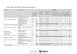
5. Themes, listof courses and allocated ECTS
The above listed course included in the exit exam are categorized based the relationship
subject matter of the courses and learning outcomes.
Table 1: Theme, list of course and allowed ECTS
S.N Course theme Course name Course ECTS
1 Basic of Surveying 1 Fundamentals of Surveying 5
2 Route Surveying 5
3 Topographic Surveying 5
4 Construction Surveying 5
5 Cadastral Surveying 5
2 GIS and Cartography 6 Cartography 10
7 GIS 10
8 Spatial Database Management System 5
3 Remote Sensing and
Photogrammetry
9 Remote Sensing 5
10 Digital Image Analysis 5
11 Photogrammetry 10
4 Geodesy 12 Geodesy (Introduction and Control Surveying) 5
13 Global Positioning System (GPS) 5
14 Adjustment of Surveying Measurements 5
Total 85
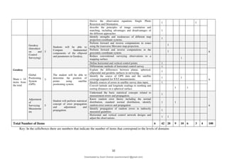
6. Share of the Themes/Courses/Items in Percentage (%)
o Share of themes (T) = Where “a” is the credit hour of a theme and “b” is the total
credit hour of the program. Credit hour of a theme is the sum of credit hours of courses in
the theme.
o Share of courses per theme (C) =
o Share of items per course =
Downloaded by Soorii Oroman (sooriioroman21@gmail.com)
lOMoARcPSD|60295504
8.
5
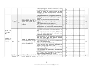
Table 2: Shareof the Themes/Courses/Items in Percentage (%)
Themes Course Name
Number
of
Learning
outcomes
ECTS
Weight of
course or
proportion
Number of test
items from
each course
Cognitive
Affective
Psychomotor
Total
Remember
Understand
Application
Analysis
Evaluation
Creation/Sy
nthesis
Theme One: Basics of Surveying
Share = 29 items from the total
Fundamentals of Surveying 5 5 5/25 = 0.2 0.2*29 = 6 1 1 2 1 2 - 1 - 6
Route Surveying 4 5 5/25 = 0.2 0.2*29 = 6 1 - 2 - 2 1 - - 6
Topographic Surveying 4 5 5/25 = 0.2 0.2*29 = 6 1 - 3 1 - - - 1 6
Construction Surveying 4 5 5/25 = 0.2 0.2*29 = 6 1 2 1 - 1 - - 1 6
Cadastral Surveying 5 5 5/25 = 0.2 0.2*29 = 6 - 3 2 - - - - 1 6
Theme one total credit 25 Total items per theme one (Basics of Surveying) 30
Theme Two: GIS and Cartography
Share = 29 items from the total
Cartography 7 10 10/25 = 0.4 0.4*29 = 12 1 5 2 1 - 2 - 1 12
GIS 7 10 10/25 = 0.4 0.4*29 = 12 - 6 1 3 1 1 - - 12
Spatial Database Management
System 6 5 5/25 = 0.2 0.2*29 = 6 - 3 1 - - 1 1 - 6
Theme two total credit 25 Total items per theme two (GIS and Cartography) 30
Theme Three:
Remote Sensing and
Photogrammetry
Share = 23 items from the total
Remote Sensing 5 5 5/20 = 0.23 0.25*23 = 6 - 4 1 - 1 - - - 6
Digital Image Analysis 4 5 5/20 = 0.23 0.25*23 = 6 3 2 1 - - - - - 6
Photogrammetry 10 10 10/20 = 0.31 0.5*23 = 10 - 6 1 1 1 - 1 - 10
Theme three total credit 20 Total items per theme three (Remote sensing and photogrammetry) 22
Theme four: Geodesy
Share = 18 items from the total
Geodesy (Introduction and Control
Surveying)
6 5 5/15 = 0.33 0.33* 18 = 6 - 3 2 - 1 - - - 6
Global Positioning System (GPS) 4 5 5/15 = 0.33 0.33* 18 = 6 - 3 - 1 1 1 - - 6
Adjustment of Surveying
Measurements
4 5 5/15 = 0.33 0.33* 18 = 6 - 4 1 1 - - - - 6
Theme three total credit 15 Total item per theme four (Geodesy) 18
Total for the program 85 Total Items of the program 6 42 20 9 10 6 3 4 100
Downloaded by Soorii Oroman (sooriioroman21@gmail.com)
lOMoARcPSD|60295504
9.
6
7. Learning outcomesin terms of the three domains (Cognitive,
Affective and Psychomotor)
The graduate of Surveying Engineering degree program should have the following learning
outcomes
7.1. Cognitive
The cognitive domain aims to develop the mental skills and the acquisition of knowledge of
the individual. The cognitive domain encompasses of six categories which include
knowledge; comprehension; application; analysis; synthesis; and evaluation.
7.2. Affective
The affective domain includes the feelings, emotions and attitudes of the individual. The
categories of affective domain include receiving phenomena; responding to phenomena;
valuing; organization; and characterization. The sub domain of receiving phenomena creates
the awareness of feelings and emotions. As well as the ability to utilize selected attention.
This can include listening attentively to lessons in class. The next sub domain of responding
to phenomena involves active participation of the learner in class or during group discussion.
Discern differences between database structures of geo-relational versus object-
relational databases in a GIS.
7.3. Psychomotor
The psychomotor domain includes utilizing motor skills and the ability to coordinate them.
The sub domains of psychomotor include perception; set; guided response; mechanism;
complex overt response; adaptation; and origination. Perception involves the ability to apply
sensory information to motor activity. For instance, a student practices a series of exercises in
a text book with the aim of scoring higher marks during exams. Set, as a sub domain,
involves the readiness to act upon a series of challenges to overcome them. In relation to
guided responses, it includes the ability to imitate a displayed behaviour or utilize a trial and
error method to resolve a situation.
Downloaded by Soorii Oroman (sooriioroman21@gmail.com)
lOMoARcPSD|60295504
10.
7
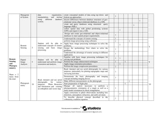
8. Test blueprintTable (Table of Specification)
Themes/
Discipline
Courses Cou
rse
ECT
S
General objective/
Competencies
Specific objectives /learning outcomes
Learning outcomes
No.
of
items
Cognitive
Remembering
Understanding
Application
Analysis
Evaluation
Creation/Synth
esis
Affective
Psychomotor
Basics of
Surveying
Share = 29
items from
the total
Fundament
als of
Surveying
5
Basic concepts of surveying,
applications, instruments,
angles and distance
measurement and traversing.
Explain the basic concepts of surveying, branches, and
applications.
1
6
Surveying instruments, units of measurements, Scales,
precision, and accuracy.
1
Types and sources of errors and corrections methods 1
Measurements of distance, angles and direction 1 1
Traverse types and computation 1
Route
Surveying
5
Student will understand and
perform route surveying, types
of curves, setting out and earth
work.
Explain the procedures of route surveying, 1
6
Compute elements of Vertical curves and horizontal
angles,
1
Set out profile and cross section the curve, 1 1
Compute Earthwork, engineering works. 1 1
Topographi
c
Surveying
5
Students will understand and
perform in collecting natural
and man-made features and
topographic mapping.
Explaining topography, topographic map and purpose. 1
6
Establishing control points 1 1
Data collection using stadia method 1
Plotting and contour generation 1 1
Constructio
n
Surveying
5
Students will use the surveying
knowledge for linear
engineering and construction
Explaining construction surveying 1
6
Types of construction surveying projects 1
Field note management, reason and requirements 1 1
Performing setting out of engineering structures using
different surveying equipment 1 1
Cadastral
Surveying
5
•Understand the need for
efficient and effective land
administration systems and
spatial data infrastructures.
Understand the need for efficient and effective land
administration systems and spatial data infrastructures.
1
6
Technologies for developing and land administration in
both developed and developing countries
1
conduct property surveying & mapping and registration 1 1
Downloaded by Soorii Oroman (sooriioroman21@gmail.com)
lOMoARcPSD|60295504
11.
8
Understand the history,practice, legal aspect of land
surveying in the Ethiopia.
1
Explain the Deeds and Torrens Systems of Land
Registration and their relevance for land tenure and
cadastral systems
1
5GIS and
Cartograp
hy
Share = 29
items from
the total
Cartograph
y 10
Able to design and compile
different purpose maps and to
project and compile maps
using recommended software
programs
Understand scientific base of cartography and branches 1
12
Identifying map elements and basic principles of
mapping.
1
Perform map design, layout and map reproduction. 1 1
Acquiring knowledge on map projection and its
property.
1
Types of map construction and production. 1 1
Map quality, accuracy and cartographic standard. 1 1 1
Mapping natural and socio-economic data using digital
cartography
1 1
GIS 10
Student will understand basic
concepts, data models and GIS
data analysis techniques for
decision making process.
Understand the definition, history and application of
GIS.
1
12
Learn basic steps to create and maintain GIS data and
perform GIS analysis and present the results in the form
of hard copy maps or digital form.
1 1
Relate and identify the GIS data sources and integrate
these data sources with their respected attribute
representation in the GIS environment
1 1
Understand in detail the GIS data models and practically
apply in their practical classes
1
Analysing vector and raster data models. 1
Collect data from their environment and apply the
theoretical concepts to the practical world.
1
Understanding of spatial analysis, techniques, available
within GIS environment.
1
Know its capability and applications in various decision
making processes.
1 1
Know a range of topics including filed based capture of
spatial information and spatial data structure.
1
Spatial
Database
5
Students will understand and
develop Spatial and attribute
explain spatial data organization structures at various
spatial scales; 1 6
Downloaded by Soorii Oroman (sooriioroman21@gmail.com)
lOMoARcPSD|60295504
12.
9
Manageme
nt System
data organization,
manipulation,and storing
using different database
system.
create conceptual models of data using top down and
bottom up approaches;
1
discern differences between database structures of geo-
relational versus object-relational databases in a GIS;
1
create and query databases using structured query
language (SQL);
1
collect spatial data with global positioning systems
(GPS) and import it into a GIS; 1
Design and create geo-relational and object-relational
databases to meet spatial project requirements. 1
Remote
Sensing
and
Photogra
mmetry
Share = 2
items from
the total
Remote
Sensing 5
Student will be able to
understand concepts of remote
sensing, and basic image
processing
Understand the concepts of remote sensing 1
6
perform image processing using softwares 1 1
Apply basic image processing techniques to solve the
problems,
1
Design the methodology flow charts to solve the
problems
1
Understand the advantage of remote sensing in different
application.
1
Digital
Image
Analysis
5
Student will be able to
understand and perform image
restoration and analysis.
Familiar with basic image processing techniques for
solving real problems
1 1
6
Perform the image enhancement techniques 1 1
Apply image restoration procedures. 1
Perform the image compression procedures. 1
Photogram
metry
10
Read, interpret and use aerial
photographs for various
purposes, Photo Resection
and Orientation and creating
an orthophoto and vector map
Read, interpret and use aerial photographs for various
purposes, particularly for plotting topographic maps and
surveying activities
1
10
Demonstrate the basic photography and imaging
concept including imaging device
1
Make different measurements on the photograph 1
State preparation of flight plan 1
Manage all aspects necessary to perform a
photogrammetric orientation of a single as well as a
multi model orientation by block triangulation
1
Apply corrections to photo observations including lens
distortion, atmospheric refraction, and earth curvature.
1
To describe physical concept described in the
collinearity condition equation.
1
Downloaded by Soorii Oroman (sooriioroman21@gmail.com)
lOMoARcPSD|60295504
13.
10
Key: In thecells/boxes there are numbers that indicate the number of items that correspond to the levels of domains
Derive the observation equations Single Photo
Resection and Orientation.
1 1
describe the principles of image correlation and
matching, including advantages and disadvantages of
the different approaches
1
Geodesy
Share = 18
items from
the total
Geodesy
(Introducti
on and
Control
Surveying)
5
Students will be able to
Compute fundamental
components of the ellipsoid
and parameters in Geodesy.
Identify strengths and weaknesses of different map
projection coordinate systems.
1
6
Perform forward and inverse computations in zones
using the transverse Mercator map projection.
1
Perform forward and inverse computations in the
geocentric coordinate system.
1
Reduce conventional surveying observations to a
mapping surface. 1
Define horizontal and vertical control points 1
Differentiate methods of horizontal control survey 1
Global
Positioning
System
(GPS)
5
The student will be able to
determine the position of
points using satellite
positioning system.
Explain the differences between planar, spherical,
ellipsoidal and geodetic surfaces in surveying
1
6
Identify the source of GPS data and the satellite
coverage required for XYZ measurements
1 1
Identify sources of errors in satellite survey data input, 1
Convert latitude and longitude readings to northing and
easting distances on a spherical surface. 1 1
Adjustment
of
Surveying
Measureme
nts
5
Student will perform statistical
concept of error propagation
and adjustment and
propagation.
Understand the basic statistical concepts related to
measurement errors and propagation.
1
6
Know random error theory including the normal
distribution, standard normal distribution, identify
random error sources and propagation
1 1
Identify propagation of random errors in indirectly
measured quantities
1
Horizontal and vertical control network designs and
adjust the observations.
1 1
Total Number of Items 6 42 20 9 10 6 3 4 100
Downloaded by Soorii Oroman (sooriioroman21@gmail.com)
lOMoARcPSD|60295504
14.
11
9. Conclusion
Exit examinationcan have a vital role in producing knowledgeable, skillful and
attitudinally matured graduates. It contributes to prepare competent graduates as it can
serve as a quality check for effectiveness. It also helps in improving academic programs
quality and effectiveness. Furthermore, it can create the platform for cooperation among
academic programs at different universities to work jointly to improve the programs
quality.
In view of this, this document is produced to assist the setting of the exit examinations
for surveying engineering programs, which is being delivered by Ministry of Education.
To meet the graduation profile, competency and learning outcome, exit exam
competency selection and identifying core course was done for 2015 EC graduating
students. As a result, preparing test blueprint is necessary to prepare fairly distributed
items based on the above criteria.
Generally in the preparation of this blueprint for surveying engineering enumerates 100
items of question was fixed from the courses and learning outcomes stated above. The
items indicated above are categorized under three learning outcome domains which are
cognitive, affective and psychomotor.
Downloaded by Soorii Oroman (sooriioroman21@gmail.com)
lOMoARcPSD|60295504