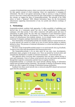
The document discusses building a "fourth way" to develop spatial data infrastructures (SDI) by combining standards, commercial initiatives, and community contributions. It proposes a "Geoportal4everybody" that would allow sharing spatial and non-spatial information through social networks and other means. The approach is based on open-source software and aims to make SDI development more accessible and distributed.
![IST-Africa 2011 Conference Proceedings
Paul Cunningham and Miriam Cunningham (Eds)
IIMC International Information Management Corporation, 2011
ISBN: 978-1-905824-24-3
Social Space for Geospatial Information
Karel CHARVAT1, Premysl VOHNOUT1, Stepan KAFKA2, Jachym CEPICKY2,
Tomáš MILDORF3, Karel JANECKA3, Tomas CHVATAL1
1
Ceske Centrum pro vedu a Spolecnost, Radlicka 28, Praha, 150 00, Czech Republic
Tel: +420 281 973501, Fax: +420 281 973501, Email: ccss@ccss.cz
2
Help service-remote sensing, Vnouckova 614, Benesov, 256 01, Czech Republic
Tel: +420 317 724620, Fax: + 420 317 724620, Email:bnhelp@bnhelp.cz
3
Faculty of Applied Sciences, University of West Bohemia in Pilsen,
Univerzitni 22, Plzen, 306 14, Czech Republic
Tel: +420 377 632691, Fax: + 420 377 632602, Email: kjanecka@kma.zcu.cz
Abstract: This paper introduces ideas to build a social space for sharing spatial data
and spatial information. It includes also the experience with sharing of spatial data
and spatial information. The objective of 4th way to SDI is not to build a single node
or access point for accessing or collecting spatial information but to build a network
of nodes, where every node could be an access point for spatial information. The
objective of 4th way to SDI should not be understood as an alternative of public
initiatives including INSPIRE, GEOSS, GMESS or UNSDI but to give a chance to
anybody to profit from formed Global SDI using standards coming from this
initiatives and using interoperability rules defined mainly by Open Geospatial
Consortium and W3C. The objective of 4th way to SDI is not to replace such useful
initiatives as OpenStreetMap, but to make results of the initiatives more accessible
for everybody. The objective of 4th way to SDI is not to remove such solution like
Google Maps or Microsoft Live Maps, but give some alternative, where on one side
people could share information in different environment including for example
Google. The objective of 4th way to SDI is to support utilisation of Open Sources.
Proprietary solutions are not excluded from the network. A key aspect is
interoperability. Objective of 4th way to SDI is also to give a chance to share and use
spatial information by people, who do not have necessary infrastructure.
Keywords: SDI, Social Networks, Communities, URM, GeoHosting
1. Introduction
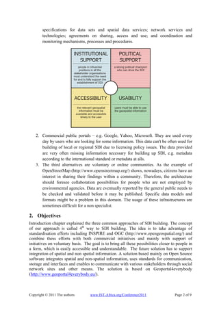
There can be identified four basic blocks for SDI building: institutional support, political
support, accessibility and usability [6]. As depicted on the following figure, we see a gap in
the SDI building. This article should stress out the importance of user involvement in SDI
building representing the gap.
What are the methods to build Spatial Data Infrastructure (furthermore referred to as
SDI)? What is the future of SDI building in development countries? How developing
countries could profit from new technologies? How experiences from Europe could be
implemented in Africa? And what we can do together? These are the main questions, which
we would like to address and discuss.
The most frequent ways how to build SDI are:
1. Building SDI by public administration in Europe is public based SDI mainly
supported by the INSPIRE initiative (http://inspire.jrc.ec.europa.eu/). There are
defined certain rules for data sharing and their life cycle. They include metadata,
Copyright © 2011 The authors www.IST-Africa.org/Conference2011 Page 1 of 9](https://image.slidesharecdn.com/istafricapaperref115doc3988-110830155418-phpapp01/85/Social-Space-for-Geospatial-Information-1-320.jpg)
![IST-Africa 2011 Conference Proceedings
Paul Cunningham and Miriam Cunningham (Eds)
IIMC International Information Management Corporation, 2011
ISBN: 978-1-905824-24-3
Social Space for Geospatial Information
Karel CHARVAT1, Premysl VOHNOUT1, Stepan KAFKA2, Jachym CEPICKY2,
Tomáš MILDORF3, Karel JANECKA3, Tomas CHVATAL1
1
Ceske Centrum pro vedu a Spolecnost, Radlicka 28, Praha, 150 00, Czech Republic
Tel: +420 281 973501, Fax: +420 281 973501, Email: ccss@ccss.cz
2
Help service-remote sensing, Vnouckova 614, Benesov, 256 01, Czech Republic
Tel: +420 317 724620, Fax: + 420 317 724620, Email:bnhelp@bnhelp.cz
3
Faculty of Applied Sciences, University of West Bohemia in Pilsen,
Univerzitni 22, Plzen, 306 14, Czech Republic
Tel: +420 377 632691, Fax: + 420 377 632602, Email: kjanecka@kma.zcu.cz
Abstract: This paper introduces ideas to build a social space for sharing spatial data
and spatial information. It includes also the experience with sharing of spatial data
and spatial information. The objective of 4th way to SDI is not to build a single node
or access point for accessing or collecting spatial information but to build a network
of nodes, where every node could be an access point for spatial information. The
objective of 4th way to SDI should not be understood as an alternative of public
initiatives including INSPIRE, GEOSS, GMESS or UNSDI but to give a chance to
anybody to profit from formed Global SDI using standards coming from this
initiatives and using interoperability rules defined mainly by Open Geospatial
Consortium and W3C. The objective of 4th way to SDI is not to replace such useful
initiatives as OpenStreetMap, but to make results of the initiatives more accessible
for everybody. The objective of 4th way to SDI is not to remove such solution like
Google Maps or Microsoft Live Maps, but give some alternative, where on one side
people could share information in different environment including for example
Google. The objective of 4th way to SDI is to support utilisation of Open Sources.
Proprietary solutions are not excluded from the network. A key aspect is
interoperability. Objective of 4th way to SDI is also to give a chance to share and use
spatial information by people, who do not have necessary infrastructure.
Keywords: SDI, Social Networks, Communities, URM, GeoHosting
1. Introduction
There can be identified four basic blocks for SDI building: institutional support, political
support, accessibility and usability [6]. As depicted on the following figure, we see a gap in
the SDI building. This article should stress out the importance of user involvement in SDI
building representing the gap.
What are the methods to build Spatial Data Infrastructure (furthermore referred to as
SDI)? What is the future of SDI building in development countries? How developing
countries could profit from new technologies? How experiences from Europe could be
implemented in Africa? And what we can do together? These are the main questions, which
we would like to address and discuss.
The most frequent ways how to build SDI are:
1. Building SDI by public administration in Europe is public based SDI mainly
supported by the INSPIRE initiative (http://inspire.jrc.ec.europa.eu/). There are
defined certain rules for data sharing and their life cycle. They include metadata,
Copyright © 2011 The authors www.IST-Africa.org/Conference2011 Page 1 of 9](https://image.slidesharecdn.com/istafricapaperref115doc3988-110830155418-phpapp01/75/Social-Space-for-Geospatial-Information-1-2048.jpg)
![9. Conclusions
The way of the presented solution is to increase general participation of all groups of
stakeholders and users in SDI building. Current initiatives are usually based on top down
approach. A feedback on SDI building seems to be essential for meeting the requirements
of governmental bodies and users – drivers of the SDI. It was proven during the execution
of the previously mentioned projects that it is feasible to build up such communication
which will be performed in both directions (from users to SDI and vice versa). It is
necessary to combine current standardisation work and to support bottom up approach in
SDI building by involving public bodies and private initiatives, communities and social
network sites. Further work has to be done in this field, especially in the analysis of the
feedback from users and assessment of reliability of the user feedback.
The above mentioned technologies were developed within the frame of these projects:
Plan4all - the solution was achieved with financial co-funding by the European
Commission within the eContentplus with registration number 318007.
enviroGRIDS @ Black Sea Catchment - the solution was achieved with financial co-
funding by the European Commission within the Seventh Framework Programme with
registration number 226740 and name “Building Capacity for a Black Sea Catchment
Observation and Assessment System supporting Sustainable Development”
BRISEIDE - the solution was achieved with financial co-funding by the European
Commission within the Competitiveness and Innovation framework Programme with
registration number 250474 and name “BRIdging SErvices, Information and Data for
Europe”
HABITATS - the solution was achieved with financial co-funding by the European
Commission within the Competitiveness and Innovation framework Programme with
registration number 250455 and name “Social Validation of INSPIRE Annex III Data
Structures in EU HABITATS”
The technologies are further disseminated throughout the following projects:
NATURNETPLUS - the solution was achieved with financial co-funding by European
Commission within the Lifelong Learning Programme [CZ/09/LLP-LdV/TOI/134009]
SDI-EDU - the solution was achieved with financial co-funding by the European
Commission within the Lifelong Learning Programme [CZ/09/LLP-LdV/TOI/134010]
The technologies are fully operational in the following institutions:
CENIA - Czech Environmental Information Agency, Prague, Czech Republic
Red de difusión de la Investigación en Ciencias Sociales y Jurídicas (REDISCJ),
Canaria Islands, Spain
Zemgales plānošanas reģions, Latvia
References
[1] Karel CHARVAT, Stepan KAFKA, Marek SPLICHAL, Ota CERBA, Jelle HIELKEMA Uniform
Resource Management, IST Africa 2008, Windhoek, May 2008
[2] Karel CHARVAT, Petr HORAK, Martin VLK Jelle HIELKEMA Stepan Kafka, Jachym CEPICKY, Jan
JEZEK, Ota CERBA: GeoHosting – Publish Your Spatial Data Yourself, IST Africa 2009, Kampala May
2009
[3] Karel CHARVAT, Maris ALBERTS, Stepan KAFKA, Jachym CEPICKY, Irena KOSKOVA and Marek
SPLICHAL, Computer Assisted Educational Processes Based on Naturnet Learning Tools and Thier
Incorporation into Uniform Resource Management System, IAALD AFITA WCCA2008, Tokyo 2008
[4] European Parliament, 2007. DIRECTIVE 2007/2/EC OF THE EUROPEAN PARLIAMENT AND OF
THE COUNCIL of 14 March 2007 establishing an Infrastructure for Spatial Information in the European
Community (INSPIRE). http://eurlex.europa.eu/JOHtml.do?uri=OJ:L:2007:108:SOM:EN:HTML
[5] INSPIRE documents. [Online].Available: http://inspire.jrc.ec.europa.eu/index.cfm/pageid/6
[6] Dasgupta, A., 2010. Spatial data infrastructure: So close, yet so far? Geospatial World.
Copyright © 2011 The authors www.IST-Africa.org/Conference2011 Page 9 of 9](https://image.slidesharecdn.com/istafricapaperref115doc3988-110830155418-phpapp01/85/Social-Space-for-Geospatial-Information-9-320.jpg)