1. FINMARINET- Inventories and planning of the Finnish
marine NATURA 2000 network
Sonja Salovius-Laurén, Åbo Akademi University
Minna Ronkainen, Finnish Environment Institute
Henna Rinne, Åbo Akademi University
Project goals:
-get information about under-water habitat types listed in the Habitats Directive
through field inventories
-complete geological maps and maps of a variety of environmental variables
-produce species- and habitat maps by spatial modeling
-propose possible extensions to the Natura 2000 network in important areas
-develop a virtual map service for researchers, planners and the general public
-awareness raising of the under-water environment through education at varying
levels
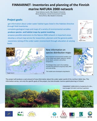
Target areas
FINMARINET (2009-2013) is funded by EU Life+,
total budget 3,4 milj €, and has 5 partners
The project will produce a vast amount of new information about the under-water world of the northern Baltic Sea. This
information serves, not only the specific goals of the project, but also broader marine spatial planning in Finland.
New information on
species distribution maps:
Most important environmental variables used
in the models were depth, exposure, salinity,
Secchi depth, nutrients and surface
temperature.
The biological data used in the modeling
included data gathered using drop-video, ROV
and scuba-diving.
The models were developed using MaxEnt.
Target area 6
Metsähallitus 2011
M. Westerbom Metsähallitus 2011 H. Arponen Metsähallitus 2008
Target area 4
M. Westerbom MH 2011