
Recommended
More Related Content
What's hot
Similar to Roadtrip Highlights Along US-30, the Lincoln Highway
Similar to Roadtrip Highlights Along US-30, the Lincoln Highway (20)
More from Donald Dale Milne
More from Donald Dale Milne (14)
Recently uploaded
Recently uploaded (20)
Roadtrip Highlights Along US-30, the Lincoln Highway
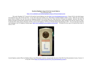
- 1. Roadtrip Highlights Along US-30, The Lincoln Highway By Donald Dale Milne https://www.roadtrip62.com/roadtrip-highlights-along-us-30-lincoln-highway.htm This week, Roadtrip-’62 ™ travels US-30 and the Lincoln Highway (see also https://www.lincolnhighwayassoc.org/ ). Route US-30 is the third longest US-numbered route, after US-20 and US-6. It runs 3073 miles from Atlantic City, New Jersey to Astoria, Oregon: ocean to ocean. While the east end has always been in Atlantic City, the west end was originally intended to be in Salt Lake City, Utah when the US system was planned. However, the states of Oregon and Idaho protested their proposed route of US-20 because it went through Yellowstone National Park, which charged a toll and was closed in winter. To provide those states with an all-season, toll-free coast-to-coast highway, US-30 was relocated during final planning in 1927. You can read more about the route planning at my US Highway Systems page, https://www.roadtrip62.com/us-highway-systems.htm . It became the first route to be paved from coast to coast, in 1935. Lincoln Highway marker (Photo by Matthew Bisanz, from Wikimedia Commons, licensed under the terms of the GNU Free Documentation License, Version 1.2 or any later version (https://en.wikipedia.org/wiki/GNU_Free_Documentation_License ).
- 2. The route’s association with the Lincoln Highway also goes back to that original planning, and as a consequence, US-30 from Atlantic City to Granger, Wyoming follows that route. The Lincoln Highway continues southwest from there to San Francisco, California instead of following US-30. We have crossed US-30 on our US-23 trip in mid Ohio at Upper Sandusky and Marion (see https://www.roadtrip62.com/us-23-day-7-fostoria-oh-delaware-oh.htm ). We also crossed it twice on our US-6 trip. Once at Joliet, Illinois and once beginning at Council Bluffs, Iowa through Omaha, Nebraska. Atlantic City, New Jersey in 1962 (postcard from an online auction) If you’re looking for history in Atlantic City, New Jersey, the famous board game of Monopoly was designed around the streets of Atlantic City. Highway US-30 begins near the Boardwalk and you can see other well-known streets nearby, including Tennessee Avenue, Vermont Avenue, other streets named after states, Atlantic Avenue, Mediterranean Avenue, and the railroads that once came here like Reading Railroad and B&O Railroad. If you’re looking for 1962 history here, look no further than the Ash Wednesday Storm, a violent and destructive storm of March 7, 1962. It affected the coast from Florida to New England, smashing 45,000 buildings and killing 32 people in New Jersey alone. Most of the hotels in Atlantic City were flooded and it even destroyed the weather recording equipment on the Steel Pier! I have more information on the storm in the Front Page News of March 10, 1962 page (see https://www.roadtrip62.com/ front-page-news-031014.htm ).
- 3. Detail from “The Gates of Hell”, Rodin Museum, Philadelphia, Pennsylvania (Photo by bobistraveling at Flickr (see https://www.flickr.com/photos/bobistraveling/ ), licensed under Creative Commons Attribution 2.0 Generic License (see https://creativecommons.org/licenses/by/2.0/ ).) The Lincoln Highway and US-30 run through the center of Philadelphia, Pennsylvania, crossing the tree-lined Benjamin Franklin Parkway. This street is the home of some of Philadelphia’s best cultural tourist attractions and I spent several days there on one vacation. The star attraction is The Franklin Institute (see https://www.fi.edu/ ), one of the oldest centers of science education and development in the country. It was founded in 1824 and has become the most visited museum in Pennsylvania! The current science museum building dates from 1934, so we could have seen it on a 1962 roadtrip. There have since been several remodelings and additions, and the institute now contains more than 400,000 square feet of exhibit space, the Tuttleman IMAX Theater, the Benjamin Franklin National Memorial, and the Fels Planetarium, the second oldest planetarium in the Western Hemisphere. You can easily spend a whole day at the science and technology exhibits. Other places to visit line the Benjamin Franklin Parkway from City Hall to the Philadelphia Museum of Art, including Swann Memorial Fountain, Cathedral Basilica of Saints Peter and Paul, the Rodin Gardens and Museum, and the Parkway Central Library. You can even make your own run up the “Rocky” steps at the Philadelphia Museum of Art! Besides The Franklin Institute, my favorite is the Rodin Museum and Gardens (see http://www.rodinmuseum.org/ ). The museum opened in 1929. The entire museum is a tribute to the late 19th-century French sculptor Auguste Rodin and includes nearly 150 bronze, marble, and plaster statues, such as The Thinker, and related materials such as studies for them. The adjacent Rodin Gardens provide a lovely and calm distraction from the stress of the city.
- 4. Andy Warhol Museum, Pittsburgh, Pennsylvania (Photo by Wally Gobetz at Flickr (see https://www.flickr.com/photos/wallyg/ ), licensed under Creative Commons Attribution-NonCommercial-NoDerivs 2.0 Generic License (see https://creativecommons.org/licenses/by-nc-nd/2.0/deed.en ).) As US-30 is a transcontinental highway, many of my other roadtrip pages have mentioned cities and attractions along the route. Gettysburg National Military Park, at Gettysburg, Pennsylvania, was covered when I discussed highway US-15 (at https://www.roadtrip62.com/roadtrip-highlights-of-us- 15.htm#Gettysburg ). The Fort Pitt Bridge, in Pittsburgh, Pennsylvania was discussed when my US-22 trip went through that city (at https://www.roadtrip62.com/postcards-from-1962-along-us-22.htm ). And I also wrote about the Andy Warhol Museum of the same city after I made a visit there (at https://www.roadtrip62.com/front-page-news-111813.htm#Warhol ). Artist Andy Warhol is uniquely tied to 1962 as he had his first showing of his Campbell's Soup Cans on July 9, 1962. More notably, we crossed two parts of US-30 on our US-23 roadtrip: US-30N at Upper Sandusky, Ohio and US-30S at Marion, Ohio. Upper Sandusky still has a section of the Lincoln Highway paved in brick, only 16-feet wide. In 1962, US-30 traveled two paths through much of Ohio, but has since been reduced to a single route approximately along old US-30N. You can read about that at https://www.roadtrip62.com/ https://www.roadtrip62.com/us-23-day-7-fostoria-oh-delaware-oh.htm#Marion . Sometimes several cities wanted to be on a particular numbered route, even though they were located along two parallel roads. The solution adopted was to split routes, creating for such roads as US-30N and US-30S. These divided routes were not popular even after adoption though, as AASHTO (the organization governing US highway route numbers) has been trying to eliminate them since 1934.
- 5. Grave of Johnny Appleseed (John Chapman), Fort Wayne, Indiana (postcard from an online auction) If you’re driving across Indiana on US-30, a pleasant afternoon can be spent at the Fort Wayne Children’s Zoo (see https://kidszoo.org/ ). This zoo had its beginning in 1952 as a nature preserve, but in 1962 planning began to turn it into a full-fledged zoo. I opened three years later and has been expanded since. Today it has everything from a Canadian lynx to a Sumatran orangutan to a Madagascar giant tortoise. Also in Fort Wayne is the grave of Johnny Appleseed. Born John Chapman, he spent nearly 48 years planting apple orchards throughout Pennsylvania, Ohio and Indiana. At the time of his death in 1845, near Fort Wayne, one of his orchards contained 15,000 apple trees! He is buried in Johnny Appleseed Memorial Park in a fenced-in plot. Continuing west into Illinois, though US-30 never enters Chicago, it gets close enough that it was also given an alternate route, US-30ALT, to connect to the city. This no route longer exists, and US-30 uses its old route through Joliet, Illinois. There, it crosses the most famous US-numbered highway of all, Route 66. It also crosses US-6, so I covered Joliet on two pages of that roadtrip beginning at https://www.roadtrip62.com/us-6-day-18-nappanee-in-joliet-il.htm#Joliet .
- 6. Viewing area, Palisades-Kepler State Park, Iowa (Photo by Iowa Department of Natural Resources at Flickr (see https://www.flickr.com/people/iowadnr/ .) A wonderful spot to hike along US-30 in Iowa is Palisades-Kepler State Park (see https://www.iowadnr.gov/Places-to-Go/State-Parks/Iowa-State- Parks/Palisades-Kepler-State-Park ). The park was established in 1922 and is home to the oldest trees in Iowa, the Eastern Red Cedar. Many can be found clinging to the limestone bluffs above the Cedar River. The trees in this area are estimated to be over 400 years old, with one dating back to 1523, according to core samples taken in the 1960s! You can see the trees and more along Cedar Cliff Trail, which is part of the 6-mile trail system. You will also see dramatic river bluffs, deep ravines, Indian mounds, and a large variety of wildflowers and wildlife. For non-hikers, the Cedar River offers excellent fishing for a variety of species, including channel catfish, bass and bluegills. Highway US-30 used to split again as it left Iowa, with a US-30ALT heading south to Omaha, Nebraska, while the main route crossed into Nebraska at Blair. Since 1969, only the main route remains. Speaking of Omaha, Nebraska in 1962, Roadtrip-'62 spends the entire day there for Day 25 of our US-6 trip at https://www.roadtrip62.com/us-6-day-25-council-bluffs-ia-omaha-ne.htm . What's left in Omaha from 1962? As usual, quite a bit, but quite a bit has been lost. We saw museums, a zoo, former industrial sites, and even a cathedral. Leaving Omaha, the Lincoln Highway and US-30 bumps up against The Platte River at Fremont, Nebraska for a long trip west along this broad, shallow, meandering river with a sandy bottom and many islands. The Platte River was one of the most significant rivers in the westward expansion of the United States, as it provided the route for several major emigrant trails, including the Oregon, California, Mormon, and Bozeman trails. The Pony Express mail route also used this river corridor. It seems a fitting route for a major transcontinental highway like the Lincoln Highway. Today, the I-80 freeway also travels this river route all the way west to Ogallala, Nebraska. Among several State Recreation Areas and State Historic Parks along the river, Fort Kearny State Recreation Area (see http://outdoornebraska.gov/fortkearnysra/ ) offers 186 acres of river bottom lands dotted with eight sandpit lakes. In the spring, the world's largest concentration of sandhill cranes and waterfowl gathers in the central Platte River valley. You can see them from the nature trails, along with some 100-year old cottonwood trees. And visit the historical exhibits at nearby Fort Kearny State Historical Park.
- 7. Sandhill Crane Migration on the Platte River, Nebraska (Photo by Larry Crist, US Fish and Wildlife Service, licensed under Creative Commons Attribution 2.0 Generic License (see https://creativecommons.org/licenses/by/2.0/ ).) At Ogallala, US-26 heads northwest and you can read about that route (at https://www.roadtrip62.com/roadtrip-highlights-along-us-26.htm ) and its journey to the Pacific Ocean, where US-30 will meet it again. In Wyoming, US-30 crosses through the Great Divide Basin, an area that does not drain either to the Atlantic Ocean or Pacific Ocean. The basin is a high, dry desert with sand dunes in its central western part. A monument to Henry B. Joy, the first president of the Lincoln Highway Association, was placed here, at what was once thought to be a crossing of the Continental Divide, but was later moved to nearby Sherman Summit. Antelope are all over the Red Desert, which is one of the most important pronghorn antelope ranges in the state. Near the west edge of Wyoming, US-30 again splits into two parts. The old US-30S went southerly to Ogden, Utah, while US-30N headed northwesterly to Pocatello, Idaho. They rejoined near Burley, Idaho, but US-30S has been decommissioned and replaced by the I-84 freeway.
- 8. Shoshone Falls, Twin Falls, Idaho (Photo by Frank Schulenburg via Wikimedia Commons, licensed under the Creative Commons Attribution-Share Alike 4.0 International license (see https://creativecommons.org/licenses/by-sa/4.0/deed.en ).) Through Idaho, US-30 largely follows the Snake River, and passes by several waterfalls. First up was American Falls, at the city of the same name. Unfortunately, this falls no longer exists, as it was obliterated in 1925 when the American Falls Dam was constructed to provide power for the area. This dam also inundated to city of American Falls, which was moved. The old townsite sits at the bottom of the reservoir, northwest of the present city. Only the Oneida Milling and Elevator Company’s grain elevator remains in its original location, with part of it above water. At the city of Twin Falls, Idaho, Shoshone Falls still exists, and at 212 feet high it’s 45 feet higher than Niagara Falls. That makes it high enough to form the upper limit of fish migration, including salmon, in the Snake River. In summer months, you will see a much smaller flow than historically, because a dam above the falls diverts most of the water to irrigation uses.
- 9. In Oregon, US-30 travels through the Columbia River Gorge, providing roadtrip travelers with spectacular scenery of cliffs, waterfalls, dense vegetation, and beautiful old concrete arch bridges. Emerging from the gorge at Astoria, Oregon, the landmark Astoria Column is a fitting endpoint for the highway (see http://astoriacolumn.org/ ). This historic column provides a panoramic view from the top of the splendor of the Pacific Ocean, the Columbia River, and the Coast Range of mountains. The monument was dedicated in 1926, and is located just a few blocks from the end of US-30, so we could have visited in 1962. The Astoria Column is one of a planned group of monuments along the highway, of which few were built. The monument stands 600 feet above sea level and was modeled after the Trajan Column in Rome. It features a hand-painted spiral frieze on the exterior, and a spiral staircase on the interior. Italian artist Attilio Pusterla created the exterior decorations using a method called sgraffito, commemorating the historic events that occurred at the mouth of the Columbia River. That brings us to the end of US-30, so I’ll see you soon on another Roadtrip-’62 ™ journey. Astoria Column, Astoria, Oregon (Photo by Another Believer at Wikimedia Commons (see http://commons.wikimedia.org/wiki/User:Another_Believer ), licensed under the Creative Commons Attribution-Share Alike 3.0 Unported license (see http://creativecommons.org/licenses/by-sa/3.0/deed.en ).)
- 10. Visit ROADTRIP-'62 ™ ( https://www.roadtrip62.com/index.htm )for more articles. Or visit us on Facebook https://www.facebook.com/pages/Roadtrip62/119235794845685 , Pinterest https://www.pinterest.com/roadtrip62/ , or Flickr https://www.flickr.com/photos/67972937@N07/page1 . Author of Roadtrip-'62TM ( https://www.roadtrip62.com/ ), Donald Dale Milne If you haven’t heard of nor Roadtrip-'62 ™ , my name is Don Milne and I'll be your travel guide on this virtual tour of the U. S. of A. First, I suppose you're wondering why nor Roadtrip-'62 ™ is different from other travel sites? There's a very simple answer: everybody else travels only in space, but we also travel in time! That's right, we don't just go somewhere, we also go somewhen. And the when is 1962. We'll try to see what's left today from 1962, by driving as if it were 1962. We will drive on highways as they were in 1962, try to eat only at restaurants that existed in 1962, try to stay only at motels that existed in 1962, try to buy gas and sundries, play the music, see only the sites across America, and just generally live in America as it was in 1962! What we will do is enjoy the FUN of cross-country driving. And the fun of cross-country travel is all the differences from our everyday life! We'll talk about politics, food, great inventions, how people lived, television, and more. We'll get to see some of the people that made our history; that made this country great. We'll stumble across unexpected pleasures, like one trip I made through Cherokee, North Carolina where I just happened to be in town as the 1996 Olympic Torch procession came through on it's way to Atlanta, Georgia. You really never know what you'll find when you travel!
- 11. 1962-style US-23 signs Now, let's see where we'll be going! We're going to drive the US-numbered routes of 1962. Because we'll be using the roads of 1962, that means we won't be on freeways very much. There weren't many freeways in 1962, as the country had just begun building the Interstate system,, so we'll travel mostly the two-lanes through every little town on the way. Sometimes even where there was a freeway, I'll go back on the old road just to see what was there. Anyway, even if there was a freeway in 1962, it was only there for a couple of years and things had not changed much. Sometimes a "business route" ran through a town on the old route, because there were no services at the freeway interchanges yet. Just in case you're asking why 1962, it's because I remember 1962. I traveled on my first freeway as a boy with my dad about that time, and fell in love with both travel and freeways. But, besides my own memories and the fact that it was a time largely before interstate freeways, 1962 is just cool...wait and see! And I'm writing this virtual tour just because I like to drive. I like to go places, see things, and just drive for the joy of driving! I decided I want to talk about it, to share the fun with others. I'll be doing the driving on our Roadtrip-'62 ™, but if you see anything you like, I encourage you to get out on the road and enjoy it in person. This virtual roadtrip may be fun, but there's nothing like the real thing!