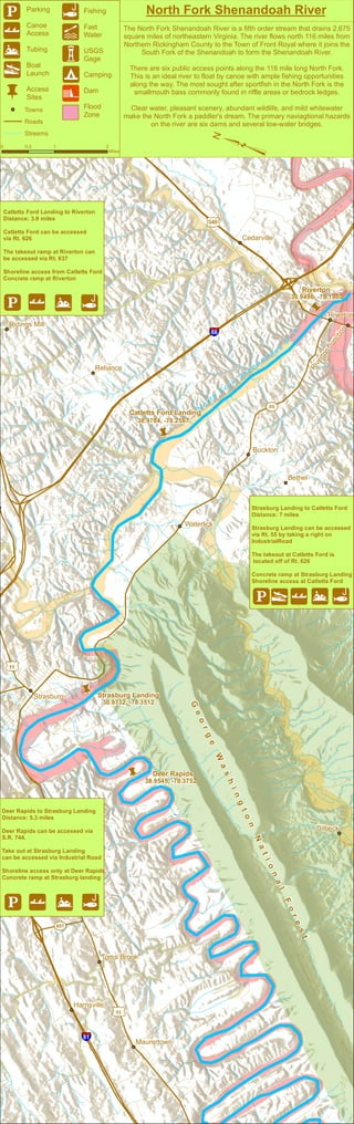
This document provides information about the North Fork Shenandoah River in Virginia, including details about six public access points along the 116-mile river. It describes the river as an ideal location for canoeing and fishing for smallmouth bass. The river flows north from Rickingham County to Front Royal and provides clear water, scenic views, and mild whitewater for paddlers, though six dams and some low bridges pose navigational hazards. Maps and information are given for three river sections between access points at Deer Rapids, Strasburg Landing, Catletts Ford, and Riverton.
Lake Lanier Waterfront Lot Sales Analysis 2014Arthur Prescott
A comparative market analysis of Lake Lanier waterfront lot sales for 2014. Provided by Arthur Prescott of Berkshire Hathaway HomeServices Georgia Properties.
www.LakeLanierLotsAndLand.com
www.LakeSidneyLanierHomes.com
Casa intelligente, ma Sensibile.
Smart House for... Non-Smart People.
Crediamo ci sia bisogno di:
- Essere Umano al centro della tecnologia;
- Interazione Uomo-Casa fruibile da tutti;
- Soluzioni con Costi alla portata di tutti.
P.S. Soltanto un'idea, fino a ieri!
P.S. Just an Idea, up until yesterday!
Please join us to discuss land use, natural resources, quality of life, economic development, and transportation issues in central Lake County.
YOUR input will help ensure that the Illinois Route 53/120 Corridor Land Use Plan will protect community assets – including vital natural resources and quality of life – and identify opportunities to improve recreation, increase access to transit, promote efficient and effective land use, and enhance economic development.
These slides give you an opportunity to explore workshop materials at your leisure.
The Frio Canyon is an outdoor explorers paradise. With the famous Frio River and two majestic state parks - Garner & Lost Maples - there is so much fun to be had. We invite you to come play, rest and relax in the beautiful Texas Hill Country.
This adventure guide will help you discover all there is to explore in the Frio Canyon. For more information about where to stay visit: www.riverbluffcabins.com .
The Redstone Run Highland Reserve comprises 8 acres at 25309 Highland Rd, Richmond Heights. Here, the stream cuts through the hard Euclid bluestone to create a small gorge in the softer shale below. The reserve conserves local nature and history. With it, the Friends of Euclid Creek can foster education and research on important watershed issues. Join us, Tuesday, May 6, 6:30 pm for a tour of the reserve with presentations by Roy Larick, Al Klonowski and Claire Posius.
to explore and plan.
A 6 day Inn to Inn bike tour on the Great Allegheny Passage and the C & O Canal towpath. Visit 3 national parks, and enjoy biking on 300 miles of vehicle free trail
Southern Traditions Outdoors September - October 2016Kalli Collective
Southern Traditions Outdoors is a free publication providing articles, photography, and places of interest for the outdoor sportsmen in the mid-south. Publications are printed every two months: Jan/Feb, March/April, May/June, July/Aug, Sept/Oct and Nov/Dec, and include articles on hunting, fishing and the outdoors. You can always find sections dedicated to children, veterans, women, and the physically challenged in our publication encouraging outdoor participation. You can find our publication throughout Tennessee, Missouri, Mississippi, Arkansas and Kentucky at any of our advertisers as well as many marinas, vehicle and ATV dealers, TWRA license agents, resorts and outdoor related retailers.
1. Shenandoah Shores
Riverton
38.9496, -78.1980
N o r t h F o r k S h e n a n d o a h R i v e r
Catletts Ford Landing
38.9784, -78.2587
Strasburg Landing
Ashby
b
Bethel
Success
Nineveh
Riverton Junction
Dilbeck
Rockland
Buckton
Riverton
Reliance
Waterlick
Strasburg
Cedarville
Toms Brook
Maurertown
Harrisville
Ridings Mill
G e o r g e W a s h i n g t o n N a t i o n a l F o r e s t
Sources: Esri, USGS, NOAA
b
b
38.9732, -78.3512
b Deer Rapids
38.9545, -78.3752
§¨¦66
§¨¦81
55
£¤340
£¤11
£¤11
651
North Fork Shenandoah River
The North Fork Shenandoah River is a fifth order stream that drains 2,675
square miles of northeastern Virginia. The river flows north 116 miles from
Northern Rickingham County to the Town of Front Royal where it joins the
South Fork of the Shenandoah to form the Shenandoah River.
There are six public access points along the 116 mile long North Fork.
This is an ideal river to float by canoe with ample fishing opportunities
along the way. The most sought after sportfish in the North Fork is the
smallmouth bass commonly found in riffle areas or bedrock ledges.
Clear water, pleasant scenery, abundant wildlife, and mild whitewater
make the North Fork a paddler's dream. The primary naviagtional hazards
on the river are six dams and several low-water bridges.
!j
!|
!s
!yb
Parking
Canoe
Access
Tubing
Boat
Launch
Access
Sites
!l
!z
!A
!9
!n
Fishing
Fast
Water
USGS
Gage
Camping
Dam
Flood
Zone
Towns
Roads
Streams
0 0.5 1 2
Miles
Catletts Ford Landing to Riverton
Distance: 3.9 miles
Catletts Ford can be accessed
via Rt. 626
The takeout ramp at Riverton can
be accessed via Rt. 637
Shoreline access from Catletts Ford
Concrete ramp at Riverton
!j !| !s !l
³
Strasburg Landing to Catletts Ford
Distance: 7 miles
Strasburg Landing can be accessed
via Rt. 55 by taking a right on
IndustrialRoad
The takeout at Catletts Ford is
located off of Rt. 626
Concrete ramp at Strasburg Landing
Shoreline access at Catletts Ford
!j!y!|!s!l
Deer Rapids to Strasburg Landing
Distance: 5.3 miles
Deer Rapids can be accessed via
S.R. 744.
Take out at Strasburg Landing
can be accessed via Industrial Road
Shoreline access only at Deer Rapids
Concrete ramp at Strasburg landing
!j !| !s !l