
Recommended
More Related Content
Similar to Rivers and Bridges - Konigsberg-Kalingrad
Similar to Rivers and Bridges - Konigsberg-Kalingrad (12)
More from ssuserb83554
Recently uploaded
Recently uploaded (20)
Rivers and Bridges - Konigsberg-Kalingrad
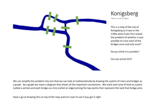
- 1. Konigsberg Rivers and Bridges This is a map of the city of Konigsberg as it was in the 1700s when Euler first solved the problem of whether it was possible to cross each of the bridges once and only once? Do you think it is possible? Can you prove this? We can simplify this problem into one that we can look at mathematically by drawing the system of rivers and bridges as a graph. By a graph we mean a diagram that shows all the important connections. We mark each area of land as a point (called a vertex) and each bridge as a line (called an edge) joining the two points that represent the land that bridge joins. Have a go at drawing this on top of the map and turn over to see if you got it right.
- 2. Here is what the graph looks like on top of the map. Because we have all the important information, we can move the vertices and edges around as much as we like and the graph is the same so long as we don’t add or remove edges or vertices. Over the last 300 years bridges have been removed and added to the city which is now called Kalingrad, do you think this changes whether the problem is possible? Try drawing a graph of this new version of the problem Can you spot any requirements for a path to be possible?