projet d'adduction de l'eau realisé par assamba ekamba
•
0 likes•69 views

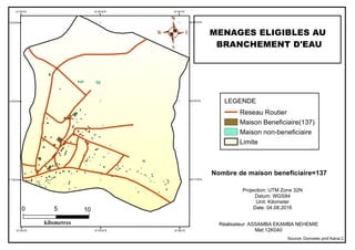
The document contains geographic coordinates and a map showing 137 homes designated as eligible to receive water connections, along with non-eligible homes and roads, with a total project area of approximately 105 square kilometers. The map legend defines symbols for eligible and non-eligible homes, roads, and boundaries, and provides information on the map projection and date of creation.
Recommended

More Related Content
What's hot
Recently uploaded
Recently uploaded (20)
projet d'adduction de l'eau realisé par assamba ekamba
- 1. 10°36'0"E 10°36'0"E 10°35'30"E 10°35'30"E 10°35'0"E 10°35'0"E 5°8'30"N 5°8'30"N 5°8'0"N 5°8'0"N 5°7'30"N 5°7'30"N . 0 105 kilometres Nombre de maison beneficiaire=137 MENAGES ELIGIBLES AU BRANCHEMENT D'EAU LEGENDE Reseau Routier Maison Beneficiaire(137) Maison non-beneficiaire Limite Projection: UTM Zone 32N Datum: WGS84 Unit: Kilometer Date: 04.08.2016 Réalisateur: ASSAMBA EKAMBA NEHEMIE Mat:12K040 Source: Donnees prof Kana.C