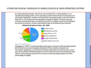
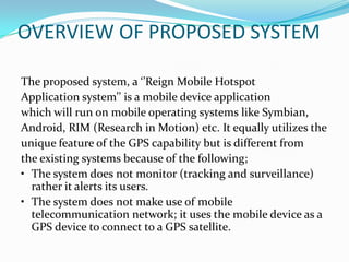
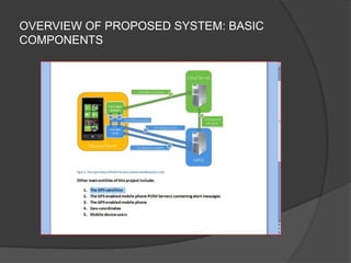
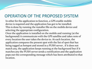
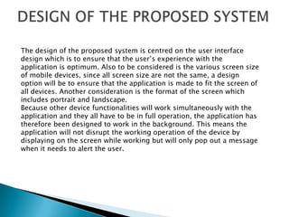
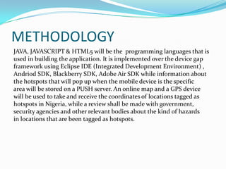
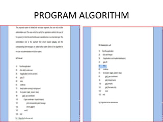
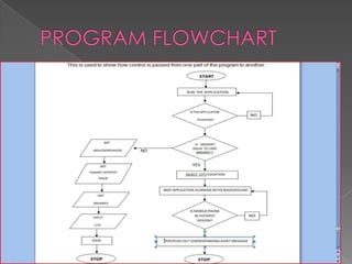
This document outlines a presentation on the Reign Mobile Hotspot Detection System project. The project aims to develop a mobile application to alert users about hazardous areas in Nigeria, such as areas prone to accidents, flooding, or crime. It will use the GPS location of the user's mobile device to check if they are entering a dangerous area and send a notification. The presentation covers the problem statement, objectives, literature review on GPS and mobile devices, proposed system design, methodology using Java and HTML5, and preliminary findings from testing in Nigeria.
Personal Security Tracking based on Android and Web ApplicationTELKOMNIKA JOURNAL
Nowadays, the frequency of abduction is increasing significantly. Information technology provide
many social media which is causing the leaked of personal information where abductor can find out the
information. Using social media, people can share location, life event, and anything related about their life
event, these become the useful information for the abductor. To anticipate this, a lot of personal tracking
device is developed, but the response is too late. Because, the family or relative of the victims will notice
that abduction had happen after the victim is lost. According to the problem, this research will focus on
develop the personal tracking device which trigger by the victims who own the phone based on android
and web application. Whenever the abduction happens, the victim just need to click the button and the
system will send a message to the relatives and family in their contact also trigger the notification to the
local security. Software development life cycle that will be used is scrum which is divided into several
processes like backlog, sprints, scrum meetings, and demos. The result of this research is android
application for user and web application for managing application.
Social App - Concept - Women Safety - (India)
Like the idea - buy a book for me?
http://www.amazon.in/registry/wishlist/288G2K0JZQOD6
http://flipkart.com/wishlist/b3naam
Geo location based augmented reality applicationeSAT Journals
Abstract As the inception of mobile app development began, various applications of Augmented Reality that was once only restricted under the avenue of personal computers extended its domain to mobile applications and currently is used in the wide fields of gaming, education, navigation and so on. The exceptional data processing abilities which is possessed by smartphones in concert with its various services such as Global Positioning System (GPS), wireless networks, and compass have authorized Augmented Reality to find a very fruitful proposition in the wide spectrum of navigation based apps. The objective of the proposed work is to structure and design Geo based Augmented Reality application using GART toolkit. The paper initiates with explaining the various components used in a Geo AR app, exploring and explaining the various structure and features of the app and providing a spotlight on the deficiencies and future scope of the targeted developed app [1]. Keywords: Augmented Reality, Global Positioning System, Wireless Network, GART, Geo AR app
Mobile Device Application to locate an Interest Point using Google MapsEditor IJCATR
Location-based service is a service mechanism that generates geographical location information. This service will certainly
give much benefit as there are many people who would like to find public facilities quickly and easily. The needs to know the
existence of public facilities quickly and easily is of great demands in the society. Based on the above problems, it is necessary to
develop an application that can get any access to the geographical location in mobile phones. Information from this application is
expected to help searching for such public facilities. This Searching for interest point information was read using the Location API in
Xcode IOS 4.2. The resulting information was displayed on the application of the iPhone. From the test results, the information of the
position was influenced by the availability of the information service provider, carrier signal strength, and mobile phone capabilities.
IEEE PROJECT TOPICS & ABSTRACTS BY SOFTRONIICSaswin tbbc
Location based intelligent mobile organizer
Our Project Guidance Methods
We are following Waterfall Methodology for Project development and condition and it has been strictly followed by each guiding staffs and we have better knowledge in this field and updated with new innovative technologies. Our past students have found project work at our centers as a reliable, efficient, inexpensive and a fruitful learning experience. We provide Students about their project at various stages of their project through regular classes and also through detailed technical documentation that we provide in digital format.
Softroniics head the group of companies forwarding technical project guidance assistance by counting the creative levels exhibited and innovations offered by the team while delivering their services. Technical training obtainable at Softroniics often finds its sturdy capability of having immense experience in the sector they play; competitors remain far behind as satisfied students are the strongest strength of marketing as well as expansion of team Softroniics.
for more details..... contact us..........
softroniics
calicut || palakkad || coimbatore
9037061113 , 9037291113
www.softroniics.in
Java based project ideas from softroniics
1. www.softroniics.in CALICUT || PALAKKAD Call: 9037291113 1. Aero Shuttle 2. Almanac Ascertain 3. Appositeness Intendance 4. Baccalaureate Gateway 5. Barristerial Atrium 6. Belligerent Tackle Hire Classification 7. Bistro Stipulation 8. Blemish Ascertainers 9. Bureaucrat Defended Entity 10. Cartel Communique 11. Cast Your Referendum 12. Clodhopper's Pal 13. Communal Contact_Abstract 14. Confrontation Reconnoiter 15. Convertible Leaflet Governance Explication 16. Digital Placard
2. www.softroniics.in CALICUT || PALAKKAD Call: 9037291113 17. Disburse Mobile Scheme 18. Disposition Prospectus 19. e-Acquirements 20. E-Chain Communicator 21. E-Conscription 22. Electorate Conspiracy 23. Endowment Fathom 24. Enormous Employment 25. First-Rate Sanatorium 26. Grime Dissolution Scheme 27. Haulable Overhaul 28. Infobahn Vendue 29. Inure-Avocation Unit 30. Menage Swop 31. Misdemeanor Abjurer 32. Mobility Bill Defrayment
3. www.softroniics.in CALICUT || PALAKKAD Call: 9037291113 33. Mortgage Scheme 34. Online Allegation 35. Online Burgeons Exposition 36. Online Dodge-ABS 37. Online Fretfulness 38. Online Itemization Structure 39. Online Nuptial 40. Online Symphony 41. Online Women Kibitzer 42. Ostentatious Storehouse Structure 43. Panchayathi Financial Aid 44. Paraquat Stockpile 45. Pragmatic Academy 46. Reckoning Inquisitor 47. Relevance to Scattered Precinct 48. Rescue Squad Overhaul Contributor
4. www.softroniics.in CALICUT || PALAKKAD Call: 9037291113
Technology which uses the physical location of the end-user to improve the relevance, context, and value of an application is defined as location based technology. Bluetooth, GPS, Wi-Fi and NFC are all location-based technologies. A service or application which utilizes location-based technology is called Location-based service(LBS).
The goal of this project is to provide a location-based alarm system through which users can broadcast their last known
position in emergency situations. The system will be able to send an SMS or an e-mail containing the user’s location coordinates
to the already registered mobile numbers using GCM service. The location information is obtained using GPS
technology and real-time location is shown on the receiver’s application using Google Maps API. In situations where GPS is
not available, the system tracks location using LBS technology
.Keywords: GPS,GCM,LBS Android.
IOSR Journal of Computer Engineering (IOSR-JCE) is a double blind peer reviewed International Journal that provides rapid publication (within a month) of articles in all areas of computer engineering and its applications. The journal welcomes publications of high quality papers on theoretical developments and practical applications in computer technology. Original research papers, state-of-the-art reviews, and high quality technical notes are invited for publications.
LF Energy Webinar: Electrical Grid Modelling and Simulation Through PowSyBl -...DanBrown980551
Do you want to learn how to model and simulate an electrical network from scratch in under an hour?
Then welcome to this PowSyBl workshop, hosted by Rte, the French Transmission System Operator (TSO)!
During the webinar, you will discover the PowSyBl ecosystem as well as handle and study an electrical network through an interactive Python notebook.
PowSyBl is an open source project hosted by LF Energy, which offers a comprehensive set of features for electrical grid modelling and simulation. Among other advanced features, PowSyBl provides:
- A fully editable and extendable library for grid component modelling;
- Visualization tools to display your network;
- Grid simulation tools, such as power flows, security analyses (with or without remedial actions) and sensitivity analyses;
The framework is mostly written in Java, with a Python binding so that Python developers can access PowSyBl functionalities as well.
What you will learn during the webinar:
- For beginners: discover PowSyBl's functionalities through a quick general presentation and the notebook, without needing any expert coding skills;
- For advanced developers: master the skills to efficiently apply PowSyBl functionalities to your real-world scenarios.
Key Trends Shaping the Future of Infrastructure.pdfCheryl Hung
Keynote at DIGIT West Expo, Glasgow on 29 May 2024.
Cheryl Hung, ochery.com
Sr Director, Infrastructure Ecosystem, Arm.
The key trends across hardware, cloud and open-source; exploring how these areas are likely to mature and develop over the short and long-term, and then considering how organisations can position themselves to adapt and thrive.
Elevating Tactical DDD Patterns Through Object CalisthenicsDorra BARTAGUIZ
After immersing yourself in the blue book and its red counterpart, attending DDD-focused conferences, and applying tactical patterns, you're left with a crucial question: How do I ensure my design is effective? Tactical patterns within Domain-Driven Design (DDD) serve as guiding principles for creating clear and manageable domain models. However, achieving success with these patterns requires additional guidance. Interestingly, we've observed that a set of constraints initially designed for training purposes remarkably aligns with effective pattern implementation, offering a more ‘mechanical’ approach. Let's explore together how Object Calisthenics can elevate the design of your tactical DDD patterns, offering concrete help for those venturing into DDD for the first time!
Securing your Kubernetes cluster_ a step-by-step guide to success !KatiaHIMEUR1
Today, after several years of existence, an extremely active community and an ultra-dynamic ecosystem, Kubernetes has established itself as the de facto standard in container orchestration. Thanks to a wide range of managed services, it has never been so easy to set up a ready-to-use Kubernetes cluster.
However, this ease of use means that the subject of security in Kubernetes is often left for later, or even neglected. This exposes companies to significant risks.
In this talk, I'll show you step-by-step how to secure your Kubernetes cluster for greater peace of mind and reliability.
GDG Cloud Southlake #33: Boule & Rebala: Effective AppSec in SDLC using Deplo...James Anderson
Effective Application Security in Software Delivery lifecycle using Deployment Firewall and DBOM
The modern software delivery process (or the CI/CD process) includes many tools, distributed teams, open-source code, and cloud platforms. Constant focus on speed to release software to market, along with the traditional slow and manual security checks has caused gaps in continuous security as an important piece in the software supply chain. Today organizations feel more susceptible to external and internal cyber threats due to the vast attack surface in their applications supply chain and the lack of end-to-end governance and risk management.
The software team must secure its software delivery process to avoid vulnerability and security breaches. This needs to be achieved with existing tool chains and without extensive rework of the delivery processes. This talk will present strategies and techniques for providing visibility into the true risk of the existing vulnerabilities, preventing the introduction of security issues in the software, resolving vulnerabilities in production environments quickly, and capturing the deployment bill of materials (DBOM).
Speakers:
Bob Boule
Robert Boule is a technology enthusiast with PASSION for technology and making things work along with a knack for helping others understand how things work. He comes with around 20 years of solution engineering experience in application security, software continuous delivery, and SaaS platforms. He is known for his dynamic presentations in CI/CD and application security integrated in software delivery lifecycle.
Gopinath Rebala
Gopinath Rebala is the CTO of OpsMx, where he has overall responsibility for the machine learning and data processing architectures for Secure Software Delivery. Gopi also has a strong connection with our customers, leading design and architecture for strategic implementations. Gopi is a frequent speaker and well-known leader in continuous delivery and integrating security into software delivery.
GraphRAG is All You need? LLM & Knowledge GraphGuy Korland
Guy Korland, CEO and Co-founder of FalkorDB, will review two articles on the integration of language models with knowledge graphs.
1. Unifying Large Language Models and Knowledge Graphs: A Roadmap.
https://arxiv.org/abs/2306.08302
2. Microsoft Research's GraphRAG paper and a review paper on various uses of knowledge graphs:
https://www.microsoft.com/en-us/research/blog/graphrag-unlocking-llm-discovery-on-narrative-private-data/
DevOps and Testing slides at DASA ConnectKari Kakkonen
My and Rik Marselis slides at 30.5.2024 DASA Connect conference. We discuss about what is testing, then what is agile testing and finally what is Testing in DevOps. Finally we had lovely workshop with the participants trying to find out different ways to think about quality and testing in different parts of the DevOps infinity loop.
Welocme to ViralQR, your best QR code generator.ViralQR
Welcome to ViralQR, your best QR code generator available on the market!
At ViralQR, we design static and dynamic QR codes. Our mission is to make business operations easier and customer engagement more powerful through the use of QR technology. Be it a small-scale business or a huge enterprise, our easy-to-use platform provides multiple choices that can be tailored according to your company's branding and marketing strategies.
Our Vision
We are here to make the process of creating QR codes easy and smooth, thus enhancing customer interaction and making business more fluid. We very strongly believe in the ability of QR codes to change the world for businesses in their interaction with customers and are set on making that technology accessible and usable far and wide.
Our Achievements
Ever since its inception, we have successfully served many clients by offering QR codes in their marketing, service delivery, and collection of feedback across various industries. Our platform has been recognized for its ease of use and amazing features, which helped a business to make QR codes.
Our Services
At ViralQR, here is a comprehensive suite of services that caters to your very needs:
Static QR Codes: Create free static QR codes. These QR codes are able to store significant information such as URLs, vCards, plain text, emails and SMS, Wi-Fi credentials, and Bitcoin addresses.
Dynamic QR codes: These also have all the advanced features but are subscription-based. They can directly link to PDF files, images, micro-landing pages, social accounts, review forms, business pages, and applications. In addition, they can be branded with CTAs, frames, patterns, colors, and logos to enhance your branding.
Pricing and Packages
Additionally, there is a 14-day free offer to ViralQR, which is an exceptional opportunity for new users to take a feel of this platform. One can easily subscribe from there and experience the full dynamic of using QR codes. The subscription plans are not only meant for business; they are priced very flexibly so that literally every business could afford to benefit from our service.
Why choose us?
ViralQR will provide services for marketing, advertising, catering, retail, and the like. The QR codes can be posted on fliers, packaging, merchandise, and banners, as well as to substitute for cash and cards in a restaurant or coffee shop. With QR codes integrated into your business, improve customer engagement and streamline operations.
Comprehensive Analytics
Subscribers of ViralQR receive detailed analytics and tracking tools in light of having a view of the core values of QR code performance. Our analytics dashboard shows aggregate views and unique views, as well as detailed information about each impression, including time, device, browser, and estimated location by city and country.
So, thank you for choosing ViralQR; we have an offer of nothing but the best in terms of QR code services to meet business diversity!
Dev Dives: Train smarter, not harder – active learning and UiPath LLMs for do...UiPathCommunity
💥 Speed, accuracy, and scaling – discover the superpowers of GenAI in action with UiPath Document Understanding and Communications Mining™:
See how to accelerate model training and optimize model performance with active learning
Learn about the latest enhancements to out-of-the-box document processing – with little to no training required
Get an exclusive demo of the new family of UiPath LLMs – GenAI models specialized for processing different types of documents and messages
This is a hands-on session specifically designed for automation developers and AI enthusiasts seeking to enhance their knowledge in leveraging the latest intelligent document processing capabilities offered by UiPath.
Speakers:
👨🏫 Andras Palfi, Senior Product Manager, UiPath
👩🏫 Lenka Dulovicova, Product Program Manager, UiPath
The Art of the Pitch: WordPress Relationships and SalesLaura Byrne
Clients don’t know what they don’t know. What web solutions are right for them? How does WordPress come into the picture? How do you make sure you understand scope and timeline? What do you do if sometime changes?
All these questions and more will be explored as we talk about matching clients’ needs with what your agency offers without pulling teeth or pulling your hair out. Practical tips, and strategies for successful relationship building that leads to closing the deal.
The Art of the Pitch: WordPress Relationships and Sales
Project presentation2
1. REIGN MOBILE HOTSPOT DETECTION SYSTEM
Presented
by
Okafor Chukwuemeka. G.O
Department of Computer Science
Faculty of Science
University of Abuja.
2. Presentation Outline
• PROJECT DESCRIPTION
• STATEMENT OF PROBLEM
• AIM & OBJECTIVE OF THE RESEARCH
• LITERATURE REVIEW
• LITERATURE REVIEW: OVERVIEW OF THE GLOBAL POSITION SYSTEM (GPS)
• LITERATURE REVIEW: OVERVIEW OF MOBILE DEVICES & THEIR OPERATING SYSTEMS
• MOBILE APPLICATION ARCHITECTURE
• SYSTEM ANALYSIS & DESIGN
• SYSTEM ANALYSIS & DESIGN: REVIEW OF EXISTING MOBILE device GPS APPLICATION
• OVERVIEW OF PROPOSED SYSTEM
• OVERVIEW OF PROPOSED SYSTEM: BASIC COMPONENTS
• FEATURES OF THE PROPOSED SYSTEM
• OPERATION OF THE PROPOSED SYSTEM
• DESIGN OF THE PROPOSED SYSTEM
• METHODOLOGY
• PROGRAM ALGORITHM
• PROGRAM FLOWCHART
• TECHNOLOGY PLATFORM
• SOURCE OF DATA FOR THE PROPOSED SYSTEM
• FINDINGS & CONCLUSIONS
• BIBLOGRAPHY
• ACKNOWLEDGEMENT
3. PROJECT DESCRIPTION
Reign mobile hotspot detection system is a cross
platform application that is developed to help warn
its users of hostile areas (ie areas prone to accident,
flooding, kidnapping, civil unrest, bombings etc). It also
has functionalities that allow users to report hazardous
areas through a preconfigured e-mail which
includes the users current location, description of
the hazard they want to report amongst other details. It
was developed with HTML5 and JAVA programming
languages.
4. STATEMENT OF PROBLEM
The logic behind the creation of this application known as
“Reign” emanates from the belief that crimes, accidents or
hazards can be reduced or even prevented if the user is aware
that
a particular location is a hotspot. This project focuses on the
users(ie a traveller, foreigner, or one of the locals visiting
somewhere for the first time who is unaware of the dangers that
might be present) to law enforcement/policy makers
perspective,
as it involves notifying the user about the possibility of a
potential hazard/crime in their present location, so that they can
take proactive measures to avoid it. It also enables the user to
assist in combating crime/saving lives by reporting a crime,
5. AIM & OBJECTIVE OF THE RESEARCH
The focus of this research is to develop a mobile application
that will be capable of alerting users of crime and hotspots in
Abuja, the Federal capital of Nigeria as well as other parts of
the country. Objectives of this project include: to create an
awareness on the various kinds of hazards in different
locations and to help law enforcement agencies to be
informed and keep track of activities that are occurring in
various part of the capital that constitute danger, hazard or
accident to the environment. It will also alert users and law
enforcement agencies when an accident/hazards has occurred
in an area.
6. AIM & OBJECTIVE OF THE RESEARCH (Continued)
Also, we wanted to ascertain how mobile
computing through mobile applications, when
integrated with existing and emerging
technologies as experienced with developing and
developed nations, could contribute to national
development, foreign investment as well as help
address challenges that seem to defy
conventional means here in Nigeria
7. LITERATURE REVIEW
With the release of the GPS to the civilians by the United States military, the
Global Positioning Systems (GPS) and new breakthrough products are
constantly emerging on the market. The most recent breakthroughs are now
readily available to consumers in the form of vehicle navigation and
communication devices, theft protection and global surveillance.
Also since the technology breakthrough in mobile devices development
and better telecommunication networks, the mobile device has being
put into different use through the development of various kinds of
applications. This project is aimed at merging the advantages of both the GPS
and the mobile device to create an early warning system of hotspots
amongst other features in Nigeria.
8. LITERATURE REVIEW: OVERVIEW OF THE GLOBAL POSITION SYSTEM (GPS)
• The Global Positioning System (GPS) is a space-based
global navigation satellite system (GNSS) that provides
location and timely information in all weather, anywhere
on or near the Earth, as long as there is an unobstructed
line of sight to four or more GPS satellites. It is maintained
by the United States government and is freely accessible by
anyone with a GPS receiver ( Golab, 1996).
• The GPS project was developed in 1973 to overcome the
limitations of previous navigation systems, integrating
ideas from several predecessors, including a number of
classified engineering design studies from the 1960s. GPS
was created and realized by the U.S. Department of
Defence (USDOD) and was originally run with 24 satellites
(Burrows, 2003).
10. MOBILE APPLICATION ARCHITECTURE
A mobile application is normally structured as a multi-
layered application consisting of user experience,
business, and data layers. When developing a mobile
application, you may choose to develop a thin Web-based
client or a rich client. When building a rich client, the
business and data services layers are likely to be located
on the device itself. When building a thin client, the
business and data layers will be located on the server.
Figure 3.1 illustrates the common rich client mobile
application architecture with components grouped by
areas of concern (Dearen, 2009).
12. The proposed system is a mobile device application which is specially
designed to work with them Global Positioning System and to alert of the
possibility of danger whenever the user of the mobile device is in an area
which has already being tagged as black spot. Here we take a brief look at
similar existing systems, the working operations and how it is different from
the existing system, by giving an overview of the proposed system, describing the
working operations, analysis of it and the design. It is developed taking the following
assumptions into consideration:
• The GPS co-ordinates are accurate and are capable of locating various spots in
Nigeria.
• All information obtained about hotspots and the hazards that can be encountered
in these areas are precise.
• Mobile devices in which the application will be installed are GPS enabled which
includes Androids and Blackberry devices amongst others
• Mobile device communications with the GPS satellite does not result in erroneous
information.
13. SYSTEM ANALYSIS & DESIGN: REVIEW OF EXISTING MOBILE device GPS APPLICATION
Mobile device GPS applications exist in different
formats performing different functions. They could
be installed into the device by the manufacturer
from the factory or could be bought and installed in
the device as a third party application. Most of this
operation follows the same working principle which
originates from the unique capability of the GPS to spot
every location on the surface of the earth. It is from this
feature that tracking and surveillance (which are the two
main functions of a mobile GPS application) are achieved.
14. OVERVIEW OF PROPOSED SYSTEM
The proposed system, a ‘’Reign Mobile Hotspot
Application system’’ is a mobile device application
which will run on mobile operating systems like Symbian,
Android, RIM (Research in Motion) etc. It equally utilizes the
unique feature of the GPS capability but is different from
the existing systems because of the following;
• The system does not monitor (tracking and surveillance)
rather it alerts its users.
• The system does not make use of mobile
telecommunication network; it uses the mobile device as a
GPS device to connect to a GPS satellite.
16. FEATURES OF THE PROPOSED SYSTEM
The Reign Mobile Hotspot Application system which is capable
of warning user of the potential danger in specific locations
will bring another dimension to security and will be designed
with the following attributes:
• Ability to be installed on any GPS enabled mobile device.
• Ability to work at the background without disrupting other
functions of the device like GPRS, UTMS, 3G and other
network.
• Dynamic in nature, which will enable the updates of new
locations and type of hazards.
• Stores list of locations mapped into coordinates (latitude and
longitude) and their corresponding hazards on the PUSH
server.
17. OPERATION OF THE PROPOSED SYSTEM
In other for the application to function, a GPS enable mobile
device is required and the application has got to be installed.
This is done by running the installer file on the mobile device and
selecting the appropriate configuration.
Once the application is installed on the mobile and running (at the
background) it communicate with the GPS satellite and takes note of
every location the user takes the device to. At each location, the
application compares the present spot with the list of spot that has
being tagged as hotspot and stored in a PUSH server , if it does not
match any, the application keeps running at the background but if it
matches any the PUSH server sends a notification and the application
pops out the corresponding message which has been attributed to that
location.
18. The design of the proposed system is centred on the user interface
design which is to ensure that the user’s experience with the
application is optimum. Also to be considered is the various screen size
of mobile devices, since all screen size are not the same, a design
option will be to ensure that the application is made to fit the screen of
all devices. Another consideration is the format of the screen which
includes portrait and landscape.
Because other device functionalities will work simultaneously with the
application and they all have to be in full operation, the application has
therefore been designed to work in the background. This means the
application will not disrupt the working operation of the device by
displaying on the screen while working but will only pop out a message
when it needs to alert the user.
19. METHODOLOGY
JAVA, JAVASCRIPT & HTML5 will be the programming languages that is
used in building the application. It is implemented over the device gap
framework using Eclipse IDE (Integrated Development Environment) ,
Andriod SDK, Blackberry SDK, Adobe Air SDK while information about
the hotspots that will pop up when the mobile device is the specific
area will be stored on a PUSH server. An online map and a GPS device
will be used to take and receive the coordinates of locations tagged as
hotspots in Nigeria, while a review shall be made with government,
security agencies and other relevant bodies about the kind of hazards
in locations that are been tagged as hotspots.
22. TECHNOLOGY PLATFORM
JAVA:
Java is a programming language originally developed by James Gosling at Sun
Microsystems and released in 1995 as a core component of Sun Microsystems' Java
platform. The language derives much of its syntax from C and C++ but has a simpler
object model and fewer low-level facilities. Java applications are typically compiled to
byte code that can run on any Java Virtual Machine (JVM) regardless of computer
architecture.
HTML5 and CSS3:
HTML5 and CSS3 are emerging web technologies. They are making web applications
more interactive and feature-rich.
HTML5 has not only added new markups for more robust multimedia support; it has
also added features like web worker for background processing, offline support,
database support, and much more. CSS3 is the new standard for a seamless, rich User
Interface (UI)
23. TECHNOLOGY PLATFORM (Continued)
PHONEGAP:
PhoneGap is a HTML5 application framework that is used to develop native applications through
web technologies. This means that developers can develop Smartphone and Tablet applications
with their existing knowledge of HTML, CSS, and JavaScript. With PhoneGap, developers don’t
have to learn languages like Objective-C for the iphone. Applications that are developed using
PhoneGap are hybrid applications. These applications are not purely HTML/JavaScript based, nor
are they native. Parts of the application, mainly the UI, the application logic, and communication
with a server, is based on HTML/JavaScript. The other part of the application that communicates
and controls the device (device or tablet) is based on the native language for that platform.
PhoneGap provides a bridge from the JavaScript world to the native world of the platform, which
allows the JavaScript API to access and control the device (device or tablet). PhoneGap essentially
provides the JavaScript API with access to the device (device or tablet) capabilities like, the
camera, GPS, device information, and many others.
PUSH SERVICES:
PUSH services is an essential component of the real-time, always-on experience for mobile
devices. It offers an incredibly efficient and reliable way of sending information to your users. It
allows users to be alerted of new and current information right when it happens. It locates the
server using geolocation, goecoding or reverse geocoding in your application.
24. SOURCE OF DATA FOR THE PROPOSED SYSTEM
In order to make the system practical and adaptable to
real live situations, the source of data to be used must
be obtained from a reliable source. This was achieved
by collaborating with the local police and other
security/governmental agencies to obtain the pattern
and nature of hazards/crimes that can be encountered
in different locations over a specific period of time. It is
with this data that the accuracy of the system shall be
based on.
25. FINDINGS & CONCLUSIONS
Preliminary testing in Lagos, Abuja, and Ogun
states in Nigeria has shown precise and accurate
notification to the users of the application. It
also has been able to capture correctly threats,
users details and the precise location of the
threats that has been reported.
26. • http://www.devicegap.com
BIBLOGRAPHY
• http://www.andriod.com
• http://www.wikipedia.com
• http://www.mobilespoon.net/2011/10/how-do-push-notifications-work-non.html
• BAYLEY, D., AND CLIFFORD S. 1996. The Future of Policing. Law and Society Review. 30(3): 585-606.
• Crampton, Jeremy W. 1995. The ethics of GIS. Cartography and Geographic Information Systems 22, 84-89.
• DE WAARD, J. 1999. The Private Security Industry in International Perspective. European Journal on Criminal
Policy and Research 7(2): 143-174
• Jaishankar, K. (2001). Role of Global Positioning Systems (GPS) in Policing. The Asian GPS Conference.
• JOHNSTON, L. 1992. The Rebirth of PrivatePolicing. London: Routledge.
• Kelling, G., and M. Moore. 1987. “The Evolving Strategy of Policing.” Perspectives on Policing. 4(1): 1–15.
• Monmonier, Mark. 2002. Spying with Maps: Surveillance Technologies and the Future of Privacy. Chicago:
University of Chicago Press.
• NALLA, M. 1998. Opportunities in the Emerging Market. Security Journal 10: 15-21.
• Schuo, L. & Zhu, K. (2003). GPS Accuracy and Position Update Rate for Field Traffic Studies. ITE Journal 73(2),
p. F.
• SCHÖNTEICH, M. 2000. Fighting Crime With Private Muscle: The Private Sector and Crime Prevention.
www.iss.co.za/Pubs
• Rohit,G & Yogesh.P(2010). Beginning with devicegap. Apress publication:13-17
27. ACKNOWLEDGEMENT
I really want to give thanks to my family
members, members of the Nigerian Association of
Computer Science Students (NACOSS), and all my
friends for their support through out the course of this
project. Also, I will like to thank my supervisor Dr.
Olumide Owolabi for sharing his wealth of experience
with me, Micheal O. Ocheje and Omo for their
technical support. More importantly, I will like to thank
God Almighty for His grace and mercies upon my life.