The document discusses the development of an augmented reality application called "Taman Tamadun Islam Get-A-Way" to help tourists navigate places of interest in Taman Tamadun Islam. The application aims to address problems such as tourists being scammed or lacking information by providing navigation and building information using augmented reality. The development will use the ADDIE model and include marker-based and location-based augmented reality techniques. A proof of concept was created including a home page, guide page, and demonstrations of the augmented reality features. The expected results are an interactive application that enhances the tourism experience and provides precise information to users.
Location-aware and mapping applications have gone from a desirable feature to an essential
part of any smart phone. Whether a user is checking into a social network, looking for a
pharmacy in the middle of the night, or located in somewhere and needs help, the key is always
the same: location.
In this project, an Android mapping application is developed. The application is able to display
the map of the whole world while online or, display a pre-downloaded map while offline, track
the user’s location, display a compass to determine north, send the user’s location to others in
case of emergency using SMS, receive and interpret received location from the message, display
it on the map, and notify the user by the reception of the location.
The application was developed using agile methodology. It, met its objectives and successfully
passed 91% of the final system test, recording that some limitations were discovered, the
application needs further testing and can be implemented for particular company or university
using their own maps or editing the maps in OSM (open street maps).
Our framework for app success encompasses seven
dimensions, with relevance at the absolute heart.
We identified 6 additional factors that contribute to app
success, all centred around either enabling users or
focusing on the user themselves.
This presentation provides an insight into the technology used in location based services and also an overview of all the location based applications that are currently in the market.
In Open-RnD we always remember about users of the solutions that we are developing. Our clients can always count on our experience in making their products intuitive and easy to use.
Tripper is a product extension of the makemytrip company.
The app helps Create your travel plan and the daywise itinerary, sorts all tickets and data in one place, tracks you while you travel and as your trip ends it create a trip diary that you can edit and share with your friends and family.
Its is the one stop solution for all your travel needs. Travel hassle and carefree with the Tripper app.
View and download the ppt addressing the statistics of the usage of travel apps in the world and the 7 Must-Include Feature In Mobile Apps Taking The Travel Industry By Storm developed by codiant software technologies.
Sixth Sense is a wearable gestural interface that integrates digital information into the physical world and its objects, making the entire world your computer and lets us use natural hand gestures to interact with that information.
>DESCRIPTION:
Google Self-driving Cars are developed by Google [X] as part of its project to develop technology for mainly electric cars.
A Self-driving car (driver-less car, unmanned car, autonomous car, robotic car) is a vehicle that is capable of sensing its environment and navigating without human supervision or input. These modern cars are incorporated with finest features which allow them to operate autonomously.
Autonomous and unmanned technology is emerging gradually but continually, with new opportunities for its employment likely to follow in almost every industry which are involve in vehicle manufacturing like Ford, BMW, Audi etc.
Despite of the fact that this technology is emerging but autonomous and unmanned vehicles involve a transfer of control from direct human input to automated or self-control. This has implications for the determination of liability in the event of an incident, and will be a key factor in the pricing and risk transfer.
>MISSION:
According to Jennifer Haroon (Head of Business Operations - Google[X]):
“Our mission is to improve people’s life by transforming ability, and when we talk about transforming ability, one of the main part of that is “Safety”
>HISTORY:
The vision behind the Google Autonomous Cars was began as early as the 1939 New York World’s Fair where visitors were presented a vision of automated cars.
Another concept behind the “Google Driver-less Car” is the advertise from 1950’s showing a family on route trip.
>BEGINNING:
Numerous major companies and research organizations have developed working prototype autonomous vehicles, including Mercedes-Benz, General Motors, Continental Automotive Systems, IAV, Autoliv Inc., Bosch, Nissan, Renault, Toyota, Audi, Volvo, Tesla Motors, Peugeot, AKKA Technologies, Vislab from University of Parma, Oxford University and Google.
The reason behind the popularity of “Google Autonomous Vehicle” is because in May 2014, Google presented a new concept for their driver-less car that had neither a steering wheel nor pedals, and unveiled a fully functioning prototype in December of that year that they planned to test on San Francisco Bay Area roads beginning in 2015.
>TECHNOLOGY:
Google's robotic cars have about $150,000 in equipment. The software installed in Google's cars is named Google Chauffeur as well as including Lasers, Cameras, Radars, and Computing System that makes it into a “Self Driving Vehicle”
>SURVEY:
Expert members of the Institute of Electrical and Electronics Engineers (IEEE) have determined that driver-less vehicles will be the most viable form of intelligent transportation. They estimate that up to 75% of all vehicles will be autonomous by 2040.
International Journal of Engineering Research and DevelopmentIJERD Editor
Electrical, Electronics and Computer Engineering,
Information Engineering and Technology,
Mechanical, Industrial and Manufacturing Engineering,
Automation and Mechatronics Engineering,
Material and Chemical Engineering,
Civil and Architecture Engineering,
Biotechnology and Bio Engineering,
Environmental Engineering,
Petroleum and Mining Engineering,
Marine and Agriculture engineering,
Aerospace Engineering.
PRO-VAS: utilizing AR and VSLAM for mobile apps development in visualizing ob...TELKOMNIKA JOURNAL
The development of mobile apps with augmented reality (AR) would enhance the capability in visualizing the scene or environment. Any apps supported by computer aided design versions with 3D models makes the design more realistic, such as in the form of websites or mobile apps. However, the current features for online platforms for shopping are quite limited and lack 3D visualization features. This paper presents the development of a mobile application, pro-visualizer app called PRO-VAS, that utilizes AR for scanning and visualizing the environment. PRO-VAS acts as a product visualizer that applies visual simultaneous localization and mapping (VSLAM) for localization of the product in AR based systems.
The main components of PRO-VAS are ARCore from Google for interactive purposes, and the depth mapping from red green blue depth (RGB-D) phone camera with point plane generator and markerless tracking method. The last component of the app is the set of objects from the unity store, which can be chosen in PRO-VAS for the scanned scene area. The app was tested in various environments involving different objects and has shown competitive results. In the future, more features and products can be added to the apps.
How much would it cost to develop an indoor navigation app.pdfFuGenx Technologies
Well, the indoor positioning app technology helps businesses better so that they can take advantage of this service. They can use the Indoor Positioning & Navigation app to map large buildings such as malls, railways, and airports for visitors. Offices, malls, hospitals, airports, warehouses, and university campuses, all of these buildings are built on a large area, making it a challenge for visitors to quickly find their way.
VR Bukit Puteri is a project that focus in education. Virtual Reality Bukit Puteri can be used by student and community to provide a walking tour experience around Bukit Puteri. This application also developed to foster the spirit of love for historical heritage and also for learning history.
The Objective of the project is to explore junagadh city which develop on the Android platform, including a prototype of the city guide. The System, introduce with outstanding features like, User can get an information about city, User Can Register and Log in to application
Comparative study of user experience on mobile pedestrian navigation between ...IJECEIAES
Fast-paced mobile technology development has permitted augmented reality experiences to be delivered on mobile pedestrian navigation context. The fact that the more prevalent of this technology commonly will substituting the digital map visualization to present the geo-location information is still debatable. This paper comprises a report on a field study comparing about user experience when interacting with different modes of mobile electronic assistance in the context of pedestrian navigation interfaces which utilize location-based augmented reality (AR) and two-dimensional digital map to visualize the points of interest (POIs) location in the vicinity of the user. The study was conducted with two subsequent experiments in the Zhongli District, Taoyuan City, Taiwan. The study involved 10 participants aged between 22 and 28 years with different experiences in using smartphones and navigation systems. Navigation performance was measured based on a usability approach on pragmatic quality and hedonic quality like effectiveness (success rate of task completion), efficiency (task completion time) and satisfaction in real outdoor conditions. The evaluation findings have been cross-checked with the user’s personal comments. We aim at eliciting knowledge about user requirements related to mobile pedestrian interfaces and evaluating user experience from pragmatic and hedonic viewpoints. Results show that in the context of pedestrian navigation, digital map interfaces lead to significantly better navigation performance in pragmatic attributes in comparison to AR interfaces. Nevertheless, the study also reveals that location-based AR is more valued by participants in hedonic qualities and overall performance.
3. PROJECT
BACKGROUND
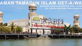
“Taman Tamadun Islam Get-A-Way” is an
application that navigate the tourist to the
interesting places around Taman Tamdun Islam
while implementing the current technology which is
“Augmented Reality (AR)” .This application also will
show them a little bit information about the building
when they point to any historic or the interesting
places around them.
4. PROBLEMS STATEMENT
Tourist who is on their own which means they are travelling alone
are prone to be scam by irresponsible person.
Tourist do not have the information about the places and the
information is hard to be search and sometimes the community
around the places also do not know about it.
Tourist may get bored as there is no interactive action during the tour
as the tourist just only will watch the monument around the Taman
Tamadun Islam.
5. To
desig
n
To
develop
To
test
An informative system that
helps the user or tourist enjoy
learning new stuff with new
way.
OBJECTIVES
The trustworthy of the
application and reducing the
probability of the tourists of
being scammed.
Application that will let the
tourist or user to interact with
their phone while enjoying
their tour.
6. User can search and navigate their way
through Kuala Terengganu city.
User can point their smartphones and get
information on certain building around the
Kuala Terengganu.
USER (TOURIST)
The application will show an arrow that will
navigate the way through the desired places.
When the smartphones are pointed to the
buildings, it will pop an information about the
buildings.
The application also required the use of internet
connection and Global Positioning System
(GPS).
APPLICATION
SCOPES
7. The application only available on outdoor environment only.
LIMITATION
OF WORKS
Only certain of the buildings is recognized.
Mobile based application.
This application is only available on android platform only.
8. GANTT CHART
TASK NAME
SEPTEMBER OCTOBER NOVEMBER DECEMBER
1 2 3 4 5 6 7 8 9 10 11 12 13 14 15
Topic Discussion
Project Title
Proposal
Proposal Writing
Proposal Writing –
Literature Review
Proposal Progress
Presentation &
Evaluation
Discussion
Correction Proposal
Proposed Solution
Methodology
Proof of Concept
Drafting Report of The
Proposal
Submit Draft of Report
to Supervisor
Seminar Presentation
Correction Report
Final Report
10. AR use 3D virtual objects then are integrated into a 3D real environment in real time. But do not
mistaken it with 3D objects in the real world that do not have any interaction to be done. For
example, Jurassic Park movie that show 3D objects in a real-world situation. AR enable the user
to have an interaction between the user and the application.
(Azuma, 1997)
AUGMENTED REALITY
11. Based on the study, we can enhance the tourism experience through mobile augmented reality
as it is being highly portable, can function as a tourist guide that delivers information upon
request, thus minimizing on the one hand, the effect of information overload and on the other
hand the effect of irrelevant information. Besides, we have to admit ,that whether for tourist
purposes or not, it can be considered as ‘social applications’, as they offer the possibility for
social interaction among the various users accessing them.
(Kounavis, 2012)
TOURISM EXPERIENCE
THROUGH
MOBILE AUGMENTED REALITY
12. WAZE
The application that show and navigate
us by using an icon to represent our
location and show turn-by-turn route for
the users. The interface used is just a
normal GPS layout with a little
animated component added. This
system also required the use of
internet connection with GPS support.
13. MAPBOX
Mapbox software is very significant
with mapping element as the software
helps the user with navigation around
their city. They have established
themselves as a niche of a custom
maps for the developers.
14. MYMELAKA
A local application that is build for
tourist or citizens of Melaka, the apps
that shows the available ATM, food
place or any interesting places around
Melaka. It also have “near me” feature
that helps to see interesting places and
accommodation around yo.
15. BLIPPAR
The app that helps you to navigate and
explore the cities worldwide using
augmented reality and computer vision
at scale. In selected locations, they are
enhance the AR experience with urban
visual positioning.
17. WAZE MAPBOX MYMELAK
A
BLIPPAR
Type of AR None Marker AR NONE Marker AR
Advantages A really good
interpretation of
the maps and
easy to
understands
User can see the
whole map in the
area of the city
using AR feature
Full of
information
regarding
Melaka which
helps the user
a lot.
A pathway of
AR that is
accurately can
guide the user.
18. WAZE MAPBOX MYMELAK
A
BLIPPAR
Disadvantages Voice command
that interrupts
and can cause
danger to the
driver.
Can only see the
surface of the city.
The detail of the
buildings must be
zoom to see
clearly.
Only shows
the information
of the city but
there is no
navigation
feature
applied.
If there is
raining, the
usage of the
system may be
affected.
Type Mobile
Application
Mobile Application Mobile
Application
Mobile
Application
21. ANALYSIS PHASE
The problems regarding Taman Tamadun Islam is observed and identified. The other things that were
identified in this stages is also objectives, scopes, target user, and gantt chart.
Research activity is also being carried out in this phase so that the information gathered can be used and
helpful along the development cycle.
22. DESIGN PHASE
Information gathered throughout the Analysis Phase will be used to in this phase so that the design will be
made or sketched will follow the guideline from the earlier process.
A storyboard is an example of the sketching process that will provide a massive assist in designing the
artwork in the website platform. The model of 3D objects also will be design to be used in AR feature.
23. STORYBOARD
A storyboard of my application is created via an online webpage creator, and the link of connection
between each buttons and pages are shown below. There may be some changes to the interface in
the future.
24. TECHNIQUE
Marker AR
This Marker AR is based on real life objects and the 3D objects will pop-up as they detect the objects
based on the marker that has been set. But first, the objects must be added and recognized earlier and
the information must be stored.
25. TECHNIQUE
Markerless AR
This Markerless AR will enable the users to move the 3D objects anywhere around the real time
surroundings. The user can interact as they can set where to put the objects. They do not require an
objects to be recognized.
26. TECHNIQUE
Location Based AR
Willl used the longitude and latitude to define where to pop-up the 3D objects info. The information will be
required through the GPS system.
31. PROOF OF CONCEPT
3D information pop-up when
the camera is pointed at the
3D marker.
32. EXPECTED
RESULT
After the successful development of the
application, user should expecting:
The building along the city should help
the system to create an interactive
feature to enhance the tourism
experience with AR.
Buildings across Taman Tamadun
Islam acts as marker based
The mobile apps will integrated with
GPS to help the user not only navigate
them but to give them information
throughout the city.
The development of mobile
Application using AR with GPS
33. The interaction
between the user
and this application
can be optimized by
adding the feature
of AR.
User can use and
navigate their
ways through
Taman Tamadun
Islam with some
info with this
application.
CONCLUSION
The information
that
will be shown in
the
application is
precise.
34. A Survey of Augmented Reality Navigation. (2017, September 12).
https://www.researchgate.net/publication/319164069_A_Survey_of
_Augmented_Reality_Navigation
A Survey of Augmented Reality. (1997, August 4).
https://www.mitpressjournals.org/doi/pdf/10.1162/pres.1997.6.4.355
Journal of Engineering Technology (Volume 6). (2018, January 1).
https://core.ac.uk/download/pdf/151169212.pdf
REFERENCES
Special thanks to all people who made and share
these references: