2010 Franklin Soil And Water Brown Bag Lunch 8 24 10
Poster
1. Hypothesis
A study was done in 1990 by Steven J Fritz, Hector J. Lopez, and
Michael P. Wilson in Big Bend National Park, Texas in order to
identify recharge sources for perennial springs and wells. In order to
do this they tested ion concentrations and isotopes present in these
sites and compared their findings to the surrounding geology and to
potential sources. Due to the age of this study, In January 2016 we
decided to retest areas we were able to access and observe
possible changes in discharge volume and hydraulic patterns. Using
available equipment, we were able to collect temperature, pH,
conductivity, salinity, elevation, and coordinate data.
Discussion
-Two meters were brought, however, one malfunctioned before
being used. This meter was intended to provide an additional set of
temperature, pH, and conductivity readings for which to compare.
-Averages of the readings at each spring were used.
-At Glenn Spring, some sediment disturbance occurred 5 to 10
meters upstream from our sample site.
-Sunlight variations due to topography and vegetation may have
affected water temperatures.
-Distilled water had to be used very sparingly and minor cross-
contamination may have occurred.
-There may have been locational error from GPS receivers.
Elevation accuracy is within 200ft and horizontal accuracy is within
15ft.
Grapevine Springs
E0675815 N3254086 – Elevation: 933m – 1/19/16 - 10:00am
Soft fine quaternary sediment is present, with no visible bedrock.
This area appears to be a conduit for heavy drainage, which
accounts for the fine sediment sorting and large cut out ravines.
This also explains the presence of heavy vegetation at this site.
Samples 1 and 2 were taken close together in a shallow mucky
pool, while samples 3 and 4 were taken in a small, open pool.
Oak Spring
E0661632 N3240192 – Elevation: 879m –1/10/16 11:00am
Some visible shales are present, as well as poorly sorted sediment
which includes large cobble and debris. The springs source was dry
and pumping wells had underground access , but a small upwell
was located on the hillside 270m due west from the source. Our
temperature reading was far lower than the study’s, likely due to the
drastic reduction in water.
Rio Grande Village (Langford Spring)
E0694968 N3229333 – Elevation: 780m – 1/13/16 10:00am
Well-sorted stream sediment in this area because of Rio Grande
floodplain extent. Three Hot springs were located along the side of
the river, each being roughly one mile apart. The spring Illustrated
was the only one tested and a sample was taken. The concrete
pool was added artificially above the primary discharge of the
spring. We took a sample back to the UWSP Water Analysis Lab
and the results found normal readings for every metal except
sulfate. Sulfate was 376.7mg/l, much higher than levels for safe
consumption. This is likely due to the higher temperature that
allows more dissolved sulfate.
Glenn Springs
E0679281 N3228713 - Elevation: 780m –1/7/16 11:00am
A small stream is formed that runs 30m from the spring before again
disappearing underground. Data points 1 through 4 were taken from
a pool near the streams end, while points 5 through 7 were taken
from the shallow stream bed preceding the pool by about 5m. The
stream bed is contained by recently cemented mudstone. pH is
more basic here than at the other sites, likely due to the minerals.
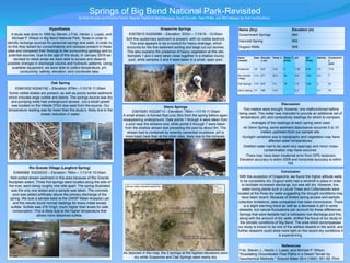
Springs of Big Bend National Park-Revisited
By Nick Armetta and Kristina Femal. Special Thanks to Neil Heywood, David Ozsvath, Tyler Phillip, and Ally Liebman for their contributions..
Name
(Tested)
Date Elevatio
n (m)
Temp ℃ Temp ℃
(Fritz)
pH pH
(Fritz)
Salinity Conductivit
y
(mV)
Grapevine 1/9 933 13.8 9 7.32 8.04 0.2 17.8
Rio Grande
Village
1/13 571 40.3 35 6.8 7.26 0.5 7
Oak Springs 1/10 879 7.9 19 7.9 7.48 0 53
Glenn Spring 1/7 780 13.6 - 8.3 - 0.1 76
Name (Dry) Elevation (m)
Government Springs 960
Hannold Spring 952
Dugout Wells 908
Conclusion
With the exception of Grapevine, we found the higher altitude wells
to be completely dry. Dugout wells had a windmill in place in order
to facilitate increased discharge, but was still dry. However, live,
water-loving plants such a Locust Trees and Cottonwoods were
located at the three dry wells suggesting the drought conditions may
have been recent. Because of limited spring access and sample
collection limitations, data comparison has been inconclusive. There
is a slight warming trend as well as a decrease in pH in some
datasets, but natural fluctuations can account for these differences.
Springs that were testable had a noticeably low discharge and this,
along with the amount of dry wells, shifted the focus of our study to
the climatic conditions of Big Bend. The area which encompasses
our study is known to be one of the wettest deserts in the world, and
further research could shed more light on the recent dry conditions it
is experiencing.
As depicted in this map, the 2 springs at the highest elevations were
dry while Grapevine and Oak Springs were nearly dry.
References
Fritz, Steven J., Hector J. Lopez, and Michael P. Wilson.
"Elusidating Groundwater Flow Paths in a Desert Terrain by
Geochemical Methods." Ground Water 28.4 (1990): 551-58. Print.