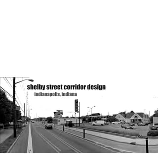
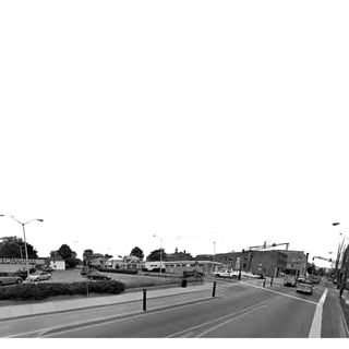
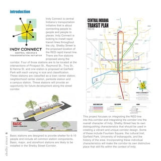
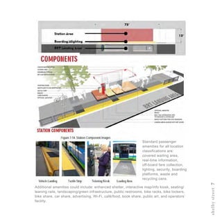
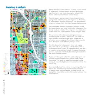
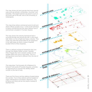
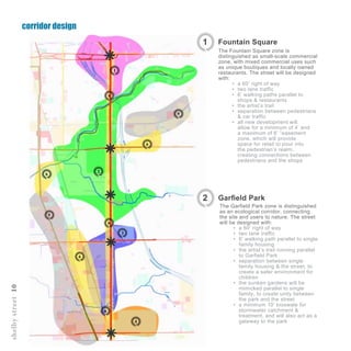
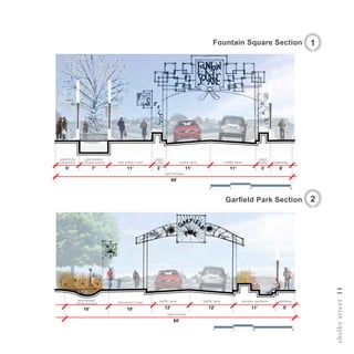
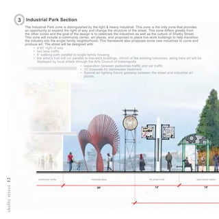
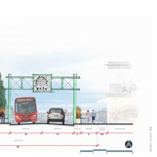
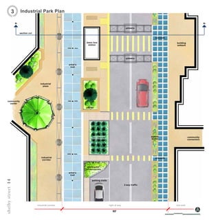
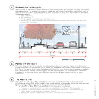
rebecca m. ludwig
landscape architecture 2015
ball state university
R
L
RL
introduction2
Hello! My name is Rebecca and I want to thank you for
taking the time to go through this portfolio.
I am from a small rural area in southern Indiana called
Ogilville, but had other stomping grounds in Columbus, IN.
There, I grew up on my dad’s farm with two older brothers.
This is where my passions for the environment began. Some
of my fondest memories were playing in the woods with my
brothers and catching “crawdads” in the creek.
Columbus is just a twenty minute drive away and is where
I went to school. Living in an architecturally rich city
influenced and inspired me to pursue a career in landscape
architecture. I knew for a long time I wanted to go to Ball
State University to study in their architecture program.
I put passion and hard work into everything I do and
my interests are deeply rooted in landscape design and
environmental stewardship. I hope you enjoy my portfolio
work!
introduction3
indianapolis, indiana
shelby street corridor design
introduction
shelbystreet6
Indy Connect is central
Indiana’s transportation
initiative that is about
connecting people to
people and people to
places. Indy Connect is
looking to install rapid
transit lines throughout
the city. Shelby Street is
the proposed location of
the RED rapid transit line.
There are five stations
proposed along the
corridor. Four of those stations are to be located at the
intersections of Prospect St., Raymond St., Troy St.,
& Hanna St. and one station is proposed at Garfield
Park with each varying in size and classification.
These stations are classified as a town center station,
neighborhood center station, parkside station and
a campus station. These stations will provide an
opportunity for future development along the street
corridor.
BLUE LINE
RED LINE
PURPLE LINE
ORANGE LINE
GREEN LINE
EXPRESS BUS
HIGH-FREQUENCY BUS
ENHANCED LOCAL BUS
CIRCULATORS
INTERSTATE
COUNTY LINE
TRANSIT CENTER
TRANSFER STATIONS
STATION STOPS
NOTE:STATIONSTOPSSHOWNFOR
ILLUSTRATIONONLY,LOCATIONSTBD
CENTRALINDIANA
TRANSIT PLANPHASEONE
THIS IS A PLANNING LEVEL MAP
alignments of transit lines as well as
the number and location of stations will be
determined in detailed corridor studies with
nvolvement.
HENDRICKSCOUNTY
MARIONCOUNTY
BOONECOUNTY
HAMILTONCOUNTY
65
465
74
69
70
465
465
465
70
65
86TH
ST
116TH
ST
71ST
ST
56TH
ST
38TH
ST
16TH
ST
MICHIGANST
10TH
ST
WASHINGTONST
MICHIGANRD
KEYSTONEAVE
COLLEGEAVE
MERIDIANST
BINFORDBLVD
146TH
ST
131ST
ST
106TH
ST
MAINST
MAINST
BOONECOUNTY
MARIONCOUNTY
HAMILTONCOUNTY
MARIONCOUNTY
MARIONCOUNTY
HANCOCKCOUNTY
JOHNSONCOUNTY
MARIONCOUNTY
MORGANCOUNTY
MARIONCOUNTY
NOBLESVILLE
LAWRENCE
CUMBERLAND
GREENWOOD
SOUTHPORT
IMS
AIRPORT
DOWNTOWN
IRVINGTON
IUPUI
BUTLER
UNIVERSITY
LAFAYETTE
SQUARE
BROAD
RIPPLE
KEYSTONE
ATTHECROSSING
PARK100
EAGLE
CREEK
GEIST
AMERIPLEX
ZOO
IMA
STATE
FAIR
WASHINGTON
SQUAREMALL
FORTHARRISON
STATEPARK
CASTLETON
SQUAREMALL
PALLADIUM
CLAY
TERRACE
WEST
CLAY
THE
PYRAMIDS
TRADERS
POINT
GREENWOOD
PARKMALL
UINDY
GLENDALE
MALL
WESTFIELD
MARTIN
UNIVERSITY
MARIAN
UNIVERSITY
CARMEL
BEECH
GROVE
SPEEDWAY
BENDAVIS
FISHERS
HAMILTON
TOWNCENTER
BROWNSBURG
AVON
PLAINFIELD
IUHEALTH
NORTHHOSPITAL
COMMUNITY
NORTHHOSPITALST.VINCENT
HOSPITAL
COMMUNITY
EASTHOSPITAL
ST.FRANCIS
HOSPITAL
COMMUNITY
SOUTHHOSPITAL
ZIONSVILLE
FOUNTAIN
SQUARE
ST.VINCENT
CARMELHOSPITAL
CONNER
PRAIRIE
This project focuses on integrating the RED line
into this corridor and integrating the corridor into the
overall character of Indy. Shelby Street has its own
distinguishing characteristics that should be used in
creating a vibrant and unique corridor design. Some
of these include Fountain Square, the cultural trail,
Garfield Park, University of Indianapolis, and the
history of the area. Incorporating these individual
characteristics will make the corridor its own distinctive
place that still fits within the context of Indy.
Basic stations are designed to provide shelter for 6-10
people and include all common station components.
Basic, major, and storefront stations are likely to be
installed in the Shelby Street Corridor.
shelbystreet7
Standard passenger
amenities for all location
classifications are:
covered waiting area,
real-time information,
off-board fare collection,
lighting, security, boarding
platforms, waste and
recycling cans.
Additional amenities could include: enhanced shelter, interactive map/info kiosk, seating/
leaning rails, landscaping/green infrastructure, public restrooms, bike racks, bike lockers,
bike share, car share, advertising, Wi-Fi, café/food, book share, public art, and operators’
facility.
shelbystreet8
Shelby Street is located within the Fountain Square District
of Indianapolis. Fountain Square is unique & culturally
significant to the site. Understanding the culture of this
district will be important for the corridor design.
Fountain square is an active and lively place with many
young artists and entrepreneurs living close by. According
to the locals it is “anything but square”. The design should
reflect the culture of this district and engage the community.
The corridor has a distinct beginning at Fountain square,
and a less distinct end at the University of Indianapolis. The
design needs to make the University more of a destination
on the street than just an element located along the street.
The street has different zones including commercial,
residential, park or “green”, and industry. The street has
many different industries located along the way and is
where the commercially significant historic district can be
seen. These will create different prototype zones.
The Arts Council of Indianapolis’s vision is to engage
the public with art by nurturing a culture where artists &
organizations thrive. This is an integrated part of Indy and it
is important to consider and include throughout the design
process, especially with Shelby Street being located within
the artistic Fountain Square.
Public Art Indianapolis is the city’s public art program and
provides opportunities for Indy’s diverse arts & cultural
community. This would be great to incorporate into the
design, to make Shelby Street an integrated corridor to the
rest of Indy.
Indianapolis Cultural Trail ends at the beginning of fountain
square and provides a huge opportunity for connection
to Shelby Street. It would be ideal to create another trail
through the site and that would celebrate the culture of this
distinct district.
inventory & analysis
shelbystreet9
streets & stations
greenways & bike
trails
ecological corridors
industrial
commercial
special uses
There are five future red-line stations located along
the corridor. Four of the stations will be located at
major intersections of Prospect, Raymond, Troy,
& Hanna and there will be one station located at
Garfield Park.
The Interurban Trail (located off of Madison) &
Cultural Trail (ends at Fountain Square) provides
an oppurtuunity to connect the Shelby Street
corridor to the rest of Indy.
There is defined ecological framework that runs
through the Shelby Street corridor. Garfield
Park, Pogues Run and a stream system are all
located within this zone of the street. This is a
distinguished zone that is different from the rest of
the street.
The map shows the industry framework that is
occuring through and around the site. In the south
half, there is a mix of light and heavy industry. This
is the only area that would allow for an expansion
in the right away as there is seas of asphalt
located infront of the industries.
This map show where commercial (pink & red) and
where offices (purple) occur. In the south half there
is heavy commercial and the other heavier hub of
commerical is located in Fountain Square.
The map shows are land parcels that have special
uses such as schools, universities, churches, and
hospitals. The largest special use parcel occurs in
the south half of the site, and is the University of
Indianapolis.
corridor design
shelbystreet10
1
2
3
4
5
6
6
6
5
6
6
6
Scale - !” = 500’
The Garfield Park zone is distinguished
as an ecological corridor, connecting
the site and users to nature. The street
will be designed with:
•	 a 60’ right of way
•	 two lane traffic
•	 6’ walking path parallel to single
family housing
•	 the artist’s trail running parallel
to Garfield Park
•	 separation between single
family housing & the street, to
create a safer environment for
children
•	 the sunken gardens will be
mimicked parallel to single
family, to create unity between
the park and the street
•	 a minimum 10’ bioswale for
stormwater catchment &
treatment, and will also act as a
gateway to the park
Fountain Square1
The Fountain Square zone is
distinguished as small-scale commercial
zone, with mixed commercial uses such
as unique boutiques and locally owned
restaurants. The street will be designed
with:
•	 a 60’ right of way
•	 two lane traffic
•	 6’ walking paths parallel to
shops & restaurants
•	 the artist’s trail
•	 separation between pedestrians
& car traffic
•	 all new development will
allow for a minimum of 4’ and
a maximum of 6’ “easement
zone, which will provide
space for retail to pour into
the pedestrian’s realm,
creating connections between
pedestrians and the shops
Garfield Park2
shelbystreet11
Garfield Park Section
traffic lane pathway
5’
the artist’s trail
12’
stormwater
infrastructure
10’10’
right-of-way
60’
traffic lane
12’ 11’
sunken gardens
2
Fountain Square Section 1
stormwater
infrastructure
7’
storefront
easement
5’
right-of-way
60’
the artist’s trail
11’
plant
buffer traffic lane
11’3’
traffic lane
11’
plant
buffer
3’ 6’
pathway
shelbystreet12
industrial plazacommunity center the artist’s trail rapid transit station
15’20’ 12’
The Industrial Park zone is distinguished by the light & heavy industrial. This zone is the only zone that provides
an opportunity to expand the right of way and change the structure of the street. This zone differs greatly from
the other zones and the goal of the design is to celebrate the industries as well as the culture of Shelby Street.
This zone will include a community center, art plazas, and proposed to place live-work buildings to help transition
the industry into the single family neighborhood. This framework also proposes some new industries to come and
produce art. The street will be designed with:
•	 a 60’ right of way
•	 two lane traffic
•	 6’ walking path parallel to single family housing
•	 the artist’s trail will run parallel to live-work buildings, infront of the existing industries. along here art will be
displayed by local artists through the Arts Council of Indianapolis
3 Industrial Park Section
•	 separation between pedestrian traffic and car traffic
•	 10’ bioswale for stormwater treatment
•	 Special art lighting fixture gateway between the street and industrial art
plazas.
shelbystreet13
traffic lane traffic lane pathway business
setback
live-work unitsplanting
12’ 12’ 6’ 4-6’3’
right of way
60’
right of wayindustrial corridor
60’
live work
parking stalls
stormwater
infrastructure
stormwater
infrastructure
basic bus
station
gateway
gateway
community
center
industrial
plaza
artist’s
trail
building
setback
sidewalk
planter
planter
buffer
community
connectors
industrial
corridor
artist’s
trail
sidewalk
2-way traffic
section cut
a1 a2
shelbystreet14
Industrial Park Plan3
shelbystreet15
University of Indianapolis
The University of Indianapolis zone is defined by the university and is assuming the university will expand
past Madison Ave. The goal for this zone is to create flow and connectivity between the different sides of
campus. This will be done by creating a study plaza for student to enjoy along the artist’s trail. The street
will be designed with:
•	 a 60’ right of way
•	 two lane traffic
•	 6’ walking path parallel to single family housing
•	 the artist’s trail will run parallel to the study plaza and will connect the university with the other
zones in the framework
4
Points of Connection
This zone does not have to do with the street design itself, but is an important aspect to the framework.
Connectivity in the city is important, and on goal of this framework is to connect Shelby Street to the rest of
Indy. To do this, points of connection have been identified. One point of connection is located on Madison
Ave., where there is a heavy commercial zone and the interurban trail. The second point of connection
is located off of Raymond Street, over I-65 where there is light & heavy industry, as well as some
commercial.
5
The Artist’s Trail
The Artist’s trail is the glue of the whole framework. It is a constant element in each zone to create
connectivity & fluidity in the design. In each zone, characteristics of the trail will remain the same, such as
lighting, signage and paving patterns. Design characteristics of the Artist’s trail:
•	 Minimum 10’ wide, with 5’ for pedestrians, and the other 5’ for bicyclists
•	 Features art from local artists and to be connected to the Arts Council of Indianapolis
•	 Connects to the Cultural Trail at Fountain Square and the Interurban Trail on Madison Ave.
•	 Trail is well lit to provide a safe pedestrian corridor
•	 Signage will indicate zone locations, as well as special events or information
6
traffic lane pathway
12’ 6’
traffic lane
12’6’
pathwaystudy plazathe artist’s trail
14’10’
right-of-way
60’
samplework16
Craddock Wetland: planting design
SAL-A) 565
SIL-P) 565
SOR-N) 847
VER-V) 565
PAN-V) 674
RAT-P) 1011
VER-F) 337
ECH-PAL) 824
ERY-Y) 549
LIA-S) 824
SCH-S) 1099
ASC-T) 361
BAP-AUS) 541
SCH-S) 451
LIA-S) 181
RUD-H) 544
SCH-S) 363
ECH-PUR) 332
LIA-S) 222
SPO-H) 277
ECH-PAL) 292
ERY-Y) 195
LIA-S) 292
SCH-S) 390
PAN-V) 1572
RAT-P) 786
VER-F) 2357
SAL-A) 971
SIL-L) 971
SOR-N) 1457
VER-V) 971
ASC-S) 336
BAP-ALB) 504
SCH-S) 420
DAL-P) 524
RUD-H) 786
SCH-S) 655
ALL-S) 304
DAL-P) 524
SPO-H) 254
ECH-PUR) 486
LIA-S) 222
SPO-H) 277
PRODUCEDBYANAUTODESKEDUCATIONALPRODUCT
PRODUCED BY AN AUTODESK EDUCATIONAL PRODUCT
Wheaton Park District Sign: Danada - Play for All Playground
TREE HOUSE AREA
HORSE FARM PLAYGROUND
WATER PLAY AREA
TREE TOP SWINGS
ADVENTURESCAPE / BOULDER CLIMB AREA
PONY STABLES PLAYGROUND
CENTRAL GATHERING AREA
SOUND GARDEN
FRAGRANCE GARDEN
PHASE 1
PHASE 4
PHASE 4
PHASE 2
PHASE 2
PHASE 3
PHASE 1
PHASE 1
PHASE 1
samplework17
Construction documents: Rendered Plan Detail
samplework18
Construction documents: Rendered Bioretention Detail
samplework19
wetland park photomontage
samplework20
samplework21

Portfolio_Project

  • 1.
    rebecca m. ludwig landscapearchitecture 2015 ball state university R L
  • 3.
    RL introduction2 Hello! My nameis Rebecca and I want to thank you for taking the time to go through this portfolio. I am from a small rural area in southern Indiana called Ogilville, but had other stomping grounds in Columbus, IN. There, I grew up on my dad’s farm with two older brothers. This is where my passions for the environment began. Some of my fondest memories were playing in the woods with my brothers and catching “crawdads” in the creek. Columbus is just a twenty minute drive away and is where I went to school. Living in an architecturally rich city influenced and inspired me to pursue a career in landscape architecture. I knew for a long time I wanted to go to Ball State University to study in their architecture program. I put passion and hard work into everything I do and my interests are deeply rooted in landscape design and environmental stewardship. I hope you enjoy my portfolio work!
  • 4.
  • 5.
  • 7.
    introduction shelbystreet6 Indy Connect iscentral Indiana’s transportation initiative that is about connecting people to people and people to places. Indy Connect is looking to install rapid transit lines throughout the city. Shelby Street is the proposed location of the RED rapid transit line. There are five stations proposed along the corridor. Four of those stations are to be located at the intersections of Prospect St., Raymond St., Troy St., & Hanna St. and one station is proposed at Garfield Park with each varying in size and classification. These stations are classified as a town center station, neighborhood center station, parkside station and a campus station. These stations will provide an opportunity for future development along the street corridor. BLUE LINE RED LINE PURPLE LINE ORANGE LINE GREEN LINE EXPRESS BUS HIGH-FREQUENCY BUS ENHANCED LOCAL BUS CIRCULATORS INTERSTATE COUNTY LINE TRANSIT CENTER TRANSFER STATIONS STATION STOPS NOTE:STATIONSTOPSSHOWNFOR ILLUSTRATIONONLY,LOCATIONSTBD CENTRALINDIANA TRANSIT PLANPHASEONE THIS IS A PLANNING LEVEL MAP alignments of transit lines as well as the number and location of stations will be determined in detailed corridor studies with nvolvement. HENDRICKSCOUNTY MARIONCOUNTY BOONECOUNTY HAMILTONCOUNTY 65 465 74 69 70 465 465 465 70 65 86TH ST 116TH ST 71ST ST 56TH ST 38TH ST 16TH ST MICHIGANST 10TH ST WASHINGTONST MICHIGANRD KEYSTONEAVE COLLEGEAVE MERIDIANST BINFORDBLVD 146TH ST 131ST ST 106TH ST MAINST MAINST BOONECOUNTY MARIONCOUNTY HAMILTONCOUNTY MARIONCOUNTY MARIONCOUNTY HANCOCKCOUNTY JOHNSONCOUNTY MARIONCOUNTY MORGANCOUNTY MARIONCOUNTY NOBLESVILLE LAWRENCE CUMBERLAND GREENWOOD SOUTHPORT IMS AIRPORT DOWNTOWN IRVINGTON IUPUI BUTLER UNIVERSITY LAFAYETTE SQUARE BROAD RIPPLE KEYSTONE ATTHECROSSING PARK100 EAGLE CREEK GEIST AMERIPLEX ZOO IMA STATE FAIR WASHINGTON SQUAREMALL FORTHARRISON STATEPARK CASTLETON SQUAREMALL PALLADIUM CLAY TERRACE WEST CLAY THE PYRAMIDS TRADERS POINT GREENWOOD PARKMALL UINDY GLENDALE MALL WESTFIELD MARTIN UNIVERSITY MARIAN UNIVERSITY CARMEL BEECH GROVE SPEEDWAY BENDAVIS FISHERS HAMILTON TOWNCENTER BROWNSBURG AVON PLAINFIELD IUHEALTH NORTHHOSPITAL COMMUNITY NORTHHOSPITALST.VINCENT HOSPITAL COMMUNITY EASTHOSPITAL ST.FRANCIS HOSPITAL COMMUNITY SOUTHHOSPITAL ZIONSVILLE FOUNTAIN SQUARE ST.VINCENT CARMELHOSPITAL CONNER PRAIRIE This project focuses on integrating the RED line into this corridor and integrating the corridor into the overall character of Indy. Shelby Street has its own distinguishing characteristics that should be used in creating a vibrant and unique corridor design. Some of these include Fountain Square, the cultural trail, Garfield Park, University of Indianapolis, and the history of the area. Incorporating these individual characteristics will make the corridor its own distinctive place that still fits within the context of Indy. Basic stations are designed to provide shelter for 6-10 people and include all common station components. Basic, major, and storefront stations are likely to be installed in the Shelby Street Corridor.
  • 8.
    shelbystreet7 Standard passenger amenities forall location classifications are: covered waiting area, real-time information, off-board fare collection, lighting, security, boarding platforms, waste and recycling cans. Additional amenities could include: enhanced shelter, interactive map/info kiosk, seating/ leaning rails, landscaping/green infrastructure, public restrooms, bike racks, bike lockers, bike share, car share, advertising, Wi-Fi, café/food, book share, public art, and operators’ facility.
  • 9.
    shelbystreet8 Shelby Street islocated within the Fountain Square District of Indianapolis. Fountain Square is unique & culturally significant to the site. Understanding the culture of this district will be important for the corridor design. Fountain square is an active and lively place with many young artists and entrepreneurs living close by. According to the locals it is “anything but square”. The design should reflect the culture of this district and engage the community. The corridor has a distinct beginning at Fountain square, and a less distinct end at the University of Indianapolis. The design needs to make the University more of a destination on the street than just an element located along the street. The street has different zones including commercial, residential, park or “green”, and industry. The street has many different industries located along the way and is where the commercially significant historic district can be seen. These will create different prototype zones. The Arts Council of Indianapolis’s vision is to engage the public with art by nurturing a culture where artists & organizations thrive. This is an integrated part of Indy and it is important to consider and include throughout the design process, especially with Shelby Street being located within the artistic Fountain Square. Public Art Indianapolis is the city’s public art program and provides opportunities for Indy’s diverse arts & cultural community. This would be great to incorporate into the design, to make Shelby Street an integrated corridor to the rest of Indy. Indianapolis Cultural Trail ends at the beginning of fountain square and provides a huge opportunity for connection to Shelby Street. It would be ideal to create another trail through the site and that would celebrate the culture of this distinct district. inventory & analysis
  • 10.
    shelbystreet9 streets & stations greenways& bike trails ecological corridors industrial commercial special uses There are five future red-line stations located along the corridor. Four of the stations will be located at major intersections of Prospect, Raymond, Troy, & Hanna and there will be one station located at Garfield Park. The Interurban Trail (located off of Madison) & Cultural Trail (ends at Fountain Square) provides an oppurtuunity to connect the Shelby Street corridor to the rest of Indy. There is defined ecological framework that runs through the Shelby Street corridor. Garfield Park, Pogues Run and a stream system are all located within this zone of the street. This is a distinguished zone that is different from the rest of the street. The map shows the industry framework that is occuring through and around the site. In the south half, there is a mix of light and heavy industry. This is the only area that would allow for an expansion in the right away as there is seas of asphalt located infront of the industries. This map show where commercial (pink & red) and where offices (purple) occur. In the south half there is heavy commercial and the other heavier hub of commerical is located in Fountain Square. The map shows are land parcels that have special uses such as schools, universities, churches, and hospitals. The largest special use parcel occurs in the south half of the site, and is the University of Indianapolis.
  • 11.
    corridor design shelbystreet10 1 2 3 4 5 6 6 6 5 6 6 6 Scale -!” = 500’ The Garfield Park zone is distinguished as an ecological corridor, connecting the site and users to nature. The street will be designed with: • a 60’ right of way • two lane traffic • 6’ walking path parallel to single family housing • the artist’s trail running parallel to Garfield Park • separation between single family housing & the street, to create a safer environment for children • the sunken gardens will be mimicked parallel to single family, to create unity between the park and the street • a minimum 10’ bioswale for stormwater catchment & treatment, and will also act as a gateway to the park Fountain Square1 The Fountain Square zone is distinguished as small-scale commercial zone, with mixed commercial uses such as unique boutiques and locally owned restaurants. The street will be designed with: • a 60’ right of way • two lane traffic • 6’ walking paths parallel to shops & restaurants • the artist’s trail • separation between pedestrians & car traffic • all new development will allow for a minimum of 4’ and a maximum of 6’ “easement zone, which will provide space for retail to pour into the pedestrian’s realm, creating connections between pedestrians and the shops Garfield Park2
  • 12.
    shelbystreet11 Garfield Park Section trafficlane pathway 5’ the artist’s trail 12’ stormwater infrastructure 10’10’ right-of-way 60’ traffic lane 12’ 11’ sunken gardens 2 Fountain Square Section 1 stormwater infrastructure 7’ storefront easement 5’ right-of-way 60’ the artist’s trail 11’ plant buffer traffic lane 11’3’ traffic lane 11’ plant buffer 3’ 6’ pathway
  • 13.
    shelbystreet12 industrial plazacommunity centerthe artist’s trail rapid transit station 15’20’ 12’ The Industrial Park zone is distinguished by the light & heavy industrial. This zone is the only zone that provides an opportunity to expand the right of way and change the structure of the street. This zone differs greatly from the other zones and the goal of the design is to celebrate the industries as well as the culture of Shelby Street. This zone will include a community center, art plazas, and proposed to place live-work buildings to help transition the industry into the single family neighborhood. This framework also proposes some new industries to come and produce art. The street will be designed with: • a 60’ right of way • two lane traffic • 6’ walking path parallel to single family housing • the artist’s trail will run parallel to live-work buildings, infront of the existing industries. along here art will be displayed by local artists through the Arts Council of Indianapolis 3 Industrial Park Section • separation between pedestrian traffic and car traffic • 10’ bioswale for stormwater treatment • Special art lighting fixture gateway between the street and industrial art plazas.
  • 14.
    shelbystreet13 traffic lane trafficlane pathway business setback live-work unitsplanting 12’ 12’ 6’ 4-6’3’ right of way 60’
  • 15.
    right of wayindustrialcorridor 60’ live work parking stalls stormwater infrastructure stormwater infrastructure basic bus station gateway gateway community center industrial plaza artist’s trail building setback sidewalk planter planter buffer community connectors industrial corridor artist’s trail sidewalk 2-way traffic section cut a1 a2 shelbystreet14 Industrial Park Plan3
  • 16.
    shelbystreet15 University of Indianapolis TheUniversity of Indianapolis zone is defined by the university and is assuming the university will expand past Madison Ave. The goal for this zone is to create flow and connectivity between the different sides of campus. This will be done by creating a study plaza for student to enjoy along the artist’s trail. The street will be designed with: • a 60’ right of way • two lane traffic • 6’ walking path parallel to single family housing • the artist’s trail will run parallel to the study plaza and will connect the university with the other zones in the framework 4 Points of Connection This zone does not have to do with the street design itself, but is an important aspect to the framework. Connectivity in the city is important, and on goal of this framework is to connect Shelby Street to the rest of Indy. To do this, points of connection have been identified. One point of connection is located on Madison Ave., where there is a heavy commercial zone and the interurban trail. The second point of connection is located off of Raymond Street, over I-65 where there is light & heavy industry, as well as some commercial. 5 The Artist’s Trail The Artist’s trail is the glue of the whole framework. It is a constant element in each zone to create connectivity & fluidity in the design. In each zone, characteristics of the trail will remain the same, such as lighting, signage and paving patterns. Design characteristics of the Artist’s trail: • Minimum 10’ wide, with 5’ for pedestrians, and the other 5’ for bicyclists • Features art from local artists and to be connected to the Arts Council of Indianapolis • Connects to the Cultural Trail at Fountain Square and the Interurban Trail on Madison Ave. • Trail is well lit to provide a safe pedestrian corridor • Signage will indicate zone locations, as well as special events or information 6 traffic lane pathway 12’ 6’ traffic lane 12’6’ pathwaystudy plazathe artist’s trail 14’10’ right-of-way 60’
  • 17.
    samplework16 Craddock Wetland: plantingdesign SAL-A) 565 SIL-P) 565 SOR-N) 847 VER-V) 565 PAN-V) 674 RAT-P) 1011 VER-F) 337 ECH-PAL) 824 ERY-Y) 549 LIA-S) 824 SCH-S) 1099 ASC-T) 361 BAP-AUS) 541 SCH-S) 451 LIA-S) 181 RUD-H) 544 SCH-S) 363 ECH-PUR) 332 LIA-S) 222 SPO-H) 277 ECH-PAL) 292 ERY-Y) 195 LIA-S) 292 SCH-S) 390 PAN-V) 1572 RAT-P) 786 VER-F) 2357 SAL-A) 971 SIL-L) 971 SOR-N) 1457 VER-V) 971 ASC-S) 336 BAP-ALB) 504 SCH-S) 420 DAL-P) 524 RUD-H) 786 SCH-S) 655 ALL-S) 304 DAL-P) 524 SPO-H) 254 ECH-PUR) 486 LIA-S) 222 SPO-H) 277 PRODUCEDBYANAUTODESKEDUCATIONALPRODUCT PRODUCEDBYANAUTODESKEDUCATIONALPRODUCT PRODUCEDBYANAUTODESKEDUCATIONALPRODUCT PRODUCED BY AN AUTODESK EDUCATIONAL PRODUCT
  • 18.
    Wheaton Park DistrictSign: Danada - Play for All Playground TREE HOUSE AREA HORSE FARM PLAYGROUND WATER PLAY AREA TREE TOP SWINGS ADVENTURESCAPE / BOULDER CLIMB AREA PONY STABLES PLAYGROUND CENTRAL GATHERING AREA SOUND GARDEN FRAGRANCE GARDEN PHASE 1 PHASE 4 PHASE 4 PHASE 2 PHASE 2 PHASE 3 PHASE 1 PHASE 1 PHASE 1 samplework17
  • 19.
    Construction documents: RenderedPlan Detail samplework18
  • 20.
    Construction documents: RenderedBioretention Detail samplework19
  • 21.
  • 22.