The document discusses two hiking trails in the Columbia River Gorge - Hamilton Mountain trail and the construction of new off-road vehicle trails in Yacolt Burn State Forest. Hamilton Mountain trail is a popular 3.2 mile hike with stunning views of the Columbia River and surrounding areas. It caters to hikers of all abilities but does require a 2000 foot elevation gain. Meanwhile, construction has started on 35 miles of new ATV trails, 10 miles of dirt bike trails, and 30 miles of 4x4 trails in Yacolt Burn State Forest after 7 years of planning and permitting. Local off-road vehicle clubs are volunteering to build the trails and sections will open to the public as they are completed.
Gray Creek to Kimberley Trans Canada Trail PhotoAlbum PresentationTrails BC
This 2005 and revised in 2008 Trails BC photo album/PowerPoint Presentation looks at the potential of a Trans Canada Trail routing option between Gray Creek and Kimberley BC
Clairemont CPG Ad Hoc Subcommittee MeetingCirculateSD
On Tuesday, May 10, 2016, the project team presented on the study area's existing condition to the Clairemont Community Planning Group Ad Hoc Subcommittee.
The Cranbrook Access Options to new Rails TrailsTrails BC
This photo album report high lights the access options that are required to intergrate the new Cranbrook to Kimberley Rails to the existing trail infrastructure in Cranbrook. This would allow community recreationalists a safe and green access from the popular Rotary Way to the new pathway.
Nelway BC to Yahk Trans Canada Trail Route Assessment ReportTrails BC
This is a 2004 report on the feasibility of a Trans Canada Trail route between Nelway and Yahk BC. Other routing options were eventually decided on, however this route option has the potentail to be a connecting spur trail to the TCT at Salmo
Cranbrook to Baynes Lake, BC TCT Route ProposalTrails BC
This 2005 PPT/Photo Album outlines the rational that Trails BC used in rerouting the proposed TCT route between Cranbrook and Baynes Lake from the east side of the Kootenay River to the West Side.
Stony Creek in context of Waterways of the WestTony Smith
Update on presentation given twice in recent months with ever increasing photo coverage of the length of Stony Creek and historic diversions, wrapped in contextual commentary re pollution event from industrial fire and establishment of Waterways of the West Ministerial Advisory Committee.
The Transportation Alternatives Brooklyn Committee urges NYC DOT to re-examine conditions near the Jay Street Plaza. Access to entry points are dangerous and construction planned in 2010 will only worsen the situations. This presentation scratches the surface of this problem.
The top trails in Yarra Valley include leisurely walks and energetic hikes, magnificent national parks and also walks around town. Some of the best trails are Steavenson Falls Trail, Cumberland Walk, Lake Mountain Summit Walk, etc. The weather in Melbourne is generally hot from December to February and cools down from March to May. The most preferred accommodation options are Oaks on Collins, Oaks on Lonsdale, etc.
Étude exclusive
Web, mobilité, réseaux sociaux: promouvoir son évènement et valoriser ses commanditaires
Guillaume Brunet
Associé
Substance Stratégies
Voir biographie
Substance stratégies, firme spécialisée en stratégies numériques et marketing, s’est penchée sur l’utilisation des différentes plateformes numériques exploitées par les événements majeurs internationaux du Québec pour faire mousser leur popularité et entretenir la conversation avec leurs fans.
Les résultats de son étude exclusive permettent aujourd’hui de répondre à plusieurs questions capitales pour tout évènement et pour les marques désirant s’y associer :
Comment valoriser les commanditaires par la mobilité?
Comment inclure de façon optimale les réseaux sociaux à sa stratégie?
Quels sont les principaux défis à relever et éléments à améliorer pour offrir aux participants et aux commanditaires une expérience maximale?
Guillaume Brunet, spécialiste en marketing numérique, partagera les résultats de cette enquête qui met en relief les forces de l’industrie de l’événement en matière d’emploi des plateformes numériques. Elle vous fournira toutes les données les plus récentes vous permettant d’implanter une approche web performante dans le cadre de la promotion d’un événement.
Title: Complete Freeways: Evaluation of Florida's Bicycles on Limited Access Facilities Pilot Program
Track: Connect
Format: 60 minute panel
Abstract: The Florida "Bicycles on Limited Access Facilities Pilot Program" has improved three limited access bridges to allow use by bicyclists. Bridge modifications include conventional and innovative improvements. Before and after data suggest that these pilot projects have been beneficial and a full evaluation will be conducted to see if the program could be expanded to other limited access facilities in Florida.
Presenters:
Presenter: David Henderson Miami-Dade MPO
Co-Presenter: Stewart Robertson Kimley-Horn and Associates, Inc.
East Coast Greenway Alliance is sponsoring 4 bike rides this year, including one new one to City Island! All are welcome to join the ECGA and ride for free thereafter for the full year!
Long-distance Hiking Trails in the USA; With so many awe-inspiring trails, the issue lies in where to go next. For expert advice, Active Times consulted two experienced hikers, Philip Werner and Rick McCharles.
Very Cool Michigan High Adventures 05 (Scouts)Steve Lagreca
Exciting, adventurous campouts for Michigan Scouts, Venturers, and those who enjoy the outdoors.
- Michigan's Tri-county area
- Within a (long) day’s drive
Includes descriptions, photos, areas of interest, and patches.
1. • Classified Ads
SECTION B
May 28, 2014 www.TheReflector.com
Popular Gorge trail lures variety
of hikers of all ages
Steve Kadel
staff reporter
Walk a shaded trail just 1.25 miles to an attrac-
tive, cooling waterfall with close-up views from
a rustic wooden bridge. Or keep going another
2 miles, with some significant elevation gain, to
emerge in an alpine wonderland with 180 degree
views of the Columbia River and a riot of flowers
that demand to be photographed.
Hamilton Mountain on the Washington side of
the Gorge has something for everyone, from fam-
ilies with young children to mountaineers train-
ing to climb one of the Cascade volcanoes. It’s
3.2 miles and 2,000 feet of uphill to the top, but
no matter how much of Hamilton you bite off it’s
bound to be a rewarding experience.
Wildflowers were near their peak on May 17,
but the show should still be dazzling for the next
couple of weeks.
Hamilton is the obvious “stairstep” mountain
just north of Beacon Rock. It’s not necessary to
go to the top step for views that will stop you in
your tracks. A side trail about two-thirds up the
mountain leads to a grassy knoll perfect for a pic-
nic or simply stretching out in the sun.
Those who go all the way will enjoy an airy se-
ries of exposed switchbacks on a trail lined with
rocks before re-entering woods for the final run
to the summit. The rocks can be unstable and
many hikers like to use trekking poles here for
added stability.
As with other popular Gorge hikes, don’t expect
solitude here. There will be a steady procession of
hikers going up and down, but almost all are pleas-
ant and will ask how you’re doing or let you pet
their dog. Most folks who bring canines courteous-
ly keep them leashed, which is the requirement.
The actual summit is brushy but still offers a
glorious glimpse of Mount Hood and Mount Ad-
ams along with Table Mountain to the east. Some
hikers prefer to take a slightly longer loop trail on
the way down for less impact to their knees than
the steeper standard trail.
To reach the trailhead, drive east on Highway
14 through Camas and Stevenson and turn left
toward the parking lot upon reaching Beacon
Rock State Park. A State of Washington Discov-
ery Pass is required to park at the trailhead, and
if you don’t have one a day pass is sold in a near-
by state park office for $10 along with the annu-
al pass for $30.
Plan to arrive early on a sunny weekend if you
want to find space in the lower parking lot. An
overflow lot is located a little higher on the en-
trance road and will add about 10 minutes to
your hiking time each way. There are flush toi-
lets in a stone restroom at the trailhead.
Construction starts after 7 years
of planning, permit acquisition
Steve Kadel
staff reporter
Those who enjoy off-road vehicles will
have several miles of new trails to explore
before long.
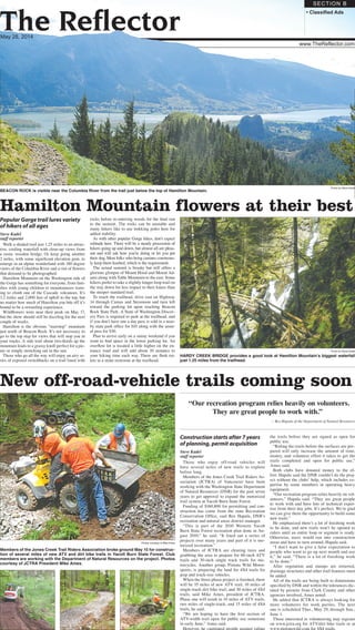
Members of the Jones Creek Trail Riders As-
sociation (JCTRA) of Vancouver have been
working with the Washington State Department
of Natural Resources (DNR) for the past seven
years to get approval to expand the motorized
trail system at Yacolt Burn State Forest.
Funding of $160,800 for permitting and con-
struction has come from the state Recreation
Conservation Office, said Rex Hapala, DNR’s
recreation and natural areas district manager.
“This is part of the 2010 Western Yacolt
Burn State Forest recreation plan done in Au-
gust 2010,” he said. “It lined out a series of
projects over many years and part of it is mo-
torized recreation.”
Members of JCTRA are clearing trees and
grubbing the area to prepare for 60-inch ATV
trails and 30-inch single track trails for mo-
torcycles. Another group, Pistons Wild Motor-
sports, is preparing the land for 4X4 trails for
jeep and truck-size vehicles.
When the three-phase project is finished, there
will be 35 miles of new ATV trail, 10 miles of
single-track dirt bike trail, and 30 miles of 4X4
trails, said Mike Ames, president of JCTRA.
Phase one will result in 10 miles of ATV trails,
two miles of single-track, and 15 miles of 4X4
trails, he said.
“We are hoping to have the first section of
ATV-width trail open for public use sometime
in early June,” Ames said.
However, he cautioned people against riding
the trails before they are signed as open for
public use.
“Riding the trails before the surfaces are pre-
pared will only increase the amount of time,
money, and volunteer effort it takes to get the
trails completed and open for public use,”
Ames said.
Both clubs have donated money to the ef-
fort. Hapala said the DNR couldn’t do the proj-
ect without the clubs’ help, which includes ex-
pertise by some members in operating heavy
equipment.
“Our recreation program relies heavily on vol-
unteers,” Hapala said. “They are great people
to work with and have lots of technical exper-
tise from their day jobs. It’s perfect. We’re glad
we can give them the opportunity to build some
new trails.”
He emphasized there’s a lot of finishing work
to be done, and new trails won’t be opened to
riders until an entire loop or segment is ready.
Otherwise, users would run into construction
areas and have to turn around, Hapala said.
“I don’t want to give a false expectation to
people who want to go up next month and use
it,” he said. “There is a lot of finishing work
to be done.”
After vegetation and stumps are removed,
drainage structures and other trail features must
be added.
All of the trails are being built to dimensions
specified by DNR and within the tolerances dic-
tated by permits from Clark County and other
agencies involved, Ames noted.
He added that JCTRA is always looking for
more volunteers for work parties. The next
one is scheduled Thur., May 29, through Sun.,
June 1.
Those interested in volunteering may register
on www.jctra.org for ATV/dirt bike trails or at
www.pistonswild.com for 4X4 trails.
Hamilton Mountain flowers at their best
HARDY CREEK BRIDGE provides a good look at Hamilton Mountain’s biggest waterfall
just 1.25 miles from the trailhead.
Photo by Steve Kadel
BEACON ROCK is visible near the Columbia River from the trail just below the top of Hamilton Mountain.
Photo by Steve Kadel
May 28, 2014
New off-road-vehicle trails coming soon
“Our recreation program relies heavily on volunteers.
They are great people to work with.”
— Rex Hapala of the Department of Natural Resources
Photos courtesy of Mike Ames
Members of the Jones Creek Trail Riders Association broke ground May 15 for construc-
tion of several miles of new ATV and dirt bike trails in Yacolt Burn State Forest. Club
members are working with the Department of Natural Resources on the project. Photos
courtesy of JCTRA President Mike Ames.