Downloaded 12 times


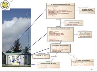
![O&M
OM_Observation
+ phenomenonTime
+ resultTime
+ validTime [0..1]
+ resultQuality [0..*]
+ parameter [0..*]
GF_PropertyType
GFI_Feature
OM_Process Any
+observedProperty
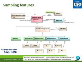
1
0..*
+featureOfInterest 1
0..*
+procedure1 +result
An Observation is an action whose result is an estimate of the value
of some property of the feature-of-interest, obtained using a specified procedure
AGU Fall 2013 | IN42A-01 | Cox | Leptoukh
Cox, OGC Abstract Specification – Topic 20: Observations and Measurements 2.0
ISO 19156:2011 Geographic Information – Observations and measurements14 |](https://image.slidesharecdn.com/in42a-01-coxleptoukh-150514050246-lva1-app6891/85/Observations-to-Information-14-320.jpg)


![OM_Observation
+ phenomenonTime
+ resultTime
+ validTime [0..1]
+ resultQuality [0..*]
+ parameter [0..*]
GFI_PropertyType
GFI_Feature
OM_ProcessGFI_DomainFeature Any
+observedProperty
1
+propertyValueProvider
0..*
+featureOfInterest
1
+generatedObservation
0..*
+procedure1 +result
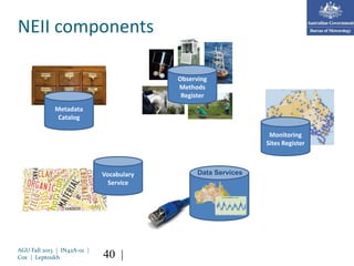
Range
observed property
Parameter dictionary
procedure
Register of sensors,
processes & algorithms
feature of interest
Feature-type catalogue
Feature service
result format:
GML, SWE,
netCDF, JSON, SQLite
...
Domain specialization
AGU Fall 2013 | IN42A-01 | Cox | Leptoukh21 |](https://image.slidesharecdn.com/in42a-01-coxleptoukh-150514050246-lva1-app6891/85/Observations-to-Information-21-320.jpg)

![WaterML2 specializes O&M
AGU Fall 2013 | IN42A-01 | Cox | Leptoukh
«FeatureType»
TimeseriesObservation
OM_Process
«FeatureType»
Procedures::
ObservationProcess
MD_Metadata
«Type»
ObservationMetadata
«FeatureType»
observation::OM_Observation
+ phenomenonTime :TM_Object
+ resultTime :TM_Instant
+ validTime :TM_Period [0..1]
+ resultQuality :DQ_Element [0..*]
+ parameter :NamedValue [0..*]
«FeatureType»
coverageObservation::
OM_DiscreteCoverageObservation
«FeatureType»
Timeseries (TVP) Observation::
TimeseriesTVPObservation
«FeatureType»
TimeseriesDomainRangeObservation
«FeatureTyp...
General Feature
Instance::
GFI_Feature
«metaclass»
General Feature Model::
GF_PropertyType
{root}
+ memberName :LocalName
+ definition :CharacterString
«FeatureType»
Timeseries::Timeseries
+metadata
0..1
+generatedObservation
0..*
+procedure
1
+propertyValueProvider
0..*
Domain
+featureOfInterest
1
0..*
+relatedObservation 0..*
Phenomenon
+observedProperty
1
Range +result
Name:
Package:
Version:
Author:
Context diagram: TimeseriesObservation
«RequirementsClass» Timeseries Observation
1.0
CSIRO
• Result is a time-series
• Observed-property
relates to water
24 |
• Key predecessors:
• CUAHSI WaterML
• WDTF](https://image.slidesharecdn.com/in42a-01-coxleptoukh-150514050246-lva1-app6891/85/Observations-to-Information-24-320.jpg)
![WaterML-WQ constrains
O&M and WaterML
AGU Fall 2013 | IN42A-01 | Cox | Leptoukh27 |
«FeatureType»
measurement::
OM_Measurement
AnyFeature
«FeatureType»
observ ation::OM_Observ ation
+ parameter :NamedValue [0..*]
+ phenomenonTime :TM_Object
+ resultQuality :DQ_Element [0..*]
+ resultTime :TM_Instant
+ validTime :TM_Period [0..1]
constraints
{observedProperty shall be a phenomenon associated with the feature of interest}
{procedure shall be suitable for observedProperty}
{result type shall be suitable for observedProperty}
{a parameter.name shall not appear more than once}
Units of Measure::Measure
{root}
+ value :Number
+ convert(UnitOfMeasure*) :Measure
«FeatureType»
General Feature
Instance::GFI_Feature
«metaclass»
General Feature Model::
GF_PropertyType
{root}
«metaclass»
General Feature Model::
GF_FeatureType
«FeatureType»
observation::
OM_Process
Metadata entity set
information::
MD_Metadata
«FeatureType»
cov erageObserv ation::
OM_DiscreteCov erageObserv ation
«FeatureType»
Timeseries Observ ation::
TimeseriesObserv ation
«FeatureType»
Timeseries (TVP) Observ ation::
TimeseriesTVPObserv ation
The XML element om:result SHALL have a uom property
that is an instance of the owl:Class
http://qudt.org/schema/qudt#Unit as defined in
http://resources.data.gov.au/water/def/water-quality/wq-
quantity.
The XML element om:observedProperty SHALL have
an xlink:href property that is an instance of the
http://qudt.org/schema/qudt#Quantity scheme as
defined in
http://resources.data.gov.au/water/def/water-
quality/wq-quantity.
The XML element om:featureOfInterest SHOULD have an xlink:href property that is an instance of
a GroundWaterML 1 GroundWaterBody feature or sub-type of HydrologicUnit feature as specified
in the XML schema at http://ngwd-bdnes.cits.nrcan.gc.ca/service/gwml/schemas/gwml.xsd
OR
The XML element om:featureOfInterest SHOULD have an xlink:href property that is an instance of
an OGC HY_Features HY_HydroFeature or sub-type as specified at "HY_Features: a Common
Hydrologic Feature Model Discussion Paper OGC 11-039r2"
«Type»
Measurement (TVP) Timeseries::
MeasurementTimeseriesTVP
Timeseries
«FeatureType»
Interleav ed (TVP) Timeseries::
TimeseriesTVP
TimeValuePair
«Type»
Measurement (TVP) Timeseries::
MeasureTimeValuePair
+ value :Measure
«FeatureType»
WQ_Measurement::
WQ_Measurement
«FeatureType»
WQ_MeasurementTimeSeriesTVPObserv ation::
WQ_MeasurementTimeSeriesTVPObserv ation
«FeatureType»
WQ_MeasurementTimeseriesTVP::
WQ_MeasurementTimeSeriesTVP
«metaclass»
WQ_Observ ation::
WQ_PropertyType
O&M Classes
WaterML 2 Classes
Water Quality Classes
Legend
+generatedObservation 0..*
ProcessUsed
+procedure
1
Phenomenon
+observedProperty
1
Metadata
+metadata 0..1
+result
Range
+collection
0..*CoverageFunction
+element
0..*
+result
0..*
+relatedObservation 0..*
+propertyValueProvider
0..*
Domain
+featureOfInterest
1
+carrierOfCharacteristics
0..*
+theGF_FeatureType
1
«instanceOf»
• Subject is a groundwater
or geofabric feature
• observed property is
water-quality property
• units of measure must match](https://image.slidesharecdn.com/in42a-01-coxleptoukh-150514050246-lva1-app6891/85/Observations-to-Information-27-320.jpg)

![36
12Z
7-May 9-May8-May6-May5-May
00Z00Z12Z00Z12Z12Z00Z12Z 00Z
result
forecast : OM_Observation
parameter.name = “analysisTime”
parameter.value = 2010-05-06T00:00Z
phenomenonTime.begin = 2010-05-06T00:00Z
phenomenonTime.end = 2010-05-09T12:00Z
resultTime = 2010-05-06T04:30Z
validTime [optional – not specified]
resultQuality [optional – not specified]
ISO19156 Observations and measurements:
also suitable for numerical simulations – including forecasts](https://image.slidesharecdn.com/in42a-01-coxleptoukh-150514050246-lva1-app6891/85/Observations-to-Information-36-320.jpg)

![ODM2
Procedure
Observed
property
Feature of Interest
result
Observation
OM_Observation
+ phenomenonTime
+ resultTime
+ validTime [0..1]
+ resultQuality [0..*]
+ parameter [0..*]
GF_PropertyType
GFI_Feature
OM_Process Any
+observedProperty
1
0..*
+featureOfInterest
1
0..*
+procedure1 +result
42](https://image.slidesharecdn.com/in42a-01-coxleptoukh-150514050246-lva1-app6891/85/Observations-to-Information-42-320.jpg)

![AGU Fall 2013 | IN42A-01 | Cox | Leptoukh
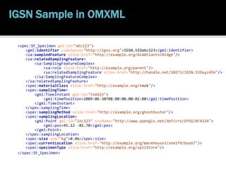
<http://handle.net/10273/IGSN.SIOabc123>
a sam:Specimen ;
rdfs:label "SIO specimen abc123"^^xsd:string ;
sam:currentLocation <http://example.org/various/Warehouse3/shelf9/box67> ;
sam:materialClass p1:rock ;
sam:preparationStep
[ sam:processOperator p1:JohnDoe ;
sam:processingDetails
<http://example.org/various/sf-process/jkl987> ;
sam:time <http://handle.net/10273/IGSN.SIOabc123/tim2> ] ;
sam:sampledFeature p1:midAtlanticRidge ;
sam:samplingFeatureComplex
[ sam:relatedSamplingFeature <igsn:SIOxyz456> ;
sam:role p1:parent ] ;
sam:samplingLocation
p1:loc123 ;
sam:samplingMethod <http://ldeo.columbia.edu/sampling/ghostbuster> ;
sam:samplingTime "2013-06-12T09:25:00.00+11:00"^^xsd:dateTime
sam:size [ basic:uom unit:kg ;
basic:value "0.46"^^basic:Number ] ;
sam:specimenType p1:splitCore .
IGSN Sample in RDF](https://image.slidesharecdn.com/in42a-01-coxleptoukh-150514050246-lva1-app6891/85/Observations-to-Information-45-320.jpg)
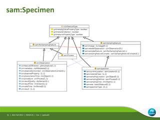
![AGU Fall 2013 | IN42A-01 | Cox | Leptoukh
class Specimen
SF_Specimen
+ currentLocation :Location [0..1]
+ materialClass :GenericName
+ samplingMethod :SF_Process [0..1]
+ samplingTime :TM_Object
+ specimenType :GenericName [0..1]
«estimatedProperty»
+ samplingLocation :GM_Object [0..1]
+ size :Measure [0..1]
SF_SamplingFeature
+ lineage :LI_Lineage [0..1]
+ parameter :NamedValue [0..*]
GFI_Feature
SamplingFeatureComplex
+ role :GenericName
PreparationStep
+ processOperator :CI_ResponsibleParty [0..1]
+ time :TM_Object
SF_Process
OM_Observation
SF_SamplingFeatureCollection
Design
+relatedObservation
0..*
+processingDetails
0..*
Intention
+sampledFeature
1..*
0..*
+relatedSamplingFeature
0..*
+member 1..*
Single model underlies
different implementations](https://image.slidesharecdn.com/in42a-01-coxleptoukh-150514050246-lva1-app6891/85/Observations-to-Information-46-320.jpg)
![Application of O&M
• Direct
• SOS + OMXML
– [Metadata for values from] data services
• Specializations
– WaterML2, WaterML-WQ, SoilML, SeaDataNet, INSPIRE, WMO ...
• Bridging vocabulary for integration
• TERENO (GFZ), NEII, ODM2, IGSN/SESAR, OBOE ...
• Checklist ...
• Slots for implicit explicit for x-domain use
AGU Fall 2013 | IN42A-01 | Cox | Leptoukh47 |](https://image.slidesharecdn.com/in42a-01-coxleptoukh-150514050246-lva1-app6891/85/Observations-to-Information-47-320.jpg)

![om:Observation
a :Class ;
rdfs:label "Observation"@en ;
rdfs:subClassOf gf:AnyFeature , h2o:FeatureType ;
:disjointWith om:Process ;
rdfs:subClassOf [ a :Restriction ; :cardinality "1"; :onProperty om:result ] ;
rdfs:subClassOf [ a :Restriction ; :cardinality "1"; :onProperty om:observedProperty ] ;
rdfs:subClassOf [ a :Restriction ; :cardinality "1"; :onProperty om:featureOfInterest ] ;
rdfs:subClassOf [ a :Restriction ; :cardinality "1"; :onProperty om:phenomenonTime ] ;
rdfs:subClassOf [ a :Restriction ; :cardinality "1"; :onProperty om:procedure ] ;
rdfs:subClassOf [ a :Restriction ; :cardinality "1"; :onProperty om:resultTime ] .
http://def.seegrid.csiro.au/isotc211/iso19156/2011/observation
AGU Fall 2013 | IN42A-01 | Cox | Leptoukh50 |
O&M in OWL2](https://image.slidesharecdn.com/in42a-01-coxleptoukh-150514050246-lva1-app6891/85/Observations-to-Information-50-320.jpg)
![AGU Fall 2013 | IN42A-01 | Cox | Leptoukh
OM_Observation
+ phenomenonTime
+ resultTime
+ validTime [0..1]
+ resultQuality [0..*]
+ parameter [0..*]
GF_PropertyType
GFI_Feature
OM_Process Any
+observedProperty
1
0..*
+featureOfInterest
1
0..*
+procedure1 +result
52 |
SSN ontology](https://image.slidesharecdn.com/in42a-01-coxleptoukh-150514050246-lva1-app6891/85/Observations-to-Information-52-320.jpg)


The document discusses the evolution and standardization of observation data in environmental science, emphasizing the need for data sharing and integration across various domains. It covers the historical context of observation standards, frameworks like ISO 19156, and specifications for data handling, including procedures and vocabularies. The aim is to enhance the usability of environmental data across multiple disciplines, enabling improved analysis and decision-making.