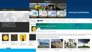
Plenary Presentation: Esri’s Public Safety Assistance Program—
How We Can Help You
Chris McIntosh, Esri
Jon Pedder, Esri
Desiree Kocis, GIS Coordinator, Massachusetts Emergency Management Agency
Planning for and Managing Emergencies (Incidents)
FEMA
Storm Threat to
Energy Infrastructure
U.S. Energy
Information
Administration
Interior Geospatial
Emergency Management
U.S. Department of the Interior
USGS
National Weather Service
Posted Warnings
Asia-Pacific Natural Disasters
Asia Pacific Region
Flood Planning
Documenting Storm Damage
U.S. Department of the Interior / Urban
Forestry Administration, Washington, DC
Hazard Map
VDEM
New York City, Jersey City
Risks from
Sea Level Rise
Standby Task Force / GIS Corps
Typhoon
Damage Assessment
Typhoon Response
Haiyan/Yolanda
World Vision
Esri Response: Disasters in 2014
MH-17 – Last day of UC 2014
Esri Response: Disasters in 2014
Napa Earthquake
Esri Response: Disasters in 2014
Hagupit/Ruby PH Rainfall (December 2014)
Esri Response: Disasters in 2014
Hagupit/Ruby PH Rainfall
Esri Response: Disasters in 2014
CA Floods (December 2014) – Pineapple Express
Esri Response: Disasters in 2014
CA Floods (December 2014) – Pineapple Express
Esri Response: Disasters in 2014
CA Floods (December 2014) – Pineapple Express
Flooding PIM
Dunsmuir, CA
Esri Response: Disasters in 2014
CA Floods (December 2014) – Pineapple Express
Esri Response: Disasters in 2015
Blizzard of 2015 (Jan. 26 – 27)
Esri Response: Disasters in 2015
Blizzard of 2015 (Jan. 26 – 27)
February 2015 – ISM
February 2015 – Forecast TIM
Esri Response: Disasters in 2015
Blizzard of 2015 (Jan. 26 – 27)
January 26, 2015 – Severe Weather PIM
January 26, 2015 – Forecast TIM
Esri Response: Disasters in 2015
Cyclone Pam
Esri Response: Disasters in 2015
Midwest Tornado
Esri Response: Disasters in 2015
Oil Spill – Santa Barbara, CA
Esri Response: Disasters in 2015
Alaska Wildfires
Supporting Special Events
Conferences/Conventions
Sporting Venues
Incidents/Events – A Common Problem
• Sharing static, dynamic and other data across organizations
and departments – shared situational awareness
• Integrating and analyzing data to provide actionable information
• Deploying mission-based (easy-to-use) applications
• Disseminating information to multiple devices
Similar Patterns
• Dissimilar events
- Boston Marathon, 35,000 runners, 26.2 miles
- Richmond Raceway (NASCAR), 400 acre site
Boston Marathon 2015
• Shared situational awareness between multiple agencies
- BRIC, MEMA, Boston City EOC
• True, real-time “common” operational data layers
• Critical information lost
• Hard to use
• Difficult to share and collaborate
• Not dynamic for current conditions
The Current State
The Future State
• Critical information displayed
• Easy to use
• Easy to share and collaborate
• Dynamic
www.esri.com/disaster
nss_12

nss_12