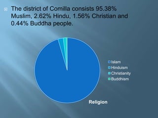















Comilla is located about 100 kilometers south east
of Dhaka.
It has a total area of 3085.17 square kilometers.
Comilla district has 5 municipalities,
54 wards,
148 mahallas,
12 upazilas,
1 thana,
180 union parishads,
2704 mouzas and
3624 villages.


Comilla (Town) stands on the bank of the Gumti river.



It is bounded by Burchigani and Tripura on the
north, Laksham and Chauddagram on the south
and Barura on the west. Major rivers passing through
Comilla include Gumti and Little Feni.


A population of 168378; male 52.56%, female
47.44%. Literacy rate among the
town people is 60.3%.
population
53.00%
52.00%
51.00%
50.00%
49.00%
48.00%
47.00%
46.00%
45.00%
44.00%

population

male

female


The district of Comilla consists 95.38%
Muslim, 2.62% Hindu, 1.56% Christian and
0.44% Buddha people.

Islam
Hinduism
Christianity
Buddhism

Religion








Main Crops: Paddy, jute, wheat, mustard
seed, brinjal. Extinct or nearly extinct crops
Linseed, sesame, sweet potato, china and
kaun.
Main Fruits:
Mango, jackfruit, banana, coconut, palm, guava
and blackberry.
Traditional Transport: Palanquin, horse
carriage, bullock cart, dhuri and bhari. These
means of transport are either extinct or nearly
extinct.
Main Export Items: Natural gas, khaddar
cloth, coconut, dry chilly, dry fish, egg, poultries
and potteries.




Comilla also has an Export Processing
Zone (EPZ) at the east end of the
town, established on the former site of an
airport.
It is one of the first growing EPZ(s) in
Bangladesh.Recently 2008 some occurrence
by BEPZA GM , 4 Running Factory layoff.




The Comilla region was once under
ancient Samatat and was joined
with Tripura State.
In the suburb there exists the Commonwealth War
Cemetery Memorials, Muktajuddha Museum at
Mainamati Cantonment and bangladesh academy
for rural development, Mainamati Museum, Comilla
Cadet College at Courtbari.

Thank You

My home district

  • 2.
              Comilla is locatedabout 100 kilometers south east of Dhaka. It has a total area of 3085.17 square kilometers. Comilla district has 5 municipalities, 54 wards, 148 mahallas, 12 upazilas, 1 thana, 180 union parishads, 2704 mouzas and 3624 villages.
  • 3.
     Comilla (Town) standson the bank of the Gumti river.  It is bounded by Burchigani and Tripura on the north, Laksham and Chauddagram on the south and Barura on the west. Major rivers passing through Comilla include Gumti and Little Feni.
  • 4.
     A population of168378; male 52.56%, female 47.44%. Literacy rate among the town people is 60.3%. population 53.00% 52.00% 51.00% 50.00% 49.00% 48.00% 47.00% 46.00% 45.00% 44.00% population male female
  • 5.
     The district ofComilla consists 95.38% Muslim, 2.62% Hindu, 1.56% Christian and 0.44% Buddha people. Islam Hinduism Christianity Buddhism Religion
  • 6.
        Main Crops: Paddy,jute, wheat, mustard seed, brinjal. Extinct or nearly extinct crops Linseed, sesame, sweet potato, china and kaun. Main Fruits: Mango, jackfruit, banana, coconut, palm, guava and blackberry. Traditional Transport: Palanquin, horse carriage, bullock cart, dhuri and bhari. These means of transport are either extinct or nearly extinct. Main Export Items: Natural gas, khaddar cloth, coconut, dry chilly, dry fish, egg, poultries and potteries.
  • 8.
      Comilla also hasan Export Processing Zone (EPZ) at the east end of the town, established on the former site of an airport. It is one of the first growing EPZ(s) in Bangladesh.Recently 2008 some occurrence by BEPZA GM , 4 Running Factory layoff.
  • 9.
      The Comilla regionwas once under ancient Samatat and was joined with Tripura State. In the suburb there exists the Commonwealth War Cemetery Memorials, Muktajuddha Museum at Mainamati Cantonment and bangladesh academy for rural development, Mainamati Museum, Comilla Cadet College at Courtbari.
  • 12.
  • 15.