Vegetation analysis of ngel nyaki forest reserve, mambilla plateau, nigeria
msf_uw_2013poster (1)
1. Introduction
Fire suppression and climate change have made the
forest more vulnerable to catastrophic wildfires and
less resilient to climate change in eastern
Washington. Today forest health poses many great
threats, making it a challenge to restoring these
ecosystems to their natural state. Collaboration
between federal, tribal, and private organizations is
key to the restoration of our Nations forests.
Through the use of GIS (Geographic Information
System) software, we can track the change of
forest structures.
Methodology
Results Conclusions
Future Directions
AcknowledgmentsArcGIS was used to compare and analyze changes
in forest density and composition. Map layers
were created from high-resolution aerial
photography from 1949, 1992, and 2009. Layers
where then overlaid to look for differentiations in
forest coverage. A one-100 meter buffer was
constructed around stream areas to see riparian
area coverage. Data tables were then constructed
to quantify the types of vegetation and forest type
coverage.
Defining Reference Conditions for
Restoration of Riparian Areas in Fire-Prone Forest Ecosystems
Mario S. Farias and Ernesto Alvarado
In this study GIS was used quantify the types of
vegetation surrounding riparian areas in the
Tapash Collaborative Forest Restoration between
the Okanogan-Wenatchee National Forest, the
Yakama Indian Nation, WA DNR, And NGOs. (figure
1) and to calculate vegetation coverage. Riparian
areas are valuable in forest ecosystems as they
serve to reduce the amount of soil erosion from
surrounding streams and rivers as well as serve as
a habitat for plant communities and animals.
Information found through this study will be used
to determine fire prevention methodologies and
help define future reference conditions for forest
management among these fires prone ecosystems
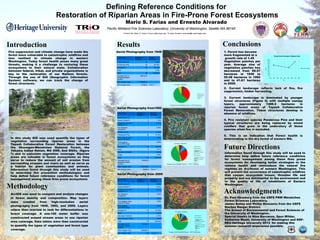
Figure 1
Cover Type Number of
polygons
Percent
Coverage
Pacific Silver Fir 10 5.19%
Ponderosa Pine 28 30.76%
Douglas Fir 40 56.35%
Rock 7 7.70%
Total 85 100.00%
Average size of
polygons(meters
square)
895722.9
Max Polygon Size 7230220.0
Min Polygon Size 87265.6
Cover Type Number of
polygons
Percent
Coverage
Pacific Silver Fir 7 3.13%
Grand/ White Fir 2 1.14%
Engelmann spruce -
subalpine Fir
9 5.37%
Dry Meadow/
Grassland
1 0.08%
Western Larch 1 0.14%
Ponderosa Pine 25 31.44%
Post logging- bare
ground, burned
5 1.60%
Post logging -
grass/forb stage
1 0.09%
Douglas Fir 65 46.54%
Rock 8 7.51%
Mountain Hemlock 2 0.90%
Water 1 2.05%
Total 127 100.00%
Average size of
polygons(meters
square)
554845.5
Max Polygon Size 8123120.0
Min Polygon Size 55585.6
Cover Type Number of
polygons
Percent
Coverage
Pacific Silver Fir 10 2.88%
Grand/ White Fir 2 0.94%
Engelmann spruce -
subalpine Fir
13 6.23%
Dry Meadow/
Grassland
5 7.96%
Ponderosa Pine 3 3.84%
Post logging- bare
ground, burned
4 1.89%
Post logging -
grass/forb stage
1 0.00%
Douglas Fir 116 61.68%
Rock 17 9.25%
Mountain Hemlock 3 2.70%
Wet meadow/ marsh 1 2.64%
Total 175 100.00%
Average size of
polygons(meters
square)
416125.1
Max Polygon Size 3409287.8
Min Polygon Size 9.9
Aerial Photography from 1949
Aerial Photography from1992
Aerial Photography from 2009
Information found through this study will be used to
determine help define future reference conditions
for forest management among these fires prone
ecosystems for developing better strategies to the
restore health and reintroduce the natural fire
regimes on dry-forest of eastern Washington. This
will prevent the occurrence of catastrophic wildfires
that causes ecosystem losses, threaten life and
property and are detrimental to the environment and
to the quality of life of inhabitants of Eastern
Washington.
2. Current landscape reflects lack of fire, fire
suppression, timber harvesting.
3. Current landscape is dominated by younger
forest structures (Figure 5) with multiple canopy
layers, approximately 1488.5 hectares in
riparian forest areas of Tapash Collaborative
Forest Restoration. These structures develop in
absence of wildfires.
4. Fire resistant species Ponderosa Pine and their
typical structures are being replaced by mixed
conifers that grow in the understory of those
species when fire is excluded.
5. This is an indication that Forest health is
deteriorating in the dry forest of eastern WA.
1. Forest has become
more fragmented at a
growth rate of 1.45
Vegetation patches per
year. Average size of
vegetation patches has
decreased from 89.57
hectares in 1949 to
55.48 hectares in 1992
and to 41.61 hectares
in 2009.
1940 1950 1960 1970 1980 1990 2000 2010 2020
0
500
1000
1500
2000
2500
3000
3500
4000
4500
5000
Young Forest Coverage in Riparian Area
YFMS coverage
Year
Hectare
Pacific Wildland Fire Sciences Laboratory, University of Washington, Seattle WA 98195
Dr. Paul Hessburg from the USFS PNW Wenatchee
Forest Sciences Laboratory.
James Bailey and Phillip Monsanto from the USFS
Naches Ranger District.
The School of Environmental and Forest Sciences of
the University of Washington.
Special thanks to Nina Barcenas, Spus Wilder,
Katherine Wyatt, University of Washington and NSF-
REU Heritage University 2013 for making this
summer research experience possible.
Contact info: Mario S. Farias: Fariasm1@heritage.edu ; Ernesto Alvarado: alvarado@u.washington.edu
Figure 2
Figure 3
Figure 4
Figure 5
Coverage,Composition
Pacific Silver Fir
Grand/ White Fir
Engelmann spruce-
subalpine Fir
Dry Meadow/ Grassland
Ponderosa Pine
Post logging- bare ground,
burned
Post logging- grass/ forb
stage
Douglas Fir
Rock
Young Forest Multiple Strata = 4473.4 hectares
Coverage, Composition
Pacific Silver Fir
Grand/ White Fir
Engelmann spruce-
subalpine Fir
Dry Meadow/ Grassland
Western Larch
Ponderosa Pine
Post logging- bare ground,
burned
Post logging- grass/forb
stage
Douglas Fir
Rock
Young Forest Multiple Strata = 2719.7 hectares
Coverage, Comparison
Pacific Silver Fir
Ponderosa Pine
Douglas Fir
Rock
Young Forest Multiple Strata= 3476.8 hectares