The memo discusses whether the High Frequency Active Auroral Research Program (HAARP) poses safety risks. HAARP uses electromagnetic waves to manipulate the ionosphere for research purposes. While the military claims it is only for research, some believe HAARP has the ability to control weather events like hurricanes and earthquakes. The facility was shut down in 2014 due to high operating costs of $800,000 for 10 days of full operations. The memo concludes there is not enough evidence to say whether HAARP poses risks, but recommends keeping it shut down due to expenses.
* What is H.A.A.R.P?
* How it Works?
* How it influence Our Society
* US Intelligence Behind this Technology
* Weather Modification is Happen Through This Technology
* New Communication System
* How the ionosphere can be converted into gaint Antenna
* Secret Project
The High Frequency Active Auroral Research Program (HAARP) is a joint military-civilian research program located in Alaska that studies the ionosphere and develops ionospheric enhancement technology. Some key points:
- HAARP was established in 1990 and became fully operational in 2007 to study the ionosphere and its importance for radio communication and plasma formation.
- The facility includes a high-power radio frequency transmitter that can temporarily excite a limited area of the ionosphere for research.
- While the stated goals are research, some conspiracy theories claim HAARP can manipulate weather or control minds. The secrecy around some aspects of the program has fueled speculation.
- HAARP was temporarily shut down in 2013
This research proposal examines the climate change and potential threat of weather weapons using the High Frequency Active Auroral Research Program (HAARP) technology. The proposal aims to 1) determine reasons for climate change, 2) increase understanding of HAARP for research purposes, and 3) explore communication applications of the technology. HAARP is described as using electromagnetic beams to heat the ionosphere and potentially enable weather modification for military purposes. Critics argue it could damage the environment or be used as a weapon. The proposal will research climate change factors and investigate HAARP's capabilities and criticisms.
This document provides an overview and objectives of a research proposal on climate change and weather weapons using HAARP technology. The proposal aims to understand HAARP and how it works to modify the ionosphere and potentially weather. It summarizes that HAARP can be used to change weather patterns, air pressure, temperatures, and cause earthquakes or floods according to predictions of scientists. The proposal outlines research methodologies and questions to focus on developing defenses against potential weapons and initiating research programs. Key terms like ionosphere and plasma are also defined.
Earth Control: Power, Resistance, and Deviance Within A Resource Empire Pano...Jason Lee Thompson
This document discusses issues related to monitoring and verification in international agreements on climate change and environmental protection. It describes how during the Cold War both the US and Soviet Union developed extensive surveillance networks to monitor the Earth and its inhabitants. However, some countries resist comprehensive monitoring as an infringement on sovereignty. The document explores potential technical solutions using networks of sensors and satellites to independently monitor countries' greenhouse gas emissions. It also discusses ongoing political challenges to reaching agreements, as some developing nations are wary of emissions reporting and caps, while climate change skeptics question the scientific consensus.
1) The document discusses the High Frequency Active Auroral Research Program (HAARP), a controversial military project that can manipulate the ionosphere and potentially be used as a weapon.
2) HAARP is capable of focusing electromagnetic energy into targeted regions of the ionosphere, which some scientists warn could disrupt communications or create weather effects.
3) The document raises concerns that HAARP could be used to manipulate weather as a weapon by altering upper atmosphere wind patterns and creating lenses that focus energy. Predictions from scientists suggest HAARP has the potential for dangerous and irreversible impacts.
Unmanned aircraft systems (UAS) were used to assess damage from a tornado in Morgan County, Alabama on March 31, 2016 as part of the VORTEX-Southeast field campaign. Two UAS platforms - a DJI S-1000 octocopter operated by NOAA and a fixed-wing UAS operated by a commercial group - captured high-resolution aerial imagery of the tornado's path. The imagery will help researchers compare observations and better understand the tornado's behavior through varying topography.
The document summarizes the HAARP program, which stands for High Frequency Active Auroral Research Program. It is located in Alaska and is the world's most capable high-power, high-frequency transmitter. The program was funded by the Air Force, Navy, University of Alaska Fairbanks, and DARPA to analyze the ionosphere and develop ionospheric enhancement technology. Some express concern that HAARP and related programs may be used against civilians. The document also discusses DARPA programs involving neural implants, radio frequency mapping, and investigating electromagnetic signaling between biological cells.
Dear Writer,Please do a PowerPoint presentation on my .docxrandyburney60861
Dear Writer,
Please do a PowerPoint presentation on my paper that was completed. I am attaching my paper so can have an idea what to do.
Please include speaker notes in the presentation.
Using PowerPoint develop a 22-slide presentation that demonstrates your mastery of the Program Outcomes by discussing the results of your Individual Project. The following slides should be presented:
1) Title Slide
2) Overview
3) Research Problem
4) Research Intent
5) Research Question(s)/Hypothesis
6) Literature Review Key Points
7) Methodology
8) Results
9) Conclusions
10) Recommendations
11) Summary
Chapter 1
Introduction
Preparation and response to natural disasters is a serious logistical challenge. Significant resources are used by intergovernmental, governmental, and non-governmental organizations to prepare and respond to the effects of natural disasters. When a natural disaster occurs, such organizations mobilize resources to respond. Recently, technological advancements in autonomous, semiautonomous, and unmanned vehicles have increased the utility of such vehicles while reducing costs. The increased use of UAVs has created a new dimension to Synthetic Aperture Radar (SAR) operations. In real life, the use of UAVs can be beneficial in cases where rapid decisions are required or the use of manpower is limited (Boehm et al., 2017).
Natural disasters have significantly damaged transportation infrastructure including railways and roads. Additionally, barrier lakes and landslides pose a serious threat to property and life in areas affected. When infrastructure is interrupted with heavy rescue equipment, rescue vehicles, suppliers and rescue teams face challenges to reach disaster-hit areas. As a result, efforts to provide humanitarian aid is hampered (Tatsidou et al., 2019). The traditional approaches of responding to natural disasters are unable to meet the requirements to support the process of disaster decision making. UAVs are well equipped to navigate areas affected by natural disasters and provide humanitarian aid.
This study aims to explore the viability of using the MQ-8B Fire Scout in providing humanitarian aid in areas affected by natural disasters. The document provides a literature review on the use of UAVs in providing humanitarian aid when natural disasters have occurred. The study compares the viability of using MQ-8B to MH-60 in conducting rescue operations in areas affected by disasters.
Significance of the Study
This study was conducted to determine the effectiveness of using UAVs in providing humanitarian aid in areas affected by natural disasters. The study assists in developing general knowledge and bridge the existing gap in providing humanitarian aid using UAVs. The findings of this study increase knowledge of the effectiveness of UAVs in responding to natural disasters and provide more insights on useful methods to respond to affected areas. Ultimately, these insights cou.
EXPLORE EARTH by John J. Murray | TROPICS Applications Workshop II, February ...Helen Gynell
The document discusses NASA's Earth Science Disasters Program and its efforts to promote the use of Earth observations to improve disaster prediction, preparedness, response, and recovery. It focuses on expanding partnerships to implement innovative Earth observation capabilities and develop decision-ready products. Examples are given of research projects funded by NASA that utilize remote sensing data and modeling to assess flood risk and impacts, monitor wildfires, and model fire behavior and smoke dispersion.
This document discusses drone technology and its various environmental applications. It begins with an overview of different types of drones based on size and function. It then outlines many potential uses of drones for environmental monitoring, such as assessing forest health, tracking wildlife, monitoring fires and pollution, and precision agriculture. The document also notes that drones can serve important early warning functions and be deployed quickly in disaster situations. While regulatory concerns exist around privacy and misuse, the document argues that drones can be effective environmental management tools when used for public benefit.
Use of Drones in Humanitarian Action and Disaster ManagementNepal Flying Labs
Presentation on the works carried out by WeRobotics and its Flying lab network during seminar series “Intrepid Solutions”, set up by Build Change and the Nepali Engineers’ Association (NEA) at its headquarter office in Pulchowk. Intrepid solution is an initiative to stimulate discussions between local practicing engineers, local researchers and international experts.
Environmental radioactivity, Audiovisual Introduction for kidsCesar Harada
Prepared by Cesar Harada for the Hong Kong Harbour School, Sept 6th 2014
Better google presentation with videos embedded : http://goo.gl/cKiFAE
Introduction to nuclear power, weapons and radioactive pollution in the environment for school kids. No science background required. We are trying to address the questions and anxieties kids may have about the nuclear power. We explain how we can contribute to a better understanding of radioactivity in the environment from a citizen science perspective.
CAUTION : some concepts and images may be shocking if not explained appropriately.
contact@cesarharada.com
Creative Commons 3.0 international, Attribution, Sharealike
This document discusses the role of remote sensing and GIS in disaster management. It begins with an introduction to disaster management cycles and then describes how remote sensing is used across different stages of disasters like cyclones, earthquakes, and floods for tasks such as early warning, damage assessment, and recovery planning. It provides examples of various satellites used for monitoring different disasters. The document emphasizes that while hazards cannot be prevented, remote sensing can play a key role in minimizing loss of life through preparedness, response, and rebuilding efforts after disasters strike.
This document summarizes Peter Guest's research using a miniature quad-rotor unmanned aerial system (MQRUAS) to take meteorological measurements over the Arctic Ocean. Some key points:
- Guest and students used an MQRUAS equipped with a radiosonde to measure temperature, humidity, and pressure in the lower atmosphere. Tests showed the measurements were sufficiently accurate for scientific study.
- During an Arctic research cruise, Guest conducted the first known MQRUAS flights in the polar region to study atmospheric conditions near sea ice and ocean surfaces. A total of 18 flights were performed from the research vessel and ice floes.
- While some issues with icing and compass errors occurred, the meteorological data
This article discusses a study that forecast future UAS flight volume in the NAS. It found that about 26,312 UAS flights per day could be expected from missions like wildfire monitoring, weather data collection, air quality monitoring, and others. Adding these flights would increase total NAS traffic by 55%, challenging the current air traffic control system. Long-duration and vertical flights would reduce sector capacity. UAS also have different performance characteristics than piloted aircraft, further increasing controller workload. Changes to traffic management and NAS architecture may be needed to safely integrate high volumes of UAS flights.
The document discusses the benefits of space exploration and argues for increasing funding for NASA. It notes that NASA's budget has declined significantly since the 1960s but that space exploration has inspired many scientists and led to important discoveries. Furthermore, it outlines how NASA research has resulted in useful technologies and stimulated jobs and education in STEM fields. The document concludes that in order to continue making progress on issues like climate change, more funding for NASA and space agencies is needed to support further innovation.
N A S A Supporting Earth System Science 2005Peerasak C.
1) NASA's Jason and TOPEX/Poseidon satellites serendipitously recorded the first detailed measurements of the 2004 Indian Ocean tsunami as it passed through the Bay of Bengal, detecting half-meter changes in sea surface height.
2) These observations are helping scientists better understand tsunami wave propagation and behavior to improve computer models for predicting tsunami impacts.
3) While satellites cannot provide timely tsunami warnings, increased ocean monitoring buoys combined with strong public education programs will be key to establishing effective tsunami warning systems.
The document summarizes the 1986 Chernobyl nuclear disaster. On April 26, 1986, reactors at the Chernobyl nuclear power plant in Ukraine exploded during a safety test, releasing radioactive material into the atmosphere. It was one of the worst nuclear accidents in history. The explosion exposed millions of people to radiation and caused widespread health and environmental impacts across Ukraine, Belarus, Russia, and farther abroad. Over time, the accident led to thousands of deaths from radiation exposure and is estimated to have caused cancer in thousands more people. The disaster highlighted issues with the Soviet nuclear industry and had long lasting social and economic consequences for the region.
PRESS RELEASE CONFERENCE TO ASSESS THE IMPACT RISK FROM ASTEROIDS AND COMETS ...Fundacion ACCION 13
The 2019 IAA Planetary Defense Conference will bring together world experts from April 29 to May 3, 2019 in Washington D.C. to discuss potentially hazardous asteroids and comets and ways to defend Earth from a collision. They will examine asteroid 99942 Apophis, which poses a serious threat when it passes closely in 2029. The conference will also include an exercise involving a fictional 100-300 meter asteroid with a 1% chance of impacting Earth in 2027 to discuss response and deflection strategies. Experts will present information on asteroid detection and characterization, mission designs, deflection techniques, and impact consequences to improve planetary defense preparedness.
This document discusses the potential for drones, or unmanned aerial vehicles (UAVs), to be used for good purposes beyond commercial applications. It outlines some current uses of drones in areas like agriculture, public safety, environmental monitoring, and disaster response. It also describes an organization called DronesForGood that aims to promote the safe and responsible use of drones for humanitarian, environmental, and social applications through research, education, and public outreach.
EXPLORING THE EFFECTIVENESS OF THE MQ-8B FIRE SCOUT TO PROVISION H.docxlmelaine
This document is a graduate capstone project submitted by Henry Vascones to Embry-Riddle Aeronautical University in partial fulfillment of a Master of Science in Aeronautics degree in 2020. The project explores the effectiveness of using the MQ-8B Fire Scout unmanned aerial vehicle to provide humanitarian aid in areas affected by natural disasters. The literature review discusses previous research on the origins and applications of UAVs, their use for cargo delivery, and the impacts of weather on UAV operations. The study aims to determine if UAVs like the MQ-8B provide a more expedient and cost-effective means of delivering humanitarian aid compared to traditional manned aircraft like the MH-60 Sea Hawk. It
EXPLORING THE EFFECTIVENESS OF THE MQ-8B FIRE SCOUT TO PROVISION H.docxmecklenburgstrelitzh
EXPLORING THE EFFECTIVENESS OF THE MQ-8B FIRE SCOUT TO PROVISION HUMANITARIAN EFFORTS POST NATURAL DISASTERS
by
Henry Vascones
A Graduate Capstone Project Submitted to the College of Aeronautics,
Department of Graduate Studies, in Partial Fulfillment
of the Requirements for the Degree of
Master of Science in Aeronautics
Embry-Riddle Aeronautical University
Worldwide Campus
March 2020
1
EXPLORING THE EFFECTIVENESS OF THE MQ-8B FIRE SCOUT TO PROVISION HUMANITARIAN EFFORTS POST NATURAL DISASTERS
by
Henry Vascones
This Graduate Capstone Project was prepared under the direction of the candidate’s
Graduate Capstone Project Chair, Dr. Jeremy Hodges,
Worldwide Campus, and has been approved. It was submitted to the
Department of Graduate Studies in partial fulfillment
of the requirements for the degree of
Master of Science in Aeronautics
Graduate Capstone Project:
_________________________________________
Jeremy Hodges, PhD.
Graduate Capstone Project Chair
March 2020
II
Acknowledgements
I would like to thank those who assisted and guided me throughout my time in the master’s program at Embry-Riddle Aeronautical University Worldwide.
III
Abstract
Scholar: Henry Vascones
Title: Exploring the Effectiveness of the MQ-8B Fire Scout to provision Humanitarian Efforts Post Natural Disasters
Institution: Embry-Riddle Aeronautical University
Degree: Master of Science in Aeronautics
Year: 2020
This study will explore the Unmanned Aerial Vehicles (UAVs) have been increasingly used for providing humanitarian aid during natural disasters. This study will evaluate the effectiveness of the Northrop Grumman MQ-8B Fire Scout in providing humanitarian aid after natural disasters have occurred. The ability to utilize the MQ-8B will be analyzed by determining their ability to conduct humanitarian in areas affected by natural disasters and are largely inaccessible using the existing traditional methods. The viability of using UAVs in such operations in terms of abilities and costs will be compared to using response utility trucks. The study will determine the viability of using UAVs in responding to natural disasters while at the same time providing economic benefits. The use of UAVs will be compared to existing response approaches such as the use of emergency response utility vehicles and manned flight. The study will also develop a model to show the costs and benefits of utilizing MQ-8B in responding to natural disasters. A quantitative approach will be used to collect data from existing literature. Information will be obtained from various sources including the Insurance Information Institute, Federal Aviation Administration (FAA), National Center for Biotechnology Information (NCBI), Occupational Safety and Health Administration (OSHA), and the Transportation Research Board on UAVs and manned systems to help come up with a solution to these problems
IV
Table of Contents
Page
Graduate Capstone Project Com.
EXPLORING THE EFFECTIVENESS OF THE MQ-8B FIRE SCOUT TO PROVISION H.docx
Memo
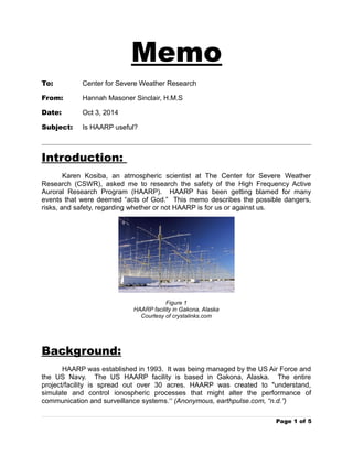
1. Memo
To: Center for Severe Weather Research
From: Hannah Masoner Sinclair, H.M.S
Date: Oct 3, 2014
Subject: Is HAARP useful?
Introduction:
Karen Kosiba, an atmospheric scientist at The Center for Severe Weather
Research (CSWR), asked me to research the safety of the High Frequency Active
Auroral Research Program (HAARP). HAARP has been getting blamed for many
events that were deemed “acts of God.” This memo describes the possible dangers,
risks, and safety, regarding whether or not HAARP is for us or against us.
Figure 1
HAARP facility in Gakona, Alaska
Courtesy of crystalinks.com
Background:
HAARP was established in 1993. It was being managed by the US Air Force and
the US Navy. The US HAARP facility is based in Gakona, Alaska. The entire
project/facility is spread out over 30 acres. HAARP was created to "understand,
simulate and control ionospheric processes that might alter the performance of
communication and surveillance systems.” (Anonymous, earthpulse.com, “n.d.”)
Page 1 of 5
2. Hannah Sinclair, Sept 12, 2014, Page 2
Image 2
Ariel View of HAARP
Courtesy of superforce.com
HAARP uses electromagnetic frequencies to manipulate a targeted area of the
ionosphere.
HAARP requires “$300,000 a month just to keep the facility open and $500,000 to run it
at full capacity for 10 days.” (James Keeney, HAARP's program manager, arrl.org, July
15,2013)
HAARP was developed to “...investigate the potential for developing ionospheric
enhancement technology for radio communications and surveillance.” (Anonymous,
beforeitsnews.com, April 15, 2013)
Highlights:
“According to the official HAARP website, “HAARP is a scientific endeavor
aimed at studying the properties and behavior of the ionosphere, with particular
emphasis on being able to understand and use it to enhance communications and
surveillance systems for both civilian and defense purposes.”” (Fred Burks, HAARP:
Secret Weapon Used For Weather Modification, Electromagnetic Warfare,
globalresearch.com, July 23, 2013 ) Although, HAARP was created to advance the
communication systems, such as radio communication and surveillance systems, the
previous statement has left many people wondering what kind of defense purposes
might HAARP be affiliated with. There has been little to no evidence that HAARP is
anything more than what has been reported.
Page 2 of 5
3. Hannah Sinclair, Sept 12, 2014, Page 3
Many civilians fear that HAARP is more than what meets the eye. It has been
said that HAARP has the power and capacity to control the weather and such events
as: the 2012 Hurricane Sandy and the 2010 Haiti earthquake. “... President Hugo
Chavez -- have added HAARP to their list of theoretical ways the U.S. could have
caused the Haiti earthquake.” (Bill Roth, Earthquakes, HAARP and conspiracy theories,
and.com, January 20, 2010 )
“By pouring measured energy that has been focused into certain parts
of the ionosphere, scientists can create all kinds of storms like
hurricanes, thunderstorms, floods, tornadoes, and drought.”
(Anonymous; cuttingedge.org,”n.d.” )
image 4 image 5
Doppler view of Hurricane Sandy Aftermath of the Haiti earthquake
Courtesy of cnn.com Courtesy of googleimages.com
Politically, the military denies all aspects of HAARP being able to control the
weather, but HAARP is gaining a lot of attention around the globe.
“Splashy web postings abound, blaming HAARP for controlling the
weather — most recently in the case of Hurricane Sandy and the spate
of tornados — and for causing other natural disasters. Quipped
Keeney, “If I actually could affect the weather, I’d keep it open.”
“(James Keeney, HAARP's program manager; arrl.org, July 15, 2013)
Page 3 of 5
4. Hannah Sinclair, Sept 12, 2014, Page 4
Whether or not people believe what HARRP essentially is or is not is up to them,
but the cost of running such a facility is alarming, considering it does not seem to be a
necessity. As mentioned above, the facility requires a lot of funding to run at full
capacity, $800,000 to be exact, for 10 days at maximum capacity.
Due to the high cost of the facility, it has been shut down as of last May. When
discussing HAARP, David Walker, an Air Force official said: “After 21 years of
experiments, the controversial HAARP project is no longer “an area that we have any
need for in the future.” (David Walker, rt.com, May 27, 2014) It was stated in the same
article that: “Although the HAARP installation is two decades old, it is still operable and
could be used for scientific research, but most probably not at the expense of the US
military struggling to reduce spending.” (Anonymous, rt.com, May 27, 2014)
Lastly, HAARPs effects on our planet and it's inhabitants is still unknown. It has
been speculated by the president of the International Institute of Concern for Public
Health that: “HAARP operates as ‘a gigantic heater that can cause major disruptions in
the ionosphere, creating not just holes, but long incisions in the protective layer that
keeps deadly radiation from bombarding the planet’. “ (Rosalie Bertell, Weather
Warfare: Beware the US Military’s Experiments with Climatic Warfare,
globalresearch.com, June 29, 2014)
Conclusion:
There is not enough publically accessible, concrete evidence to support or
disband the support of HAARP. The cost of running the facility outweighs the benefits to
the facility's research currently. However, there is no conclusive evidence that suggests
HAARP is a danger in anyway. I cannot say that the program is safe or not because
there is not enough conclusive evidence, but I can say that it is my personal opinion that
the program remain shut down, strictly due to its operating cost.
Works Cited:
Anonymous (“n.d.”). Haarp.array1,jpg. Sept. 11, 2014. <http://www.crystalinks.com/haarp.array1.jpg>
Anonymous (“n.d”). HAARP-3.jpg. Sept. 11, 2014. <http://www.superforce.com/haarp/HAARP-3.jpg>
Roth, Bill (Jan 20, 2010). Earthquakes, HAARP, and Conspiracy Theories. Sept 11, 2014.
<http://www.adn.com/article/20100120/earthquakes-haarp-and-conspiracy-theories>
Bertell, Rosalie (“n.d.”) Background of the HAARP Project. Sept 11, 2014.
<http://www.earthpulse.com/src/subcategory.asp?catid=1&subcatid=1>
Page 4 of 5
5. Hannah Sinclair, Sept 12, 2014, Page 5
Unknown (July 15, 2013). HAARP Facility Shuts Down. Sept 11, 2014. <http://www.arrl.org/news/haarp-facility-
shuts-down>
Unknown (Apr 05, 2013). “H.A.A.R.P” Technology Fully Explained. Sept 12, 2014.
<http://beforeitsnews.com/alternative/2013/04/h-a-a-r-p-technology-fully-explained-2612774.html>
Burks, Fred (July 23, 2013). HAARP:Secret Weapon Used For Weather Modification, Electromagnetic
Warfare. Spet 12, 2014. <http://www.globalresearch.ca/haarp-secret-weapon-used-for-weather-modification-
electromagnetic-warfare/20407>
Anonymous (“n.d.”). A TERRIFYING LOOK AT THE CONTROL OF WEATHER WARFARE -- A LOOK AT
HAARP . Spet 12, 2014. <http://www.cuttingedge.org/news/n1207.cfm>
Smith, Matt (Oct 30, 2012). Sandy wreaks havoc across Northeast; at least 11 dead. Sept 12, 2014.
<http://www.cnn.com/2012/10/29/us/tropical-weather-sandy/>
Anonymous (“n.d.”. Haiti Earthqauke.jpg Sept 12, 2014. <https://www.google.com/search?
q=haiti+earthquake&biw=1440&bih=763&source=lnms&tbm=isch&sa=X&ei=OyUTVL_dN479oQSO64H4
Bg&ved=0CAgQ_AUoAQ#facrc=_&imgdii=_&imgrc=CHWRGYdo7Pvz_M%253A%3BpbgJ7pqUx3HwsM
%3Bhttp%253A%252F%252Fkosmix.co%252Fstatic%252F0736f983c40fc513e35b3c079a2eaa0d.jpg
%3Bhttp%253A%252F%252Fm.kosmix.co%252Fhaiti-earthquake%252F%3B990%3B633>
Anonymous (May 27, 2014). Research center or weather weapon? US military is shutting down HAARP.
Sept 12, 2014. <http://rt.com/news/161672-haarp-closure-weather-experiments/>
Chossudovsky, Michel (Dec 2007). Weather Warfare: Beware the US Military’s Experiments with Climatic
Warfare. Sept 12, 2014. <http://www.globalresearch.ca/weather-warfare-beware-the-us-military-s-experiments-
with-climatic-warfare/7561>
Page 5 of 5
6. Hannah Sinclair, Sept 12, 2014, Page 5
Unknown (July 15, 2013). HAARP Facility Shuts Down. Sept 11, 2014. <http://www.arrl.org/news/haarp-facility-
shuts-down>
Unknown (Apr 05, 2013). “H.A.A.R.P” Technology Fully Explained. Sept 12, 2014.
<http://beforeitsnews.com/alternative/2013/04/h-a-a-r-p-technology-fully-explained-2612774.html>
Burks, Fred (July 23, 2013). HAARP:Secret Weapon Used For Weather Modification, Electromagnetic
Warfare. Spet 12, 2014. <http://www.globalresearch.ca/haarp-secret-weapon-used-for-weather-modification-
electromagnetic-warfare/20407>
Anonymous (“n.d.”). A TERRIFYING LOOK AT THE CONTROL OF WEATHER WARFARE -- A LOOK AT
HAARP . Spet 12, 2014. <http://www.cuttingedge.org/news/n1207.cfm>
Smith, Matt (Oct 30, 2012). Sandy wreaks havoc across Northeast; at least 11 dead. Sept 12, 2014.
<http://www.cnn.com/2012/10/29/us/tropical-weather-sandy/>
Anonymous (“n.d.”. Haiti Earthqauke.jpg Sept 12, 2014. <https://www.google.com/search?
q=haiti+earthquake&biw=1440&bih=763&source=lnms&tbm=isch&sa=X&ei=OyUTVL_dN479oQSO64H4
Bg&ved=0CAgQ_AUoAQ#facrc=_&imgdii=_&imgrc=CHWRGYdo7Pvz_M%253A%3BpbgJ7pqUx3HwsM
%3Bhttp%253A%252F%252Fkosmix.co%252Fstatic%252F0736f983c40fc513e35b3c079a2eaa0d.jpg
%3Bhttp%253A%252F%252Fm.kosmix.co%252Fhaiti-earthquake%252F%3B990%3B633>
Anonymous (May 27, 2014). Research center or weather weapon? US military is shutting down HAARP.
Sept 12, 2014. <http://rt.com/news/161672-haarp-closure-weather-experiments/>
Chossudovsky, Michel (Dec 2007). Weather Warfare: Beware the US Military’s Experiments with Climatic
Warfare. Sept 12, 2014. <http://www.globalresearch.ca/weather-warfare-beware-the-us-military-s-experiments-
with-climatic-warfare/7561>
Page 5 of 5