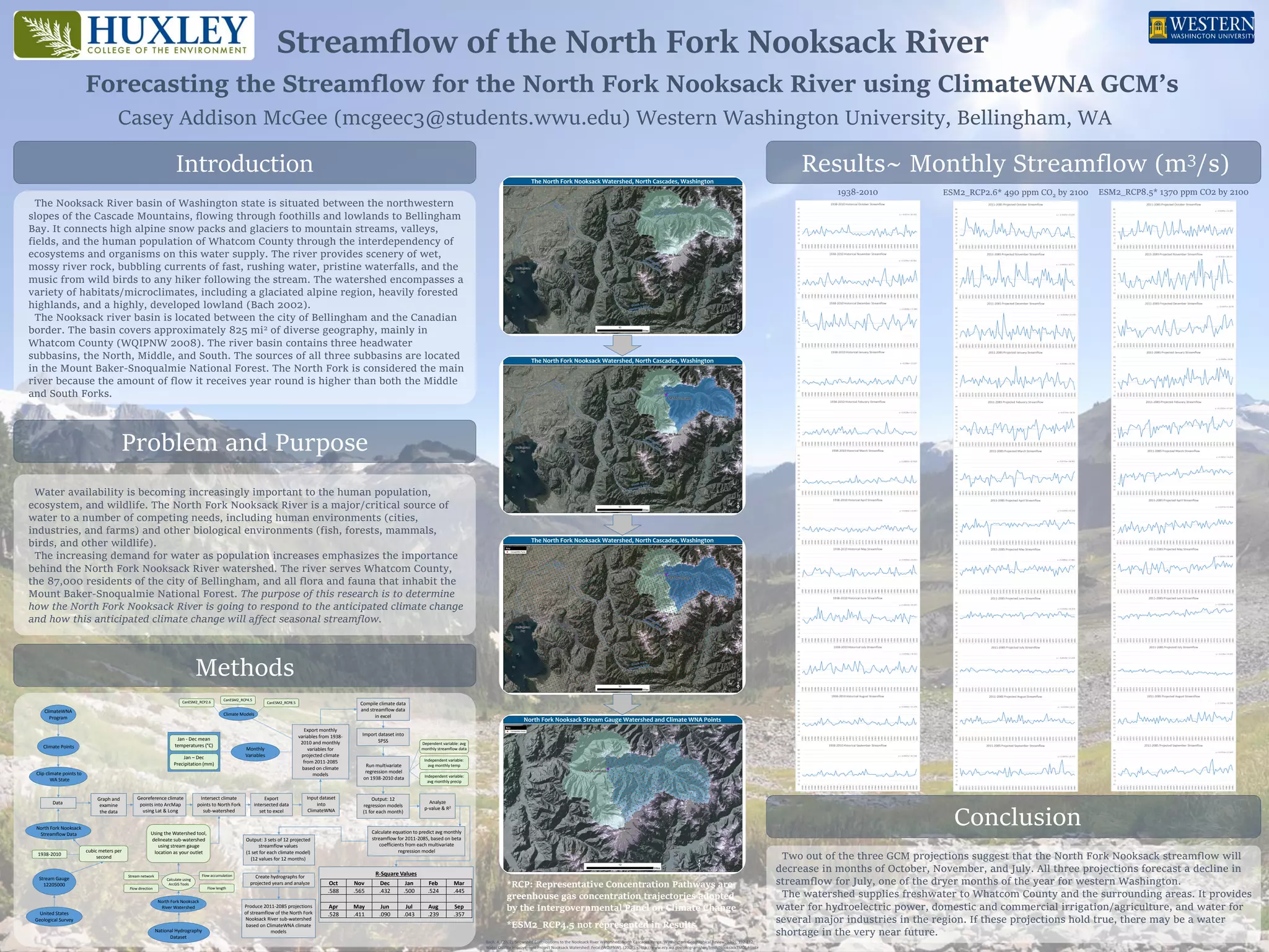
Streamflow of the North Fork Nooksack River
Forecasting the Streamflow for the North Fork Nooksack River using ClimateWNA GCM’s
Casey Addison McGee (mcgeec3@students.wwu.edu) Western Washington University, Bellingham, WA
Introduction
Methods
Results~ Monthly Streamflow (m3/s)
Conclusion
Problem and Purpose
Water availability is becoming increasingly important to the human population,
ecosystem, and wildlife. The North Fork Nooksack River is a major/critical source of
water to a number of competing needs, including human environments (cities,
industries, and farms) and other biological environments (fish, forests, mammals,
birds, and other wildlife).
The increasing demand for water as population increases emphasizes the importance
behind the North Fork Nooksack River watershed. The river serves Whatcom County,
the 87,000 residents of the city of Bellingham, and all flora and fauna that inhabit the
Mount Baker-Snoqualmie National Forest. The purpose of this research is to determine
how the North Fork Nooksack River is going to respond to the anticipated climate change
and how this anticipated climate change will affect seasonal streamflow.
ESM2_RCP2.6* 490 ppm CO2 by 21001938-2010 ESM2_RCP8.5* 1370 ppm CO2 by 2100
North Fork Nooksack
Streamflow Data
Data
Jan - Dec mean
temperatures (°C)
Jan – Dec
Precipitation (mm)
ClimateWNA
Program
cubic meters per
second
1938-2010
Stream Gauge
12205000
Climate Points
Clip climate points to
WA State
Output: 3 sets of 12 projected
streamflow values
(1 set for each climate model)
(12 values for 12 months)
Graph and
examine
the data
CanESM2_RCP2.6
CanESM2_RCP4.5
CanESM2_RCP8.5
Intersect climate
points to North Fork
sub-watershed
Georeference climate
points into ArcMap
using Lat & Long
Using the Watershed tool,
delineate sub-watershed
using stream gauge
location as your outlet
National Hydrography
Dataset
Flow direction
Flow accumulationStream network
Flow length
North Fork Nooksack
River Watershed
Calculate using
ArcGIS Tools
Climate Models
Export
intersected data
set to excel
Input dataset
into
ClimateWNA
Export monthly
variables from 1938-
2010 and monthly
variables for
projected climate
from 2011-2085
based on climate
models
Monthly
Variables
Compile climate data
and streamflow data
in excel
Import dataset into
SPSS
Run multivariate
regression model
on 1938-2010 data
Dependent variable: avg
monthly streamflow data
Independent variable:
avg monthly temp
Independent variable:
avg monthly precip
Output: 12
regression models
(1 for each month)
Analyze
p-value & R2
Calculate equation to predict avg monthly
streamflow for 2011-2085, based on beta
coefficients from each multivariate
regression model
Create hydrographs for
projected years and analyze
Produce 2011-2085 projections
of streamflow of the North Fork
Nooksack River sub-watershed
based on ClimateWNA climate
models
United States
Geological Survey
Two out of the three GCM projections suggest that the North Fork Nooksack streamflow will
decrease in months of October, November, and July. All three projections forecast a decline in
streamflow for July, one of the dryer months of the year for western Washington.
The watershed supplies freshwater to Whatcom County and the surrounding areas. It provides
water for hydroelectric power, domestic and commercial irrigation/agriculture, and water for
several major industries in the region. If these projections hold true, there may be a water
shortage in the very near future.
The Nooksack River basin of Washington state is situated between the northwestern
slopes of the Cascade Mountains, flowing through foothills and lowlands to Bellingham
Bay. It connects high alpine snow packs and glaciers to mountain streams, valleys,
fields, and the human population of Whatcom County through the interdependency of
ecosystems and organisms on this water supply. The river provides scenery of wet,
mossy river rock, bubbling currents of fast, rushing water, pristine waterfalls, and the
music from wild birds to any hiker following the stream. The watershed encompasses a
variety of habitats/microclimates, including a glaciated alpine region, heavily forested
highlands, and a highly, developed lowland (Bach 2002).
The Nooksack river basin is located between the city of Bellingham and the Canadian
border. The basin covers approximately 825 mi2 of diverse geography, mainly in
Whatcom County (WQIPNW 2008). The river basin contains three headwater
subbasins, the North, Middle, and South. The sources of all three subbasins are located
in the Mount Baker-Snoqualmie National Forest. The North Fork is considered the main
river because the amount of flow it receives year round is higher than both the Middle
and South Forks.
R-Square Values
Oct Nov Dec Jan Feb Mar
.588 .565 .432 .500 .524 .445
Apr May Jun Jul Aug Sep
.528 .411 .090 .043 .239 .357
*RCP: Representative Concentration Pathways are
greenhouse gas concentration trajectories adopted
by the Intergovernmental Panel on Climate Change
*ESM2_RCP4.5 not represented in Results
Bach, A. (2002). Snowshed Contributions to the Nooksack River Watershed, North Cascades Range, Washington. Geographical Review, 92(2), 192-212.
Water Quality Improvement Project Nooksack Watershed: Fecal (WQIPNW). (2008). <http://www.ecy.wa.gov/programs/wq/tmdl/NooksackTMDL.html>

McGee_Final_Poster

  • 1.
    Streamflow of theNorth Fork Nooksack River Forecasting the Streamflow for the North Fork Nooksack River using ClimateWNA GCM’s Casey Addison McGee (mcgeec3@students.wwu.edu) Western Washington University, Bellingham, WA Introduction Methods Results~ Monthly Streamflow (m3/s) Conclusion Problem and Purpose Water availability is becoming increasingly important to the human population, ecosystem, and wildlife. The North Fork Nooksack River is a major/critical source of water to a number of competing needs, including human environments (cities, industries, and farms) and other biological environments (fish, forests, mammals, birds, and other wildlife). The increasing demand for water as population increases emphasizes the importance behind the North Fork Nooksack River watershed. The river serves Whatcom County, the 87,000 residents of the city of Bellingham, and all flora and fauna that inhabit the Mount Baker-Snoqualmie National Forest. The purpose of this research is to determine how the North Fork Nooksack River is going to respond to the anticipated climate change and how this anticipated climate change will affect seasonal streamflow. ESM2_RCP2.6* 490 ppm CO2 by 21001938-2010 ESM2_RCP8.5* 1370 ppm CO2 by 2100 North Fork Nooksack Streamflow Data Data Jan - Dec mean temperatures (°C) Jan – Dec Precipitation (mm) ClimateWNA Program cubic meters per second 1938-2010 Stream Gauge 12205000 Climate Points Clip climate points to WA State Output: 3 sets of 12 projected streamflow values (1 set for each climate model) (12 values for 12 months) Graph and examine the data CanESM2_RCP2.6 CanESM2_RCP4.5 CanESM2_RCP8.5 Intersect climate points to North Fork sub-watershed Georeference climate points into ArcMap using Lat & Long Using the Watershed tool, delineate sub-watershed using stream gauge location as your outlet National Hydrography Dataset Flow direction Flow accumulationStream network Flow length North Fork Nooksack River Watershed Calculate using ArcGIS Tools Climate Models Export intersected data set to excel Input dataset into ClimateWNA Export monthly variables from 1938- 2010 and monthly variables for projected climate from 2011-2085 based on climate models Monthly Variables Compile climate data and streamflow data in excel Import dataset into SPSS Run multivariate regression model on 1938-2010 data Dependent variable: avg monthly streamflow data Independent variable: avg monthly temp Independent variable: avg monthly precip Output: 12 regression models (1 for each month) Analyze p-value & R2 Calculate equation to predict avg monthly streamflow for 2011-2085, based on beta coefficients from each multivariate regression model Create hydrographs for projected years and analyze Produce 2011-2085 projections of streamflow of the North Fork Nooksack River sub-watershed based on ClimateWNA climate models United States Geological Survey Two out of the three GCM projections suggest that the North Fork Nooksack streamflow will decrease in months of October, November, and July. All three projections forecast a decline in streamflow for July, one of the dryer months of the year for western Washington. The watershed supplies freshwater to Whatcom County and the surrounding areas. It provides water for hydroelectric power, domestic and commercial irrigation/agriculture, and water for several major industries in the region. If these projections hold true, there may be a water shortage in the very near future. The Nooksack River basin of Washington state is situated between the northwestern slopes of the Cascade Mountains, flowing through foothills and lowlands to Bellingham Bay. It connects high alpine snow packs and glaciers to mountain streams, valleys, fields, and the human population of Whatcom County through the interdependency of ecosystems and organisms on this water supply. The river provides scenery of wet, mossy river rock, bubbling currents of fast, rushing water, pristine waterfalls, and the music from wild birds to any hiker following the stream. The watershed encompasses a variety of habitats/microclimates, including a glaciated alpine region, heavily forested highlands, and a highly, developed lowland (Bach 2002). The Nooksack river basin is located between the city of Bellingham and the Canadian border. The basin covers approximately 825 mi2 of diverse geography, mainly in Whatcom County (WQIPNW 2008). The river basin contains three headwater subbasins, the North, Middle, and South. The sources of all three subbasins are located in the Mount Baker-Snoqualmie National Forest. The North Fork is considered the main river because the amount of flow it receives year round is higher than both the Middle and South Forks. R-Square Values Oct Nov Dec Jan Feb Mar .588 .565 .432 .500 .524 .445 Apr May Jun Jul Aug Sep .528 .411 .090 .043 .239 .357 *RCP: Representative Concentration Pathways are greenhouse gas concentration trajectories adopted by the Intergovernmental Panel on Climate Change *ESM2_RCP4.5 not represented in Results Bach, A. (2002). Snowshed Contributions to the Nooksack River Watershed, North Cascades Range, Washington. Geographical Review, 92(2), 192-212. Water Quality Improvement Project Nooksack Watershed: Fecal (WQIPNW). (2008). <http://www.ecy.wa.gov/programs/wq/tmdl/NooksackTMDL.html>