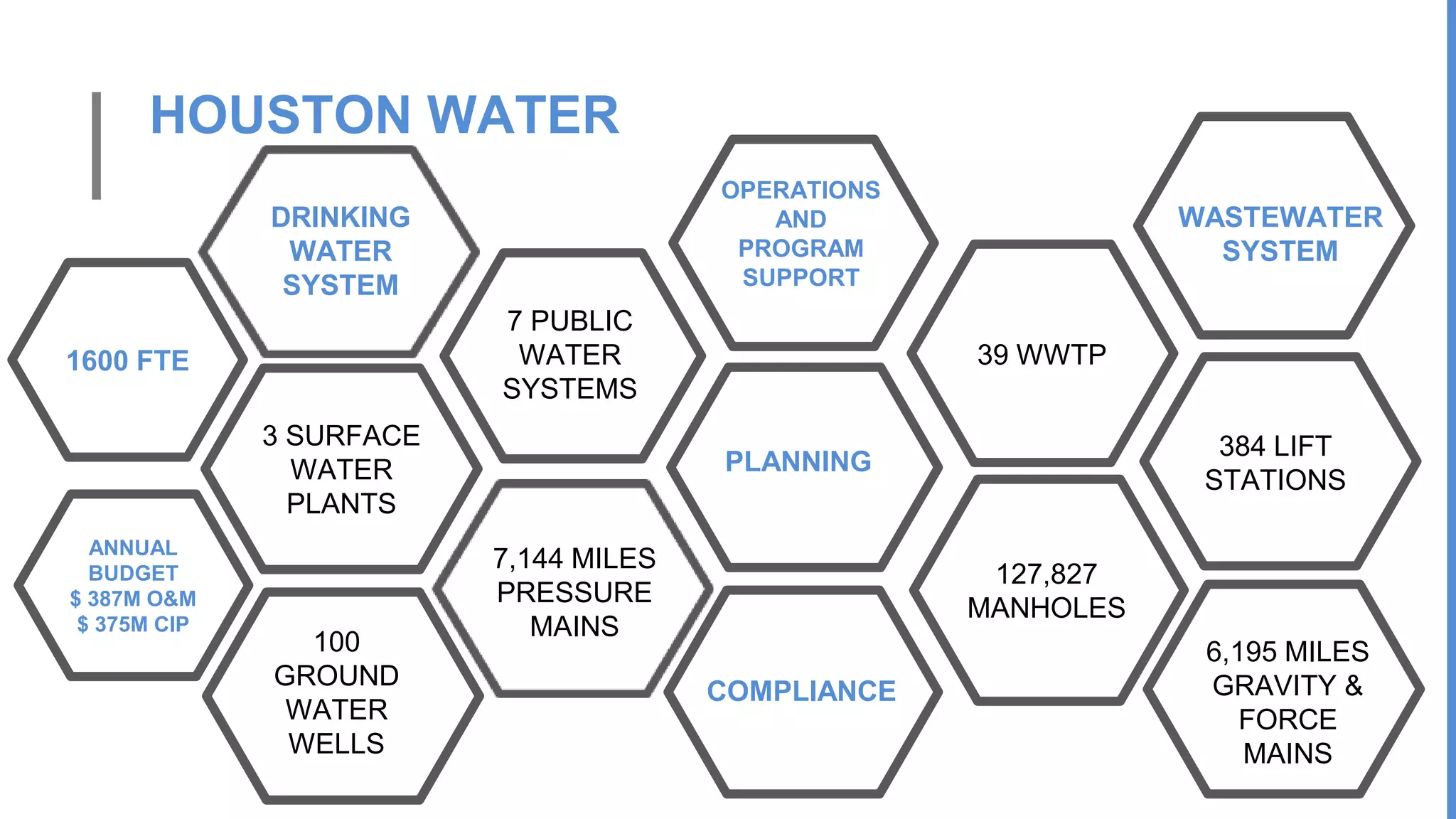
The city of Grants, New Mexico hired a water consultant to study reports claiming the city was responsible for flooding near Mt. Taylor Addition. The consultant's report found the city's sewer plant and golf course were not the cause of the flooding and that water seepage levels were normal. It noted localized drainage problems but found the water quality at the city facility was better than at Mt. Taylor Addition. The report made recommendations to further reduce seepage and monitor wells, but concluded the city was not responsible for the flooding issues reported.
The document discusses issues related to water infrastructure and management in cities. It notes that a significant portion of the global population lacks access to safe water and sanitation. It then focuses on Chicago's water infrastructure system, describing its history from the 1850s onwards, including the development of water supply tunnels, reservoirs, sewer systems and more recent projects like the Tunnel and Reservoir Plan to reduce combined sewer overflows. It discusses the challenges of managing stormwater and the impacts of climate change on water infrastructure systems.
This document discusses changing water levels in the Great Lakes. It begins with an introduction and outline. It then covers historical water levels, including their seasonal and interannual variation. The main drivers of water level changes are described as the hydrologic cycle of precipitation, evaporation, runoff and flows between lakes. Projections are discussed for both seasonal and decadal timescales. The conclusions discuss challenges around quantifying data value, using models to replace observations, uncertainty quantification and the ability of projections to offer insights rather than firm predictions.
This document discusses how recycling produced water from oil and gas production can help address Texas' growing water supply challenges. It notes that Texas' population and water demand are projected to increase substantially by 2060 while supplies are expected to decline. Recycling two-thirds of the roughly 7 billion barrels of produced water generated annually could meet 3.3% of the state's current water demand and 26% of the projected shortage in 2020, providing an unexpected solution to the state's water crisis through beneficial reuse of this resource.
Laura Fields-Sommers conducted a study assessing the effects of riverbank inducement on groundwater quality in a shallow aquifer in southeastern Wisconsin. She found that 1) cation exchange capacity in wells near the river was depleted, likely due to mixing of river water and groundwater, 2) river water was influenced by wastewater treatment plant effluent as shown through isotopic signatures, and 3) bacterial sequencing revealed genetic markers from human waste at some sampling sites, indicating sewage contamination of the river and groundwater.
The importance of groundwater surface water interaction - a case study on Rio...The Texas Network, LLC
Presented by Ronald T. Green, Ph.D., P.G., F. Paul Bertetti, P.G., and Marques Miller
at the Texas Water Conservation Association Conference in The Woodlands, Texas - March 2014
This document summarizes a presentation given in June 2016 about water resources in the Highland Lakes region of Texas. It discusses how rainfall and water inflows into Lakes Buchanan and Travis had reached record lows in recent years, but that 2015 saw extremely heavy rains and flooding that raised lake levels significantly. Current lake levels in 2016 remained higher than the beginning of the year due to continuing above average rainfall. The presentation covers the lakes' role as a shared water resource and flood management efforts.
The DPW provided an update on the water system to the Town Council at the meeting of Jan 30, 2019. The Council took steps later in the meeting to fund the multi-year water line replacement plan as outlined
The document summarizes a major flood event that occurred in Harris County, Texas on April 17-18, 2016 known as the Tax Day Flood. It provides details of the antecedent conditions including high rainfall in March 2016. It describes the activation timeline of warnings and emergency responses. Rainfall totals of up to 23.5 inches were observed with numerous high water rescues required. Flooding impacted numerous watersheds with record flood levels observed. Over 10,000 structures were preliminarily reported to have flooded including over 40,000 vehicles. Nine fatalities were associated with the flooding.
Presentation by Kathleen Jackson, director of the Texas Water Development Board, at the 2018 Gulf Coast Water Conservation Symposium in Houston, Texas.
1) The document discusses a study of water quality in urban runoff in the Springfield, Missouri metropolitan area from 2009-2014.
2) Thirty-three sampling sites within 6 municipalities were tested to characterize stormwater quality, reduce impacts on aquatic habitats, and establish Total Maximum Daily Loads.
3) The results found that 73.4% of samples exceeded the TMDL for total nitrogen and 81.3% exceeded it for total phosphorus, but no clear trends were observed related to percent urban area or drainage area.
TWCA Annual Convention: Water Rights Developments in Other States, Lyn ClancyTWCA
This document summarizes several recent court cases related to water law and policy in various western states:
- In California, a court found that the public trust doctrine can protect groundwater connected to navigable waterways from overextraction. Another case supported regulating water use to protect salmon runs.
- Oregon law requires considering impacts to specific fish species when approving new municipal water permits or extensions.
- Washington courts found that new diversions cannot impair existing instream flows without overriding public interest, and that injury to senior water rights is not permitted even for municipalities.
- In Colorado, private diversions for recreational or aesthetic purposes were not considered a beneficial use of water under the prior appropriation system.
TWCA Annual Convention: Can/Should Texas Learn from Colorado? Jordan Furnans ...TWCA
This document summarizes information presented about groundwater-surface water interactions and regulation methods in Colorado and Texas. It discusses a 2012 investigation by the TCEQ into missing water from the San Saba River in Texas that was concluded to be caused by shallow groundwater irrigation wells pumping surface water. It then provides an overview of Colorado's evolving water administration system and legislation recognizing the connection between groundwater and surface water. Finally, it briefly describes field methods for studying surface water-groundwater interactions using fluorescence fingerprinting and modeling groundwater pumping impacts to surface water.
This document contains information about stream monitoring and assessment in the Middle Eel River watershed in Indiana. It includes maps showing the locations of impaired streams and watershed management plans. Tables present biological monitoring data for sites, including the Index of Biotic Integrity (IBI) and Qualitative Habitat Evaluation Index (QHEI) scores. Metrics used to calculate these indices are also listed. Photos show biological sampling and stream habitat assessment.
Providing safe, clean water for Santa Clara CountyLaura Rinaldi
The document summarizes the work of the Santa Clara Valley Water District to provide safe and clean water for Santa Clara County. It discusses the district's historical development, its integrated approach to water supply, flood protection and stream stewardship. It also provides facts about the district's infrastructure, efforts to protect groundwater, champion conservation and prepare for future challenges around climate change and sea level rise.
The document analyzes the effect of fertilization and environmental factors on water quality in the Upper Cove River Watershed. It tests variables like nitrate, temperature, dissolved oxygen, pH, and conductivity at various sites over time. The hypothesis is that nitrate levels will be higher in the east tributary flowing from a golf course and water quality will improve after passing through marsh areas. Testing found nitrate was higher in the east tributary and decreased after wetlands, while dissolved oxygen was higher in the west tributary. pH was lowest in late October and highest in early January.
The document analyzes the effect of fertilization and environmental factors on water quality in the Upper Cove River Watershed. It tests variables like nitrate, temperature, dissolved oxygen, pH, and conductivity at various sites over time. The hypothesis is that nitrate levels will be higher in the east tributary flowing from a golf course and water quality will improve after passing through marsh areas. Testing found nitrate was higher in the east tributary and decreased after wetlands, while dissolved oxygen was higher in the west tributary. pH varied over time while conductivity and other factors were analyzed.
This document discusses methods for measuring water resources, including the hydrological cycle. It introduces traditional methods like gauging stations and SNOTEL stations to measure streamflow and snowpack. It also introduces geodetic methods using GPS and gravity satellites to measure aspects of the hydrological cycle like groundwater and snow levels. Trend data is presented showing declines in snowpack and streamflow in Montana watersheds like Willow Creek over recent decades likely due to climate change impacts.
This document summarizes the services provided by a water and sewage company that serves 27 million clients across 363 cities. It discusses the company's water treatment stations, sewage collection networks, investments made to improve water quality in rivers, and its goals to provide universal sanitation services and water supply across the state.
Groundwater levels are declining in Chittagong, Bangladesh due to increasing population, urbanization and groundwater extraction. A study analyzed groundwater level data from 2009-2013 in 35 wells across Chittagong. It found that the average groundwater level rose from 43.83m in 2009 to 56.74m in 2013, with declines of 0.122-7.922 m/year in individual wells. A spatial map showed variation in groundwater levels across the city. The study recommends regular monitoring, limiting extraction during dry periods, and using alternative pumps where over-abstracted to manage groundwater sustainably.
This document provides an analysis of the Platte River watershed located in Grant County, Wisconsin. It describes the watershed characteristics including land use, soils, precipitation trends, and stream geomorphology. Two sediment models are developed using factors like slope, soils, land use, and distance to streams to identify areas of high, medium, and low sediment runoff potential. The models are then compared to phosphorus export coefficients from another model called PRESTO to evaluate similarities between areas identified as high or low risk. The analysis finds the second sediment model more accurately identifies a small portion of the watershed as high risk, while the models show similarities for areas identified as low risk.
The document summarizes a study analyzing the adoption of green stormwater infrastructure (GSI) in Tucson, Arizona over the last decade. The key findings are:
1) On average, Tucson sub-watersheds have a GSI adoption rate of 4.7% of treated acreage and 5.8% of treated parcels, indicating room for further implementation.
2) The watersheds with the highest GSI treatment tend to be smaller and closer to urban areas, likely due to higher resident interest and more advocacy.
3) Certain watersheds have met or are approaching a goal of 10-25% GSI adoption, which modeling suggests could significantly reduce stormwater flooding and pollution.
The West Gulf River Forecast Center provides hydrologic forecasts for a diverse region covering parts of Texas, Oklahoma, Arkansas and Louisiana. They use precipitation estimates from multiple sensors, hydrologic models, and expert judgment to issue river forecasts. Their focus has expanded beyond routine forecasts to include impact-driven services like custom graphics and briefings to better inform emergency managers and the public. Future improvements include higher resolution modeling and expanded flood inundation mapping to provide more localized streamflow information.
This document summarizes a study looking at nitrogen impacts from cranberry agriculture in the Buzzards Bay watershed. It notes that cranberry is the dominant form of agriculture in the area and aims to better understand nitrogen contributions from cranberry bogs. The study will examine two common types of bog configurations over 14 months, measuring nitrogen and phosphorus concentrations before and after water passes through the bogs. The goal is to calculate nitrogen mass leaving the bogs and help reduce uncertainty around nitrogen loading from cranberry agriculture.
The History, Science & Economics of Bringing Back Comanche Springs, Robert Ma...TWCA
This document discusses strategies for restoring flow to Comanche Springs in Fort Stockton, Texas. It analyzes the relationship between pumping in Management Zone 1 of the Middle Pecos Groundwater Conservation District and spring flow. Reducing pumping by methods like permit retirement, irrigation efficiency, and crop switching could help bring the springs back. Funding may come from sources like the US Bureau of Reclamation, Texas Water Development Board, or bond issuances supported by new revenues from tourism drawn to restored spring flow. Full restoration may require reducing pumping by around 50,000 acre-feet per year.
The document summarizes the Louisville MSD infrastructure including its combined sewer system history and efforts to reduce combined sewer overflows through green infrastructure initiatives. It notes that the combined sewer system covers 24,000 acres and 670 miles of pipe, discharging over 2.6 billion gallons of overflow annually. Louisville MSD has invested over $400 million in a program to achieve 95% wet weather capture and comply with regulatory requirements through projects like dam installations, storage basins, and an amended consent decree requiring further improvements. The presentation highlights Louisville MSD's focus on green infrastructure strategies like rain gardens, bioswales, downspout disconnections, and green alleys to further reduce overflows in a cost-effective manner
Mission Bhagiratha aims to provide safe drinking water to every rural household in Telangana by 2019. It will source water from major rivers and reservoirs, treat it in water treatment plants, and distribute through a pipeline network of over 1,46,000 km to 68.46 lakh households. The project will develop infrastructure like intake structures, water treatment plants, reservoirs, and a transmission network to deliver 100 litres per capita per day (lpcd) of drinking water. It aims to improve public health and reduce water-borne diseases in the state.
This document summarizes the design and evaluation of a stormwater pollution abatement facility for Hickey Run in the U.S. National Arboretum. It describes the highly urbanized watershed draining to Hickey Run, which is impaired for floatables and oil/grease. Six candidate stormwater treatment systems were evaluated based on data from verification programs. A treatment train of two hydrodynamic separators was selected to remove 51-80% of particles to address the TMDL for trash in the Anacostia River. The facility is designed to treat the first 0.5 inches of rainfall and has provisions for bypass of high flows.
Retrospective analysis of hydrologic impacts in the Chesapeake Bay watershedHarsh Beria
This document summarizes the results of using the Hydrologic Simulation Program FORTRAN (HSPF) model to simulate hydrologic impacts in the Chesapeake Bay watershed over 22 years. The model performed reasonably well at larger time scales but tended to overestimate peak flows and underestimate low flows. Statistical analysis found increasing streamflow trends correlated with increasing precipitation and land use changes. Peak flows were typically preceded by low flow years and high median flow years showed greater flow variability.
This document discusses the conservation and management of water resources in rural areas through smart monitoring systems. It covers topics such as the global distribution of water, water quality assessment, treatment methods like chlorination, and the implementation of gravity-fed water systems. The key points are that smart water monitoring using mobile technologies can help address water security challenges in rural India. It also emphasizes the need to provide adequate and safe drinking water to all rural areas through technical, financial, and institutional innovations in water resources management.
The document summarizes a public presentation on Typhoon Ondoy (Ketsana) and the Marikina River flood of September 26, 2009. It includes information on rainfall intensity and flood frequency statistics for the Marikina River Basin. It also discusses hydrologic modeling of the basin that was conducted, which estimated a peak flood discharge of 5770 cubic meters per second for the 2009 event, exceeding the previous 100-year flood level.
The document summarizes several extreme hydrologic events that occurred in the Philippines from 1990 to 2009, including floods, landslides, earthquakes, and volcanic eruptions. It analyzes rainfall data and flood impacts for major events like the 2004 Central Luzon flood. It recommends developing an inundation model to better understand flooding in Central Luzon river basins and help with flood mitigation planning.
The document summarizes the water supply outlook for Sammamish Plateau Water and Sewer District for the summer of 2015. It states that despite a statewide drought declaration, the district anticipates having an adequate water supply for the summer. Nearly 80% of the district's water comes from groundwater aquifers that are at normal levels for the season. The remaining 20% comes from regional surface supplies that are also in good shape. Conservation efforts by customers will still be important to manage supply.
Investigating Flooding Pattern Using Hydrologic Engineering Center-River Anal...Niraj Lamichhane
This study analyzed ice jams and flooding in the Grand River watershed in northern Ohio using the HEC-RAS hydraulic model. The objectives were to understand how ice jams contribute to flooding and create flood maps of different return periods. Field data and aerial imagery were used to develop the HEC-RAS model. The model showed that a 500-year flood would inundate homes, bridges and parks. Historical data analysis found that ice jams were most common during neutral ENSO phases. Increased winter temperatures may exacerbate ice jam flooding by accelerating snow and ice melt. The results can help identify at-risk areas and improve flood warning systems.
WATER RESOURCE SUSTAINABILITY OF THE PALOUSE REGION: A SYSTEMS APPROACHRamesh Dhungel
This thesis examines the sustainability of water resources in the Palouse Region located on the border of Idaho and Washington. The region relies on two confined groundwater aquifers, the upper Wanapum and lower Grande Ronde, which show declining water levels. The author develops system dynamics models to simulate population growth, water demand, hydrological processes, and economic factors. The simple model lumps the aquifers together, while the hydraulically separated model divides them based on geology. Water balance calculations estimate recharge rates. Regression analysis determines the price elasticity of water demand. The models project the lifespan of the aquifers under different recharge and demand scenarios. Assuming potential surface water use and a water management strategy,
Austin Water is engaged in aggressive water conservation and climate programs aimed at reducing water use and addressing the water-energy nexus, while continuing to provide reliable and sustainable water and wastewater service to customers. The programs include: mandatory watering restrictions; installation of renewable energy at plants and facilities; and implementing employee ideas to save energy in operations – all while dealing with the worst drought since the historic drought of the 1950s.
Briefing lta to key leaders on drought and lake elevation safeguards v3 2014LakeTexoma
The Lake Texoma Association is celebrating over 50 years of promoting and protecting Lake Texoma in Oklahoma and Texas. Lake Texoma generates over $600 million per year in economic benefits from tourism and recreation for the region. However, ongoing drought since 2011 has rapidly lowered water levels, threatening the regional economy by reducing business revenue and jobs. Amendments are requested to drought management plans and legislation to better protect lake levels and the regional economy during drought conditions.
The document provides updates on the status of various water authority facilities and projects, including the completion of pipeline and plant upgrades. It discusses surface water costs and usage over time. It also outlines financial information, conservation efforts, and drought conditions in Texas with decreasing lake and reservoir levels. The water authority rates are expected to continue increasing to fund required projects to meet future water demands.
Similar to Houston Water Future & Water Conservation’s Role (20)
Martha Wright and Sasha Kodet from the San Antonio Water System discuss using data to drive customer engagement for the 2020 Central Texas Water Conservation Symposium hosted by the Texas Living Waters Project.
Collins Balcombe from the US Bureau of Reclamation discusses the new WIIN Act for the 2020 Central Texas Water Conservation Symposium hosted by the Texas Living Waters Project.
Andrew Spurgin, Principal Planner for the City of Westminster, Colorado, discusses integrating water and land use for the 2020 Central Texas Water Conservation Symposium hosted by the Texas Living Waters Project.
Dan Pedersen, Reclaimed Water Program Manager from the City of Austin, discusses the future of Austin Water's reclaimed water system for the 2020 Central Texas Water Conservation Symposium hosted by the Texas Living Waters Project.
David Turnage from Austin Water discusses residential irrigation evaluations for the 2020 Central Texas Water Conservation Symposium hosted by the Texas Living Waters Project.
Bill Cesanek, co-chair of the APA Water and Planning Network, discusses the value of land use planning in achieving improved water efficiency for the 2020 Central Texas Water Conservation Symposium hosted by the Texas Living Waters Project.
Mark Warden, Utility Conservation Coordinator for the city of Georgetown, discusses maximizing the value of irrigation evaluations for the 2020 Central Texas Water Conservation Symposium hosted by the Texas Living Waters Project.
David Switzer from the University of Missouri discusses affordability, conservation, and water rate setting for the 2020 Central Texas Water Conservation Symposium hosted by the Texas Living Waters Project.
This webinar is a primer on how to get involved in key Houston-area flood-mitigation efforts. It provides an overview of the funding involved, methods of public commenting, and an introduction to current concerns in area communities most vulnerable to flooding.
Watch the webinar at: https://texaslivingwaters.org/deeper-dive/a-seat-at-the-table-how-to-engage-in-houston-area-flood-mitigation/
Speakers include:
Dr. Earthea Nance, Associate Professor, Texas Southern University
Danielle Goshen, Water Policy & Outreach Specialist, Galveston Bay Foundation
Amy Reed, Staff Attorney, Environmental Law Institute
Stephanie Oehler, Public Interest Law Fellow, Environmental Law Institute
Jordan Macha, Executive Director, Bayou City Waterkeeper
Amanda Fuller, Director, Texas Coast & Water Program, National Wildlife Federation
The workshop is the first of an intended series of conversations on how area residents can better participate in key processes that will shape their neighborhoods' futures. If you'd like more information on future events contact us at info@texaslivingwaters.org.
This event was hosted online on Aug 5, 2020 by the National Wildlife Federation, Sierra Club (Lone Star Chapter), Bayou City Waterkeeper, and Galveston Bay Foundation.
This webinar provides an in-depth introduction to the 2020 Texas Water Conservation Scorecard. The only effort of its kind in Texas, the Scorecard offers an extraordinarily detailed analysis of water conservation efforts at over 350 Texas water utilities. Jennifer Walker, Deputy Director of the Texas Coast and Water Program at the National Wildlife Federation leads the webinar, along with Ken Kramer, Water Resources Chair at the Lone Star Chapter of the Sierra, and Meghan Bock, Senior Business Analyst at AIQUEOUS.
An initiative of the Texas Living Waters Project, the Scorecard evaluates each utility on a range of criteria including compliance with conservation planning and reporting requirements, its record on water loss and meeting targets for water use reduction, outdoor watering limits, and rate-based incentives for efficient use of water.
Taken in conjunction with the 2016 report, the 2020 Scorecard reveals many utilities are not taking serious actions to advance water conservation.
For more information on the Scorecard’s methodology, results, and recommendations, take a look at the Scorecard website at texaswaterconservationscorecard.org. The interactive site allows users to quickly identify individual utilities’ scores and analysis.
Presentation by Ryan Kelso, Director of Water Services and Compliance for New Braunfels Utilities, for the 2019 Gulf Coast Water Conservation in Houston, Texas.
Presentation by Bill Christiansen, Director of Programs for the Alliance for Water Efficiency, for the 2019 Gulf Coast Water Conservation in Houston, Texas.
Presentation by John Sutton of the Texas Water Development Board's Municipal Water Conservation Program for the 2019 Gulf Coast Water Conservation in Houston, Texas.
Presentation by Veronica Blette, Chief of the EPA Office of Wastewater Management's WaterSense Program, for the 2019 Gulf Coast Water Conservation in Houston, Texas.
Presentation by Mary Ann Dickinson, president and CEO of the Alliance for Water Efficiency, for the 2019 Central Texas Water Conservation Symposium in Austin, Texas.
The document summarizes Austin's Water Forward plan to ensure reliable water supply for the growing population. It discusses Austin's current water sources, the historic drought, and recommends a hybrid portfolio approach. This includes maximizing conservation, local sources, and reliability through strategies like aquifer storage/recovery, brackish desalination, reuse expansion, and indirect potable reuse. The plan estimates costs and yields through 2040 and outlines next steps like developing codes/incentives and starting an aquifer storage pilot.
This document summarizes the requirements for developing a water conservation plan in Texas. Municipalities serving 3,300 connections or more, with financial obligations over $500k to the Texas Water Development Board, or with surface water rights from the Texas Commission on Environmental Quality must submit a plan. Plans must be revised every five years and include goals for reducing total, residential, and water loss gallons per capita per day. Details on leak detection programs, non-promotional water rates, conservation best practices, and annual reporting are required. Resources from the Texas Water Development Board like online reporting tools and training are available to help utilities develop effective water conservation plans.
The document discusses new and updated best practices for water conservation planning. It highlights the importance of developing five-year conservation plans and customizing practices to the specific needs and patterns of individual communities. Communities are encouraged to analyze customer water usage data to prioritize effective best management practices such as assistance programs for economically disadvantaged customers, outdoor watering schedules, enforcement of irrigation standards, and custom conservation rebates for industrial and commercial users. Developing a plan that thoroughly discusses strategy, selected practices, and evaluation can receive gold star recognition.
The modification of an existing product or the formulation of a new product to fill a newly identified market niche or customer need are both examples of product development. This study generally developed and conducted the formulation of aramang baked products enriched with malunggay conducted by the researchers. Specifically, it answered the acceptability level in terms of taste, texture, flavor, odor, and color also the overall acceptability of enriched aramang baked products. The study used the frequency distribution for evaluators to determine the acceptability of enriched aramang baked products enriched with malunggay. As per sensory evaluation conducted by the researchers, it was proven that aramang baked products enriched with malunggay was acceptable in terms of Odor, Taste, Flavor, Color, and Texture. Based on the results of sensory evaluation of enriched aramang baked products proven that three (3) treatments were all highly acceptable in terms of variable Odor, Taste, Flavor, Color and Textures conducted by the researchers.
A Comprehensive Guide on Cable Location Services Detections Method, Tools, an...Aussie Hydro-Vac Services
Explore Aussie Hydrovac's comprehensive cable location services, employing advanced tools like ground-penetrating radar and robotic CCTV crawlers for precise detection. Also offering aerial surveying solutions. Contact for reliable service in Australia.
Monitor indicators of genetic diversity from space using Earth Observation dataSpatial Genetics
Genetic diversity within and among populations is essential for species persistence. While targets and indicators for genetic diversity are captured in the Kunming-Montreal Global Biodiversity Framework, assessing genetic diversity across many species at national and regional scales remains challenging. Parties to the Convention on Biological Diversity (CBD) need accessible tools for reliable and efficient monitoring at relevant scales. Here, we describe how Earth Observation satellites (EO) make essential contributions to enable, accelerate, and improve genetic diversity monitoring and preservation. Specifically, we introduce a workflow integrating EO into existing genetic diversity monitoring strategies and present a set of examples where EO data is or can be integrated to improve assessment, monitoring, and conservation. We describe how available EO data can be integrated in innovative ways to support calculation of the genetic diversity indicators of the GBF monitoring framework and to inform management and monitoring decisions, especially in areas with limited research infrastructure or access. We also describe novel, integrative approaches to improve the indicators that can be implemented with the coming generation of EO data, and new capabilities that will provide unprecedented detail to characterize the changes to Earth’s surface and their implications for biodiversity, on a global scale.
Exploring low emissions development opportunities in food systemsCIFOR-ICRAF
Presented by Christopher Martius (CIFOR-ICRAF) at "Side event 60th sessions of the UNFCCC Subsidiary Bodies - Sustainable Bites: Innovating Low Emission Food Systems One Country at a Time" on 13 June 2024
Emerging Earth Observation methods for monitoring sustainable food productionCIFOR-ICRAF
Presented by Daniela Requena Suarez, Helmholtz GeoResearch Center Potsdam (GFZ) at "Side event 60th sessions of the UNFCCC Subsidiary Bodies - Sustainable Bites: Innovating Low Emission Food Systems One Country at a Time" on 13 June 2024
4. HOUSTON WATER
3 SURFACE
WATER
PLANTS
100
GROUND
WATER
WELLS
7,144 MILES
PRESSURE
MAINS
7 PUBLIC
WATER
SYSTEMS
PLANNING
39 WWTP
384 LIFT
STATIONS
6,195 MILES
GRAVITY &
FORCE
MAINS
127,827
MANHOLES
WASTEWATER
SYSTEM
DRINKING
WATER
SYSTEM
OPERATIONS
AND
PROGRAM
SUPPORT
COMPLIANCE
ANNUAL
BUDGET
$ 387M O&M
$ 375M CIP
1600 FTE
5. WEATHER EVENTS
• 2008 HURRICANE IKE – CAT 2, 110 MPH MAX SUSTAINED WINDS
• 2011 DROUGHT OF RECORD ~45 WEEKS, 95% OF TX IN DROUGHT
• 2015 MEMORIAL DAY FLOOD, 12” RAIN IN 10 HOURS
• 2016 TAX DAY FLOOD, 17” RAIN IN 14 HOURS
• 2016 MEMORIAL DAY FLOOD, BEGAN BUILDING AN ARK
• 2017 HURRICANE HARVEY, 36-48” RAIN IN HOUSTON METRO
6.
7. SINCE HARVEY
LEAK ON 102” RAW WATER LINE
LEAK ON 66” TREATED WATER LINE
LEAK ON 54” TREATED WATER LINE
LEAK ON 48’ TREATED WATER LINE
HUNDREDS OF LEAKS IN DISTRIBUTION SYSTEM
RAW WATER QUALITY HAS CHANGED
Hurricane Ike occurred in September 2008.
Preparations included having tiered staffing assignments. Response included legislation requiring generators at all water production facilities.
Drought of record stressed our water distribution and productions system. Beginning of focused asset management program.
May 27, 2015 event produced nearly 11 inches of rain and caused flash flooding. Began building flood wall and raising electronics as facilities near bayous.
April 18, 2016 almost 17 inches of rain caused additional flash flooding. Repairs from 2015 were not completed.
May 28, 2016 looking for an ark!
First you must know what is in your system and where it is at. Upload to the cloud and download to a flash drive. When receiving offers of assistance be as specific a possible about your needs.
Take care of your people first and foremost. They will take care of your customers..
Recovery takes time and you can’t go back to business as usual. Your system may not be configured the same when it is all said and done.