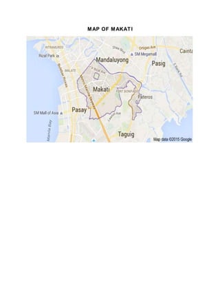
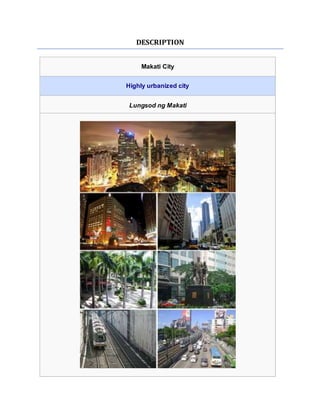
This document provides a map and description of Makati City, Philippines. It discusses Makati's history from its founding in the 1600s as a farming community up through its transformation into the financial and commercial capital of the Philippines starting in the late 1960s. Key details include Makati becoming the location of many multinational corporations and major banks, its population of over 500,000, and its Central Business District being the economic hub located along Ayala Avenue.
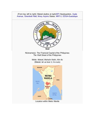
![Makati City
Location within the Philippines
Coordinates: 14°33′N 121°02′ECoordinates: 14°33′N 121°02′E
Country Philippines
Region National Capital
Districts 1st and 2nd districts of Makati City
Settled November 4, 1670
Cityhood January 2, 1995
Barangays 33
Government
• Type Mayor–council government
• Mayor Jejomar Binay, Jr..(UNA)
• Vice Mayor Romulo Pena Jr.(LP)
• Makati City Council Councilors[show]
Area[1]
• Total 21.57 km2 (8.33 sq mi)
Elevation 15.4 m (50.5 ft)
Population (2010)[2]
• Total 529,039
• Density 25,000/km2 (64,000/sq mi)
Time zone PST (UTC+8)](https://image.slidesharecdn.com/makati-150804111747-lva1-app6892/85/Makati-4-320.jpg)
![ZIP Code 1200 to 1299
Dialing code 02
Website www.makati.gov.ph
Makati (/məˈkɑːti/ mə-KAH-tee Tagalog pronunciation: [maˈkati]), officially the City of
Makati (Filipino: Lungsod ng Makati), in thePhilippines, is one of the sixteen cities that
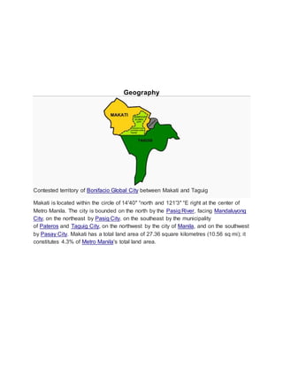
make up Metro Manila. Makati is located within the circle of 14′40″ °north and 121′3″ °E
right at the center of Metro Manila.
Makati is the financial center of the Philippines; it has the highest concentration of
multinational and local corporations in the country.[3] Major banks, corporations,
department stores as well as foreign embassies are based in Makati. The biggest
trading floor of the Philippine Stock Exchange is situated along the city's Ayala
Avenue.[4][5] Makati is also known for being a major cultural and entertainment hub
in Metro Manila.[6]
With a population of 529,039 Makati is the 16th-largest city in the country and ranked as
the 41st most densely populated city in the world with 19,336 inhabitants per square
kilometer. Although its population is just half a million, the daytime population of the city
is estimated to be more than one million during a typical working day because of the
large number of people who go to the city to work, shop, and do business.](https://image.slidesharecdn.com/makati-150804111747-lva1-app6892/85/Makati-5-320.jpg)
![History
Parts of the city were once subject to the pre-Hispanic Kingdom of Namayan, whose
capital is now in the Santa Ana district ofManila. The Spanish then assigned the area to
the town of Santa Ana de Sapa and in the 1600s[9] began to be developed as a
pilgrimage center around the churches of Our Lady of Guadalupe (now Our Lady of
Grace) and of Saints Peter and Paul in what is today the población, built by missionary
friars to attract worshippers, and also as a farming community. It became an
independent municipality in 1670, and was christened San Pedro de Macati in honour of
the town's patron, Saint Peter. The town was also famous for its pottery industry since
the 18th century, with skilled potters trained by Jesuit priests.[citation needed] Its strategic
location also made it a pitstop for pilgrims, travelling by foot or boat, towards the shrine
of Our Lady of Peace and Good Voyage in Antipolo.
In 1851, Don José Bonifacio Roxas (an ancestor of the Zobel de Ayala family)
purchased the Jesuit estate of "Hacienda San Pedro de Macati" for 52,800
pesos.[10] Since then, the development of Makati has remained linked with the Zóbel de
Ayala familyand their company, Ayala Corporation.[11]
The town was a cradle of Filipino passive resistance against Spanish colonial rule in the
1890s and the subsequent Philippine Revolution, with the participation of the
local Katipunan council based in the area with Pio del Pilar, a local resident from the
village of Culi-Culi, as its president.[citation needed] Culi-Culi is now a barangay named in
honour of Del Pilar.](https://image.slidesharecdn.com/makati-150804111747-lva1-app6892/85/Makati-7-320.jpg)
![American period
By 1898, Spain ceded the Philippines and other overseas possessions to the United
States after the former's defeat in theSpanish–American War. In 1901, the Americans
declared the whole area south of the Pasig River, including the town of San Pedro de
Macati, down to Barangay Ayala Alabang in Muntinlupa, a US military reservation, thus
establishing Fort McKinley (nowFort Bonifacio). That same year, the whole town, with a
population of 25,000, was incorporated from Manila to the new province of Rizal, with
Marcelino Magsaysay serving as the town president.[citation needed] As the 1910s
approached the Meralco tranvia lines to Fort McKinley and to the western end of the
town were built, opening transport lines for its residents and thus brought along potential
investors who opened several businesses including the famous Santa Ana Cabaret at
the terminus of the streetcar lines.
In February 28, 1914, the The Philippine Legislature passed Act 2390, shortening the
name, San Pedro de Macati, to simply Makati. In the 1930s, the first airport
in Luzon island, Nielsen Field, opened in what is now the Ayala Triangle, and the tracks
of what is now the Philippine National Railways reached the town very early in the
decade. During that same period, Santa Ana Park, the nation's second horse racing
facility, opened to expectations from horse racing fans.](https://image.slidesharecdn.com/makati-150804111747-lva1-app6892/85/Makati-8-320.jpg)
![Post-war
Makati skyline with the Manila Golf Club on the foreground.
After the destruction Second World War had brought upon Makati, the town grew
rapidly, and real estate values boomed. The first of the planned communities (in what
are now the barangays Forbes Park, Urdaneta, San Lorenzo and Bel-Air) were
established in the 1950s with the efforts of its landowner, Ayala y Compañía, and at the
same time, Fort McKinley, then renamed Fort Bonifacio and the then Philippine
Army headquarters, became the starting point for the building up of seven more
communities this time by military families who worked in the base area, while the first
office buildings began to be built on what is now the central business district. Since the
late 1960s, Makati has transformed into the financial and commercial capital of the
country.[9]
During the terms of town mayors Máximo Estrella, Rafael Bañola, José Luciano, Cézar
Alzona and Nemesio Yabut, massive development of the town took place, and foreign
and local investors were welcomed to what was tagged as the nation's number one
municipality at the time. Makati's central location also made it an industrial hub for major
national and international corporations. Partly as a result a new town hall just miles from
the old one was built in 1962 just along J.P. Rizal Street (the old hall was later
converted into the city museum). Mayor Bañola's term of office as town executive saw
the building up of what is now the Ayala Center with the help of the Ayala firm, which
would become the city's central shopping center of today.
In 1975, Makati was separated from Rizal province along
with Caloocan, Malabon, Navotas, Quezon City, Marikina, San
Juan, Pasig, Mandaluyong, Pateros, Taguig, Pasay City,Parañaque, Las Piñas,
and Muntinlupa, to become part of the National Capital Region as a component city.](https://image.slidesharecdn.com/makati-150804111747-lva1-app6892/85/Makati-9-320.jpg)
![Following the assassination of opposition senator Benigno Aquino, Jr. on 21 August
1983, Makati became a nexus for protests against the dictatorship
of President Ferdinand E. Marcos. Known as the Confetti Revolution, the
demonstrations held in the central business district were led partly by employees of
major corporations based in the area, culminating in the 1986 People Power
Revolution that toppled Marcos’ 20-year authoritarian regime. His political rival and
successor, Corazon C. Aquino–the wife of the deceased senator Aquino–became the
eleventh and first female president of the Philippines. After the death of Mayor Yabut
during the Revolution, Aquino appointed Jejomar Binay as acting mayor of the town of
Makati; he was subsequently elected as mayor in 1987. His first term as the town
executive would see the events of a 1989 coup d'etat attempt in the town's business
district, and would help usher the building of the country's first skyscrapers in the early
1990s.
On May 17, 2000 at 5:02 p.m., the Glorietta Mall located inside the Ayala Center was
bombed, injuring 13 persons. According to local authorities, the homemade bomb
originated from a restroom of a restaurant a video arcade. The bombing was said to be
the precursor of the May 21, 2000 SM Megamall bombing and the Rizal Day
bombings.[12] On October 19, 2007, an explosion in Glorietta 2 left eleven people dead
and injured more than a hundred. Initially, authorities said that it was caused by
a liquefied petroleum gasexplosion at a restaurant, but later began investigating the
possibility that the explosion may have been a C-4 bomb.](https://image.slidesharecdn.com/makati-150804111747-lva1-app6892/85/Makati-10-320.jpg)

![2000 471,379 −0.57%
2007 510,383 +1.10%
2010 529,039 +1.32%
Makati has a population of 529,039 as of the 2010 census.[2] Makati ranks ninth
in population size within Metro Manila municipalities. 88.9% of Makati residents
identified their religious affiliation as Roman Catholic.[citation needed] Other groups having
large number of members in the city are The Church of Jesus Christ of Latter-day
Saints, Ang Dating Daan, Iglesia ni Cristo, Protestantism, Islam, Hinduism, Buddhism
and Judaism.
Based on the City’s Transport and Traffic Improvement Plan 2004-2014, the
city’s daytime population is estimated to be 3.7 million during weekdays, owing to the
large number of people who come to work, do business, or shop.[17]
The daily influx of people into the city provides the skilled labor force that allows
Makati to handle the service requirements of domestic as well as international
transactions; it also serves as the base of a large consumer market that fuels the retail
and service trade in the city.[17] At the same time, however, the large tidal population
flows exert pressure on Makati's environment, services, and utilities, most noticeably
causing large traffic volumes along the major road corridors leading to the city as well
as within and at the periphery of the central business district.](https://image.slidesharecdn.com/makati-150804111747-lva1-app6892/85/Makati-14-320.jpg)
![Economy and infrastructure
Skyline of the Makati Central Business District
The city of Makati remains the richest local government unit (LGU) in the Philippines in
terms of income from local sources and on a per capita basis.[18] As of end-2012, Makati
had registered over 62,000 business enterprises, which are engaged in financial
services, wholesale/retail, services, real estate, export/import, and manufacturing.
Makati also boasts of having the highest number of BPO offices in Metro Manila at](https://image.slidesharecdn.com/makati-150804111747-lva1-app6892/85/Makati-15-320.jpg)
![1,159 companies to date, as well as the highest number of PEZA-accredited IT Parks
and Buildings. The city government of Makati has not increased its tax rates since its
new Revenue Code took effect in 2006. For 26 years now, the city enjoys a deficit-free
status.[18]
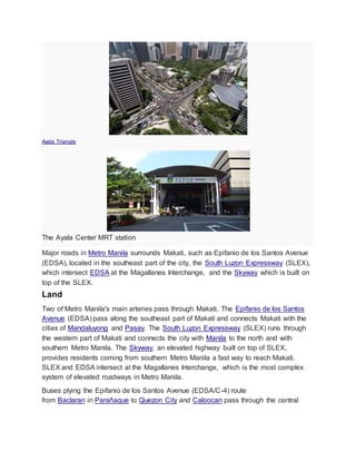
Ayala Avenue, dubbed as the Wall Street of the Philippines
The city is known for its developed business district called the Makati Central Business
District. It is bound by EDSA, Gil Puyat Avenue,Arnaiz Avenue/Pasay Road, and Chino
Roces Avenue. It mainly encompasses Legazpi Village, Salcedo Village, the Ayala
Center, and parts of Bel-Air Village.
The Ayala Triangle is a sub-district of the Makati central business district, comprising
the parcel of land between Ayala Avenue, Makati Avenue and Paseo de Roxas, as well
as the buildings on those streets. Many multinational companies, banks and other major
businesses are located within the triangle. A few upscale boutiques, restaurants and a
park called Ayala Triangle Gardens are also located in the area.[19] Ayala Avenue and
Paseo de Roxas also house the distinction of being the runways of the former Nielson
Field, Metro Manila's main airport in the 1930s.
Aerial photo of Makati CBD along Ayala Avenue](https://image.slidesharecdn.com/makati-150804111747-lva1-app6892/85/Makati-16-320.jpg)
![The biggest trading floor of the Philippine Stock Exchange is housed in Ayala Tower
One and at the old Makati Stock Exchange Building, both along Ayala Avenue.
The Makati Business Club is composed of over 800 chief executive officers and senior
executives representing almost 450 of the largest and most dynamic corporations in the
Philippines.[citation needed]
Most of the tallest skyscrapers in the Philippines are located in Makati such as
the Gramercy Residences, PBCom Tower and G.T. International Tower. Many high-rise
condominiums in Makati are developed or owned by renowned real estate companies in
the Philippines like Century Properties and Ayala Land.
PBCom Tower along Ayala Avenue is the country's tallest building, reaching up 259
meters. It is the headquarters of the Philippine Bank of Communications, or PBCom.
The PBCom Tower is an office skyscraper ranked officially as the tallest building in the
Philippines from 2000 until the topping-out of The Gramercy Residences in Makati
Poblacion in 2012. It has a total ground to architectural top height of 259 meters (850 ft),
with 52 stories[20] including an 8-level radio tower.
Shopping centers
Facade of the Greenbelt Mall
Makati City is one of the most well-known shopping hub of Metro Manila. Various
shopping centers, offering both international and local retail shops, high-end boutiques,
dining outlets and entertainment facilities can be found around the city.[21]](https://image.slidesharecdn.com/makati-150804111747-lva1-app6892/85/Makati-17-320.jpg)
![The Ayala Center is a major commercial development operated by Ayala Land, it is
located at the central business district of Makati, the center is known for its wide array of
shopping, entertainment and cultural offerings, making it a premier shopping and
cultural district in the metropolis.[22] It is a vast walkable complex with high-end malls
that houses cinemas, local and international shops, homegrown restaurants and
international food chains. The shopping malls that are located at the Ayala
Center includes Greenbelt, Glorietta, Park Square, and The Link. The Ayala Center is
also home to 3 department stores which include SM Makati, Rustan's, The Landmark.
and proposed of Robinsons Place Laperal Slum SM DreamSide City
Aside from the Ayala Center, the Rockwell Center is also a popular shopping district in
Makati, it is home to the Power Plant Mall. The Salcedo Saturday Market and Legazpi
Sunday Market are popular open-air community markets. These markets offers organic
products, specialty foods, fruits, vegetables, fish, gourmet items and antiques.
Education
The University of Makati, a public, non-profit university, is the city's flagship university.
Other institutions of higher education include the Asian Institute of Management (AIM),
the Ateneo Professional Schools, Australian Catholic University - Manila Program,
the Mapúa Institute of Technology, Lyceum of the Philippines University-Makati, Centro
Escolar University Makati, Far Eastern University- Makati, iAcademy, Asian Seminary of
Christian Ministries (ASCM), Don Bosco Technical Institute, Makati, Assumption
College San Lorenzo, Colegio San Agustin, Saint Paul College of Makati, Our Lady of
Guadalupe Minor Seminary, Asia Pacific College, Colegio De Sta. Rosa
Makati Assumption College among others.
Historical sites
Hagdang Bato
This part of Namayan was sacred to early Tagalogs. Hagdang bató (see photo) is
mentioned in chapter sixty-one of José Rizal's first novel, Noli Me Tángere, and chapter
three of his second novel, El Filibusterismo. During the Revolution on 10 June 1897,
Gen. Emilio Aguinaldo and about five hundred soldiers crossed the Pasig River at
Hagdang bató during the march to Biac-na-bató in Bulacán.
Museong Makati](https://image.slidesharecdn.com/makati-150804111747-lva1-app6892/85/Makati-18-320.jpg)
![Museo ng Makati
Located along J.P. Rizal St., the Museo ng Makati is housed in an old building, which
was built in 1918 and has been used as Makati's town hall from 1918 to 1961. The
museum keeps the records of Makati's history through a collection of rare photographs,
murals, and dioramas. It also contains artifacts, such as the fossils of pre-historic
animals and earthenware.[23]
The museum's architecture is a classic "Bahay na Bato", made of masonry at the
ground floor and wood at the upper level. In 1934, during the reign of Mayor Nicanor
Garcia, the structure was rebuilt using concrete materials. In 1958, while it was still used
as a town hall, then Mayor Maximo Estrella had it renovated. In 1961, when the local
government of Makati moved its office to its current site, the old town hall was used as
the Municipal Library.[citation needed]
But when the library was transferred to the new city hall compound, the old town hall
was used as the Philippine Eye and Ear Infirmary. During the term of Mayor Jejomar
Binay, the structure was converted into a museum through City Ordinance No. 186 that
was enacted in March 1990.
Nuestra Señorade Gracia Church](https://image.slidesharecdn.com/makati-150804111747-lva1-app6892/85/Makati-19-320.jpg)
![The Nuestra Señora de Gracia Church.
The Nuestra Señora de Gracia Church is a baroque Roman Catholic church which was
established in 1601 by Augustinian fathers.[25] Its original architecture is a blend of the
late Spanish Renaissance and early Baroque design. The touch of the Renaissance
period is found in the main entrance with rose window and simple Doric columns. The
interiors and the window details, meanwhile, have influences of Baroque architecture.
The floor plan, on the other hand, is Romanesque.[25] During the Seven Years' War, this
church was raided by the British, an event which marks the first time that Makati was
affected by a global conflict. The church was damaged due to an earthquake in 1880
and in 1898 during the early skirmishes between American and Filipino troops.[26]
The Nuestra Señora de Gracia Church is one of the most popular wedding venues
in Metro Manila.
Sts. Peter and PaulChurch
Tucked in D.M. Rivera St. and surrounded by skyscrapers and residential areas, Sts.
Peter and Paul Church is the oldest church in Makati, which was constructed in
1620.[29] It was built by Jesuit priest Rev. Pedro de los Montes at a site named
Buenavista through the generous donation of Capt. Pedro de Britto in 1607.[30]
The church's architectural design is a rectangular nave with apse and sacristy, which is
a usual design for colonial mission churches.[31] The façade is composed of three-tiered
papal and keys, symbols of the Papacy, which was first occupied by St. Peter, one of
the patron saints of the parish.](https://image.slidesharecdn.com/makati-150804111747-lva1-app6892/85/Makati-20-320.jpg)
![Culture and sports
The Ayala Museum
Makati is home to a number of fine art museums, colonial-era churches and recreation
areas.
Along the south-eastern border of Makati beyond Forbes Park are the Manila Golf
Club and the Manila Polo Club.[33] The Manila Golf Clubfeatures an 18-hole golf course.
The Manila Polo Club counts among its polo enthusiasts some of the country's
wealthiest people. The Makati Sports Club in Salcedo Village is another popular place
for sports. The Makati Coliseum is another famous sports landmark in the city, where
some of the biggest sports gatherings are held.
The Ayala Museum is a private fine arts and history museum housing various
exhibitions such as the "Gold of Ancestors," an exhibition of more than one thousand
golden pre-Hispanic artifacts.[34] Other popular museums also in Makati also include the
Yuchengco Museum and the Museo ng Makati.
Makati has several Spanish-era churches, such as the Our Lady of Guadalupe and
the Nuestra Señora de Gracia Church (Our Lady of Grace) in the old town. At the
Greenbelt Park stands the modern domed chapel of the Sto. Niño de la Paz.
Between Forbes Park andDasmariñas Village is the Santuario de San Antonio, a
popular church for weddings in the Makati area. The National Shrine of the Sacred
Heart is located in San Antonio Village. Makati also houses the country's only Jewish
synagogue, Beth Yaacov.
Future development](https://image.slidesharecdn.com/makati-150804111747-lva1-app6892/85/Makati-21-320.jpg)
![Ayala Land and the Makati Tourism Foundation launched a year-long campaign titled
"Make It Happen, Make it Makati" to increase Makati's visibility as an arts and culture
destination. The campaign is part of Ayala’s ongoing US$1.5 billion redevelopment
masterplan for Makati, which began in 2011 and divides the city into six distinct hubs for
business, lifestyle, entertainment and transport.[35]
In 2013, Ayala Land unveiled its plans for a P20-billion project that will transform the old
Sta. Ana race track into a mixed-use development, featuring entertainment and sports
facilities. It will sit on a 21-hectare property - the last available sprawling landbank in
Makati City and will be dubbed as "Circuit Makati" in honor of the Sta. Ana race track,
which is part of Makati's heritage as a former racing circuit. There will be a FIFA-sized
football turf which will be used for games and for football workshops. It will feature a 2-
hectare open-air events ground, which can accommodate up to 20,000 people. It will
have links to the Makati central business district (CBD) through Ayala Avenue Extension
and South Avenue, other future road linkages or potentially even a revived Pasig River
ferry service.
Transportation](https://image.slidesharecdn.com/makati-150804111747-lva1-app6892/85/Makati-22-320.jpg)
![business/financial district daily. Jeepneys ply Makati's inner roads and connect the city
to its surrounding towns and cities.
The country’s first-ever e-jeepney and hybrid bus services were piloted in Makati City.
The buses are parallel electric hybrids, powered by an electric motor and a Euro 3
diesel motor. The hybrid buses will ply the route from Buendia (Tramo/LRT-1 Taft)
to Kalayaan Avenue(C5), which are considered among the busiest in the city’s central
business district, cutting through other major roads like South Superhighway; Chino
Roces, Ayala and Makati Avenues; Paseo de Roxas and Edsa.[37]
Other major roads in Makati include Buendia Avenue, also called Sen. Gil Puyat
Avenue, which connects EDSA and SLEX in the north;Ayala Avenue, an important
street that runs through the central business/financial district; and Makati Avenue, which
connects Ayala Avenue with Buendia Avenue, also extending north to cross the Pasig
River to Mandaluyong City. At the center of Makati is the Ayala Triangle, a park built on
the former Nielsen Air Base.
Train
The Metro Rail Transit (MRT-3) on EDSA has four stations located in
Makati: Guadalupe, Buendia, Ayala and Magallanes.
The Philippine National Railways has three stations: Buendia, Pasay Road and EDSA.
In 2013, the National Economic and Development Authority (NEDA) worked on a
feasibility study for a $1.75 billion monorail project. The proposed 12.56-kilometer
elevated monorail is envisioned to connect Makati City, Bonifacio Global City, Pasay
City through the MRT Line 3 as well as the Ninoy Aquino International Airport. The
present alignment being considered starts from the MRT-3 (Guadalupe Station), enters
Bonifacio Global City through the north gate and ends at Ninoy Aquino International
Airport Terminal 3. If approved, the monorail project can be completed by 2016.[38]
Airport
The city is 20 minutes away from the Ninoy Aquino International Airport.
Water
The Pasig River is located north of Makati. The Pasig River Ferry Service has two
stations: Guadalupe and Valenzuel
Local government](https://image.slidesharecdn.com/makati-150804111747-lva1-app6892/85/Makati-24-320.jpg)

![Barangay
Population
(2004)
Population
(2010)[2]
Area
(km2)
District
Bangkal 22,433 23,378 0.74 1st
Bel-Air 9,330 18,280 1.71 1st
Carmona 3,699 3,096 0.34 1st
Cembo 25,815 27,998 0.22 2nd
Comembo 14,174 14,433 0.27 2nd
Dasmariñas 5,757 5,654 1.90 1st
East Rembo 23,902 26,433 0.44 2nd
Forbes Park 3,420 2,533 2.53 1st
Guadalupe
Nuevo
22,493 18,271 0.57 2nd
Guadalupe Viejo 13,632 16,411 0.62 2nd
Kasilawan 6,224 5,291 0.09 1st
La Paz 8,843 7,931 0.32 1st](https://image.slidesharecdn.com/makati-150804111747-lva1-app6892/85/Makati-26-320.jpg)
![Barangay
Population
(2004)
Population
(2010)[2]
Area
(km2)
District
Magallanes 7,509 5,576 1.20 1st
Olympia 20,172 21,270 0.44 1st
Palanan 16,614 17,283 0.65 1st
Pembo 35,035 44,803 1.23 2nd
Pinagkaisahan 6,186 5,804 0.16 2nd
Pio del Pilar 22,495 27,035 1.20 1st
Pitogo 13,367 15,332 0.14 2nd
Poblacion 8,446 17,120 0.46 1st
Rizal 37,022 41,959 3.55 2nd
San Antonio 12,226 11,443 0.89 1st
San Isidro 8,686 7,589 0.50 1st
San Lorenzo 6,487 10,006 2.09 1st](https://image.slidesharecdn.com/makati-150804111747-lva1-app6892/85/Makati-27-320.jpg)
![Barangay
Population
(2004)
Population
(2010)[2]
Area
(km2)
District
Santa Cruz 7,419 7,440 0.47 1st
Singkamas 6,226 7,426 0.13 1st
South Cembo 13,570 14,672 0.20 2nd
Tejeros 16,820 13,868 0.29 1st
Urdaneta 3,817 3,717 0.74 1st
Valenzuela 5,908 7,261 0.24 1st
West Rembo 28,889 28,406 0.55 2nd](https://image.slidesharecdn.com/makati-150804111747-lva1-app6892/85/Makati-28-320.jpg)


![SocialMedia
According to Time.com, Makati is not only the financial center of the Philippines, but also the world's
center of selfies.[39]](https://image.slidesharecdn.com/makati-150804111747-lva1-app6892/85/Makati-33-320.jpg)


![[Urban transportation] city presentation manila(philippines)](https://cdn.slidesharecdn.com/ss_thumbnails/urbantransportationcitypresentationmanilaphilippines-150102000911-conversion-gate01-thumbnail.jpg?width=640&height=640&fit=bounds)


