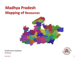
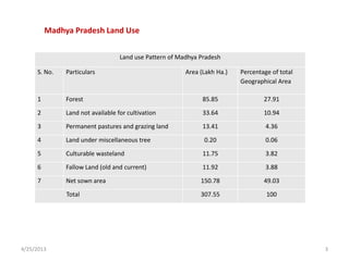
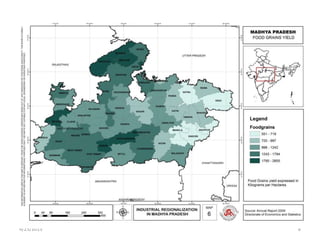
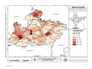
Madhya Pradesh
Mapping of Resources
Shubhranshu Upadhyay
SPA Bhopal
4/25/2013 1
4/25/2013 2
Madhya Pradesh: Geographic &Demographic profile
Madhya Pradesh is
centrally located state
bordering with five states
Gujarat, Maharashtra,
Rajasthan, Uttar Pradesh
and Chhattisgarh.
The State is spread over
308 thousand sq kms with
a population of 72.6
million.(Census 2011)
The state is 2nd largest in
terms of geographical area
and 6th largest in terms of
population.
The state is endowed with rich forest
resources with 31% of its geographic
area under forest cover contributing
to 13 % of countries forest reserves.
(India forest report 2009)
The state is endowed with mineral
resources such as Diamond,
Limestone, Purophylite, Diaspore,
Rock phosphhate and coal.
The state is largest producer of total
pulses 25.26%,Soyabean 59.03%, and
total oilseeds 25.18% (Economic
survey 2010-11 Government of India,
ministry of finance)
4/25/2013 3
Land use Pattern of Madhya Pradesh
S. No. Particulars Area (Lakh Ha.) Percentage of total
Geographical Area
1 Forest 85.85 27.91
2 Land not available for cultivation 33.64 10.94
3 Permanent pastures and grazing land 13.41 4.36
4 Land under miscellaneous tree 0.20 0.06
5 Culturable wasteland 11.75 3.82
6 Fallow Land (old and current) 11.92 3.88
7 Net sown area 150.78 49.03
Total 307.55 100
Madhya Pradesh Land Use
4/25/2013 4
4/25/2013 5
4/25/2013 6
4/25/2013 7
4/25/2013 8
4/25/2013 9
4/25/2013 10
4/25/2013 11
4/25/2013 12
4/25/2013 13
4/25/2013 14
4/25/2013 15
4/25/2013 16
4/25/2013 17
4/25/2013 18
4/25/2013 19
4/25/2013 20
4/25/2013 21
4/25/2013 22
4/25/2013 23
4/25/2013 24
4/25/2013 25
4/25/2013 26

GIS Mapping of Resources : Madhya Pradesh